Monday, 31 May 2021

A Better Entrance

This week we pause to consider a few of the issues which come about when a site is purchased and a note on a planning map: "future school", or in the case of Hatfield Road "future schools".

Whether primary or secondary there was a huge difference between what was provided in an educational building. In today's terms the facilities to be found in the pre 1902 Board schools or the later elementary establishments can be considered very basic , where even effective winter heating might be absent.  The County Council, on its formation, became responsible for building and maintaining schools where they were needed.  In the early years after formation in 1889 the Council engaged an architect for each individual school, but in the 20th century it set up an increasingly sophisticated architect department to develop standards common to groups of schools; and these standards developed and improved with time.

The Rural School Board were responsible for creating a school for the widely-spread child
population in surrounding hamlets.

So, using just a few select examples, what did we discover from actual experience?

You would have thought a mains water supply was a basic requirement, but Camp Elementary School was opened without a water supply extended this far from the nearest supply; and in Sandridge senior boys were detailed to carry water buckets from the village pump when required.

In 1908 (Fleetville Elementary School) lavatories were strictly outside at the far end of the playground; and the playground surface was gritted.

When the land was purchased for senior education in Fleetville the space was deemed sufficient for one boys' and one girls' school.  Ten years later when the girls Central School was built only one school could be accommodated.

The County Architect Department developed a building style with interchangeable components
This style of building is widely distributed across the county.  Staff at Beaumont Boys' School
in 1959.

By 1938 when the two senior schools were required even more urgently, Beaumont got its pupils in one building, girls upstairs and boys on the ground floor, with the absolute minimum of sharing!  Playing field space, according to the government, was required to be even greater.  The site reserved for a girls' grammar school in Brampton Road was instead used for a boys' school, while new housing hemmed the school in on all sides.  The regulations required more playing field acreage for boys than for girls; which is why the pupils of the Boys' Grammar School (now Verulam) have, since 1938, walked to their remote site in Sandpit Lane, and continue to do so.

A hall was multi-purpose in the early days, with a requirement to divide into two classrooms, even in the 1920s (London Colney).  It must also double up as a gymnasium in 1930 (Central).  Even Beaumont (1938) was in build when the next advance came, and a separate gymnasium with changing rooms became a new requirement.  This facility was also added to Central later.

When Beaumonts Girls' and Boys' Schools were designed a gymnasium what not required 
separate from the hall.  This new requirement was added as the schools were nearing completion.
Changing rooms were included.  When more modern sports hall facilities were later built the 
gymnasium was converted into a library centre.

From 1930 a platform suitable for drama was added to the hall at Central, and at Townsend an adjacent room was included for teaching and changing purposes, and by 1938 (Beaumont) two small classrooms were added for changing rooms.  Similar improvements were made for staff facilities and administration.  And considering many school still closed at lunchtimes down to the 1920s, catering facilities weren't added until post-war with many schools being supplied from central kitchens elsewhere in the city.

A detached house was included when required for the caretaker and his/her family.  This is at the Fleetville Juniors site, formerly Central, Girls' Grammar, Beaumont Girls, Sandfield; all names
applied to schools occupying the Hatfield Road school site since 1931.  The house no longer
serves its original function.

When schools might be built further away from the urban area and where caretakers need to be close at hand, the authority either acquired a nearby house or had one built in a part of the site.  This added provision was in place by the mid 1930s (Central – detached house), Marshalswick  (bungalow in 1959) and St Albans College (flat in 1959).

The main entrances to schools were also given a more prominent statement where possible.  Central was added in 1937 when the caretaker's house was built.  The need for parking, visitors, staff and other vehicular pressures often limited the possibilities, and Beaumont was only significantly improved within the last two or three years.

Camp and Fleetville schools have had to squeeze more onto their fixed plots even, in Camp's case the removal of a former head teacher's house, and in both cases removal of part of the schools' infrastructure onto new sites (Fleetville Juniors across the road onto Central,  overcrowding of Camp to form Windermere, and overcrowding of Fleetville to form Fleetville Extension School, renamed Oakwood).

Saturday, 15 May 2021

Battle From Hastings

 Occasionally, this blog takes a diversion from any series of posts which is currently running.  As regular readers already appreciate we are steadily working our way along the south side of Hatfield Road, but the previous post gave us a rare opportunity to explore a newly discovered turnpike mile post.  It came about through an exploration of what would, in the 1920s and 30s, have been a small rural school along Watford Road which was under threat of closure.  After that closure had taken place shortly before World War Two, the children having transferred to the new Mount Pleasant School, Bricket Wood, the building seems to have re-opened again in 1940.

A weekend camp by children from Hastings Grammar Boys' School while in Hertfordshire
during 1942.
COPYRIGHT UNKNOWN

St Albans played host to two groups of schools (and at least one college) for at least part of the duration of the war.  The first group arrived with the Pied Piper evacuation in September 1939 with schools from Camden, among them Princess Road, Haverstock Hill, Rhyll and New End.  The following year a second wave of evacuations arrived from the Hastings area, including the town's grammar schools. No definitive list of all schools who moved has been located, nor their host schools in the receiving areas, in our case St Albans.  So when a new school is discovered it is a cause for celebration, partly because it still triggers personal memories, and partly because it is part of the story for both host and evacuated schools and their towns.

Children from St Mary-at-the-Castle School, Hastings enjoying a meal at St Stephen's
Parish Hall in November 1940.
COURTESY HERTS ADVERTISER

In November 1940 the Herts Advertiser published a photograph of children and staff of St Mary-in-the-Castle School, Hastings.  They are seen enjoying a meal sitting in St Stephen's Parish Hall.  So far we do not know to which local school they were attached, but it is possible that the parish hall and St Stephen's closed school could  have been sufficient to accommodate them; St Mary's was not a large establishment.  From the above photograph it is clear that at least some of the children were of junior age, and as with many schools at the time St Mary's was an elementary School with all three departments, infant, junior and senior located in very old and outdated buildings in the cramped centre of Hastings.

We know the name of three adults from the caption: J W Brittain was the Head who accompanied the children, along with member of teaching staff Miss F A Poole.  Mrs Foster was the cook, who may have been local, or an adult – perhaps a parent – who came with the school.

The red roofed building in the centre, the former St Mary-in-the Castle School, still stands
in the centre of Hastings, but a current school with this name no longer exists, no doubt
having been subsumed into one or more larger establishments during the post-war period.
COURTESY GOOGLE EARTH

Some south coast schools returned to their home towns in 1942 when the bombing threats had subsided and it is assumed St Mary's did likewise. Before the school moved to St Albans the Sussex local authority had been planning a re-organisation of its schools and buildings.  When that process resumed after the war the original intention of retaining the original St Mary building came to nothing owing to its poor condition, and under new names and sites this and other schools became part of the Ore reorganisation in the 1950s.

Nevertheless, the people of St Albans were no doubt pleased to have hosted St Mary's-in-the-Castle School during its wartime evacuation. Equally, it is to be hoped the St Mary's children and their teachers enjoyed their time with us.  We know that many former evacuee children, as well as their hosts, remain in contact with each other via bespoke organisations, some with their own regular newsletters.  It may yet be possible to recover some memories of the connection between St Mary-in-the-Castle, Hastings, and St Albans.


Monday, 10 May 2021

More Turnpike Evidence

 The former Reading & Hatfield Turnpike road in the 18th and 19th centuries divided the north and south sides of Ellenbrook, Oaklands and Fleetville before the tolls were removed and the road was maintained at public expense by the Country authority.  Today we call it Hatfield Road which continues on its way through St Albans, St Stephen's Hill and Watford Road to Watford and Reading.

The mile marker along Hatfield Road outside Popefield Farm, near Smallford.

There is plenty we don't know about the turnpike's workings and toll collecting, but most of us are familiar with the Listed mile markers, still in position along the north side of the road.  If you wish to know more about the road in its toll days visit: 

http://www.stalbansowneastend.org.uk/topic-selection/turnpike-road/

The mile markers shown on that webpage are the only ones remaining; most of those following St Stephen's Hill through to Rickmansworth are missing, although they are referred to on the 1937 survey of the Ordnance Survey maps, and it is therefore assumed they remained by the roadside at least until then.  Many people are also aware that road signs were removed as a defensive measure at the beginning of WW2.  However, since no-one seems to recall those east of St Albans being removed and then returned, can the local authority be relied on to have treated those south of the city in the same way, even if it was the same authority?  Clearly not, since they are still not in place.

It has been suggested that the easiest method of managing such heavy metal objects when trying to remove them was to dig a hole beside each one, tip it in and cover it – job done!  But was that the full story and are the posts still there, below the ground nearby?

The focus of this post is the former mile post close to the Noke Hotel.

This section of the 1937 OS map shows the St Albans bypass (North Orbital Road) joining the Watford Road from the top right, at the location everyone knows as The Noke. The red circle identifies the position of the turnpike mile post to the left of the first and only carriageway when the new road was first built.  Lye Lane is the minor road crossing the bypass from the lower right.
COURTESY NATIONAL LIBRARY OF SCOTLAND

Quite by chance recently the Editor was following proposals during the 1930s for Hertfordshire County Council to close small rural schools and move any residual pupils into nearby town schools.  One such building was the school room in Watford Road which languished with 30 children by the time it closed in the 1930s, which is strange on two counts.  First, the Burston estate was being broken up and developed for housing, becoming the formative Chiswell Green.  The council, meanwhile pressed on with a new JMI school at Mount Pleasant, Bricket Wood; quite a distance for walking children from new St Stephen's and Chiswell Green homes.

The second consideration the council did not take into account was the completion of the St Albans By-Pass, linking up with Watford Road as far as the A41.  When first built it was a fast traffic single carriageway, but children from Chiswell Green and St Stephen's would have needed to cross this bypass to reach their new Mount Pleasant, for which the council provided a crossing patrol four times a day to supervise up to one hundred children across the bypass.

The lunchtime crossing patrol from the Lye Lane side. Between the second and third child from
the right can be spotted the light coloured turnpike mile post along the far fence line.
COURTESY HERTS ADVERTISER

Even today the road infrastructure has a dropped kerb and a fenced-off central reservation to enable
pedestrians to cross both carriageways.  This is where the children crossed in 1939.
COURTESY GOOGLE STREETVIEW

For our evidence it was fortunate the council elected to make the crossing point opposite Lye Lane; and it was also fortunate the Herts Advertiser considered the decision worthy of sending a staff photographer to the site.  The picture was taken as the children returned home at lunchtime and was standing where the bus layby is today.  It was taken at the beginning of June 1939.  What a responsibility for Mr H J Cornwall, the crossing man holding the board announcing "STOP. Crossing Patrol".

Now, just look between the second and third children from the right.  Along the fence line, and sitting just where the map says it should, is the turnpike mile marker, 3 miles from St Albans and 5 from Watford.  The Herts Advertiser has proved it.

An altogether more complex junction today for even faster traffic, buses, crossing
pedestrians (probably after leaving or boarding a bus) and vehicles leaving/joining one of
the side roads. The newer carriageway is on the left.
COURTESY GOOGLE EARTH

However, there is no point using a metal detector at the site today in the hope of locating the buried object.  Several improvements have been made to the bypass since then, including a second carriageway on that side of the road.  It may now be under the newer tarmac, or may have been removed from the site along with countless tons of rubble and subsoil in the construction of the dualled road.

But at least we still have photographed evidence it was present at the correct spot along the road in June 1939 and that several times a day it was passed by dozens of children on their way to and from Mount Pleasant School.

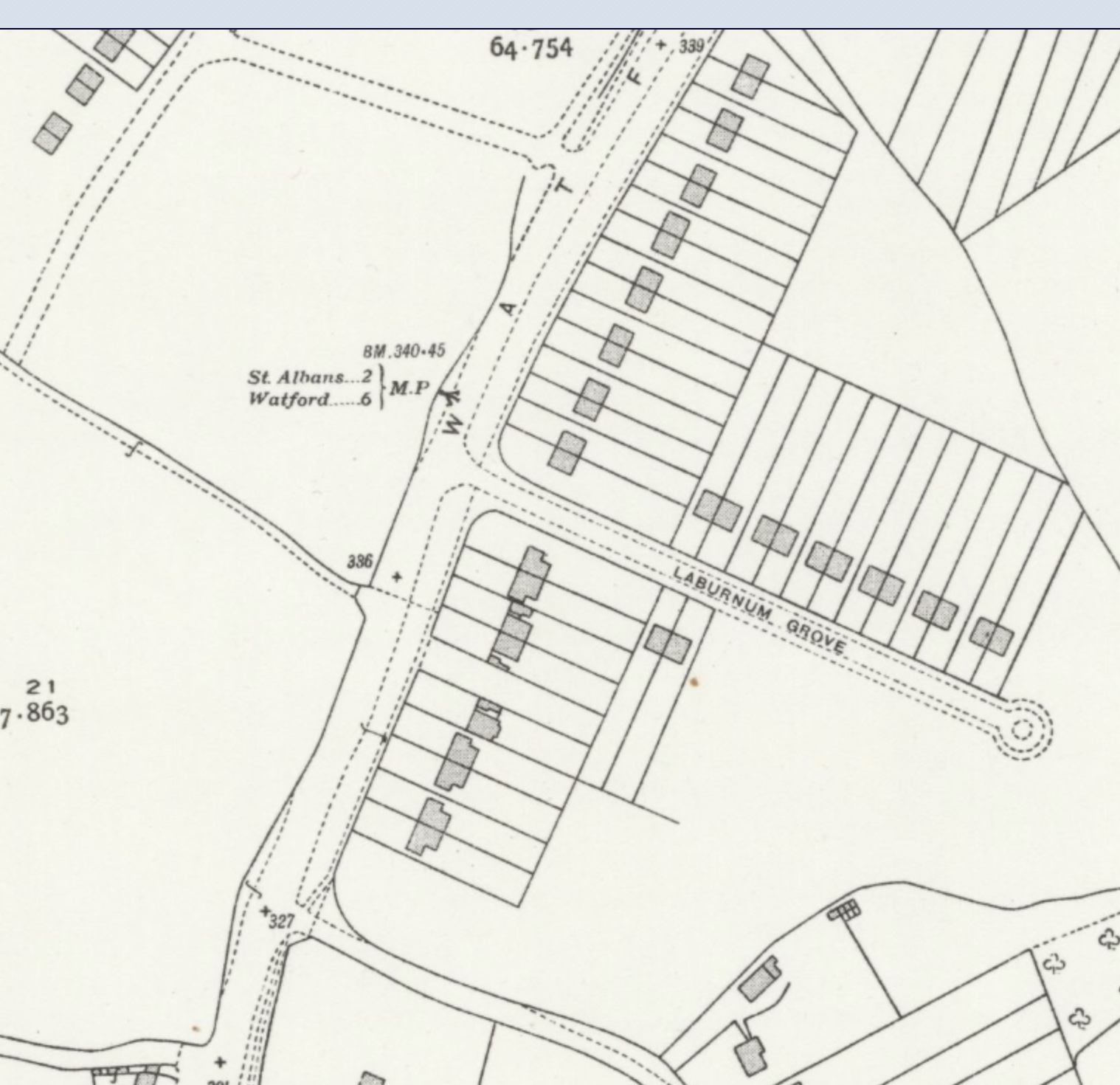
The location of the next turnpike mile marker was here (MP), along Watford Road, opposite its
junction with Laburnum Grove, just where the main road was a little wider.  Before
World War Two houses had not been built on the west side of Watford Road.
COURTESY NATIONAL LIBRARY OF SCOTLAND

The Watford Road/Laburnum Road junction today.  Do you think anyone took a photograph here
sometime before 1939?
COURTESY GOOGLE EARTH

And if anyone has a collection of photos pictures taken along Watford Road in Chiswell Green and taken in the 1930s, evidence of the next marker would be useful.  It stood opposite the end of Laburnam Grove, where Watford Road was always a little wider and where there is now a service road.  Before the war no new homes had been built opposite Laburnum Grove so the view would have been of open fields.

The account this week may not be be about the East End, but it is the same road which connects the two.  Let's try and solve the puzzle of  another turnpike mile marker.

Tuesday, 4 May 2021

Educational Future

 While we can way find our way along Hatfield Road by means of the frontage shops, we now have a choice: the premises which line the south side of the road, and the occupier of the back land.  We have reached the next of the fields owned by the St Albans Grammar School.  Hertfordshire County Council planned a three-stage re-organisation of schools which had been a mix of board and elementary schools, which had themselves been borne from an earlier collection of British and National schools.  One desperately urgent need was to separate senior pupils from infants and juniors to provide senior schools and distinct Junior Mixed and Infant Schools.

In 1925 Fleetville and Camp districts possessed no schools for senior children of either gender, and the council agreed to purchase a site of less than five acres for a pair of senior schools.  Quite what it thought would fit on this acreage for two schools and its attendant playgrounds is debatable, quite apart from a playing field.

The 1924 map shows the cemetery and a large undeveloped space to its east.
COURTESY NATIONAL LIBRARY OF SCOTLAND

Timber yard – see previous post – and a number of shops and business to the west by the time the
1937 map was published.  Behind is the site of the Central and Senior Girls' School in its original
square building and the separate handicraft building.
COURTESY NATIONAL LIBRARY OF SCOTLAND

From around 1918 a central school for girls had been operating in a rather ramshackle set of buildings in Victoria Street – partly a former  library, an arts and technology centre, boys' handicraft rooms and a school for girls who would benefit from a full four-year curriculum not limited to the existing leaving age of thirteen.  Most of these spaces had to be shared and were not for the exclusive use of the school.  And as the number of qualifying girls increased the available space became crowded.

New premises was desperately needed for the school and for practical rooms which could be shared with elementary schools lacking in these facilities.  So, new central school buildings came to Hatfield Road, and a search for a new pair of senior schools for the eastern districts would continue (and was eventually found at Oakwood Drive in 1938).

A cooking lesson in one of the practical classrooms.
COURTESY JENNY BOLTON

The new Central and Senior Girls' School school had no need of a frontage to the main road and so was not included in the sale to the education authority.  One pedestrian entrance, still used as such, was created at the eastern end between a motor factor (then West & Sellick and now CAMRA), and a further entry at the western end, later improved for access to the ancillary buildings, parking and a caretaker's house.

A typical HCC architectural design from the 1930s, of expanded buildings at Hatfield Road.
COURTESY JENNY BOLTON

By 1938 the school was changed to become a secondary St Albans Girls' Grammar School, with attendant increases in accommodation and for an increase in places.  In 1951 a new site was built for STAGGS in Sandridgebury Lane, originally intended to become a boys' secondary modern school – the county council changed its mind several times during this period!

Original handicraft and pupil teacher buildings, now unused on the site.


Overcrowded Fleetville JMI school earnestly hoped the former girls' school buildings would be available for them, but the inadequate Beaumont schools, new in 1938, became a boy's secondary modern and its girls formed a new school in Hatfield Road, first as Beaumont Girls school, and then altering its name to Sandfield Girls to avoid the name Beaumont being used for two sites in different locations. All of this new accommodation was required for an increase in the leaving age to 15. Instead, Fleetville Overflow School was constructed in Oakwood Drive, being named Oakwood JMI School in 1958 when it opened.

Aerial view of the current school, playing field, ancillary buildings and the former Family Centre.
COURTESY GOOGLE EARTH

Sandfield School later merged with Marshalswick Boys' School at The Ridgeway; and the parents of Fleetville JMI made a further attempt to move from their, by now, even more overcrowded Royal Road location.  This time they were more successful and the Junior department became custodians of the Hatfield Road buildings in 1975, enabling the infant department to spread out in Royal Road.

Fleetville Junior School is therefore the longest of the five occupiers of the buildings at forty-six years.  The first two occupiers would even have experienced the occasional passing of a train on the southern boundary!

Thursday, 29 April 2021

The Other Hotel

 We have become used to thinking of the printing works which launched Fleetville as having been possible through the purchase of the field known in the 19th century as Long Six Acre from its owners, St Albans Grammar School.  While this was undoubtedly true our misconception is that the firm of T E Smith for the printing works occupied the whole of that field.  It did not; not quite.  The western end of Long Six Acre extended to the boundary which today separates Fleetville Junior School at the back of the site from Morrison's car park.  The first formal occupation of this field remainder was the opening of a timber yard for the family firm of W H Laver soon after 1926.  The family choose to pronounce their name with a hard 'a'.

Between the branch railway at the bottom of the map and Hatfield Road lay two fields of
St Albans Grammar School.  The Fleet Works is on the right and the cemetery on the left.
Paths were laid out for allotments during the First World War. The block bordered in red
was first owned by Trust Houses and then W H Lavers.
COURTESY NATIONAL LIBRARY OF SCOTLAND


The 1937 map shows the various seasoning and storage areas, with the 'in' and 'out' drives.  To the
left is the original building of the school, and the narrow plot to the right of Laver's will be used by employees of Marconi Instruments in the 1960s.
COURTESY NATIONAL LIBRARY OF SCOTLAND

The red box of the Laver's site superimposed on current layout of the car park between the school and Morrison's.  This is the additional land purchased by Safeway.
COURTESY GOOGLE EARTH

Quite another proposal had been suggested at the time the printing works was in build.  The hotel group Trust Houses acquired a block of land which it intended to utilise for a hotel with full boarding facilities.

You will recall Benskin's purchased a similar block directly opposite and spent the best part of twenty years struggling to win over residents and the Justices for permission to open a public house in Fleetville.  Benskin's succeeded in the end, though it would be further along the road at Sutton Road.  Trust Houses were happy not to duplicate the battle, and eventually pulled out shortly before the Rats' Castle opened, selling its vacant plot to Laver's in 1926.

However, before Laver's arrived an extensive allotment garden, on both the remains of Long Six Acre, and on the next field to the west, Poor Six Acre. This is labelled on the first map above. There was an urgent need for land to augment farms, smallholdings and gardens during the First World War, and the Grammar School appeared to co-operate in releasing its land for this purpose, although the editor has not been successful in establishing how many plots were let, the yields which were possible, nor the quality of the soil.  The subsoil at the nearby cemetery is heavy clay, so tenants might have struggled.  The recreation ground narrowly escaped allotment fate, probably because of the quantity of available land on the south side of the main road.

Founder of the company William H Laver.

When the Laver's family opened for business, it was under founding member, William H, in the 1850s, working out of Corner Hall Wharf in Hemel Hempstead.  Most of the timber came from the Surrey Commercial Docks and brought to the site by canal.  Later the raw materials also came by rail, and in addition to the Wharf the firm opened sites in Merton Road and St Albans Road, Watford – the latter being a one-man yard.  By the 1930s the third generation replicated this arrangement with Hatfield Road as the main yard and a one-man yard next to the former fire station at the top of Victoria Street.

The timber yard site in the 1960s.
COURTESY ST ALBANS MUSEUMS

Although national and regional house builders supplied timber from their own sources, smaller companies and householders helped to make Laver's highly successful, even during lean economic periods and the rise of DIY sheds.  Only the limitation of price got in the way of the variety of timber, length availability, natural seasoning,  personal service and delivery options which Laver's were able to offer.

Newspaper advertising for the company in the 1930s

As with many family businesses a moment arrives when succession is no longer viable, but Laver's drove business for four generations from its brown and cream carts and trucks.  The Hatfield Road yard was sold to Safeway in 1992, and a number of employees were  transferred to Travis Perkins and therefore remained in the timber business. 

One further rider to the story of 238 Hatfield Road is a reference to the site in the Valuation Office record.  While it recognises the owner as Trust Houses, as stated above, also mentioned is the occupier of the land: Hertfordshire County Police.  The police had opened an operational station in Tess Road (Woodstock Road South) in c1906, and the Valuation Office Survey was not established until 1910, in which its interest in the Trust House land was noted.  The ground may have been for parking of vehicles or for training officers, but there is no evidence of there having been a building on the site.  All we can do is to note the occupation from 1910 with interest!

Finally, what do we know about Trust Houses and why might the company have acquired a new site in Fleetville?  Trust Houses was, in 1903, a new entity.  A number of influential families had become concerned about the diminishing standards of some of the country's well known but old established public houses and hotels, especially since the closure of turnpike roads, along which they had flourished.  TH began acquiring an interest in and upgrading their reputation, structure and service offering, some of the earliest being in Hertfordshire.  Part of the business model was to purchase new sites in order to expand the number of new premises; hence the Fleetville land.  In this case it was a question of licensing and in the end TH went elsewhere.

An early advertisement by Trust Houses Limited.
COURTESY GRACE'S GUIDE


Sunday, 18 April 2021

Wanted to Be On His Own

Today, Hutton Street is still a narrow street near Fleet Street, but comprise modern office buildings
instead of tightly grouped trading factories next to the Whitefriars Glass Works.

Hutton Street is tucked away behind the lower end of Fleet Street, near Ludgate in the City of London.  Its association with the printing industry was long established and many nearby firms developed as jobbing printers for the hundreds of City firms.  Thomas E Smith & Co was just one of them. Its footprint, like almost all back-street businesses, was typically small to reduce cost, but instead it grew upwards.

Fleet Street is just beyond the top margin of this map.
COURTESY NATIONAL LIBRARY OF SCOTLAND

In 1896 Smith's really wanted to expand into other ranges of work than churning out endless quantities of invoice blanks, letterheads and forms.  Colour work was attracting attention but the new colour machines were considerably larger and more complex, and were difficult to accommodate on the existing floor spaces, quite apart from the weight restrictions on upper floors.

Smith's inserted a promotional supplement into the 1907 St Albans Pageant book which it printed.
The Hutton Street premises is on the right and the expansive Fleet Works in Hatfield Road has
replaced the field sold to it by St Albans Grammar School.

Smith set up a separate arm of his business which he named the Smith Colour Printing Agency; and given that colour work would be in the form of catalogues, brochures, advertising and booklets, with the likelihood of large national distributions, a location away from London but with convenient transport connections was sought.

1896 was also the year in which the Trustees of St Albans Grammar School gave serious consideration to the inadequacy of its existing accommodation and to the future of the School. The tithe map reveals that with Earl Verulam the body owned three fields along Hatfield Road.  It was intended that the fields would be offered for development and the income used to create new buildings for the school.

The Grubb periscope and telescope works occupied the building c1916 and left in 1925. One or
two of the largest instruments were constructed in the open air at the back of the works.


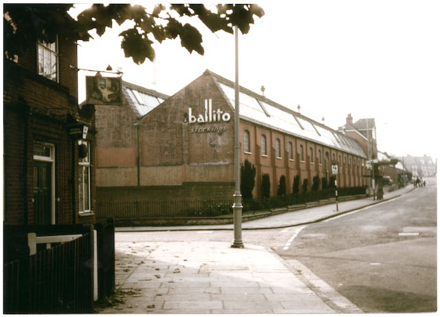
A 1950s view of the factory in the second phase of the Ballito era. The side road on the left
is Sutton Road and in the foreground was the toll house nicknamed the Rats' Castle.

Mr Smith required a large site but nowhere near where others lived, so there would be no distractions for his employees.  He would build homes for them, provide shops and an institute for their downtime needs.  He would not need public houses or other risqué entertainments, nor provide them himself.  So he purchased two of the three fields, one on each side of Hatfield Road and in an area he thought of as "remote".  The factory, called Fleet Works after his London printing centre of the company's origin, went up on the south side of the road.  Houses, shops and an institute were planned for the north side in a development he established as Fleet Ville.

So we now know exactly where it was because locals have been calling it Fleetville ever since.  And once you give a place a name people have reasons to be attracted to it.  No sooner had Smith's walls gone up than Earl Spencer sold his St Peter's Farm to add to the earlier housing at Granville and Cavendish; and the trustees of Beaumonts Farm disposed of the first tranche of its land.  Smith did not want his printing agency to be anywhere close to others; regrettably for him, that was not in his gift, and within a few years his factory and ville were surrounded by homes and workshops belonging to others.  But it did give him plenty of employees living close by, and a hugely successful business.

The field on which the factory was built, bounded by the branch railway, Sutton Road and Hatfield Road, gave the district its life blood.  T E Smith Printing Agency lasted until 1918 (although no work was likely to have been undertaken after 1916, the firm having lost almost all of its skilled employees during the war.  Sir Howard Grubb & Sons Ltd were clandestinely moved in by the Government to continue its submarine periscope research before developing some of the world's major optical telescopes.

An aerial of the expanded works with a multi-storey building.  The bus is passing in Hatfield
Road.  The greyed-out section top right includes the adjacent timber yard run by W H Laver.
COURTESY ST ALBANS MUSEUMS

In 1925 the buildings were acquired by the Ballington Hosiery Mills (brand name Ballito), another successful business both before and after the Second World War.  During the war the factory turned out millions of shell casings. 


Aerial view today but it includes the former timber yard. No part of the original factory complex
survives.  Although the supermarket is substantial in size it is still smaller than the factory it
replaced.
COURTESY GOOGLE EARTH

Ballito moved out in 1967 and the site became home to Marconi Instruments for a few years before the site was cleared for supermarket use: first the Cooperative Society, then Safeway and currently Morrison's.  We will return to this retailer next time as land has been added in recent times.


Saturday, 3 April 2021

What's that on the corner?

St Albans has been given a policing power as a borough and later city.  Most of the rest of the county was governed by the County Constabulary.  Before 1948 both forces were represented with buildings in Chequer Street and Victoria Street.  But this post is not about the history of these two bodies.  It is about what happened as a result of the expansion of St Albans.

The building on the right, at the top of Victoria Street, was the St Albans City Police Station,
 replaced in the 1960s by the new station recently demolished.
COURTESY ANDY LAWRENCE

Until 1913 the County Police found itself responsible for an increasing area east of The Crown as Camp and Fleetville districts spread, and some more rural communities expanded.  So a new St Albans Rural HQ was set up in Tess Road, now Woodstock Road South, where the nursery parking area is now situated.

In 1913 the city boundaries were expanded in several directions, most dominantly out towards Oaklands.  So the County's net spread wider and the City force took over within the new urban boundaries. Additional officers were therefore employed, but it became increasingly difficult without telephones for beat officers to report into Victoria Street from a wider patch while they were on duty.  And no easier for residents and business owners distant from the city centre to make contact with the police.

Police Call Box, location not yet identified, installed in 1932.
COURTESY HERTS ADVERTISER

Duty policeman seated inside to complete a report.
COURTESY HERTS ADVERTISER

In 1932 a number of portable police boxes or cabins were manufactured and sited in strategic locations.  An officer could then  complete forms and report by phone directly to the police station, either at the end of his duty, or on other urgent business.  When the station needed to contact the cabin a blue flashing light on the roof was lit.  If the officer on duty was sighted away from the box it was not unknown for members of the public to alert him "his Sergeant wants him on the phone!"  Residents could also use the phone directly to call the police station for the equivalent of a 999 service which had not yet been invented.  Although the phone was inside the cabin the listening and speaking parts were accessible from a little door outside.

By 1939 the wooden structures were deteriorating, and in preparation for wartime brick cabins with reinforced flat roofs replaced them. I was always aware of such a brick structure at the junction of Hatfield Road and Beechwood Avenue and had therefore assumed the earlier wooden cabin to have been there as well.

Brick replacement cabin with reinforced roof from 1939 located at the junction of
Hatfield Road and Beechwood Avenue.
COURTESY PHILIP ORDE

Recently I noticed in the background of a 1938 photo taken in Hatfield Road looking towards Ballito Hosiery Mill at Sutton Road corner, what looked very much like a wooden police cabin.  It was also marked on an OS map published in 1937 and therefore surveyed earlier.

Ordnance Survey map published 1937. The circled square in the corner of the Ballito Hosiery Mill
cycle yard is the Police Call Box.
COURTESY NATIONAL LIBRARY OF SCOTLAND


Circled in red is the PCB, or cabin, from the map above and pictured in 1938; this photo was also
shown in the post of 10th March.  The cabin is partly hidden by the hat of the lady walking towards Sutton Road and the Ballito Hosiery Mill.
COURTESY JANET STALEY HAINES COLLECTION

One of Fleetville's frequent flooding incidents, this in 1936. Circled is another view of the Police
Call Box.  The weather may have had something to do with the visibility of the
cabin in the picture!
COURTESY HERTS ADVERTISER

However, unlike other wooden cabins this one was not replaced in 1939.  So, did Fleetville not have a brick replacement?  It seems likely that during the later 1930s, and with the Beaumonts area expanding, the decision was made to shift the position of the brick cabin to Beechwood Avenue.  

I realise the quality of the photo was not good, so I was delighted this week to see another Herts Advertiser 1930s photo of flooding near Sutton Road; in the background was a wooden police cabin next to the footpath just inside Sutton Road, with its foundation just outside the end of the mill building where there was a row of cycle racks.

After World War Two the City Force was subsumed into the County Constabulary, and for as long as it was required the Woodstock Road South station continued to be occupied.

As telephone cables had been increasingly laid, lighter and slimmer police pillars appeared on a few street corners.

One of a range of pillar-type PCBs.  This was installed near St Peter's Green, St Peter's
Street.  No comfort, though, for police officers!
COURTESY HERTS ADVERTISER

But one final thought before the roll-out of relatively portable mobile communications: was there a wooden cabin, or later brick version, sited anywhere on the Camp side of the former railway line?  The 1937 map shows there was one at the Sandpit Lane entrance to The Wick.  The search continues.