Showing posts with label Fleet Works. Show all posts

Sunday, 18 April 2021

Wanted to Be On His Own

Today, Hutton Street is still a narrow street near Fleet Street, but comprise modern office buildings
instead of tightly grouped trading factories next to the Whitefriars Glass Works.

Hutton Street is tucked away behind the lower end of Fleet Street, near Ludgate in the City of London.  Its association with the printing industry was long established and many nearby firms developed as jobbing printers for the hundreds of City firms.  Thomas E Smith & Co was just one of them. Its footprint, like almost all back-street businesses, was typically small to reduce cost, but instead it grew upwards.

Fleet Street is just beyond the top margin of this map.
COURTESY NATIONAL LIBRARY OF SCOTLAND

In 1896 Smith's really wanted to expand into other ranges of work than churning out endless quantities of invoice blanks, letterheads and forms.  Colour work was attracting attention but the new colour machines were considerably larger and more complex, and were difficult to accommodate on the existing floor spaces, quite apart from the weight restrictions on upper floors.

Smith's inserted a promotional supplement into the 1907 St Albans Pageant book which it printed.
The Hutton Street premises is on the right and the expansive Fleet Works in Hatfield Road has
replaced the field sold to it by St Albans Grammar School.

Smith set up a separate arm of his business which he named the Smith Colour Printing Agency; and given that colour work would be in the form of catalogues, brochures, advertising and booklets, with the likelihood of large national distributions, a location away from London but with convenient transport connections was sought.

1896 was also the year in which the Trustees of St Albans Grammar School gave serious consideration to the inadequacy of its existing accommodation and to the future of the School. The tithe map reveals that with Earl Verulam the body owned three fields along Hatfield Road.  It was intended that the fields would be offered for development and the income used to create new buildings for the school.

The Grubb periscope and telescope works occupied the building c1916 and left in 1925. One or
two of the largest instruments were constructed in the open air at the back of the works.


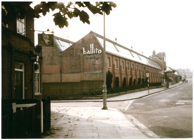
A 1950s view of the factory in the second phase of the Ballito era. The side road on the left
is Sutton Road and in the foreground was the toll house nicknamed the Rats' Castle.

Mr Smith required a large site but nowhere near where others lived, so there would be no distractions for his employees.  He would build homes for them, provide shops and an institute for their downtime needs.  He would not need public houses or other risqué entertainments, nor provide them himself.  So he purchased two of the three fields, one on each side of Hatfield Road and in an area he thought of as "remote".  The factory, called Fleet Works after his London printing centre of the company's origin, went up on the south side of the road.  Houses, shops and an institute were planned for the north side in a development he established as Fleet Ville.

So we now know exactly where it was because locals have been calling it Fleetville ever since.  And once you give a place a name people have reasons to be attracted to it.  No sooner had Smith's walls gone up than Earl Spencer sold his St Peter's Farm to add to the earlier housing at Granville and Cavendish; and the trustees of Beaumonts Farm disposed of the first tranche of its land.  Smith did not want his printing agency to be anywhere close to others; regrettably for him, that was not in his gift, and within a few years his factory and ville were surrounded by homes and workshops belonging to others.  But it did give him plenty of employees living close by, and a hugely successful business.

The field on which the factory was built, bounded by the branch railway, Sutton Road and Hatfield Road, gave the district its life blood.  T E Smith Printing Agency lasted until 1918 (although no work was likely to have been undertaken after 1916, the firm having lost almost all of its skilled employees during the war.  Sir Howard Grubb & Sons Ltd were clandestinely moved in by the Government to continue its submarine periscope research before developing some of the world's major optical telescopes.

An aerial of the expanded works with a multi-storey building.  The bus is passing in Hatfield
Road.  The greyed-out section top right includes the adjacent timber yard run by W H Laver.
COURTESY ST ALBANS MUSEUMS

In 1925 the buildings were acquired by the Ballington Hosiery Mills (brand name Ballito), another successful business both before and after the Second World War.  During the war the factory turned out millions of shell casings. 


Aerial view today but it includes the former timber yard. No part of the original factory complex
survives.  Although the supermarket is substantial in size it is still smaller than the factory it
replaced.
COURTESY GOOGLE EARTH

Ballito moved out in 1967 and the site became home to Marconi Instruments for a few years before the site was cleared for supermarket use: first the Cooperative Society, then Safeway and currently Morrison's.  We will return to this retailer next time as land has been added in recent times.


Wednesday, 19 February 2020

Without a Name

Some years ago a recollection by a long-established resident of Fleetville lead to an unusual discovery.  The former Smith's Institute building, on the corner of Hatfield Road and Arthur Road, has undergone a considerable number of changes during the past 126 years.  It was built to perform the role of an employees' social club at a time when the printing factory (on the Morrison's site) and a few employee houses were all to be had in the embryonic suburb.


The Institute when new.  The commemorative stone
panel is just below window level at the building's corner.
It has been extended further into Arthur Road, had doorways altered, the facings have changed, and most of the ground floor internal walls removed to enable later printing machines to be installed.  

But one person recalled that on a corner wall there had at one time been a stone panel marking the formal opening of the building by the Mayor.  The event had taken place in 1899.  After having been covered by a modern facing, a contractor had drilled through the panel – although he did not realise it – to install a gas pipe.


The same building recently.
A few years ago the facing was removed to confirm the presence of the remembered panel.  We all looked at it and then continued with our lives.  But it is worth looking at again, because there maybe a story attached.  "This stone was laid June 24th 1899 by Thomas Smith Esq, donor of the Institute."  That much is plain to see.  Mr Smith's name is bold enough, and so was his role.  He both owned the new printing factory on the opposite side of the road, and he had given the money to pay for his employees' club building.  We know from other documents that he set up a trust fund from his own monies; the resources did not come from the company.

"Which was opened by His Worshipful the Mayor of St Albans Dec 2nd 1899."

These days the new Mayor is appointed in May when the local elections take place, but in 1899 the elections, and therefore Mayor-making were in November.  If you were going to invite the Mayor all the way out to Fleetville, especially as Fleetville was then outside the city boundary, to open the building you are so proud of, surely you would give him the honour of including his name rather than just calling him The Mayor.  The man had a name, and it doesn't take that long to carve his name into the stone panel.  On the day of the opening ceremony and the speech given by the Mayor it was clear he was excited to be present on that winter's day and he expressed the hope that Thomas Smith would one day wish to move his home (from Enfield) to live in the city.  The mayor was anticipating in return that the city would move the boundary outwards to include Fleetville.  Both of these hoped for targets would, of course, benefit the finances of St Albans.


Henry J Toulmin
ST ALBANS MUSEUMS
OK, so the time has come to reveal the name of the mayor, both in 1899 and 1900.  It was Henry Joseph Toulmin, whose home was at Childwickbury, also outside of the city boundary!

There are two other relevant facts which might fit into this story.  Thomas Smith was, by politics, a Liberal; Henry Toulmin was a Conservative.  Perhaps that was the reason why His Worshipful the Mayor was not mentioned by name; and it would ensure for the life of the Institute, that Thomas E Smith would be the name associated with this structural gift to his own little hamlet of Fleetville.  Job done!

Saturday, 1 February 2020

A Mile is Not a Mile

There are many puzzles about the Hatfield Road cast iron mileposts and what they tell us.  These posts are reminders of the Turnpike road between Hatfield and Reading, and in this district the only posts left are at Ellenbrook, Popefield, Oaklands, Fleetville, The Peacock PH and St Stephens Hill.  All of the others have disappeared.


Turnpike mile marker at Fleetville
Recreation Ground.
The Fleetville marker may still be present, but it has moved.  It is currently on the corner of Hatfield Road and Royal Road, but there are people who seem to recall it has not always been there.  But if it is a mile marker it should be exactly one mile from the previous mile post at Oaklands; in its current location it is further than that.  Ordnance Survey maps up to and including 1924 locate the post outside a shop on Bycullah Terrace.  The marker is not shown on the 1937 map, either in its original location nor any other.

Of course, the post, when first installed, was at the roadside in front of a field in the countryside – Fleetville was still to be invented!  When Bycullah Terrace was built c1900 the property doorways were arranged around the location of the post, although it can't be ruled out that the post was moved along the road by a yard or two!  


Numbers 207 and 209 Hatfield Road
Photographic evidence is also absent.  Two fine postcard photos of Bycullah Terrace dating from approximately 1914 show the shops both from the west and the east, but obstructions and shadows on both views hide a potential post.  The map suggests it should be present outside number 209, presently an optician's premises, but in 1930 was a house occupied by Dr Frederick Smythe.  Dr Smythe then had a house built on the corner of Royal Road – Fleet House – which gave the new owner of 209 the opportunity of opening up the front,  first built as a manager's house for the Fleet Print Works, for use as a shop.


Bastin's plan showing the mile marker position.
But absence of the post from its measured location is intriguing, and until recently we still couldn't be conclusive about where it was being stored.  Now, as a result of a recent find we can be more specific about its removal.

William Bastin was a Fleetville-based builder and had his yard, now occupied by Chapman's Auto Centre, just east of the Rats' Castle.  Albert Smith acquired Dr Smythe's premises at 209, with the intention of opening it as a bakery.  He therefore engaged William Bastin to draw up plans, which he did before realising there was an obstruction: the Turnpike milepost!  We know this because the post was drawn onto the plan by hand afterwards.


Proposed new shop front showing where the milestone
would obstruct the shop door.

This is therefore the first visual proof of its exact location.  While it was satisfactory for the building before modification – it stood in front of a piece of blank wall – the planned shop required the entrance to the shop to be located on the left, while the existing door on the right would give access to the first floor flat.  It seems that some negotiation must have taken place with St Albans Council, which then agreed for its removal and storage.  It is thought that the post re-appeared when Hatfield Road was widened slightly at the recreation ground.

The answer to the question, where was the post in Bycullah Terrace?  Between numbers 207 and 209.

The answer to the question, when was the post moved?  The plan is dated 1933 and Mr Smith was trading by 1934.