Wednesday 27 July 2022

Beaumonts in 1946

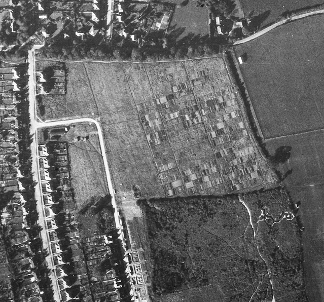
 This week I am drawn to an aerial image I know so well, and I was already a toddler when the RAF photo reconnaissance planes flew over our house in the autumn of 1946.  This part of St Albans was my very own playpark: Beaumonts estate, although I can't remember many people using that name once the houses came out of the ground.  Because one of the first new roads to be laid was Beechwood Avenue I think we explained where we lived as being  "off Beechwood".


This week's RAF photo flyover in 1946 has picked out details of Beaumonts estate,
begun in 1929 and paused in 1940.  We can even see the continuation of the housing 
at the Willow estate south of Hatfield Road.
COURTESY HISTORIC ENGLAND


Not removed promptly after the Second World War was this circular emergency water
tank on the corner of Elm Drive and Oakwood Drive.  A house would occupy this corner in the
1950s but temporarily the tank enabled a water supply of sorts to be available (lemon yellow
circle).
COURTESY HISTORIC ENGLAND


Beaumont School in Oakwood Drive was completed in 1938, and the grounds
extended southwards to Hatfield Road a decade later.  The orange circles show
where the postwar HORSA classrooms would be added in 1947, the southern two on top
of the emergency underground shelter tunnels.  The boys' and girls' semi-outdoor
toilets are circled in red; and the ARP warden's brick hut (green) was next to the pedestrian
entrance from Oakwood Drive.
COURTESY HISTORIC ENGLAND


Today's much expanded school with little of the original playing field space left.  The 1938 
classroom block and halls, and the now enveloped former gymnasium further north help us to
navigate the site.
COURTESY GOOGLE EARTH

The first photograph shows Oakwood Drive, with Hatfield Road in the lower half.  These houses are already well-established, having been constructed in the 1930s, and the inevitable dislike of developers for building on many of the street corners resulted in pedestrian short cuts across future plots.  The second photograph highlights a circular shape on one of the corners (lemon yellow circle), between Elm Drive and Oakwood Drive.  This was one of the many emergency water tanks that had not yet been removed.  Not intended as a drinking water supply, but for fire fighting purposes in the event of dislocation of the public water supply during bombing.  On the eastern corner of that junction it gives the impression that  Elm Drive might continue, as indeed had been intended when the plans were first submitted to the council in 1929.  However,  in 1936 the County Council purchased the land for the school and this continuation of Elm Drive, and other residential streets, was unable to proceed.

Beaumont School was created behind the Oakwood Drive houses; the large rectangular classroom block intersected by the assembly halls and dining halls – one pair for each of the boys' and girls' schools, separated by floor.  The large building north of this was the gymnasium and changing rooms, and to the west was the workshop classroom.  In a few months would arrive three separate HORSA (Huts fOr the Raising of the School Age) buildings ready for when the leaving age was raised to 15 as authorised by the 1944 Education Act.  These would be erected on the land then previously used for the underground tunnel shelters for each school (orange circles) and an additional building north of the gymnasium.  The latter contained two classrooms used as the formative Fleetville Extension School (Oakwood JMI) in 1957.

Although outside school toilets had formally been dispensed with, those at Beaumont were not quite fully inside.  The small red circles show the location of the boys' and girls' toilets next to the respective playgrounds, each linked to the main building with an open but roofed walkway.  A further small (green) circled building was demolished in the 1960s, having been built specifically as an ARP warden hut during the Second World War.  Between south of the main classroom block and the playing field were, and partly still are, the school gardens.  Today the gardens are more ornamental, inspirational, but rather smaller.  During and after the war they were for vegetable growing and to support the County Council's pioneering Rural Studies curriculum.

Between the southern boundary of the field and Hatfield Road the photo shows a shrubbery not initially purchased by the County Council as it was intended to continue house building along Hatfield Road as well as an Elm Drive extension – referred to above – behind.  However, the school's upgraded requirements by the late 1940s meant the additional land was acquired to extend the field, with the exception of a strip adjacent to Hatfield Road on which was built the Bunch of Cherries public house, now the Speckled Hen.

The core of roads on the estate as developed in 1946.  The blue circle locates the temporary
war-time timber hut used by the local Home Guard Unit, whose members are pictured below. 
The turquoise circle locates the remains of the medieval moat surrounding a former Manor House.
COURTESY HISTORIC ENGLAND


See caption above.

Two images above shows Central Drive crossing from west to east.  The westerly Beechwood Avenue and Woodland Drive have been, or are being developed; Hazelwood Drive north has yet to be started and the Oakwood Drive north link towards Sandpit Lane was aborted.  None of the houses in Central Drive has been started in 1946, although we can see former tracks on each side of the newer roadway.  North of the Hazelwood Drive junction a small wooden hut remains (circled blue), which had served as the training hut for the local Home Guard Unit.
.

The farm house was demolished in 1938 and was situated immediately south of the foundations of the new houses on the east side of Woodland Drive north.

A young resident of Woodland Drive north in the front garden, with stacks of bricks ready to
build on the foundations of the homes.  This photograph was taken a few months after the RAF 
flyover.

The urgency to start new council house building has resulted in the footings for five pairs of homes in Woodland Drive north being laid (they being right opposite our 1939-finished house) and the remaining part of the moat in front of the medieval Manor House can be seen on the south side of Central Drive.  To the west of Beechwood Avenue and opposite to the newly created Central Drive remains the former farm lane, now called Farm Road, which was originally intended to be part of Central Drive to link with Beaumont Avenue.  It remains a private and unmade lane, although homes have somehow been shoe-horned into the space using parts of the original rear gardens in Beechwood and Beaumont avenues.

Beechwood Avenue, extreme left, with Woodland Drive north parallel, the latter joining the former as the beginnings of Chestnut Drive.  A rather rural Sandpit Lane runs west-to-east along the top of the 
photos and hidden behind the belt of trees.  Here are the extensive Beechwood Avenue Allotments, and further east is the playing field of what is now Verulam School in Brampton Road.
COURTESY HISTORIC ENGLAND


One of the temporary buildings (at least since c1900) on the corner of Beechwood Avenue and
Chestnut Drive was used for a short time as a Sunday school for St Paul's Church, serving the
children then growing up on the Beaumonts estate.
COURTESY SHEILA ARTISS

Tacchi & Burgess, a large building firm at the time, constructed about 20 houses on the south
side of Sandpit Lane on the edge of Beaumonts Farm.  It erected this bold sign along Hatfield Road
 to attract potential purchasers to the development in the 1950s.  
COURTESY PHILIP ORDE

The road at the bottom of the photo is Sandpit Lane, with the camera facing south and hovering over
Rose Walk.  The Tacchi & Burgess development spreads along Sandpit Lane lower centre.
COURTESY GOOGLE EARTH

The third photo shows Beechwood Avenue and Woodland Drive north; the stub of a road joining them would later be extended to become Chestnut Drive.  At the Beechwood end of this road are three agricultural buildings, including two Nissen huts erected soon after  Beaumonts Farm was first sold to become part of Oaklands estate farm in 1899.  East of Woodland Drive north shows evidence of the large swathe of allotments, named Beechwood Avenue Allotments, leased by St Albans Council for the wartime period.  On one of these my father grew food for his growing family. By 1946 many of these plots were given up as the Council needed to hand the site back to land owner Watford Land Holdings, although some tenants were able to continue working their plots until 1948.

North of the allotments, and hidden by a narrow belt of trees, can be seen Sandpit Lane which was the northern boundary of Beaumonts Farm.  Sandpits was a rural lane at this point, there being no formal footpath, although the aerial photo identifies a footpath on the southern edge of the tree belt.  This was still accessible from Beechwood Avenue.  During the 1950s house builder Tacchi & Burgess removed the tree belt and constructed nearly 20 detached homes fronting onto Sandpit Lane.  The company erected a hoarding advertisement for the houses on the corner of Hatfield Road and Beechwood Avenue on a site which was previously a builder's yard for one of the house building companies engaged on developing the lower part of Beechwood Avenue.

Seventy or so years later, many of the homes have received extensions of one kind or another.  The pre-war developments were, of course, the last of homes with generous gardens on 30-feet wide plots.  The little unintended pocket park originally reserved for a church and shops, and then for a Bensons public house, instead was used for children's informal games before the arrival of the Central Drive shops and flats, and Irene Stebbings House.  Children do still have an open space to play on, but today the green in Hazelwood Drive is really an 'amenity space' – there remains the frame of a sign which in earlier times proclaimed NO BALL GAMES. 


Wednesday 20 July 2022

Clarence Park in 1946


Many of our popular sites in the city give the impression of being timeless; old friends, that since their creation have experienced few changes, just the process of ageing gently.  Clarence Park is one such location, now reaching its 128th birthday.  In 1946 when the RAF overflew the eastern side of St Albans the park was only 52 years old.  It is doubtful there had been an actual celebration – we would have other priorities at the time.  The photographic negative seems to have been ageing gently too, with well scattered specks across its surface; or perhaps it just needed a good clean!

Clarence Park in 1946; the three major land areas: cricket ground, football pitch, and the recreation ground bottom left.  The three circled features: wartime decontamination unit (orange/yellow);
refreshment chalet (red); spectator stand (green).
COURTESY HISTORIC ENGLAND

Clarence Park has received a few changes since its opening by HRH Duke of Cambridge in 1894: maturing flower beds, shrubs and magnificent trees; the separation of football and tennis, previously sharing the same plot according to season; the formation of a bowls club; the addition of a refreshment chalet and, for a time a cinder cycling track.  Not every facility proved successful; the original  bandstand of timber with wicker and thatch roof was the first to succumb, and although public toilets were added at The Crown boundary in the 1920s, toilet facilities are probably today in poorer state than they have ever been.

Aerial view a little further south.  The circled features: location of former roundabout and bucking
horse for children (turquoise); witch's hat and swings (blue). The green arrow locates the gateway between the two major sections of the park; and the pink outline shows the location of former
St Peter's Farm, now Conservative Club.  Granville Road is identified in orange at the
bottom of the photo.
COURTESY HISTORIC ENGLAND

The park when first laid out, from the entrance by Hatfield Road bridge. The shadow of the photographer's camera on a tripod is thrown onto the bend of the pathway from the bridge.
COURTESY ST ALBANS MUSEUMS

The cricket pavilion, bottom left, with the refreshment pavilion in the centre.  The embanked and
fenced terraces of the football ground from a period before the turnstiles were installed.

An original pedestrian gate opposite Granville Road was finally closed in the 1950s, the result of increasing traffic in Hatfield Road just up from The Crown and therefore posing an increased risk of accidents.  In the second photograph the sun is shining across from the end of Granville Road as if forming a virtual crossing towards the park.

An end of bowls.

Also in the recreation ground near Clarence Road are two white patches which represented two children's features of the time: the cone, or witch's hat, and the old favourite of swings.  A small roundabout and bucking horse were sited near the gate leading to the cricket ground.  Today the much enlarged area has been upgraded as a very colourful playpark.

Though this example is not at Clarence Park the Witch's Hat provided enjoyment for all.

Though this example is not at Clarence Park the horse it is very similar. Hold on to your seats!


Designer's drawing of the new playpark where the former roundabout and horse used to be.


The circular interruption along the path across the recreation ground was the old bandstand – and is now the new bandstand.  But in 1946 the Parks Department had arranged regular seasonal flower shows on what was then a raised circular bed.

Today's bandstand is on the same site as the original timber structure, but I wonder how many
concerts take place here today.

Location of one of the Second World War underground shelters in the recreation ground, close to the memorial drinking fountain.

The first occasion during which the park was commandeered for alternative uses came during the First World War, its open spaces being used for troop training.  In 1939 the park was once more under threat.  A first aid centre and gas decontamination unit was set up in the area behind the cricket pavilion (orange circle in the top photograph).  Two unidentified buildings remained near the gate leading to the recreation ground.  Public underground shelters were excavated near the Hatfield Road path in the recreation ground.  They serviced employees from the nearby factory of W O Peake Ltd, as well as park users and nearby residents.  In particularly dry summers it is still possible to identify the long lost rectangles and square emergency exits in the parched grass.  In fact the regularly spaced square exit slabs stand out clearly on the edge of the shadows on the second aerial photo.  Several facilities for civilians were set up to encourage young men to maintain their fitness; and schools and clubs, including evacuated schools, continued to use the spaces for organised sport and games.

Public Toilets facing out onto The Crown junction, but now converted into a restaurant for 
Verdi's.
COURTESY ST ALBANS MUSEUMS

Focusing on the Maple-inspired cricket ground, which was previously part of St Peter's Farm, we would find the early cinder cycle track has gone, and the two parallel light lines from the top two photographs indicate the 1920s addition of tennis courts (today they are multi-use courts) funded by a donation from Samuel Ryder.  At the northern end of the ground was a tiered stand seen in the 1946 photo (green circle).  Presumably it was for those not privileged to be admitted to the pavilion.  The stand was removed many years ago, but behind it was, and still is, a maintenance area and sensory garden.

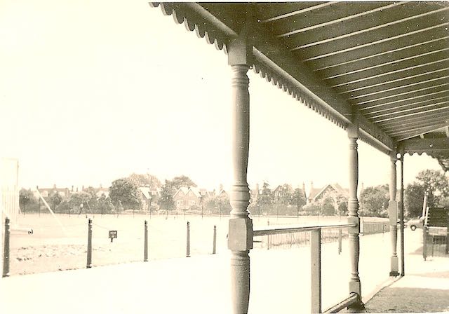
This is the only image I have discovered of the refreshment kiosk overlooking the cricket ground,
with the steps of the cricket pavilion seen through the end of the kiosk's verandah.
COURTESY BETTY EWENS

A popular refreshment chalet next to the welcoming shade of a mature tree (red circle), occupied a grass triangle between the cricket ground and football pitch.  That little building has also been removed, leaving no refreshment facility in the park.  The Council built public toilets at the Crown boundary.  That was back in the 1920s.  The only other, rather rudimentary, facilities are near the football pitch and the bowling green, the latter available with a RADAR key.  For many years these have remained the only facilities  since the Council leased the Crown toilets to a restaurant business.  

Anyone enjoying the Park in 1946 and returning today would discover remarkably few changes.


Saturday 9 July 2022

Ellenbrook in 1946

 In the next of the series of posts inspired by a series of aerial photographs, we have hovered over Ellenbrook, which before modern times was neither part of Hatfield nor an outlier of St Albans.  A collection of aerial photographs appears on the website of Historic England (HE), part of a survey undertaken by the RAF in 1946.  Unless HE has been selective in what it has published from its archive we believe the survey aircraft made a single sweep west-to-east over St Albans.

The featured imaged looks down on part of St Albans Road West and de Havilland Aircraft
Company.  This 1946 survey shot also includes the Comet Hotel (right lower centre) finished in 1936.
COURTESY HISTORIC ENGLAND

To locate our bearings, the image above is broadly as map and compass with north at the top of the photo.  The road in the lower half of the picture is St Albans Road West with Smallford on the left.  It joins what is now Comet Way (formerly called the Barnet Bypass laid in the 1920s) which joins the photo on the right from the Welwyn Garden City direction and sweeps southeastwards to meet the A1 – now the A1(M) Roehyde Interchange.  The only other roads  of note are the private service road linking the many facilities within de Havilland Aircraft Company, and in the top right corner a lane which linked St Albans Road West and Harpsfield Hall Farm.  The remains of this farm could be seen to the right of the lane.  

Harpsfield Hall Farm which was demolished to accommodate the expansive aeronautical activity.


A late 1920s view of the Flying Club between the completion of the bypass and the
arrival of de Havilland Aircraft Company, which relocated from Stag Lane,
Edgware. The future site of Comet Hotel is left centre with the mentioned 
Ellenbrook homes c1910 beyond along St Albans Road West meandering towards
St Albans.

From the massive hanger to the smaller specialist workshops this company had, of course, completed its massive output of Mosquito aircraft.  It had first occupied the site in 1929, taking over parts of three farms: Harpsfield in the north-east, Nast Hyde in the south, and Popefield in the west.

However, the landscape was not completely empty when DH arrived, for the London Flying Club had occupied the eastern part of the site from the early 1920s.  During that time it was known as the Hatfield Airfield.  

There was even development activity before then.  During the first decade of the 20th century land from Nast Hyde was sold to defray costs of upgrading Great Nast Hyde House.  New houses were erected in St Albans Road West and in Ellenbrook Lane from 1910, and to attract potential owners a golf course was laid out beyond the north side of St Albans Road West, and an agreement was reached with the Great Northern Railway to erect a halt (Nast Hyde Halt) so that residents could board a train to Hatfield Station and then join a fast service to London Kings Cross.  The development was brought to a halt soon after 1914 with the golf course later buried under DH's runway.  Housing on the south side of the main road eventually became the Selwyn and Poplar estates.

Ordnance Survey map from 1937 showing the location of the former homes on the north side
of St Albans Road West.  Comet Hotel is at the map's centre.
COURTESY NATIONAL LIBRARY OF SCOTLAND

Occupying a broad swathe across the middle of the aerial photo can be seen a few of the early Nast Hyde houses, sandwiched between the main road and the DH service road. Most of the heads of household had London-based jobs, which supported their wide and long plots on which were spacious detached homes.  The house furthest east (where now is the Mosquito roundabout) can be identified by its wide C-shaped front drive.  It was later converted into a social base for the Flying Club; and the last house in the development became a hotel now known as Beales.

As the land demands of de Havillands increased so the houses along the main road were sacrificed.  If you had travelled from St Albans to Hatfield by bus in the post-war period you may have been aware of the homes – and then they were gone!  Today the expansive university parking zone occupies where those families once lived.

The Benskin Comet Hotel newly finished in 1936, showing the beacon on the roof.

In order to allow the Barnet Bypass to connect with the A1 in the late 1920s – shown on the photograph lined with poplar trees – the then  Ministry of Transport negotiated with the Nast Hyde estate to purchase a swathe of land.  Benskin's Brewery took the opportunity of purchasing a triangle of land in a prime position just where the bypass curved off towards the south-west.  The public house and hotel which it had built, and is now listed, took its name from the newly arrived de Havilland Aircraft Company, calling it the Comet, referring not to the post war jet aircraft but the Comet Racer of the thirties.  A motif of this iconic aeroplane has been displayed on the hotel's frontage ever since.  

The Comet Hotel was not just an ordinary hotel design. The architect was keen to shape it in the form of an aeroplane, which can really only be appreciated from the air.  Cockpit, fuselage, tail and wings, albeit stumpy ones, can all be identified.  It is possible that the wings could later have been extended had the need arisen, but this did not occur.  Today the Comet has been fully restored to its original design, following a number of ill-conceived alterations over the years.  Even the roof beacon has been replaced, the purpose of which had been to guide early pilots of small aircraft to the airfield in the days before radio guidance.  The grounds appear surprisingly spacious and the car park uncluttered; although in 1946 a new entrance/exit has been laid to Comet Way to add to the access on St Albans Road West.  The gardens to the rear of the Hotel have now themselves been developed with new student accommodation.

The extension to the top featured image, also taken in 1946.  The C-shaped drive at the house opposite
the Comet Hotel car park is on the extreme left (both of the lower left corner), and the turn-off right towards Hatfield is top right, above which can be seen the former Stone House Hotel with the light coloured surfacing.  Its location can be identified because the road St Albans Road West still exist although the bypass end is now covered by the Galleria car park.
COURTESY HISTORIC ENGLAND

This week I have added an extension to the featured aerial image, borrowed from part of the adjacent photo.  The main road eastwards joins the Barnet ByPass, and from memory was controlled by a set of traffic signals.  By the 1950s the bypass was very busy and Hatfield New Town was emerging.  On the supplementary image the junction is on the lower left – just below that C-shaped front drive I wrote about above.  To reach the centre of Hatfield by bike, car or bus, vehicles kept to the right lane on the bypass until reaching the wide gap at the next junction on the right, which is a continuation of St Albans Road West.  When traffic flow allowed drivers moved forward to enter the new road.  Today this is at the parking end of the Galleria.

Cavendish Road bridge when newly finished in 1956.  The photograph was taken from the 
Queensway roundabout.  The bridge was demolished c1983 and replaced by ...
COURTESY HERTFORDSHIRE ARCHIVES & LOCAL STUDIES


... a flatter bridge under which is the Hatfield Tunnel.  The Galleria shopping centre, on the far side on the right, was constructed over the tunnel.
COURTESY GOOGLE STREET VIEW

Of course, today at the  roundabout in front of the Comet Hotel there is a new road, Cavendish Way, which is part of Hatfield New Town's strategic road network.  When created in the 1950s it bridged the Hatfield & St Albans Railway, which had already closed for passengers.  Hatfield bound buses diverted to this new road and then used Queensway to reach the centre of the New Town.  The bridge was replaced in the 1980s in order to bridge, not only a now closed railway (Alban Way), but also Hatfield Tunnel.

How this entry to Hatfield has altered in the past hundred years.