Showing posts with label shelters. Show all posts

Wednesday, 20 July 2022

Clarence Park in 1946


Many of our popular sites in the city give the impression of being timeless; old friends, that since their creation have experienced few changes, just the process of ageing gently.  Clarence Park is one such location, now reaching its 128th birthday.  In 1946 when the RAF overflew the eastern side of St Albans the park was only 52 years old.  It is doubtful there had been an actual celebration – we would have other priorities at the time.  The photographic negative seems to have been ageing gently too, with well scattered specks across its surface; or perhaps it just needed a good clean!

Clarence Park in 1946; the three major land areas: cricket ground, football pitch, and the recreation ground bottom left.  The three circled features: wartime decontamination unit (orange/yellow);
refreshment chalet (red); spectator stand (green).
COURTESY HISTORIC ENGLAND

Clarence Park has received a few changes since its opening by HRH Duke of Cambridge in 1894: maturing flower beds, shrubs and magnificent trees; the separation of football and tennis, previously sharing the same plot according to season; the formation of a bowls club; the addition of a refreshment chalet and, for a time a cinder cycling track.  Not every facility proved successful; the original  bandstand of timber with wicker and thatch roof was the first to succumb, and although public toilets were added at The Crown boundary in the 1920s, toilet facilities are probably today in poorer state than they have ever been.

Aerial view a little further south.  The circled features: location of former roundabout and bucking
horse for children (turquoise); witch's hat and swings (blue). The green arrow locates the gateway between the two major sections of the park; and the pink outline shows the location of former
St Peter's Farm, now Conservative Club.  Granville Road is identified in orange at the
bottom of the photo.
COURTESY HISTORIC ENGLAND

The park when first laid out, from the entrance by Hatfield Road bridge. The shadow of the photographer's camera on a tripod is thrown onto the bend of the pathway from the bridge.
COURTESY ST ALBANS MUSEUMS

The cricket pavilion, bottom left, with the refreshment pavilion in the centre.  The embanked and
fenced terraces of the football ground from a period before the turnstiles were installed.

An original pedestrian gate opposite Granville Road was finally closed in the 1950s, the result of increasing traffic in Hatfield Road just up from The Crown and therefore posing an increased risk of accidents.  In the second photograph the sun is shining across from the end of Granville Road as if forming a virtual crossing towards the park.

An end of bowls.

Also in the recreation ground near Clarence Road are two white patches which represented two children's features of the time: the cone, or witch's hat, and the old favourite of swings.  A small roundabout and bucking horse were sited near the gate leading to the cricket ground.  Today the much enlarged area has been upgraded as a very colourful playpark.

Though this example is not at Clarence Park the Witch's Hat provided enjoyment for all.

Though this example is not at Clarence Park the horse it is very similar. Hold on to your seats!


Designer's drawing of the new playpark where the former roundabout and horse used to be.


The circular interruption along the path across the recreation ground was the old bandstand – and is now the new bandstand.  But in 1946 the Parks Department had arranged regular seasonal flower shows on what was then a raised circular bed.

Today's bandstand is on the same site as the original timber structure, but I wonder how many
concerts take place here today.

Location of one of the Second World War underground shelters in the recreation ground, close to the memorial drinking fountain.

The first occasion during which the park was commandeered for alternative uses came during the First World War, its open spaces being used for troop training.  In 1939 the park was once more under threat.  A first aid centre and gas decontamination unit was set up in the area behind the cricket pavilion (orange circle in the top photograph).  Two unidentified buildings remained near the gate leading to the recreation ground.  Public underground shelters were excavated near the Hatfield Road path in the recreation ground.  They serviced employees from the nearby factory of W O Peake Ltd, as well as park users and nearby residents.  In particularly dry summers it is still possible to identify the long lost rectangles and square emergency exits in the parched grass.  In fact the regularly spaced square exit slabs stand out clearly on the edge of the shadows on the second aerial photo.  Several facilities for civilians were set up to encourage young men to maintain their fitness; and schools and clubs, including evacuated schools, continued to use the spaces for organised sport and games.

Public Toilets facing out onto The Crown junction, but now converted into a restaurant for 
Verdi's.
COURTESY ST ALBANS MUSEUMS

Focusing on the Maple-inspired cricket ground, which was previously part of St Peter's Farm, we would find the early cinder cycle track has gone, and the two parallel light lines from the top two photographs indicate the 1920s addition of tennis courts (today they are multi-use courts) funded by a donation from Samuel Ryder.  At the northern end of the ground was a tiered stand seen in the 1946 photo (green circle).  Presumably it was for those not privileged to be admitted to the pavilion.  The stand was removed many years ago, but behind it was, and still is, a maintenance area and sensory garden.

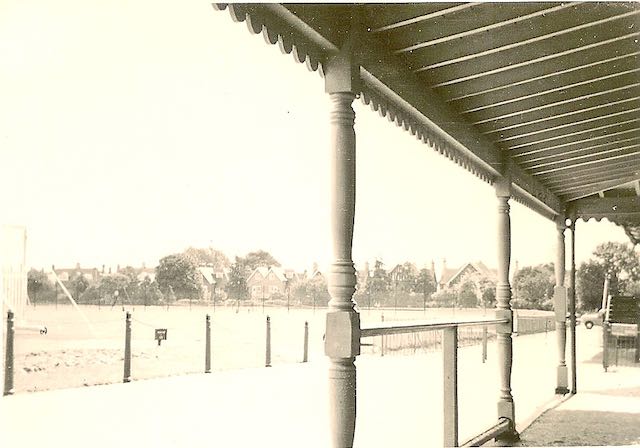
This is the only image I have discovered of the refreshment kiosk overlooking the cricket ground,
with the steps of the cricket pavilion seen through the end of the kiosk's verandah.
COURTESY BETTY EWENS

A popular refreshment chalet next to the welcoming shade of a mature tree (red circle), occupied a grass triangle between the cricket ground and football pitch.  That little building has also been removed, leaving no refreshment facility in the park.  The Council built public toilets at the Crown boundary.  That was back in the 1920s.  The only other, rather rudimentary, facilities are near the football pitch and the bowling green, the latter available with a RADAR key.  For many years these have remained the only facilities  since the Council leased the Crown toilets to a restaurant business.  

Anyone enjoying the Park in 1946 and returning today would discover remarkably few changes.


Sunday, 12 June 2022

The Rec in 1946

 Just when you think you know a place well, along comes a fresh element about which you had no previous knowledge.  Or almost no knowledge; but more of that shortly.

The map below covers the same area as this 1946 aerial photograph taken by the RAF.  
Hatfield Road crosses the bottom of the picture. Fleetville Recreation Ground (Fleetville
Park is left centre with Fleetville School to its right.  In the top section roughly west to east is
Burnham Road and lower Brampton Road.
COURTESY HISTORIC ENGLAND

In the previous post you will be aware of a series of RAF aerial photographs taken in 1946 and now available to view on the Historic England website.  In that post we explored The Park.  This week I've chosen to home in on part of the very heart of Fleetville: the Recreation Ground, Fleetville Infants School, and Royal, Woodstock, Burnham and Hatfield roads.  The aim is to contrast today's  topography with that of 1946.  In so doing we have to manage an image of high contrast created by the bright sunshine and deep long shadows on the day of the flyover.

The map covers the same area as the aerial photo.
COURTESY OPEN STREET MAP CONTRIBUTORS


The very recognisable range of pitched roofs of Fleetville School, which were two distinct buildings in 1946, with a playground space between the junior and infant departments, is now, one joined structure and also enlarged at the northern end (the old Boys entrance of elementary school days).  The wooden Hut, consisting of two classrooms, arrived in 1938 is now replaced by a large modern hall on the Woodstock Road South side, and the long narrow structure further north along the same boundary were the outside toilets.  Although these have now gone the high boundary wall still exists as a kicking wall.  The space south of the former Hut consisted of a garden for the adjacent police station and house (shown as car park P on the map) just behind the Post Office.

Fleetville School (Infant School today) with the wall on the right.  Behind this was once the outside toilets.

Turning our attention to the Recreation Ground (Fleetville Park on the map), a temporary building had been constructed just behind Royal Road in 1942.  It was a day nursery for the young children of employees at the munitions works in Hatfield Road (Fleetville Community Centre and Morrisons on the map). The bright fresh concrete slab on which the building was placed shone out in 1946. Just visible on the Royal Road side of the building was where the embankment down to road level had been partly cut away with a concrete ramp leading down to underground tunnel shelters; the building had been placed on top of the tunnels cut in 1938 and 1939. The ramps have now been levelled to create the present car park in front of the community centre.

The rear elevation of the Community Centre


Wartime street shelters constructed in the roadway.  This example is from Manchester.
COURTESY MANCHESTER LIBRARIES


This leads us to a recollection given to me a few years ago; a resident recalled when he was a child that "a few" street shelters were constructed in the roadway of Royal Road.  I searched in vain for confirmation but found none – until now, for the RAF photo taken in October 1946 clearly shows six structures on the footpath and half of the roadway outside the nursery building.  They must have been demolished and removed in 1948 for I do not remember them.

Residents wishing to see the (temporary) community centre building will need to be quick; it is expected the building will be demolished in July of this year, in preparation for a new building to go up in its place.

An emergency water tank similar to, but much smaller than the one, on Fleetville Recreation
Ground.  This example is from Aston, Birmingham.
COURTESY BIRMINGHAM CITY ARCHIVES

The rectangular structure near the Hatfield Road boundary was an emergency water storage tank for the National Fire Service, clearly emptied for safety, next to which was the ARP hut.  Here is this week's question: halfway along the diagonal footpath between Hatfield Road and Royal Road is a circular shape.  Although I can identify the children's swings to the right of it, was there a revolving ride, such as a roundabout or witches' hat?  I remember neither of those, only the swings.  Anyone with further information please contact. 

On the south side of Hatfield Road, far from straight, near the southern edge of the photo are the long parallel roofs of the former Fleet Works, the Smith's Printing factory, by 1946 being used as Ballito hosiery mill.  Immediately to its left is a narrow grey-looking site with seasoning sheds to the left, which today is part of the surface parking for Morrison's.  But in 1946 was a busy timber yard owned by the Lavers family.  Recognisable by its shape is the outline of the former Central School, now Fleetville Junior School, today little altered from its original form.

The timber yard of W H Lavers, Hatfield Road, now under the car park of Wm Morrison's 
supermarket.  The site was a busy one both for building companies, general contractors and
homeowners.
COURTESY ST ALBANS MUSEUMS


The north-south road to the west of the Recreation Ground is Harlesden Road, one of the many
parallel roads which helped to swell the population of Fleetville from the early 20th
century.  This is Harlesden Road, from the Hatfield Road end, taken around 1914.
COURTESY ST ALBANS MUSEUMS


Many photos of Bycullah Terrace are taken from the western end.  So, just for a change
here is a picture taken from the Sutton Road corner about ten years ago.

Back on the north side of Hatfield Road is the eastern end of the Slade building estate of the early 20th century; the compact terraces and semis of Harlesden, Burnham, Brampton and Woodstock roads, and the two long terraces of Arthur Road.  It is disappointing the deep shadows cast by the Ballito factory hide all of the detail of the most interesting section of Hatfield Road at Bycullah Terrace – Fleetville Shops. 

If you live, or your family lived, anywhere on this photo you will pick it out immediately.  Fleetville was, and still is, a busy suburb of the city.  Until the previous year, 1945, it still hummed with the young voices of children who had become honorary guests of St Albans, having been evacuated here from London boroughs and the Sussex coast.  Let's remind ourselves: this was seventy four years ago.