Sunday 26 April 2020

Middle of the Road

While most people are not leaving home to attend their work places, and the rest of us are venturing beyond the front door only to exercise or buy food, a new adventure, of sorts, has quickly grown, mainly out of necessity: walking in the road space.  Unless an oncoming pedestrian looks ahead and waits at a corner or pauses in an open driveway, we may be forced to take the lead and venture into the nearside road lane.  The opportunities are even there on normally busy roads, and the author has even spent the best part of an hour walking in the road and met no more than five or six cars.

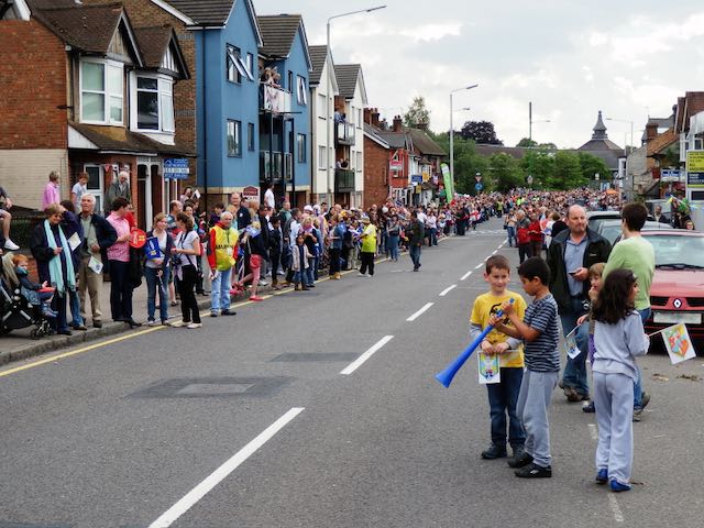
Waiting for the Olympic Torch Relay in 2012; an excited throng along a quiet Hatfield Road.

Co-incidentally, in creating material for a local digital newsletter a month ago I made mention of an advance notice by the BBC that it intends to build a programme of London 2012 Olympic events, including running the full opening ceremony from the Olympic Park.  There is, of course, plenty of room in the schedules since the postponement of the Tokyo Olympics.  In the newsletter I reflected on one part of 2012 which most closely involved the East End of St Albans, which was the Torch Relay.  So we remember that joyous day along Hatfield Road, when, after the road closure and before the torch bearers passed westwards towards the city centre, a number of us walked casually in the middle of Hatfield Road, paused, chatted, even sat down, the latter just because we could!  I mused that such a chance would probably never again be experienced by any of us without putting ourselves in danger.  I wrote it at the time of the event, and I repeated it for the recent newsletter, but as soon as the words were on the page, the reality of a repeat opportunity was suddenly created, even for short bursts of time in Hatfield Road.

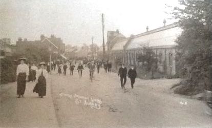
A busy Hatfield Road c1910, Fleetville, but not a motor vehicle in sight.

Probably the earliest surviving photograph of Hatfield Road, Fleetville has come to rare notice, partly because of the inferior quality of the image.  In spite of this it tells of a busy period of day outside the printing works, now replaced by Morrison's.  It can be dated to around 1910, as the County Council had carried out paving the length of Hatfield Road in that year.  But the numbers of residents or employees casually walking in the roadway, with no more danger than from passing cyclists, suggests the arrival of a motor vehicle was still a rare event.

The same view over 100 years later, with the print works building replaced by a supermarket.
COURTESY GOOGLE STREETVIEW


Being less confident than the 1910 photographer the author left it to a Google Streetview vehicle driver to capture a recent photograph taken roughly at the roundabout giving access to Royal Road in one direction and the Morrison's car park in the other.  This is where the 1910 photographer would have stood.  Royal Road would be just out of sight to the left of the picture and a gateway leading to spare land owned by Smith's printing works just to the right of the tree at the right edge.  This gateway would later be the entrance to Marconi Instruments Fleetville.  Behind the two hatted ladies closest to the photographer were trees and shrubs on spare land behind the lay-by in the modern picture, and a shop blind reveals the location of Bycullah Terrace.  The only other difference were the tall trunk telephone wire poles which marched their way along Hatfield Road on their way to Hatfield; today the wires are protected in trunking and lie beneath our feet.

It would not be long before the number of vehicles of all kinds grew in number along this road, sufficient to encourage and then force us to walk along the footpaths, but it would be another twenty years from the first photo before such a path was laid on the south side – there were no shops here.


Saturday 18 April 2020

Wretched Road Charges

The oft-quoted complaint by most householders, whether tenants or owners, at some point after moving into a new house before the 1950s.  Streets were laid out; water and gas mains laid – electricity and drainage only later – and homes constructed. Each owner was deemed to be responsible for the footpath and road for up to half of its width.  No-one was happy about purchasing a corner plot since that meant, when the time came for the rest of the road infrastructure to be laid, surfaced and lit, you paid twice.  Councils, which ended up carrying out these improvement works, would only agree to do so once most of the homes had been finished and occupied; possibly a period of several years or even decades.  The cost was not intended to be a charge on the rates (now replaced by council tax) and each householder received an invoice from the council for the wretched road charges – sometimes referred to at the time as private street works.

All such streets were considered private, owned jointly by its occupiers or landlords, until such time as the council had sufficient funds to carry out the work with a good chance of being recompensed through special loan schemes; the sums involved were not inconsiderable.  In the meantime, residents put up with the inconvenience of dust, mud and potholes, sometimes for several years.  The photo of a community group from Woodland Drive agreeing to carry out some of the more serious work was not unusual; it was, after all their road.

When residential development took place without regard to overall responsibility for drainage, adding more and more buildings and hard surfaces also added flooding risk.  Between the northern and southern halves of previously Spencer-owned land lies Brampton Road and its downhill gradient from the park end to Woodstock Road.  Before the houses went up surface water in periods of heavy rainfall would have found its way towards the former ancient  stream bed just east of the Woodstock Road homes, eventually finding its way to the Ver, the Colne and the Thames.

Hamilton Road today
COURTESY GOOGLE EARTH
When the water can't soak into the ground or run away safely, it might hang around in puddles and lakes, such as at the southern end of Hamilton Road.  Memories are recalled of women walking to the route 354 bus stop in Brampton Road with a spare pair of wellington boots for husbands returning from the station.  All part of the well-rehearsed wet weather routine.

In fact so long did the Hamilton Road residents have to wait that the earliest had lived there for over twenty-five years; by which time the road had been torn up to lay larger drainage pipes all the way to Campfield Road.  

Since the road was their pride the householders agreed to purchase a few small street trees.  An early attempt to take the same approach to paying for street lights [the editor knows what it was like growing up in a dark estate devoid of lighting] was more difficult to resolve, since the largest cost was in laying the cables, so a start was made from a connection from Jennings and Brampton roads; the long middle section was still dark!

A Sunday morning road mending session; Woodland Drive north in the
early 1950s
COURTESY HERTS ADVERTISER
Experiences of living in dust, mud, floods and darkness are repeatedly told in the St Albans' East End, from Camp and Fleetville, Oaklands, Marshalswick and Beaumonts, and along Hatfield Road too. The adventure living on this side of the city pervaded well into the 1960s.

Today, house builders have to do more than build homes; they must comply with standards set by regulatory bodies and local authorities, and carry out road construction, public lighting, cycle and pedestrian routes, and of course community open space, before the council signs off the development and agrees to adopt the road(s), street plates included.  Aren't we lucky?  Maybe, but that's what we have paid for.  People today moving into Osprey Drive and Austen Way won't be enduring the same fun as those from Royston Road, Meadow Close and Hamilton Road in their time. 

Sunday 5 April 2020

Bigger and More Proud

Eighteen seventy-seven: it turned out to be a significant year in the history of St Albans, as the Abbey became a Cathedral (formally known as the Cathedral and Abbey Church of St Alban) and a Bishopric.  The Council then successfully applied for the Monarch, Queen Victoria, to confer the status of city on for St Albans.

Co-incidentally (or not) in the same year the rather rural sounding  Sweetbriar Lane was changed to become Victoria Street from the Town Hall to the city boundary, which since 1835, had been set at Lattimore Road from its previous limit near Marlborough Road.  No markers exist to show where these limits were.

1879 boundary post at Bluehouse Hill.
In 1877 the Herts Advertiser published details of the number of residents.  8,303 lived within the borough (the 1835 limits), 11,000 in the wider town – from the Market Cross to one mile distant.  So around 3,000 people resided beyond the city limit although would have relied of the services of the city and its council for various aspects of their lives.  The time had therefore come to apply for the extension of the boundary to approximately three-quarters of a mile.  Eastwards that created a new limit along Hatfield Road at  Albion Road.  This extension was granted in 1879 and for such a historic occasion the new Council had boundary posts manufactured, most of which remain today.  The wording proudly reflects the new status of the borough as a city.  Below the crest are the words CITY OF ST ALBAN 1879.  The town's name used to be written with an apostrophe (St Alban's) but today this is universally omitted.

1913 post in Sandpit Lane:
date label not quite level
Even in 1879 houses were being built beyond the boundary and the council therefore found itself in a similar position in 1913 when an application to take in new added areas as far as Oaklands was successful.  On this occasion new posts were set up with the same wording but with the year 1913 inside a rectangular panel, this panel having been added to the posts after casting, and not always in exactly the same position.  On the Sandpit Lane post it not quite horizontal.

1913 post at Hill End Lane

A much smaller boundary extension took place in 1935 but no dated boundary posts were produced.

The responsibility for looking after the markers rests with the local authority, but inevitably they end up being treated like lamp posts, road signs and other items of street furniture in being neglected.  The boundary posts are also prone to being hidden in undergrowth and shrubs, including ivy.  If the city was proud of them and their function when first installed, perhaps we should all feel a little bit proud of them today.  Maybe the council will permit volunteers to renew the paintwork with approved products and colours.  Just a suggestion.