Showing posts with label Woodstock Road. Show all posts

Sunday, 5 February 2023

Nine

 When growing up in the 1950s, I came across grown-ups who were well settled into their Fleetville lives (as a child I would have used the word 'old') referred to a non-specific part of the district as Nine Fields, or the Nine Fields.  It has taken decades to home in on the background to this name.

Sear & Carter, who had a garden shop and nursery in Hatfield Road, on the site of today's St Paul's Place, had named it Ninefields Nursery.  So likely it was close by to this group of open space fields.

A class of boys from Hatfield Road Senior Elementary School at work with their teachers on
the land north of Brampton Road in 1917.  Early work to prepare wartime allotments for their
families.  The south side of Brampton Road is in the background.
COURTESY HERTS ADVERTISER


The beginning of the article which accompanies the
photograph above it.
COURTESY HERTS ADVERTISER


Frank Sear (before becoming Sear & Carter) advertised its Hatfield Road shop and adjacent land
as Ninefields Nursery.  The nine fields, however, were north of Brampton Road.

The Herts Advertiser in 1917 ran an article about senior school pupils who had taken on extensive plots of ground "at the Ninefields" for wartime allotments.  The boys (the item was specific here; no girls were mentioned) would take home produce which they grew to their families. In one of the earliest photographs published in the paper the image was spread over the whole width of the page but there was little height to it.  The photographer was probably standing close to where Jennings Road is today, facing south so as to capture large numbers of boys at work, with the south side of Brampton Road beyond.

An uncle, who had grown up in one of those Brampton Road terrace houses, recalled his childhood adventures playing "on the Ninefields at the Woodstock Road end".

With a copy of the 1840 tithe map in front me I annotated that section between Beaumonts and the then city boundary and between Hatfield Road and Sandpit Lane.  Unfortunately I didn't manage to join the split map very effectively. 

The field names might, I thought, provide a clue to the name Nine Fields.  Descriptive as they were, the field names led me no nearer to an answer (except for one field named Nine Acres!)  Perhaps I should look at field names in more detail.  One group focused on locations and general descriptions of shape, such as Further Field or Great Long Field.  A pair of the largest fields in the Sandfield Road/Verulam School area was named Great Moodys and Long Moodys, which suggests an old English reference to fields which are difficult to work, unless someone has a more specific suggestion.

The orange labelled fields belonged to William Cotton of St Peter's Farm. The
unlabelled fields on the left are part of the map below.  Kinder's fields of
Beaumonts Farm and the Grammar School Field, on which Fleet Ville was
built, is not part of this survey.
TITHE MAP COURTESY HALS
A third group defined the fields in terms of their size in acres; there is Four Acres, Seven Acres and so on.  I noted that the group 1 and group 2 fields in 1840 were both owned by William Cotton of St Peter's Farm, whose farmhouse still exists as the Conservative Club, near The Crown.  Group 3 fields all belonged to Earl Spencer.  There were twenty fields in total.  Mr Cotton's apportionment was eleven fields, including the smallest, the almost circular Dell Field, a former chalk pit.  However, Spencer's total was 9 fields – so, to spell it out, Nine Fields.

The green labelled fields belonged to Earl Spencer; the orange labelled
fields belonged to William Cotton of St Peter's Farm and are additional
to his fields on the top map.  The two unlabelled fields lower right appear
on the top map and are labelled on that version.
TITHE MAP COURTESY HALS
The Nine Fields were a contiguous group, all north of Brampton Road, six of them with a boundary to Sandpit Lane and the remainder completely road-locked but edged by the lengthy footpath between Hatfield Road/Beaumont Avenue and St Peter's Church, much of which was adopted by Brampton Road and York Road.

So, although the Nine Fields must have been a specific group which did not include fields in the vicinity of Woodstock Road, it seems that the name became more generalised to refer to all of the fields between Brampton Road, Woodstock Road, Sandpit Lane and Clarence Road; quite possibly a slightly larger area before early 20th century developments.

References to Nine Fields in published works are virtually absent – but then, very little about the eastern districts of St Albans has been published anyway.  If, however, readers of this blog are in possession of more definitive information, please to share it with us.

Sunday, 19 December 2021

The End of Our Road

 Recently I rediscovered a postcard photograph from circa 1914  showing off an almost new Glenferrie Road.  The street looked smart!  The photographer had set up his tripod in the middle of the road, probably halfway along the road, and his camera faced towards Hatfield Road.  The only sign of life captured was a road sweeper with his barrow, and I noted how wide the public space appeared to be; no parked cars, of course, and the footpaths were equally clear of rubbish bins, skips, data connection boxes, parking signs or  telephone wires carried on their sturdy posts.  And no white lines on the roadway or coloured spray paint on the pavement.  Litter? Not a wrapper to be found.  In this view just one small street light is  visible, and, if you look carefully, one posting box on the corner where the future Methodist Church will be built.

Many more pedestrians would have been be walking in one direction or the other, and as this photo was facing Hatfield Road, everyone's major view was about twenty feet of the south side of Hatfield Road unhindered by today's obstructions; the growing trees of the cemetery and a field tree predating the cemetery but now removed.  This was a fixed and identifiable scene with which householders were familiar.  East street end had, and still has, is own unique borrowed picture of the next road.  Unfortunately, similar photographs are not available of all of Fleetville's roads, and although today's roads are crowded I thought it might be useful to find Streetview images of nearby residential roads and focus on their own end of road fixed views.


The widest view presented to us is in Clarence Road just south of the park's main entrance; a view not much changed since 1900 – The Crown and the Stanhope Road shops.  Only the former post office, now Chilli Raj, is slightly newer.


Laurel Road may be short but provides same amount of view: Rose Cottage (the one with the cart drive under part of the house) and the first of the three Horndean Cottages just before Cavendish Road.


By the time we reach Blandford Road, the view is one of the views which include mature trees. We just miss seeing the main entrance to the cemetery, and just behind the frontage wall and trees is the entrance to the Manager's lodge.  Blandford Road emphasises the difficulty of cars passing each other while parking occupies both sides of the road and two-way working.

Glenferrie Road today, as one hundred years previously, provides us with a green backdrop to Hatfield Road, being at the eastern end of the cemetery.  The trees have grown more majestic and there are no buildings behind to be masked.  It can't of course be helped that this was the day the bins were collected.  Nevertheless most of the containers remain on the footpath all day and make it difficult for pedestrians generally, those in buggies and with sight or other mobility issues, to negotiate a route between garden walls and kerb-parked cars.


At Sandfield Road we are able to look across to the drive of Rainbow House, formerly the Family Centre, and the frontage of Magnet Kitchens.


The former Hobbs Garage comes into view at the end of Harlesden Road.  These days it belongs to Kwik Fit, of course. And we can just see part of the caretaker's house which was erected c1935 for the Central Girls' School, part of the roof of which can be spotted above the Kwik-Fit building.


An especially green south of Hatfield Road is apparent opposite Royal Road where the backdrop of Morrison's car park is Alban Way.  We are led to this view via the welcome tree lined recreation ground.


A hedge-line borders Woodstock Road south at Fleetville Nursery and Infants School and contrasts with the first of two views of Morrison's supermarket, which is probably a more pleasant streetscape than that of the former Thomas Smith printing works structure (also retained by Ballito Hosiery Mill).  Many would consider that building to have appeared more austere.


Finally, from way down Arthur Road we capture the glazed wall of  Morrison's cafe.  We are also deceived by the sight of a tree which looks as if it is growing on the corner site of the old Institute building, although it is a borrowed view; it is growing in the grounds of Morrison's, near the corner of Sutton Road.  We finish with a 1953 monochrome photograph showing the earlier view from Arthur Road across to the Ballito building.  We can colour it in our imagination as we prepare for our 1953 Coronation street party.

We can, of course, find views from the ends of almost every road in the city.  What connects the selection shown above is of course the busy Hatfield Road.

Photos courtesy St Albans Museums and Google Streetview.


Saturday, 18 April 2020

Wretched Road Charges

The oft-quoted complaint by most householders, whether tenants or owners, at some point after moving into a new house before the 1950s.  Streets were laid out; water and gas mains laid – electricity and drainage only later – and homes constructed. Each owner was deemed to be responsible for the footpath and road for up to half of its width.  No-one was happy about purchasing a corner plot since that meant, when the time came for the rest of the road infrastructure to be laid, surfaced and lit, you paid twice.  Councils, which ended up carrying out these improvement works, would only agree to do so once most of the homes had been finished and occupied; possibly a period of several years or even decades.  The cost was not intended to be a charge on the rates (now replaced by council tax) and each householder received an invoice from the council for the wretched road charges – sometimes referred to at the time as private street works.

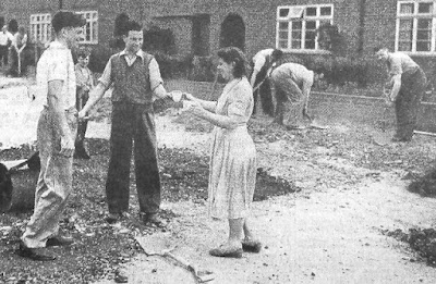
All such streets were considered private, owned jointly by its occupiers or landlords, until such time as the council had sufficient funds to carry out the work with a good chance of being recompensed through special loan schemes; the sums involved were not inconsiderable.  In the meantime, residents put up with the inconvenience of dust, mud and potholes, sometimes for several years.  The photo of a community group from Woodland Drive agreeing to carry out some of the more serious work was not unusual; it was, after all their road.

When residential development took place without regard to overall responsibility for drainage, adding more and more buildings and hard surfaces also added flooding risk.  Between the northern and southern halves of previously Spencer-owned land lies Brampton Road and its downhill gradient from the park end to Woodstock Road.  Before the houses went up surface water in periods of heavy rainfall would have found its way towards the former ancient  stream bed just east of the Woodstock Road homes, eventually finding its way to the Ver, the Colne and the Thames.

Hamilton Road today
COURTESY GOOGLE EARTH
When the water can't soak into the ground or run away safely, it might hang around in puddles and lakes, such as at the southern end of Hamilton Road.  Memories are recalled of women walking to the route 354 bus stop in Brampton Road with a spare pair of wellington boots for husbands returning from the station.  All part of the well-rehearsed wet weather routine.

In fact so long did the Hamilton Road residents have to wait that the earliest had lived there for over twenty-five years; by which time the road had been torn up to lay larger drainage pipes all the way to Campfield Road.  

Since the road was their pride the householders agreed to purchase a few small street trees.  An early attempt to take the same approach to paying for street lights [the editor knows what it was like growing up in a dark estate devoid of lighting] was more difficult to resolve, since the largest cost was in laying the cables, so a start was made from a connection from Jennings and Brampton roads; the long middle section was still dark!

A Sunday morning road mending session; Woodland Drive north in the
early 1950s
COURTESY HERTS ADVERTISER
Experiences of living in dust, mud, floods and darkness are repeatedly told in the St Albans' East End, from Camp and Fleetville, Oaklands, Marshalswick and Beaumonts, and along Hatfield Road too. The adventure living on this side of the city pervaded well into the 1960s.

Today, house builders have to do more than build homes; they must comply with standards set by regulatory bodies and local authorities, and carry out road construction, public lighting, cycle and pedestrian routes, and of course community open space, before the council signs off the development and agrees to adopt the road(s), street plates included.  Aren't we lucky?  Maybe, but that's what we have paid for.  People today moving into Osprey Drive and Austen Way won't be enduring the same fun as those from Royston Road, Meadow Close and Hamilton Road in their time.