Showing posts with label Clarence Road. Show all posts

Sunday, 19 December 2021

The End of Our Road

 Recently I rediscovered a postcard photograph from circa 1914  showing off an almost new Glenferrie Road.  The street looked smart!  The photographer had set up his tripod in the middle of the road, probably halfway along the road, and his camera faced towards Hatfield Road.  The only sign of life captured was a road sweeper with his barrow, and I noted how wide the public space appeared to be; no parked cars, of course, and the footpaths were equally clear of rubbish bins, skips, data connection boxes, parking signs or  telephone wires carried on their sturdy posts.  And no white lines on the roadway or coloured spray paint on the pavement.  Litter? Not a wrapper to be found.  In this view just one small street light is  visible, and, if you look carefully, one posting box on the corner where the future Methodist Church will be built.

Many more pedestrians would have been be walking in one direction or the other, and as this photo was facing Hatfield Road, everyone's major view was about twenty feet of the south side of Hatfield Road unhindered by today's obstructions; the growing trees of the cemetery and a field tree predating the cemetery but now removed.  This was a fixed and identifiable scene with which householders were familiar.  East street end had, and still has, is own unique borrowed picture of the next road.  Unfortunately, similar photographs are not available of all of Fleetville's roads, and although today's roads are crowded I thought it might be useful to find Streetview images of nearby residential roads and focus on their own end of road fixed views.


The widest view presented to us is in Clarence Road just south of the park's main entrance; a view not much changed since 1900 – The Crown and the Stanhope Road shops.  Only the former post office, now Chilli Raj, is slightly newer.


Laurel Road may be short but provides same amount of view: Rose Cottage (the one with the cart drive under part of the house) and the first of the three Horndean Cottages just before Cavendish Road.


By the time we reach Blandford Road, the view is one of the views which include mature trees. We just miss seeing the main entrance to the cemetery, and just behind the frontage wall and trees is the entrance to the Manager's lodge.  Blandford Road emphasises the difficulty of cars passing each other while parking occupies both sides of the road and two-way working.

Glenferrie Road today, as one hundred years previously, provides us with a green backdrop to Hatfield Road, being at the eastern end of the cemetery.  The trees have grown more majestic and there are no buildings behind to be masked.  It can't of course be helped that this was the day the bins were collected.  Nevertheless most of the containers remain on the footpath all day and make it difficult for pedestrians generally, those in buggies and with sight or other mobility issues, to negotiate a route between garden walls and kerb-parked cars.


At Sandfield Road we are able to look across to the drive of Rainbow House, formerly the Family Centre, and the frontage of Magnet Kitchens.


The former Hobbs Garage comes into view at the end of Harlesden Road.  These days it belongs to Kwik Fit, of course. And we can just see part of the caretaker's house which was erected c1935 for the Central Girls' School, part of the roof of which can be spotted above the Kwik-Fit building.


An especially green south of Hatfield Road is apparent opposite Royal Road where the backdrop of Morrison's car park is Alban Way.  We are led to this view via the welcome tree lined recreation ground.


A hedge-line borders Woodstock Road south at Fleetville Nursery and Infants School and contrasts with the first of two views of Morrison's supermarket, which is probably a more pleasant streetscape than that of the former Thomas Smith printing works structure (also retained by Ballito Hosiery Mill).  Many would consider that building to have appeared more austere.


Finally, from way down Arthur Road we capture the glazed wall of  Morrison's cafe.  We are also deceived by the sight of a tree which looks as if it is growing on the corner site of the old Institute building, although it is a borrowed view; it is growing in the grounds of Morrison's, near the corner of Sutton Road.  We finish with a 1953 monochrome photograph showing the earlier view from Arthur Road across to the Ballito building.  We can colour it in our imagination as we prepare for our 1953 Coronation street party.

We can, of course, find views from the ends of almost every road in the city.  What connects the selection shown above is of course the busy Hatfield Road.

Photos courtesy St Albans Museums and Google Streetview.


Thursday, 14 October 2021

Clarence Conservation

The previous post highlighted the details of Sleapshyde's Conservation Area and Character Statement, which is one of only three in the eastern districts out of 27 within the St Albans District.

The Midland railway marks the western boundary of the Clarence
Road Conservation Area and Clarence Road winds its way north-
south on the eastern side.  The houses which are coloured green
are locally listed.
COURTESY ST ALBANS DISTRICT COUNCIL


Today I am turning my attention to the Clarence Park Conservation Area (CA) and Character Statement (CS).  The zone is bounded by the Midland Railway, Hatfield Road, the rear of properties on the eastern side of Clarence Road (both lower and upper), and Sandpit Lane.  Many of us enjoy spending time in Clarence Park itself and we will often catch glimpses of houses which line Clarence and York roads, though we may be less familiar with Blenheim Road, upper Jennings Road and Gainsborough Avenue – although the latter contains no locally listed houses to form part of the collection.  Finally, there are four identified structures within Clarence Park, although one of these, Verdi's restaurant, is technically not within the park, a point I will briefly return to later.

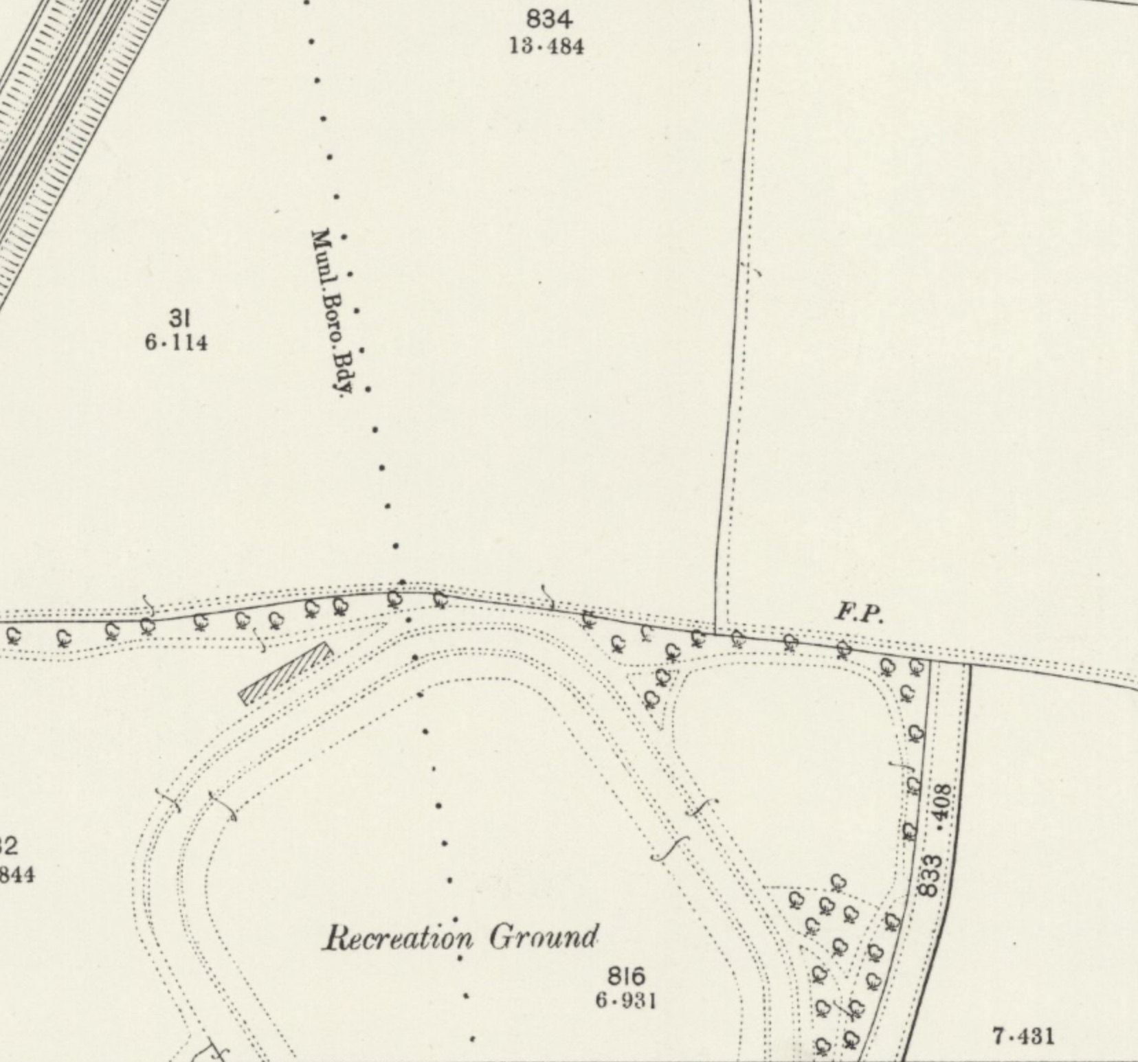
The 1897 OS map shows the recently laid-out Clarence Park together with lower Clarence Road
prepared as far as what will shortly become York Road along the line of the footpath (FP).
At this point no work has begun on the Spencer estate, nor Brampton Road.
COURTESY NATIONAL LIBRARY OF SCOTLAND

The Statement briefly confirms the area's history as land belonging to St Peter's Farm which had been owned by William Cotton (who was not referred to) before being partly taken for railway construction and the remainder acquired by Earl Spencer.  The park was formed from two tranches of land: the former fete field, which became the pleasure park and is the area adjacent to Hatfield Road; and the section purchased by Sir John Blundell Maple specifically for a cricket field and other active pursuits.  Only the latter is referred to in the CS, but the fete field was used by members of the public long before the formation of the park in 1894.  Lower Clarence Road and York Road were adapted road layouts which, together with the railway and Hatfield Road, were intended to envelope the park.  Earl Spencer added to this his residential estate reaching Sandpit Lane, the western part of which lies in the northern part of the CA.

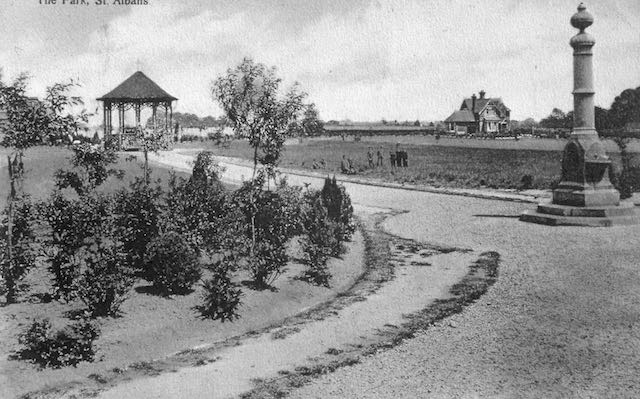
The freshly laid-out pleasure park, the former fete field, with the drinking fountain donated by
Lady Maple, the first bandstand, and, in the background is shown the park keeper's lodge.
COURTESY ST ALBANS LIBRARIES (HALS)


The cricket pavilion and changing rooms.

Probably the main reason the park remains within this CA is its largely unaltered layout.  It is heralded as an untouched Edwardian open space with the lodge and cricket pavilion both recognised in the CA as original features; also the later-added pay kiosks and earliest football club rooms, the water fountain donated by Lady Maple which was installed soon after the park's opening; all are identified as locally listed.

The only structure which does not fall into the above categories is the building, formerly public toilets for The Crown local area, used today as Verdi's restaurant.  This is no longer in the park as the boundary fence was moved northwards in 1928 to provide extra visibility to avoid a potentially dangerous blind spot for vehicles emerging from Clarence Road. A short time later public toilets were built in this space which reduced some of the visibility earlier gained!

A group of the houses overlooking the park at the Hatfield Road end of lower Clarence Road.

Numbers 4 to 30 Clarence Road, as well as Alexandra House, are the first group to be locally Listed and the cottages fortunately have unaltered frontages. Alexandra House is the former Barclay's Bank and chemist shop when first opened.

Two pairs of large semi-detached villas just north of the park entrance in lower Clarence Road.

Many of the remaining semi-detached houses in lower Clarence Road and overlooking the park are described as Queen Anne/Domestic Revival style.  They are substantial and so similar but not identical, which prompts the question of their design.  The CS suggests there were at least three architects at work here: Percival Cherry Blow, Henry Hansell and Henry Mence, but others may have also been part of the practices.

An arts-and-crafts style house in upper Clarence Road.
COURTESY GOOGLE STREET VIEW

Most of the homes in upper Clarence Road are all on the list even though they were built in a variety of styles. Newer infill properties have been excluded.  However an arts and crafts corner house with a lych gate and well-protected with hedging, is feature at the Jennings Road corner.  A plot on the western side of upper Clarence Road which has remained undeveloped for over one hundred years is, for the first time, being built on and will probably become the largest house in the CA.

Houses in York Road were built between c1906 and the mid-1930s and all face Clarence Park.
COURTESY GOOGLE STREETVIEW

Most of the York Road homes, which are detached, are locally listed with the exception of three at the railway end which are later additions to the streetscape.  The much-changed house on the corner of Clarence Road which has been used as a nursery is not included on the list.

A house standing on a Blenheim Road corner.


A house standing on a  corner of Blenheim and Jennings roads.
COURTESY GOOGLE STREETVIEW

A similar plot of land in Blenheim Road was developed a few years ago (Sefton Close) following the demolition of a property.  Otherwise almost every house in Blenheim Road is locally Listed.

There were one or two surprising omissions in upper Jennings Road, which result from later building even though the designs appear to be well-proportioned and similar in design to nearby Listed homes.  The south side of the road was built from the 1930s and clearly does not merit Listing.  Gainsborough Avenue, which was also much later, contains no Listed properties along its frontages.

Wednesday, 27 May 2020

Laurel

The ladder roads on the north side of Hatfield Road, those between Harlesden and Blandford, are well-recalled by name, but there one other less well remembered street, although it leads nowhere except the ends of one or two Clarence Road rear gardens.  This is Laurel Road, one of those development roads which was intended to squeeze in a few extra small homes in an awkwardly shaped section of the site close to St Peter's Farm.  Although there is no remaining evidence for the street name, it is possible to search for it.  All we need is to return to the period prior to the development in the late 1890s.


Hatfield Road passes the farm in 1872.  Clarence Road will later be laid just
to the left of the pond; the shrubbery is to the right of the farm buildings.
COURTESY NATIONAL LIBRARY OF SCOTLAND
So clear all homes and shops from your mind – even the 1880s Cavendish estate. Stand, in your imagination, at the top of the hill in Hatfield Road and look down  towards what is now The Crown junction.  Here was yet another broad stream valley with its lowest ground from right to left into Camp Road.  Apart from a tiny turnpike toll building only one pair of buildings would be visible: St Peter's Farm and the adjacent St Peter's Farm Cottage.


Laurel Road c2012.  The houses in the background front onto Clarence Road.
They are still there in the form of the Conservative Club and Clarence Mews, the latter being a gated conversion of former farm outbuildings accessible from Clarence Road, opposite the main park entrance.  The farm buildings are not ancient in the sense of most farm homesteads; it appears that this was a farm holding created in the early 19th century.  But when built the land owner still felt it important to lay the homestead foundations on slightly elevated  ground on the eastern side of the valley referred to above – today we walk this valley side in front of the shops from the Crown corner towards Laurel Road.

With a change of tenancy in 1878 the farm buildings were advertised on the farm estate plan, along with its fields.  When the farm was sold in the late 1890s, there remained two homes available to sell or let which were already there, the farm and farm cottage.  The opportunity was taken to provide a name for this pair, and so they became known as Laurel Bank after the shrubs and trees growing behind the farm, as shown in the 1872 map.  It is from this landscape feature that the little road at the top of the valley side was named.
Estate map St Peter's Farm, 1878.  The owner has named the farm Ardounie
COURTESY HALS

The street directories at the time show that the first occupants were Mr G Mead (farm) and Mr H Pearce (cottage), but they was quickly followed by Edward Hansell, an architect and surveyor.  It is therefore possible that Mr Hansell was involved in the residential developments then being laid out along Hatfield Road.  Once most of the estate had been completed Laurel Bank became available once more and Mr Raymond Nelson, a draper and outfitter, lived and traded from the premises until the Conservative Club acquired the former farm c1946.


Hatfield Road in lower part of view; Clarence Road upper left; former farm and cottage behind the hedge in Hatfield Road.
Former outbuildings converted into a square Mews arrangement.  Laurel Road on right.  Former shrubbery between the
farm and Laurel Road.
COURTESY GOOGLE EARTH


While that may explain the naming of Laurel Road and its connection with the former farm, there is another name which is revealed in the 1878 farm estate map.  For while the Ordnance Survey map from six years earlier labels the buildings as St Peter's Farm, the farm estate map identifies the homestead as Ardounie.  This name is listed in the reference work Fairbairns Crests, although its specific connection with this location is unclear.

Next time we'll explore those homes and shops which filled the space between the newly laid out Clarence Park Road (as originally named) and that little Laurel Road at the top of the hill, passing the old farm on the way.


Saturday, 7 September 2019

Does the shoehorn actually work?

There appear to be two related definitions of the term shoehorn: it is a curved tool to help ease our feet into a tight-fitting shoe, probably an early indicator that a larger shoe size might be appropriate.  Used as a verb, it can also describe forcing something into a space which is really too small.

The north side of Hatfield Road, when first laid out, was a mix of small houses and then increasingly shops.  Living accommodation for the shop owners was in the form of an upstairs flat; house occupiers had a tiny front garden, and both groups enjoyed a small private rear garden.

In time the rear gardens were lost to rear extensions, preparation buildings and stores.  Where possible vehicle access was squeezed in from the side roads.  Even in a nearby residential road a corner property owner has foregone a rear garden in favour of building three accommodations.  Recently, it was revealed that a property in Hatfield Road undergoing alterations was about to add a  similar number of one bed accommodations on the first floor, shoe-horned into  space too awkward and inadequate for the purpose.  And our  residential districts are littered with examples of a jarring streetscape created through unsympathetic and over-sized extensions intended to overfill the plot.


A variety of well-proportioned homes form a backdrop to the open spaces of Clarence Park.

This week St Albans celebrated the publication of a delightful little book about one of the district's foremost architects, Percival Cherry Blow (1873 to 1939).  The book launch was held in one building which he had designed – Thomas Oakley's grocery, now Waterstone's – and followed up with a meal for some at another of his buildings, Ryder's Exhibition Hall, now Cafe Rouge.


A Percival Blow designed house in Clarence Road.

While most of Blow's residential buildings were substantial in size and on good-sized plots, it appears that the architect was as concerned about how the proposed dwelling would sit in the street scene, and so space was as important as the physical structure.

One suspects that if Blow had been called back to add something to  one of his houses he would have given it the same meticulous attention as the original, and would know the limit of what was aesthetically possible on any plot.


Elements of the previous building on the site are captured in the red brick
Rats' Castle public house in Fleetville, designed by Percival Cherry Blow.

In the eastern districts of the city there are examples of his domestic work in Brampton, Blandford and Stanhope roads, and a range of semi-detached and detached houses in Clarence Road.  If such detailing attention is paid to the building elevations themselves it would seem natural to apply the same attention to the street boundaries.  Of course, today this is difficult to achieve as the imperative seems to be to get cars off the road at any cost, a requirement not foreseeable in the period when Blow was practising his profession.


                                                                           SAHAAS


All of us would benefit from a read of the new book, St Albans' Architect Percival Blow, published by St Albans & Hertfordshire Architectural & Archaeological Society.  As we do so we will discover so many more buildings Percival Cherry Blow was commissioned to design; our streetscape is the richer for his endeavour.

Saturday, 10 August 2019

Idyllic Dell

The Sandpit Lane boundary of the former St Peter's Farm remained much as it had done for centuries until the sale of the farm in the 1890s.  One imagines a hedge beside the lane between what today is Clarence Road and Woodstock Road north.  There were fields for grazing cattle, but one little area was always fenced against cattle intrusion and as early as the 1841 tithe map this pocket-sized copse was named The Dell, an apt label given that it was a depression in the landscape.  Today it is a fully mature circular area of mixed woodland.

Might it have been a growing medieval pit for sand extraction?  Or – and this will surely be on your mind – the result of a sink hole?  Whatever its cause, once trees had begun to grow a distinct ecosystem thrived.  There are sporadic reports that access by the public might have been granted to appreciate what had clearly been acknowledged as a very special environment.

Following the sale of the farm it did not take long before Thomas Grimwood purchased a substantial plot of land between the road and The Dell to build himself a house, appropriately named The Dell.  Whether or not Mr Grimwood realised at the time this was the one location along Sandpit Lane where the Wastes were absent with no additional permissions required to gain access to his plot of land.  The plot was in a commanding position right on the edge of the heath.

Before the 1930s Sear & Carter used the lower part of the plot beyond the house and gardens as one of their trial grounds supporting the Ninefields Nursery, now St Paul's Place.

Before and after the First World War others constructed their homes along this part of the lane.  Mr Grimwood sold The Dell  to Mr Fletcher, and he in turn passed it onto Mr Sykes.

Housing had crept closer to The Dell in the 1930s, but not from the lane.  Jennings Road and Churchill Road had been laid out, and eventually the rear gardens of a few of the resulting homes touched the edge of The Dell from the south and west.

But something different occurred in 1965.  The Dell and The Dell became a development opportunity.  Michael Meacher & Partners, architects, and Watford's Kebbell Developments produced plans for groups of flats and houses on the site.  There was never any intention to develop The Dell itself or its approaches.  This may have been for the laudable reason of open space protection in an environmentally special part of the site, but it was also convenient that The Dell was somewhat below the level of the district's sewer and drainage network, with the practicalities of making homes work in those part of the site difficult, if not impossible.


A later phase consisted of two ranges of two-storey homes, although three storey houses had been originally planned.  So the three-bed flats fronting the lane are the only three storey accommodations.

The two open areas are the treescape which can be seen along Sandpit Lane, and The Dell itself, although buildings press hard against its boundary.

Naturally, many nearby residents formally objected to the development scheme.  Perhaps they imagined something hideous, noisy, unsightly or unsuitable for the location.  Certainly the site, as with almost everywhere else in this part of the city, is far more intensively used than when Mr Grimwood was in residence, The Dell is in tact, and therefore the habitat enjoyed. by birds and mammals.  Just as in the centuries when it was part of a farm.