Showing posts with label Royal Road. Show all posts

Sunday, 19 December 2021

The End of Our Road

 Recently I rediscovered a postcard photograph from circa 1914  showing off an almost new Glenferrie Road.  The street looked smart!  The photographer had set up his tripod in the middle of the road, probably halfway along the road, and his camera faced towards Hatfield Road.  The only sign of life captured was a road sweeper with his barrow, and I noted how wide the public space appeared to be; no parked cars, of course, and the footpaths were equally clear of rubbish bins, skips, data connection boxes, parking signs or  telephone wires carried on their sturdy posts.  And no white lines on the roadway or coloured spray paint on the pavement.  Litter? Not a wrapper to be found.  In this view just one small street light is  visible, and, if you look carefully, one posting box on the corner where the future Methodist Church will be built.

Many more pedestrians would have been be walking in one direction or the other, and as this photo was facing Hatfield Road, everyone's major view was about twenty feet of the south side of Hatfield Road unhindered by today's obstructions; the growing trees of the cemetery and a field tree predating the cemetery but now removed.  This was a fixed and identifiable scene with which householders were familiar.  East street end had, and still has, is own unique borrowed picture of the next road.  Unfortunately, similar photographs are not available of all of Fleetville's roads, and although today's roads are crowded I thought it might be useful to find Streetview images of nearby residential roads and focus on their own end of road fixed views.


The widest view presented to us is in Clarence Road just south of the park's main entrance; a view not much changed since 1900 – The Crown and the Stanhope Road shops.  Only the former post office, now Chilli Raj, is slightly newer.


Laurel Road may be short but provides same amount of view: Rose Cottage (the one with the cart drive under part of the house) and the first of the three Horndean Cottages just before Cavendish Road.


By the time we reach Blandford Road, the view is one of the views which include mature trees. We just miss seeing the main entrance to the cemetery, and just behind the frontage wall and trees is the entrance to the Manager's lodge.  Blandford Road emphasises the difficulty of cars passing each other while parking occupies both sides of the road and two-way working.

Glenferrie Road today, as one hundred years previously, provides us with a green backdrop to Hatfield Road, being at the eastern end of the cemetery.  The trees have grown more majestic and there are no buildings behind to be masked.  It can't of course be helped that this was the day the bins were collected.  Nevertheless most of the containers remain on the footpath all day and make it difficult for pedestrians generally, those in buggies and with sight or other mobility issues, to negotiate a route between garden walls and kerb-parked cars.


At Sandfield Road we are able to look across to the drive of Rainbow House, formerly the Family Centre, and the frontage of Magnet Kitchens.


The former Hobbs Garage comes into view at the end of Harlesden Road.  These days it belongs to Kwik Fit, of course. And we can just see part of the caretaker's house which was erected c1935 for the Central Girls' School, part of the roof of which can be spotted above the Kwik-Fit building.


An especially green south of Hatfield Road is apparent opposite Royal Road where the backdrop of Morrison's car park is Alban Way.  We are led to this view via the welcome tree lined recreation ground.


A hedge-line borders Woodstock Road south at Fleetville Nursery and Infants School and contrasts with the first of two views of Morrison's supermarket, which is probably a more pleasant streetscape than that of the former Thomas Smith printing works structure (also retained by Ballito Hosiery Mill).  Many would consider that building to have appeared more austere.


Finally, from way down Arthur Road we capture the glazed wall of  Morrison's cafe.  We are also deceived by the sight of a tree which looks as if it is growing on the corner site of the old Institute building, although it is a borrowed view; it is growing in the grounds of Morrison's, near the corner of Sutton Road.  We finish with a 1953 monochrome photograph showing the earlier view from Arthur Road across to the Ballito building.  We can colour it in our imagination as we prepare for our 1953 Coronation street party.

We can, of course, find views from the ends of almost every road in the city.  What connects the selection shown above is of course the busy Hatfield Road.

Photos courtesy St Albans Museums and Google Streetview.


Wednesday, 16 September 2020

For the People of Fleetville

Red: three fields formerly owned by the Grammar School.
Blue: field purchased by T E Smith for the Fleet Printing Works.
Orange: field purchased by T E Smith for his Fleet Ville housing.
Green: Part of the same field left undeveloped and acquired by Charles Woollam.


Recent aerial of the recreation ground during a dry summer period.
COURTESY GOOGLE EARTH

 We have now reached the end of St Peter's Farm where the property boundary lines up obliquely from the main road.  The former fields outlined in red on the above map identifies land which was owned by St Albans Grammar School and managed for it by the Verulam Estate.  The blue field was acquired by Thomas E Smith for his printing works in 1897 and he acquired the green and orange field opposite to lay out a hamlet for his employees.  

Others were also laying out streets and houses nearby on the former St Peter's Farm, and so Smith did not use all of his land – the green part of the field on the north side of Hatfield Road – otherwise there may have been a further street of two of small homes had the demand evolved.  You will see that there were no homes on the west side of Royal Road.

William Bennett, well known in the building trade, had rented at least part of the green field to store building materials, including bricks, which he needed for his construction activities in the Slade building estate.

In 1912 Charles Woollam, mill owner and a trustee of the Grammar School that had sold two of the three fields to Thomas E Smith in order to fund the expansion of the school adjacent to the Gateway, purchased the green field from the Smith estate using his own funds.  He had noted with some concern that Fleetville was growing quickly and no land had been allocated specifically as open space for the use of this district's residents. He gifted this land to the City Council in 1913, the year in which the authority had taken over responsibility for Fleetville from the Rural Council. A covenant protected the use to which it could be deployed, for the recreation of the people of Fleetville in perpetuity.  By name it was initially called Fleetville Pleasure Ground or Playing Field; later became known as Fleetville Recreation Ground, or Rec, but is now sometimes referred to as Fleetville Park.

No sooner had the council prepared the ground, built retaining walls and installed railings (some of which remain in place) than there was a call to dig it up for emergency allotments.  After some disagreements the allotments went instead to the field where Fleetville Junior School is today.

Pre-WW2 family photo, with the school as a backdrop.  This was before the recreation ground
railings were removed on this side.  Today the seat is occupied by part of the front of the
Community Centre.
COURTESY FLEETVILLE INFANT SCHOOL & NURSERY


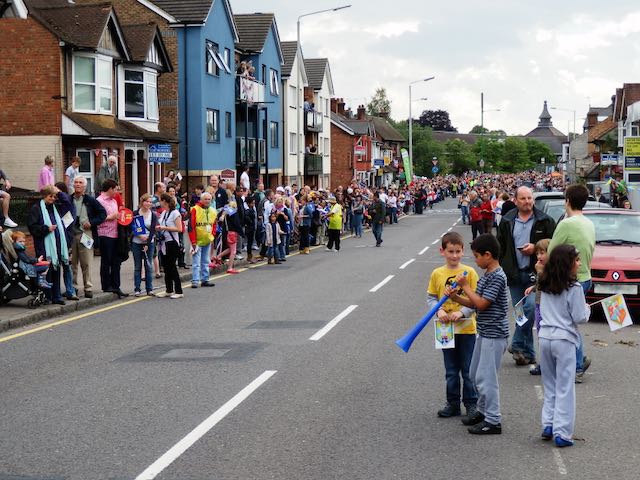
For the next 25 years the Rec was rather bland with just one set of children's swings near the Royal Road corner (chain locked on Sundays as was the custom in St Albans); and a public toilet block added in 1938, the same year in which emergency zig-zag trenches were excavated in preparation for war.  Gates in the fencing at bottom of Burnham Road gardens enabled quick access to the trenches.  Additional trenches were added in 1939 and 1940 for the benefit of the school; all were deepened to 8 feet, bricklined and covered, and fitted with electricity, heating and telephone.  They were accessed from steel doors at Royal Road with an emergency exit in the rec field, the latter can still be noticed in parched grass in hot dry summers.  A temporary day nursery arrived in 1942 for the benefit of mothers who worked in the munitions factories locally – this building is still in use as the Community Centre.  

A 1939 aerial of the recreation ground in the middle.  The 1938 open zig-zag trenches are visible.
So too is the diagonal footpath between the Hatfield Road and Royal Road gates. Within that
triangle is the new public toilets block and the children's swings.  Also clear is the grass wear from games of football!
COURTESY HERITAGE ENGLAND

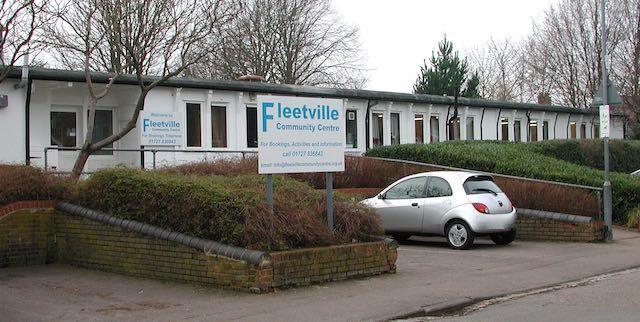
The temporary wartime children's nursery, today used by Fleetville Community Centre. The car is
parked where once a ramp and steel door led below ground level to emergency shelters for the
use of children at the school.

Two further installations during the war were an ARP hut next to the newly opened toilets, and an emergency water tank located where the zip wire is today.

Recent photo of the recreation ground without its original pre-war hedge line resulting from
road widening in the 1960s.

Plan prepared by Design Team Partnership in 1989 for a proposed underground car park for 194 cars under the recreation ground.  It would have occupied the southern end, but the proposal was not taken forward.

Post-war the junior children took to using the field for games lessons, but this was frowned on by the city council who wanted their bit field back from the County Council. A line of young trees were planted beside the shops, and in the 1960s a corner of the main road was shaved off and widened on safety grounds; resulting in the loss of the original field hedge with partial replacement of the original boundary wall.  Children living west of the rec will recollect an informal access point via a couple of missing railings next to Andrews' greengrocery.  That short cut disappeared with the improvements!

A scheme came to light in 1989 for a 200-car underground car park with ramp and six emergency staircases emerging at regular points in the field, as well as a number of light wells.  No one appeared to have considered the impact on organised events and team games.  Anyway, the plan was abandoned.

In more recent times there has been activity equipment for children and young people right across the park, and although the toilets were closed a popular cafe and seating area has appeared.

Next time we shall continue moving eastwards to the later developments between Royal Road and Tess Road (now Woodstock Road south). It might have become an entertainment hub!

Sunday, 26 April 2020

Middle of the Road

While most people are not leaving home to attend their work places, and the rest of us are venturing beyond the front door only to exercise or buy food, a new adventure, of sorts, has quickly grown, mainly out of necessity: walking in the road space.  Unless an oncoming pedestrian looks ahead and waits at a corner or pauses in an open driveway, we may be forced to take the lead and venture into the nearside road lane.  The opportunities are even there on normally busy roads, and the author has even spent the best part of an hour walking in the road and met no more than five or six cars.

Waiting for the Olympic Torch Relay in 2012; an excited throng along a quiet Hatfield Road.

Co-incidentally, in creating material for a local digital newsletter a month ago I made mention of an advance notice by the BBC that it intends to build a programme of London 2012 Olympic events, including running the full opening ceremony from the Olympic Park.  There is, of course, plenty of room in the schedules since the postponement of the Tokyo Olympics.  In the newsletter I reflected on one part of 2012 which most closely involved the East End of St Albans, which was the Torch Relay.  So we remember that joyous day along Hatfield Road, when, after the road closure and before the torch bearers passed westwards towards the city centre, a number of us walked casually in the middle of Hatfield Road, paused, chatted, even sat down, the latter just because we could!  I mused that such a chance would probably never again be experienced by any of us without putting ourselves in danger.  I wrote it at the time of the event, and I repeated it for the recent newsletter, but as soon as the words were on the page, the reality of a repeat opportunity was suddenly created, even for short bursts of time in Hatfield Road.

A busy Hatfield Road c1910, Fleetville, but not a motor vehicle in sight.

Probably the earliest surviving photograph of Hatfield Road, Fleetville has come to rare notice, partly because of the inferior quality of the image.  In spite of this it tells of a busy period of day outside the printing works, now replaced by Morrison's.  It can be dated to around 1910, as the County Council had carried out paving the length of Hatfield Road in that year.  But the numbers of residents or employees casually walking in the roadway, with no more danger than from passing cyclists, suggests the arrival of a motor vehicle was still a rare event.

The same view over 100 years later, with the print works building replaced by a supermarket.
COURTESY GOOGLE STREETVIEW


Being less confident than the 1910 photographer the author left it to a Google Streetview vehicle driver to capture a recent photograph taken roughly at the roundabout giving access to Royal Road in one direction and the Morrison's car park in the other.  This is where the 1910 photographer would have stood.  Royal Road would be just out of sight to the left of the picture and a gateway leading to spare land owned by Smith's printing works just to the right of the tree at the right edge.  This gateway would later be the entrance to Marconi Instruments Fleetville.  Behind the two hatted ladies closest to the photographer were trees and shrubs on spare land behind the lay-by in the modern picture, and a shop blind reveals the location of Bycullah Terrace.  The only other difference were the tall trunk telephone wire poles which marched their way along Hatfield Road on their way to Hatfield; today the wires are protected in trunking and lie beneath our feet.

It would not be long before the number of vehicles of all kinds grew in number along this road, sufficient to encourage and then force us to walk along the footpaths, but it would be another twenty years from the first photo before such a path was laid on the south side – there were no shops here.