Wednesday 12 July 2023

After 78 years


The Beaumonts estate as first laid out. Much of Beaumonts Wood has gone to provide ground for the schools and their playing fields. The broken orange lines never saw the light of day – a short stub of the extended Central Drive is now Oakwood School's entrance drive.


This map was surveyed in 1939.  The Central Drive/Oakwood Drive corner
is on the far right.  It would have been a cross-roads.  A swathe of wooded
ground has already been carved out to make the extension of Oakwood
Drive towards Sandpit Lane, which never happened. There are
other roads with no homes yet behind them. They would appear after WW2.

The final tranche of land belonging to Beaumonts Farm was offered for sale in 1929 and was acquired by holding company Watford Land. The company set out the road plan which would connect with Sandpit Lane, Beaumont Avenue and Hatfield Road, and at subsequent auctions plots were purchased by a number of mainly local house-building companies.  Two spine roads, Beechwood Avenue and Oakwood Drive, were to connect Hatfield Road with Sandpit Lane.  A third one had already existed, and had done so for centuries, Beaumont Avenue.  Beechwood Avenue had been aligned  with the agreement of the council, to connect with Marshalswick Lane as part of what was then known as the Circle Road (ring road).

Three connecting roads also appeared on the development map: Elm Drive, Central Drive and Chestnut Drive. None was completed to their finished lengths.  For the next ten years house building continued, working from Hatfield Road and the southern end of the estate, until in 1940 everything halted because of the war. Most of Beechwood and Elm had been completed. So too had the southern end of Woodland.  Hazelwood south was largely finished on one side and Oakwood had almost reached the future Central Drive.

Oakwood Drive looking towards the corner with Central Drive and in the direction of Sandpit Lane (not, of course, visible).  The (cream) house straight ahead would make such an extension impossible
today.

But restarting such a development after hostilities had finished would financially and logistically be a challenge; many pre-war housebuilding firms did not survive the interregnum, and the post-war license system limited how much building each could carry out.  In part the council came to the rescue by purchasing the swathe of ground from Woodland Drive to the school playing fields boundary.  A revised road layout was devised which took the boundary up to the playing field fence, which would then prevent Oakland Drive from continuing from the Central Drive junction as far as Sandpit Lane. Which later enabled number 51 Central Drive to be constructed in the space of the redundant road line.

The council then built a number of houses for rental in Woodland Drive and Hazelwood Drive north.

Of course, since our home area was effectively a huge building site children of the 1940s and 50s were able to take the short route from Oakwood Drive to Sandpit Lane by walking along the western side of the chain link fence erected by the County Education Department; and once the Hazelwood houses were in build it was easy enough to hop over the fence and follow the same line along the inside edge of the school field.  You could wonder how the author knows that odd fact if you like!  You could even wonder how much is known about the oak tree part way along that walked path close to where the Verulam School's pavilion is located.

Blue circle: Oakwood/Central corner. Red circle: approximate location of oak tree near Verulam School changing rooms. Yellow circle: beginning of path along Eagle Way. Green broken line: intended path
from Eagle Way to Central Drive. Green dotted lines: informal pathways worn by children in the 1950s.

Almost as soon as we had climbed over that fence we were able to nip across the field to Oaklands Wood, still there behind Oakwood School's site but now much depleted.  The woodland wasn't in any sense public; we knew that because there was a large sign fixed to a tree which informed us to KEEP OUT.  But we ventured there anyway.

I have reached this far in the post to reach the connection between the 1950s and a decision made recently...

Standing out against the sky at Oaklands Grange.

... in the 21st century and at the new housing on the edge of  land belonging to Oaklands, called Oaklands Grange.  Now that the homes are largely all out of the ground an increasing number of people have become familiar with Oaklands Grange and its access to Sandpit Lane not far from the opposite driveway from Newgates, a former mini farm, and the access drive from the Verulam School field.

To leave the Oaklands Grange development residents must walk first to Sandpit Lane – ah ha, so quite close to the old informal route youngsters walked in the 1940s and 50s; seventy-eight years or so after a certain number of those young children found their own way between Sandpit Lane and Central Drive.  If they weren't going to build the extension road, we'll find our own way.  So, an informal path was gradually worn in.   

The future path begins.

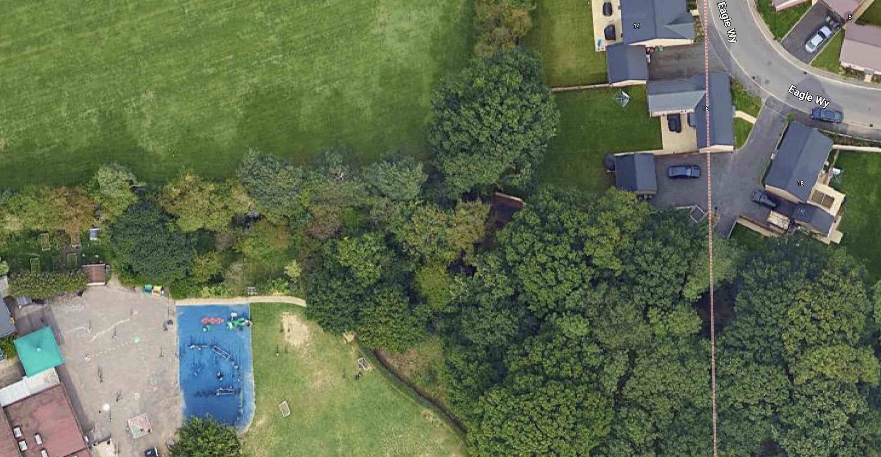
The path from Eagle Way skirts outside the boundary of Oakwood School towards
Central Drive.

Children living today at Oaklands Grange are to be given an alternative to the walk along Sandpit Lane, Beechwood Avenue and Central Drive to reach their schools.  They will be able to take a short cut.  The formal start of the path is already prepared at the southern end of Eagle Way.  Pass a few trees westwards and you will reach the former KEEP OUT sign and pass to the outside of the Oakwood School boundary, now itself wooded to reach the school entrance at Central Drive.

Two informal footpaths worn by 1950s children not trying very hard to keep out of trouble, now become part of the 2020s story of families finding their way between home and school along almost the same footpath.  There is little doubt that the child evacuees who came to be part of Beaumont Schools during the 1940s also adventured along these two routes to reach Sandpit Lane and to explore Oaklands Wood and its KEEP OUT sign.

We will look out for the official opening of the new link path, hopefully soon. 


Monday 3 July 2023

The Little Books 4

 Well, here we are at the fourth in our series of small format photo books about St Albans, and our pondering over how much they represent the Eastern districts within the full range of pictures  in the books.  We didn't start too well with two of the earlier publications, and in the third at least we encountered a section devoted to Clarence Park if not to Fleetville or Camp.


This week's little volume, is different in that it contains a specialist collection from the St A|lbans Museums archive, where you might expect to come across many of the best composed photographic studies.  Around St Albans (ISBN0752422898) compiled by Anne Wheeler and Tony Stevens is from the series Images of England by Tempus Publishing.  Around St Albans is definitely in print, which according to the Waterstones website is priced at £12.99.  For comparison with the Abebooks website, which has been necessary for the previous little books in this blog series, there are currently 8 copies available, ranging from £3.39 to £24.18.

Around St Albans contains the largest number – 200 photos – of all the little books covered so far, and as with the previous volume, has divided the contents into fourteen small subject related sections.  The earlier two books, you will recall, were limited to mixed subject matter. In this week's little volume although Clarence Park is not included, the district of Fleetville is specific in this book but it does not include the other major eastern settlements of Camp or Marshalswick.  It is also contains a relatively small number of pictures (11), although the occasional photo appears within other subject sections. So there are occasional surprises through the book.

The first aerial is in Fleetville.  The long building lines centre right are the original printing works, 
with later additions for the hosiery mill behind. The taller block was post WW2, later taken
over by Marconi Instruments.  The surrounding houses and trades are greyed down.
COURTESY ST ALBANS MUSEUMS

The second aerial is close by the one above.  The two roads are Sutton Road (foreground), and
Hedley Road (right).  This is the early incarnation of Nicholson's coat factory. The branch railway is on the left and the first informal recreation space meets the tree line and Sutton Road.
COURTESY ST ALBANS MUSEUMS

A cottage at Colney Heath, occupied by the Bush family c1900.
COURTESY ST ALBANS MUSEUMS

There is also a much improved representation of the villages and other rural spaces than in any of the earlier books: three each from Colney Heath and Wheathampstead, one from Smallford and 3 from London Colney.  However, agricultural scenes are still exclusively from farms near St Michaels. Under Industry there are several images of Ballito, one of Marconi Instruments and one of the Co-op Dairy.  Railways feature three images, all from the bridges along London Road.  One Camp shop shows Tucketts (later to become Dearman's).

The New Camp Stores run by the Tuckett family, who also traded from near Sandfield Road,
Fleetville.  The above shop was on the corner of Camp Road and College Road. Later it would
be taken over by John Dearman. The premises is no longer retail.
COURTESY ST ALBANS MUSEUMS

The other Camp district photograph features the c1914 composed picture of soldiers, probably in training, outside Camp Elementary School.  The County Boys' School's (named Verulam School in the book although it would be another 20 years for that name to appear) new 1938 craft workshop classroom is featured, as is an outdoor shot of an early post-war athletic event.  We find an unusual triple picture of an Adult School group, although it is just before the Stanhope Road premises was opened and would have been at or near its Lattimore Road base.

In a lovely low-key touch a wedding is shown: an unnamed couple outside St Paul's Church, posing on the Hatfield Road footpath close to the current bus stop and showing the Co-operative grocery shop fascia in the background.

The third aerial in this set was taken in 1959 above Marshalswick, where the new estate was
under development.
COURTESY ST ALBANS MUSEUMS

The final days of Sander's office buildings in Camp Road are more visible in one picture as the old railway bridge has been removed leaving a remarkably open streetscape. Finally, in the section titled The Rural City is an aerial shot from 1959 of the growing new Marshalswick estate.

Leaving the picking out of East End scenes for a moment, one feature of this little book which makes it stand out is the opportunity taken to select images from collections.  This is possible because of the rich and diverse St Albans Museums archive. Alf Gentle and Arthur Melbourne Cooper, both accomplished craftsmen in their own right, each have their own chapters, as does the former National Children's Home.  In particular Cooper's little collection is a rare survivor.

The study of two young girls shows them plaiting, an early process in the making of straw
hats.  They may have been at home, or at an industrial school.
COURTESY ST ALBANS MUSEUMS

One of the stand-out photographs in the collection, which probably should have been in a Schools section but ends up as part of Industry, is the child study of two young children occupied casually in plaiting, a trade occupying the time of hundreds of grown ups and children in the late 19th and early 20th century.  And although the location is not specified it is just possible these two girls were residents of one of the eastern hamlets or isolated cottages.

While it is difficult to be specific about a few of the East End subjects or locations a more respectable 38 photographs appear in this overall collection of 200 images, with the quality of the subject work and reproduction also the best of the bunch so far.


Above photographs courtesy St Albans Museums.

Copies of this book available from St Albans Museum+Gallery at the Town Hall.