Saturday 25 June 2022

Smallford Cross Roads in 1946

 When the RAF flew overhead in the autumn of 1946, shooting their streams of images of the ground below them, the name for this place, Horseshoes, had only recently begun to lose its name in favour of Smallford.  Historically a separate hamlet of the name, Smallford, existed at the lower end of Colney Heath Lane where was Smallford Farm and, appropriately, a ford (now culverted) across the roadway.  Smallford was also the name of the parish in which it was situated. In contrast to the reducing number of homes in and around the lower road, a growing collection of buildings north of Smallford Station and around the crossroads already had several times more dwellings than than had ever existed near the Farm.  So the name was appropriated and moved uphill.

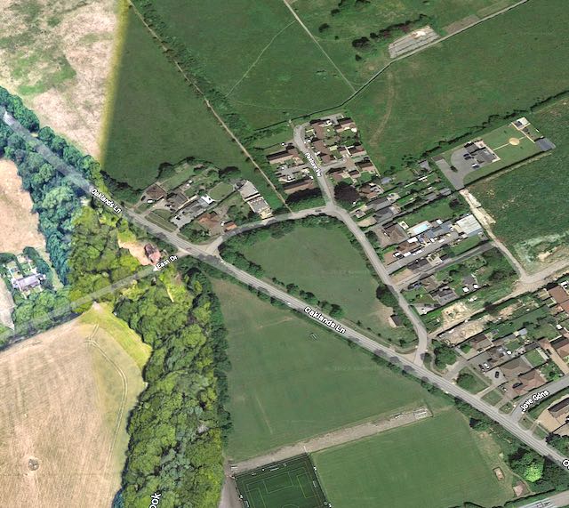
This 1946 aerial photograph shows the area around Smallford crossroads (now roundabout).
Hatfield Road crosses the picture left-right, and Oaklands Lane and Station Road from top left
to bottom right, though in 1946 Oaklands Lane was called Sandpit Lane.
COURTESY HISTORIC ENGLAND


We have an improved contrast on this film compared with last week; but still tough work for the camera in the late afternoon sun.  The use of the term Smallford Crossroads was appropriate in 1946; it would be some years before a roundabout would be installed in answer to the increasing accident toll.  An endless number of right turn manoeuvres from any of the crossroads' four arms having main road priorities in place, gave the location's name a reputation throughout the city.
Ahead is Hatfield Road towards Hatfield, Station Road to the right and Oaklands Lane to the
left.  On the left corner is the former turnpike toll house in a photo taken in 1935, but believed
not to have been demolished until after 1946.  The cottages on the right have now been
replaced.  The Three Horseshoes is further along on the right, and the Four Horseshoes
Beerhouse on the left close to the Sear & Carter Nursery drive, now the entrance to
Notcutts Garden Centre.
COURTESY THE HERTS ADVERTISER

The proposal to create a safer junction more than ten years previously included the demolition of the turnpike toll house on the north-east corner and the adjacent old cottages. The result was a modest widening of Hatfield Road.  It is uncertain whether the toll house had been occupied after the transfer of the main road to the Highways Board, but one way or another the building survived until a Herts Advertiser photographer captured the Smallford scene in 1935.  The widening may have been planned in the mid thirties, but the 1946 aerial photo still indicated its presence.

Early 20th century view of the Three Horseshoes, petrol station and former cafe, and now demolished cottages.  Intros view looking towards the crossroads and St Albans the former tollhouse and cottages
are on the right.

The Three Horseshoes public house and restaurant now run by the Vintage Inns Group, with
the former blacksmith's premises attached to the left.


The name of the main road through the hamlet sometimes confuses; but it remains Hatfield Road – we're up to the 600s in house numbering – until Wilkins Green Lane and Popefield Farm, at which point it becomes St Albans Road West, probably resulting from historically earlier boundaries.  The aerial photo reveals the location of the Three Horseshoes public house, now also a restaurant.  The view also shows its adjoining blacksmith neighbour, now also absorbed into the restaurant premises.  Both would have been key businesses in turnpike days.  The cottages to the east of the Three Horseshoes still owned their own individual rear gardens, although the 1937 Ordnance Survey map does not identify their separate curtilages, two generations before their land was subsumed into the public house for parking and special events.  Meanwhile, the dwellings behind the wall close to the crossroads on the south side, visible in the Herts Advertiser picture have now been replaced.

No-one could ignore the largest features  in the landscape, the extensive glasshouse rectangles.  These began to arrive in the early years of the twentieth century when their owners were priced out of the Lower Lea Valley by the demand for housing and the need for  industrial space.  Market gardening began to move northwards in response to lower agricultural land prices where farming activity had become depressed.  Although many glasshouse smallholdings have closed down, the 1946 photograph identifies the location of four of them.


A pre-war aerial photo of J Nielsen's market garden glasshouses. Today virtually the entire
field is under glass and the present Glinwell firm has also moved into the next field to the right with the
stream, Smallford Brook, in it.

On the south-west corner is the largest market gardening site which began here and has significantly expanded, was Jacob Nielsen.  Today, with even greater expansion to fill the original field and into the former Ballito Sportsground, the business is now Glinwell Salads; it has Boggy Mead Spring/Smallford Brook flowing through it.  The company has recently opened a farm shop, repeating an earlier enterprise where Nielson's had built a strong local visitor base in the 1960s.

North of Glinwell was the Wellfield Nurseries on an extensive acreage which, in the 1970s, was cleared to make space for playing fields used by Sandfield School and are now part of St Albans Rugby Club grounds.  To the east of Oaklands Lane, until recently was Chester Nurseries which has now succumbed to the seemingly endless quest for new housing. 

The former Sear & Carter Nursery is now Notcutt's Garden Centre.

The final business is the one all locals know as Notcutts Garden Centre.  Previously it had been the nurseries of Sear & Carter from the 1930s.  While the firm had its small nursery and shop in Fleetville next to St Paul's Church, it had rented nearby unused plots for growing on shrubs, and then opened a much larger nursery and trial ground at Smallford.  You would have left the main road along a drive towards a bungalow at the heart of the operation.  The same drive is used to enter the garden centre site today.


There's a lot going on here: the former double bend in Oaklands Lane, Wellfield Nurseries (lower left)
and Chester Nurseries (right), and the former Radio Listening Station in the middle of the
field right at the top.  A curved access drive gave access to the building.
COURTESY HISTORIC ENGLAND


Drive instead northwards along Oaklands Lane – which in 1946 was still called Sandpit Lane – was what the Highway Code might label a Z bend; sharp left and then sharp right.  Since the county council had acquired the Wellfield Nursery land the opportunity was taken to remove the double bend.  Today we know where it was because opposite East Drive (at the old East Lodge of Oaklands Institute) is an unnamed road which returns to Oaklands Lane further south at the bus stop.  The section of Oaklands Lane between these two points is the straightened section of road cutting across a corner of the former Wellfield Nursery field (the little stub of the field remains in the loop).

A straightened Oaklands Lane.  The Lane used to follow what are now two sides of the triangle.
The grassed triangle was part of the northern corner of Wellfield Nurseries field.  The concrete
base of the former Radio Listening Station is still visible with the parch mark of its curved
drive leading to Pasture View on the small Radio Estate.
COURTESY GOOGLE EARTH

Along this old loop are two recent access roads leading to new housing..  Pasture View leads to a small estate at the former field of the Radio Listening Station; the second an even more recent estate which replaces the above mentioned Chester Nurseries.  There is another more established estate called Jove Gardens created from a further small smallholdings of glasshouses.  Between here and the paddock behind the former Turnpike Toll house you can see a dark grey field on the aerial photo which was developed post-war with wide semi-detached homes accessed from a service road.

The Radio Listening Station with its curved access drive.  The family was probably out for a Sunday
afternoon walk.
COURTESY ALISON MANN

The above mentioned Radio Listening Station was in the middle of a field to the north of the Radio Estate (Pasture View).  Now demolished, the remaining concrete base can still be seen.  The station was built in the late 1920s by the General Post Office (GPO) and was part of an extensive network of similar listening posts throughout the UK, particularly crucial before and during the Second World War.

There is more to the little hamlet around the crossroads than we might imagine.

Sunday 19 June 2022

Queen's Court in 1946

 One small part of Fleetville which I sought on the RAF's 1946 flyover photo survey is the area on the north side of Hatfield where today is located Queen's Court, the three-block three storey flats developed for St Albans City Council.  However, Queen's Court did not emerge from the ground until 1952 and formally opened in Coronation Year 1953.

Unfortunately, peering at the image (below) there is little clear detail, and we need to rely on a supplementary details in describing the story in order to make sense of the camera view.  To be honest, the 1946 experience of walking along Hatfield Road was a mess.  It was not a location where photographs appear to have been taken – these were the days of film and the additional costs of processing, and as with most other aspects of life our resources were frugally managed.  If photographs were taken they seem not to have survived or circulated, unless our readers know differently.

An extract from the RAF aerial survey in October 1946. The north-south roads on the right are
Beechwood Avenue and Ashley Road.  A triangular shape in the centre is the focus for our
exploration in this blog.
COURTESY HISTORIC ENGLAND


The triangle is between the Alleyway, a footpath from Beaumont Avenue towards Woodstock
Road South, and Hatfield Road.
COURTESY GOOGLE EARTH

In this account we will focus on the orange boundaries on the following map.  To the east is a group of five villas built at the start of the twentieth century.  These finish where the footpath, or alleyway as it was popularly called at the time, meets Beaumont Avenue.  The western boundary where the Thrifty Cars site is, but in 1946 it was Currell's Garage as it was about to be nationalised under the name British Road Services (BRS).  Also absorbed into the present site was a bungalow to its right.

The five villas between Beaumont Avenue and Queen's Court.

In addition to the five villas mentioned above there were two other detached, both on wide ploys which extended back to the alleyway. Their short lifespan was the result of a development battleground between commercial Fleetville and residential building which would have contrasted with the tightly arranged terraces between The Crown and Arthur Road.  The City Council, which in the 1930s received increased responsibilities under the formative Town & Country Planning Act, came to the conclusion there were already enough shops along Hatfield Road, and that as traffic along the main road was already busy, houses fronting Hatfield Road would be better than short side roads leading to blocks of flats which were becoming fashionable at the time.

A photo taken in the 1930s.  On the far side of Hatfield Road was Currell's Garage and a bungalow
beyond.  This is now Thrifty Cars.
COURTESY STALEY HAINES COLLECTION


Photo from c1910 from the junction with Ashley Road and looking westwards towards
Fleetville.  These are the villas on the north side of Hatfield.  The most distant house was
said to be the first to be demolished in the late 1930s and part of the site occupied by the wartime
National Fire Service, and later by Queen's Court flats.  However the aerial photo shows both
homes to still be standing, though undoubtedly, empty in 1946.
COURTESY HERTFORDSHIRE ARCHIVES & LOCAL STUDIES


It was the adventurous owner of one of the spacious villas who first proposed building flats on a spare plot to the side and behind his home, with shops replacing his frontage.  When the plan was turned down by the Council, the applicant went even further, purchasing the house of his neighbour, began demolishing both and extended his initial plan.  Shops would be built along the main road in front of both villas, with a side road leading to blocks of flats behind – a rather provocative proposal one would have thought?  Or perhaps the reporting was rather confusing.  So determined was he, according to the press, that he pushed ahead shortly before the outbreak of war in 1939.  In fact, the aerial photograph shows the structures apparently still standing in 1946, though empty.  The gardens and a tennis court were left neglected.


A new fire tender purchased by St Albans City Fire Service shortly before becoming part of
the expanded fleet of the National Fire Service.
COURTESY THE HERTS ADVERTISER

As local and national bodies were set up for wartime emergencies and a range of defences on the home front, the newly-formed National Fire Service (NFS) seized on the opportunity to grab the site, which included an unsold plot where the branch library would later be built.  The NFS rather strangely numbered what was left of the two villas NFS1 and NFS2. For what purpose is unclear. It also built a training and operational building on the west side of the site.  It is presumed the former gardens were utilised for the parking of its fire tenders and other vehicles.

Soon after the end of the war the vehicles had gone and the windows of the operational building had been shattered by vandalism, entered and probably occupied by tramps and other homeless individuals.  Children made use of the open space as an unofficial adventure playground and broke through the fencing on the alleyway boundary.

One of the three blocks forming Queen's Court

In 1950 the City Council acquired the site and, although no shops appeared, it seems to have had a change of mind about flats, with not one, but two, access roads!  The result was Queen's Court, winning an architectural award in the process, which included the grassed square and brick frontage wall, name sign pillars and lines of lavender shrubs.

Closure and demolition of the branch library.

The small block of flats which was built on the site of the former library.

The Council's Library Committee had been searching for a suitable site for a Fleetville branch library.  Criticised for being remote from the heart of Fleetville as it then was, nevertheless it was still a branch library.  The pleas for access to a library had begun even before the Carnegie Library (Victoria Street) was opened in 1911, but at that time districts such as Camp and Fleetville were beyond the City boundary and their residents were denied the use of the central  facilities.  But from 1913 onwards the East Ward councillors, including William Bond and Stephen Simmons frequently campaigned for the young districts to have the benefit of their own branch library.  It took more than forty years to achieve, being opened in 1959, and its life was barely as long as as the period waiting for it to happen.

The new branch library replaced the existing mobile library van.

Taking another look at that section of the aerial photograph you would struggle to identify anything which might tell the story above, but at least today there is a fine estate of flats, and a smaller building of accessible flats where the branch library arrived – and departed.


Sunday 12 June 2022

The Rec in 1946

 Just when you think you know a place well, along comes a fresh element about which you had no previous knowledge.  Or almost no knowledge; but more of that shortly.

The map below covers the same area as this 1946 aerial photograph taken by the RAF.  
Hatfield Road crosses the bottom of the picture. Fleetville Recreation Ground (Fleetville
Park is left centre with Fleetville School to its right.  In the top section roughly west to east is
Burnham Road and lower Brampton Road.
COURTESY HISTORIC ENGLAND

In the previous post you will be aware of a series of RAF aerial photographs taken in 1946 and now available to view on the Historic England website.  In that post we explored The Park.  This week I've chosen to home in on part of the very heart of Fleetville: the Recreation Ground, Fleetville Infants School, and Royal, Woodstock, Burnham and Hatfield roads.  The aim is to contrast today's  topography with that of 1946.  In so doing we have to manage an image of high contrast created by the bright sunshine and deep long shadows on the day of the flyover.

The map covers the same area as the aerial photo.
COURTESY OPEN STREET MAP CONTRIBUTORS


The very recognisable range of pitched roofs of Fleetville School, which were two distinct buildings in 1946, with a playground space between the junior and infant departments, is now, one joined structure and also enlarged at the northern end (the old Boys entrance of elementary school days).  The wooden Hut, consisting of two classrooms, arrived in 1938 is now replaced by a large modern hall on the Woodstock Road South side, and the long narrow structure further north along the same boundary were the outside toilets.  Although these have now gone the high boundary wall still exists as a kicking wall.  The space south of the former Hut consisted of a garden for the adjacent police station and house (shown as car park P on the map) just behind the Post Office.

Fleetville School (Infant School today) with the wall on the right.  Behind this was once the outside toilets.

Turning our attention to the Recreation Ground (Fleetville Park on the map), a temporary building had been constructed just behind Royal Road in 1942.  It was a day nursery for the young children of employees at the munitions works in Hatfield Road (Fleetville Community Centre and Morrisons on the map). The bright fresh concrete slab on which the building was placed shone out in 1946. Just visible on the Royal Road side of the building was where the embankment down to road level had been partly cut away with a concrete ramp leading down to underground tunnel shelters; the building had been placed on top of the tunnels cut in 1938 and 1939. The ramps have now been levelled to create the present car park in front of the community centre.

The rear elevation of the Community Centre


Wartime street shelters constructed in the roadway.  This example is from Manchester.
COURTESY MANCHESTER LIBRARIES


This leads us to a recollection given to me a few years ago; a resident recalled when he was a child that "a few" street shelters were constructed in the roadway of Royal Road.  I searched in vain for confirmation but found none – until now, for the RAF photo taken in October 1946 clearly shows six structures on the footpath and half of the roadway outside the nursery building.  They must have been demolished and removed in 1948 for I do not remember them.

Residents wishing to see the (temporary) community centre building will need to be quick; it is expected the building will be demolished in July of this year, in preparation for a new building to go up in its place.

An emergency water tank similar to, but much smaller than the one, on Fleetville Recreation
Ground.  This example is from Aston, Birmingham.
COURTESY BIRMINGHAM CITY ARCHIVES

The rectangular structure near the Hatfield Road boundary was an emergency water storage tank for the National Fire Service, clearly emptied for safety, next to which was the ARP hut.  Here is this week's question: halfway along the diagonal footpath between Hatfield Road and Royal Road is a circular shape.  Although I can identify the children's swings to the right of it, was there a revolving ride, such as a roundabout or witches' hat?  I remember neither of those, only the swings.  Anyone with further information please contact. 

On the south side of Hatfield Road, far from straight, near the southern edge of the photo are the long parallel roofs of the former Fleet Works, the Smith's Printing factory, by 1946 being used as Ballito hosiery mill.  Immediately to its left is a narrow grey-looking site with seasoning sheds to the left, which today is part of the surface parking for Morrison's.  But in 1946 was a busy timber yard owned by the Lavers family.  Recognisable by its shape is the outline of the former Central School, now Fleetville Junior School, today little altered from its original form.

The timber yard of W H Lavers, Hatfield Road, now under the car park of Wm Morrison's 
supermarket.  The site was a busy one both for building companies, general contractors and
homeowners.
COURTESY ST ALBANS MUSEUMS


The north-south road to the west of the Recreation Ground is Harlesden Road, one of the many
parallel roads which helped to swell the population of Fleetville from the early 20th
century.  This is Harlesden Road, from the Hatfield Road end, taken around 1914.
COURTESY ST ALBANS MUSEUMS


Many photos of Bycullah Terrace are taken from the western end.  So, just for a change
here is a picture taken from the Sutton Road corner about ten years ago.

Back on the north side of Hatfield Road is the eastern end of the Slade building estate of the early 20th century; the compact terraces and semis of Harlesden, Burnham, Brampton and Woodstock roads, and the two long terraces of Arthur Road.  It is disappointing the deep shadows cast by the Ballito factory hide all of the detail of the most interesting section of Hatfield Road at Bycullah Terrace – Fleetville Shops. 

If you live, or your family lived, anywhere on this photo you will pick it out immediately.  Fleetville was, and still is, a busy suburb of the city.  Until the previous year, 1945, it still hummed with the young voices of children who had become honorary guests of St Albans, having been evacuated here from London boroughs and the Sussex coast.  Let's remind ourselves: this was seventy four years ago.

Monday 6 June 2022

The Park in 1946

 The question which follows is not Which park? for this is the road named The Park, looping off the northern side of Faircross Way.  The roads between Sandpit Lane and Marshalswick Lane had previously been the historic estate and gardens of the Marten family's Marshals Wick House, sometimes referred to as Wick House.  The house was torn down in the 1920s.  But a recognisable portion of the gardens came to be regenerated as The Park, a horseshoe-shaped road which today contains 72 mainly large detached homes and mainly built in  the 1950s and 1960s.

Faircross Way is the only west-to-east road; the middle road, Harptree Way, was cut back to the 
stump we see today; the northern parallel road was lost altogether to create the horseshoe road 
named The Park.
COURTESY ST ALBANS MUSEUMS

The Park and Faircross Way shown in 1946 on an RAF Aerial Survey.
COURTESY HISTORIC ENGLAND

The germ for this post, and a few still to come, emerged from the appearance online of a number of aerial photographs taken from RAF reconnaissance aeroplanes, whose pilots where employed following the end of the second war in undertaking aerial surveys.  We can gather from the surviving negatives that the survey, if there had been a complete coverage of the district, is now only partial, resulting in a single west-to-east flyover, which fortunately provided a wide vertical series of views of the northern half of St Albans, capturing, for example Fleetville but not Camp, Oaklands but not Hill End and so on. One road which stands out because of its shape and the newness of its concrete road surface at the time is The Park.  The initial intended road layout from the early 1930s was very different,  a series of three parallel streets running from west to east, but a revision dated 1937 introduced us to a more unusual horseshoe form  named The Park.   

The western divided exits between The Park and Faircross Way.

Meanwhile, St Albans Council had been wrestling with future arrangements for facilities such as publicly provided recreation and sport in a city recently having a considerably larger population.  A number of sites overall had been identified, but cricket remained difficult to locate for supporting the more formal facility at Clarence Park.  The council had its eyes on two possibilities, both in the Marshals Wick development since no housing had begun before the end of the war. One would be an extension of The Wick in Marshals Drive; the other was the land inside The Park.  It is likely neither was proceeded with given the high cost of purchasing the land.  The sole agent and developer, Mandley & Sparrow, would also  undoubtedly have raised objections about the effect of future house values at The Park, and perhaps the risk of cricket balls hurtling through front windows!

So let's check how The Park looked in 1946 and compare it with today's streetscape.  Many of the Marshals Drive plots had been sold in the 1930s and a few homes had been built.  Owners who had been forced to wait until licenses were available after 1946 discovered materials were in short supply, only sufficient for small homes considering the wide sites they were to sit on.  There were around twenty occupants in  Charmouth Road east and a nominal number in Homewood Road near its Marshals Drive junction.  Plot owners in those locations would also have to wait for more generous licenses.


Space or no space; both are on show at both ends of Faircross Way.

Fair Cross Way was a divided word when first placed on the map  (and street plates at both ends of the road still offer both alternatives).  By 1946 a round dozen homes had been occupied on the south side, although several consecutive plots opposite The Park had been held back for later development.  Perhaps views directly along the horseshoe might command higher prices.

What was left of the former grounds of Marshals Wick House was a wide swathe of open parkland between Charmouth and Homewood roads.  A boundary line of trees extended NNE from Sandpit Lane towards Charmouth Road and onwards to Sandridge Road at the railway bridge.  A small number of mature trees were growing within the horseshoe roadway, many of which survive in the present private gardens.  I am surprised not to discover on the aerial image, an extensive collection of temporary allotment gardens, commonly found in other parts of St Albans.  But there is evidence of, perhaps, grain or grass recently cut for hay (the photo was taken in October).  Lines of small shed-like buildings occupied land immediately north of The Park.  Perhaps these had supported earlier allotments or smallholdings.  We should realise, of course, that Marshals Wick House and its estate was first offered for auction as early as 1921, the sale process taking many years to complete, during which time it is likely the grounds were not fully maintained.

For couples and families living within "local adventure" distance of The Park traditional Sunday walks were popular in the 1940s and 50s.  The open spaces were unofficial playgrounds for children, picnic spots for those unable to afford travel to more distant or real countryside, and perhaps wistful journeys for future homeowners.  However, this landscape did not remain static for very long, as the street directories reveal.

The Park from a recent aerial photo.
COURTESY GOOGLE EARTH

If you were going to purchase a plot in an otherwise empty The Park which side of the road would you choose, inner or outer?  With the likelihood of benefiting from a borrowed front landscape within the horseshoe perhaps you would have selected a plot on the outer side.  And that's just what the first three purchasers did: Alfred Gentle (previously from Church Crescent), William Bird (formerly at St John's Lodge, Beaumont Avenue) and John Miskin (moved from Temperance Street).  They all built their houses in the early fifties, at the northern end of the horseshoe and within touching distance of the rear gardens of Marshals Drive nearest to the old house.  It is entirely possible they had purchased the plots before the war began in 1939. The next three occupiers, English, Preece and Wynn, also purchased plots in the same confined block on the outer northern sector.  For a short period these six had the road to themselves, after which a veritable estate of bespoke homes came under construction between 1958 and 1960, by which time only eight vacant plots remained.

But that was only half of the account: at the same time all but three of the inner plots were in build, and the owners' list for The Park and Faircross Way contained a fair sprinkling of the city's trading success stories and professional businesses. 

The Park, a streetscape.

There remains, however, one query with the 1946 RAF aerial photo.  Although the level of detail is not high there are two plots which already appear to have houses on them; one at the middle of the north-west curve (seems to have a circular feature in the front garden) and one as that same curve becomes straight again.  This suggests that two homes were completed earlier than surviving directories suggest.  Maybe they were begun earlier but could not be completed before the 1940 moratorium.  Anyone who has an answer to this query is sure to post an answer!

The original split entry and exit junctions of The Park have remained in tact; many former estate trees have thrived and been much enriched by house owners planting their own; the street tree programme; the original silver street lamp posts in place (though they have lost their elegance since the LED conversion in recent years); and the driving schools of the district who warmed to the quiet, lack of street parking, the junctions and curves, all regularly incorporated into their training routes.

There is no doubt a stroll or cycle ride in this vicinity will prove to anyone the streetscape has kerb appeal in spades.