Showing posts with label Three Horseshoes. Show all posts

Sunday, 26 March 2023

Smallford Settlement

 This week the tithe map extract shows the area we now know as Smallford.  Before the 1940s the group of buildings east of the present roundabout, and previously called Smallford Crossroads, was known as Horseshoes, after the name of the public house along  Hatfield Road.  Early maps also referred to the settlement as the Four Wents – four winds; there are similar references to wents in other parts of the country including in the East Sussex South Downs National Park.

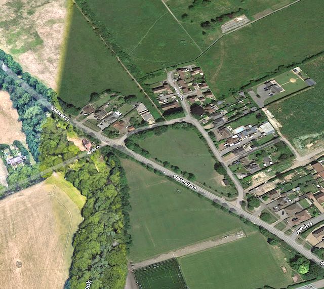
Smallford hamlet and its surrounding fields.
COURTESY GOOGLE EARTH

The first map below also charts fields surrounding Smallford, and their names provide one or two clues about usage and topography.  A reminder again that the orientation of the tithe map has been rotated through 90 degrees to conform to modern maps – which it doesn't quite achieve but is near enough.

Extract from the 1840 tithe map.  Roads clockwise from the top: Sandpit Lane (now 
Oaklands Lane); Hatfield Road east towards St Albans Road West; Sleapshyde 
Lane (now Station Road); Hatfield Road towards St Albans.
COURTESY HALS

We'll begin with the water course marked in blue and the narrow fields through which the stream still flows southwards. One was named Drunken Bridge Meadow (693) and the other Boggy Mead Wood (259).  The stream continues as Smallford Brook until it reaches the River Colne.

Water is also referenced in field 268 which the tithe map names Well Field. There is a little conjecture here, but by the road  – then known as Sandpit Lane but now renamed Oaklands Lane – in this field was a small plot which can just be identified as 269 with a cottage and garden (all dwellings were then named cottages).  Today it is at the beginning of a 1960s road straightening, close to the bus stop. A rugby club now has its entrance drive. During the 19th century it housed the St Peter's Pest House – containing anyone with a contagious disease – and was only closed and demolished after the opening of the Sisters Hospital on the St Albans City Hospital site. Well Field later gave its name to the large nurseries which occupied this field until the 1940s, when it became a sports field for the County Council.

Fields are so named for various reasons.  Field 270, an L-shaped fenced area for grazing, had the name Toll Gate Field because the turnpike gate was at the cross roads.  On the other hand the twin fields south of Horseshoes hamlet (578 and 579) were named Great Shepherds and Little Shepherds, which probably referenced sheep grazing, though the St Peter's Tithe Award Book indicates both fields to be arable at that time.  Field 275, now largely occupied by Notcutts Garden Centre and the mid 20th century homes along Oaklands Lane, was named, for obvious location reasons, Horseshoe Field. And if you couldn't think of a better name for your field, why not tell everyone how large or small it is.  Hence, field 276, where used to be the Chester nursery and today is also the Radio estate, was identified as Fourteen Acre field, which was, unsurprisingly, 14 acres in area.

Closer view of Smallford hamlet, orientation as extract above.
COURTESY HALS


Current and building use map of Smallford.
COURTESY OPEN STREET MAP CONTRIBUTORS


Turning our attention to the plots along Hatfield Road which comprise Horseshoes itself, we might be surprised that no expansion has taken place since the 1840 tithe map (though, of course, modern housing has spread along Oaklands Lane and Station Road, the latter named Sleapsyde Lane before the arrival of the railway; west of the crossroads of course St Albans has joined hands with the hamlet!)

On the north side of Hatfield Road, always the least built on, were three buildings.  Two of them (in 273) wrapping round the crossroads north-east corner both belonged to the Trustees of the Turnpike Road.  The Trustees also owned a little plot of the north-west corner, now in front of Cayton's veterinary practice and Busy Bees children's nursery.

View eastwards from the crossroads (Smallford Roundabout). Former turnpike house on the
left.  Four Horseshoes further building on the left; Three Horseshoes furthest visible building
on the right.
COURTESY SMALLFORD & ALBAN WAY HERITAGE SOCIETY


View westwards with Three Horseshoes on the left and Four Horseshoes distant right. 
Painting by John Buckingham, c 1860.
COURTESY ST ALBANS MUSEUMS

At the eastern end of the north side of Hatfield Road was a building standing on its own with a shelter on its left (in this painting by John Buckingham it near the right edge), with the first iteration of the extant cottages on the left. The Four Horseshoes beer house, which survived into the post world-war two era is further along the road – probably the red building.  For anyone exploring the strip of land on which these properties stand, from round the corner in Oaklands Lane to the footpath east of the garden centre and on the north side  might wish to investigate the plot descriptions Upward Lane at the crossroads, and Heggs Garden Spring and Eggs Garden Field, both forming a roadside strip the full length of the main road.

Thomas Kinder owned the Three Horseshoes building and the adjacent blacksmith's forge (375), which were then separate structures but now form the unified Vintage Inns restaurant. To its east are the cottages which were also shown on the tithe map.  They consist of a terrace of four cottages, as today identified by four chimney stacks.  They each had their own rear gardens although these have now been subsumed into the Three Horseshoes parking and outdoor dining zone.

Cottages, Three Horseshoes and Filling station on south side of Hatfield Road.

West of the public house was a long narrow plot of, probably three cottages and their roadside gardens (576), part of which became a cafe and small petrol station. In more recent times the cottages were demolished and the fuelling station significantly enlarged.  The final cottages were in a wrap-around garden plot (577) and as with the others, standing parallel to Hatfield Road at the crossroads.  These cottages have since been replaced by an attached pair of houses and a corner bungalow.

Three Horseshoes, cafe, early filling station and now demolished cottages beyond.
COURTESY SMALLFORD & ALBAN WAY HERITAGE SOCIETY
It will be useful to return to this hamlet occasionally to investigate other elements of the extended settlement, including the former railway naturally.


Monday, 24 October 2022

Absent Photo: Smallford Tollhouse

 You might be surprised to note the location of this week's absent picture, convinced you have viewed a photo of this building on this very blog and on the SAOEE website itself.  You would, of course be correct – and to prove it here it is below.  Undoubtedly one key reason for its survival was the building's survival, thought to have been the early 1950s, which gave it a better chance of being photographed. In fact by the Herts Advertiser in 1935 when the demolition proposal, for road widening, was first announced; but the war intervened.


A press photo taken in 1935 when it was anticipated the cross roads junction would be widened
with the consequential demolition of the toll house (left), which we eventually lost in the early
post-war period.  Hatfield Road facing east towards Hatfield. Station Road on the right and, 
mainly hidden Sandpit Lane (now renamed Oaklands Lane) on the left.
COURTESY HERTS ADVERTISER

Many readers will already be aware that the HA, several years ago, destroyed its entire photographic library in order to save space.  So the version shown here is a low grade photographic copy taken directly from a paper copy of the HA at Hertford.  The result is therefore unique.  I say unique, unless other good images taken, perhaps, post war come to light.

OS map published 1898 after the closure of the turnpike, but the toll building remains, circled in
red.  The house faces both St Albans and Station Road.  This is the first edition of the map
which identifies a telephone call box (TCB) at the Three Horseshoes PH.
COURTESY NATIONAL LIBRARY OF SCOTLAND


Let's therefore investigate what our image shows, and therefore work out what it does not reveal.  The context was an event, as mentioned above, about to take place in which the highways department of Hertfordshire County Council was to widen a section of Hatfield Road at what was then known as Smallford Crossroads.  The photographer captured the scene which would shortly change.  The road shown is Hatfield Road facing eastwards a short distance before its name changes to St Albans Road West. On the right is the entry to Station Road, but the fourth road, which we now know as Oaklands Lane and which then was still called Sandpit Lane, is almost completely hidden from view.  Its entrance is just visible in front of the corner building.

It is the corner building which was the toll house, a much more substantial building than others in the locality, such as the Hut Toll in Colney Heath Lane, or the Rats' Castle Toll (see Absent Photo series two posts back).  For a start it was built of brick, had a tiled roof and substantial chimneys.  We therefore assume it served as a headquarters for the eastern half of the 51-mile turnpike, possibly as far as Rickmansworth or Chorley Wood (as then written).  It was occupied until c1880 after which the turnpike was disbanded and became a county road.  It is probable that ownership of the toll house transferred to the County Council but there is no evidence that the premises were occupied during the period until 1935.  In fact there is no reference to the toll house, or former toll house in any of the following four census returns. Its condition is likely therefore to have deteriorated, although the image gives the impression of being in perky condition.

The thicket of trees on the north side of the roundabout marks the location of the former toll house.
Its front boundary on Hatfield Road would lie below the present road surface; however it is
thought the whole of the Sandpit Lane arm of the house is below that road.
COURTESY GOOGLE EARTH


If we are able to see an image of the eighteenth century tollhouse; is that not sufficient?  Well, certainly it is a help and does inform us of the architectural style.  But there is no clue about the extent of the two wings, nor therefore the number of rooms, which a photo taken from the entrance of Station Road would do, or from Sandpit Lane/ Oaklands Lane.  An earlier image, say c1900, may have captured the location of the gate or gates.  The main gate crossed the Hatfield road, but there would have been two side gates for traffic entering the turnpike towards St Albans.  All of these features are a matter of guesswork and assumptions without  photographic evidence, or from an artist's brush or pencil. 

It is thought this boundary fence was part of the rear boundary of the plot on which the toll house
hat been constructed.  The paddock beyond is the same one shown on the 1898 map.


As with previous absent photos, the toll house was as much about people as its structure.  In 1851 married couple William and Elizabeth Berry lived here and were responsible for collecting the payments.  No doubt they both engaged in casual work in the hamlet even though it is likely to have been a busy spot, especially as a public house, farrier and rooms were nearby.

An earlier generation photo which shows the Hatfield Road elevation of the toll
house.  The building beyond is the Four Horseshoes Beer House which was eventually
demolished in the same road widening operation.  Today's bus lay-by is behind here.
COURTESY SMALLFORD STATION & ALBAN WAY HERITAGE SOCIETY


John and Rebecca Simpkins had replaced the Berrys by 1861, and they remained at least to the 1871 census; but by 1881 the house was empty – this was the first full year after the turnpike had closed.  No job, so no home.  A family needs to move on; fortunately John was able to take casual work and Rebecca transferred her labour to the Three Horseshoes public house across the road.  So, for these, and maybe other families and boarders, the toll house had been a home, but became an empty building of memories for them.

If we were searching piles of pictures, hoping to discover a further – and better – photograph of the Smallford tollhouse, we could be assured of identifying a building a distinctive design. Just look at it! Might we be successful?  Who knows, but at least we can try.

Saturday, 25 June 2022

Smallford Cross Roads in 1946

 When the RAF flew overhead in the autumn of 1946, shooting their streams of images of the ground below them, the name for this place, Horseshoes, had only recently begun to lose its name in favour of Smallford.  Historically a separate hamlet of the name, Smallford, existed at the lower end of Colney Heath Lane where was Smallford Farm and, appropriately, a ford (now culverted) across the roadway.  Smallford was also the name of the parish in which it was situated. In contrast to the reducing number of homes in and around the lower road, a growing collection of buildings north of Smallford Station and around the crossroads already had several times more dwellings than than had ever existed near the Farm.  So the name was appropriated and moved uphill.

This 1946 aerial photograph shows the area around Smallford crossroads (now roundabout).
Hatfield Road crosses the picture left-right, and Oaklands Lane and Station Road from top left
to bottom right, though in 1946 Oaklands Lane was called Sandpit Lane.
COURTESY HISTORIC ENGLAND


We have an improved contrast on this film compared with last week; but still tough work for the camera in the late afternoon sun.  The use of the term Smallford Crossroads was appropriate in 1946; it would be some years before a roundabout would be installed in answer to the increasing accident toll.  An endless number of right turn manoeuvres from any of the crossroads' four arms having main road priorities in place, gave the location's name a reputation throughout the city.
Ahead is Hatfield Road towards Hatfield, Station Road to the right and Oaklands Lane to the
left.  On the left corner is the former turnpike toll house in a photo taken in 1935, but believed
not to have been demolished until after 1946.  The cottages on the right have now been
replaced.  The Three Horseshoes is further along on the right, and the Four Horseshoes
Beerhouse on the left close to the Sear & Carter Nursery drive, now the entrance to
Notcutts Garden Centre.
COURTESY THE HERTS ADVERTISER

The proposal to create a safer junction more than ten years previously included the demolition of the turnpike toll house on the north-east corner and the adjacent old cottages. The result was a modest widening of Hatfield Road.  It is uncertain whether the toll house had been occupied after the transfer of the main road to the Highways Board, but one way or another the building survived until a Herts Advertiser photographer captured the Smallford scene in 1935.  The widening may have been planned in the mid thirties, but the 1946 aerial photo still indicated its presence.

Early 20th century view of the Three Horseshoes, petrol station and former cafe, and now demolished cottages.  Intros view looking towards the crossroads and St Albans the former tollhouse and cottages
are on the right.

The Three Horseshoes public house and restaurant now run by the Vintage Inns Group, with
the former blacksmith's premises attached to the left.


The name of the main road through the hamlet sometimes confuses; but it remains Hatfield Road – we're up to the 600s in house numbering – until Wilkins Green Lane and Popefield Farm, at which point it becomes St Albans Road West, probably resulting from historically earlier boundaries.  The aerial photo reveals the location of the Three Horseshoes public house, now also a restaurant.  The view also shows its adjoining blacksmith neighbour, now also absorbed into the restaurant premises.  Both would have been key businesses in turnpike days.  The cottages to the east of the Three Horseshoes still owned their own individual rear gardens, although the 1937 Ordnance Survey map does not identify their separate curtilages, two generations before their land was subsumed into the public house for parking and special events.  Meanwhile, the dwellings behind the wall close to the crossroads on the south side, visible in the Herts Advertiser picture have now been replaced.

No-one could ignore the largest features  in the landscape, the extensive glasshouse rectangles.  These began to arrive in the early years of the twentieth century when their owners were priced out of the Lower Lea Valley by the demand for housing and the need for  industrial space.  Market gardening began to move northwards in response to lower agricultural land prices where farming activity had become depressed.  Although many glasshouse smallholdings have closed down, the 1946 photograph identifies the location of four of them.


A pre-war aerial photo of J Nielsen's market garden glasshouses. Today virtually the entire
field is under glass and the present Glinwell firm has also moved into the next field to the right with the
stream, Smallford Brook, in it.

On the south-west corner is the largest market gardening site which began here and has significantly expanded, was Jacob Nielsen.  Today, with even greater expansion to fill the original field and into the former Ballito Sportsground, the business is now Glinwell Salads; it has Boggy Mead Spring/Smallford Brook flowing through it.  The company has recently opened a farm shop, repeating an earlier enterprise where Nielson's had built a strong local visitor base in the 1960s.

North of Glinwell was the Wellfield Nurseries on an extensive acreage which, in the 1970s, was cleared to make space for playing fields used by Sandfield School and are now part of St Albans Rugby Club grounds.  To the east of Oaklands Lane, until recently was Chester Nurseries which has now succumbed to the seemingly endless quest for new housing. 

The former Sear & Carter Nursery is now Notcutt's Garden Centre.

The final business is the one all locals know as Notcutts Garden Centre.  Previously it had been the nurseries of Sear & Carter from the 1930s.  While the firm had its small nursery and shop in Fleetville next to St Paul's Church, it had rented nearby unused plots for growing on shrubs, and then opened a much larger nursery and trial ground at Smallford.  You would have left the main road along a drive towards a bungalow at the heart of the operation.  The same drive is used to enter the garden centre site today.


There's a lot going on here: the former double bend in Oaklands Lane, Wellfield Nurseries (lower left)
and Chester Nurseries (right), and the former Radio Listening Station in the middle of the
field right at the top.  A curved access drive gave access to the building.
COURTESY HISTORIC ENGLAND


Drive instead northwards along Oaklands Lane – which in 1946 was still called Sandpit Lane – was what the Highway Code might label a Z bend; sharp left and then sharp right.  Since the county council had acquired the Wellfield Nursery land the opportunity was taken to remove the double bend.  Today we know where it was because opposite East Drive (at the old East Lodge of Oaklands Institute) is an unnamed road which returns to Oaklands Lane further south at the bus stop.  The section of Oaklands Lane between these two points is the straightened section of road cutting across a corner of the former Wellfield Nursery field (the little stub of the field remains in the loop).

A straightened Oaklands Lane.  The Lane used to follow what are now two sides of the triangle.
The grassed triangle was part of the northern corner of Wellfield Nurseries field.  The concrete
base of the former Radio Listening Station is still visible with the parch mark of its curved
drive leading to Pasture View on the small Radio Estate.
COURTESY GOOGLE EARTH

Along this old loop are two recent access roads leading to new housing..  Pasture View leads to a small estate at the former field of the Radio Listening Station; the second an even more recent estate which replaces the above mentioned Chester Nurseries.  There is another more established estate called Jove Gardens created from a further small smallholdings of glasshouses.  Between here and the paddock behind the former Turnpike Toll house you can see a dark grey field on the aerial photo which was developed post-war with wide semi-detached homes accessed from a service road.

The Radio Listening Station with its curved access drive.  The family was probably out for a Sunday
afternoon walk.
COURTESY ALISON MANN

The above mentioned Radio Listening Station was in the middle of a field to the north of the Radio Estate (Pasture View).  Now demolished, the remaining concrete base can still be seen.  The station was built in the late 1920s by the General Post Office (GPO) and was part of an extensive network of similar listening posts throughout the UK, particularly crucial before and during the Second World War.

There is more to the little hamlet around the crossroads than we might imagine.

Saturday, 6 January 2018

Year's Worth of Delight

Well, that's another year wrapped up, and as far as this blog is concerned we have all been able to share 34 posts on a variety of topics, all related in some way to the eastern districts of St Albans, now known informally as St Albans' Own East End, after the two books of the same name.  The blog on the current platform has been thriving since 2012 (two years before that on the old platform, still accessible on the website's Archive pages): 284 posts in total.  

Throughout 2017 I have enjoyed – and found necessary – consulting the calendar hanging on the kitchen wall.  Consulting is probably making it sound too serious an operation.  The essential bits, of course are the dates, which act as reminders and scribble points.  Most calendars – and the main reason why they are often given as Christmas presents – contain an image for each month.  A calendar is still a calendar without them, but it is the pictures which engage us.
COURTESY HANNAH SESSIONS DESIGNS


Mine for last year was titled simply St Albans 2017, with image designs by a local business: Hannah Sessions Design   (hannahsessionsdesign.com)  The drawings are delightful impressions of their subjects; not, perhaps, everyone's cup of tea, but I consider them to be joyful works of art, and if you want a day to begin well, a few seconds fixed on the current month's picture while you wait for the kettle to boil, is enough to start the morning on a buoyant note!

Here were the twelve subjects for 2017: Abbey Gateway, NSBC Bank, Town Hall, Clock Tower, Ottaways, Lloyds Bank, the Cathedral (two images plus another on the cover),  the Bat and Ball, Town Hall Chambers, War Memorial, and Jones Shoes, St Peter's Street.  

Quite a range of locations in the centre of St Albans.  Now ask twenty residents to suggest 12 (or thirteen) buildings in St Albans (note: not in the centre of St Albans), most lists would specifically include six or seven of the above, and more if it is specified that each picture must show a different building.  And overwhelmingly the inclusions would be constrained by our idea of the centre of the city – with the possible exceptions of the Fighting Cocks and Sopwell Hotel.  Of course, in St Albans we are spoiled for choice, and could have included the Peahen, Waxworks, St Peter's Cottages, Ivy House, Holywell House ... and so on.  Then we should ask whether modern buildings which contribute to the streetscape could be included.


Opposite the cemetery gates is St Paul's Parish Church

Now we could also ask the question, what would be your list if the theme is St Albans' Own East End; in other words, 12 (or 13) photographs of buildings eastwards of the City Station.  Here is a baker's dozen to begin with:  Three Horseshoes, Fleetville Institute, St Paul's Church, Nicholson's Coat Factory, Beech Tree Cafe, Cricket Pavilion, Victoria Square, Beaumont School, Queen's Court, Cemetery lodge, Hill End surviving ward block,  Nashes Farm, Hall Heath Cottages.  
We've passed it hundreds of times: Three Horseshoes
at Smallford.

Without even including street scenes or smaller scale domestic buildings the above full dozen is by no means exclusive.

One feature of Hannah Sessions' drawings is that they are engaging; they encourage you to think about the subject (well, that's two features, but never mind) comparing what you see with what you know.  But Hannah's subjects are already well known.  When we engage with images in the East End collection many residents, even some who have lived here for decades, might have little idea of some of the locations.  So in this collection we are encouraged to engage in a different way: by exploring.

So, what would your list for a future calendar include?