Wednesday 30 September 2020

Missed the Flicks

 Not only were there no houses on what later became the recreation ground, but there were few homes built on the T E Smith land  between Royal Road and Tess Road (now Woodstock Road south) either.  A row of  six small homes appeared in Royal Road, and one detached and two adjacent semi-detached houses on the west side of Tess Road.

1922 OS map showing the school and (circled in blue)
the police station and police houses.

1922 OS map showing the Hatfield Road block outlined in red.
MAPS ABOVE COURTESY NATIONAL LIBRARY OF SCOTLAND

This was the point, in 1906, when the County authority concluded it needed to take decisive action in providing services for this extensive series of private residential estates, and with more to come; open spaces, education facilities and the Police Constabulary were definitely not part of the brief of house builders.  The County moved its police station into the first house in Tess Road with the Sergeant and Constable living next door.   In the 1970s all three buildings were demolished to provide land for parking and a children's nursery.  The largest land acquisition came to provide – at last – land for an elementary school; this came following pressure from countless parents who had to send their children "over to the Camp School".

Royal Road to the left; Woodstock Road (Tess Road) to the right. The little car park and the
building beyond are the site of the former police station and police houses.
The 1922 OS maps (top images) show a broad band of vacant land adjacent to Hatfield Road, and it remained in that state until c1930 when another service lacking in Fleetville was finally provided: more adequate medical support.  While there was a doctor and a dentist at The Crown end, it was not until shortly after 1930 when Dr Smythe built a detached house and surgery at the corner of Royal Road.  It still sports the original name of Fleet House, and it was distinctive in possessing a corner front garden.  Although it sits snugly into the Hatfield Road streetscape it actually belongs to Royal Road. Fleet House was later converted into a pair of flats and the original rear garden plot was then used for a small detached house, 2B Royal Road.

Fleet House to the left and the parade beyond in 1964.
COURTESY ST ALBANS MUSEUMS

Post-conversion view of Fleet House with added access to ground floor flat.

However, Dr Smythe was beaten into second place by the arrival of John Smith, stationer and draper who previously ran the third shop in Bycullah Terrace, which also had a corner devoted to a Post Office.   It had been a busy shop and Mr Smith sought more space for his trading. Purchasing the corner plot at Tess Road he engaged the building partnership of Goodwin & Hart to create what everyone still knows as the Fleetville Post Office.  The original garden plot faced Hatfield Road, but an extension to the Post Office and drapery was constructed on the garden c1960.  This is now the separate business of MediVet. 

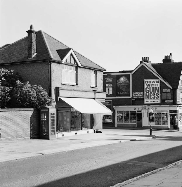
The Post Office still with its rear garden and name fascia A Rankin Smith in 1964.
COURTESY ST ALBANS MUSEUMS

The shops c1960.  The extension being constructed in the garden of The Post Office.
COURTESY JACKIE ALDRIDGE

The trend in the 1930s for a single building combining several shops, and also identified in a recent post, was continued here where three standard width units and a pair of half-sized units were built.  First to open was Percy Hall's hairdresser departments for both women and men.  Mr Hall had previously opened his first salon nearby in Bycullah Terrace and had others around Fleetville at different times.

Recent view of the shop which began as Harpers Motors and later St Albans' Scooters.

When Norman Harper first opened his Motor Sales showroom as late as 1939 the legal documents reveal this block of land had still been in the ownership of the estate of Thomas E Smith from the former printing works opposite.  Although now a phone repair shop the street elevation still has the original bracket arm for frontage lighting; street lighting in the 1930s was still quite poor.

The two half shops began as London Central Meats and a studio photographer.  After the Second War they were Baxter's Butchers and Garrard Fruiterers; and along the sideway to the right was a signwriter's business for S T Broad.

The Post Office with shops beyond.  This is where building activity took place in 1912 to create
Fleetville's cinema. This is the orange block outlined on the second map above, and occupied
a wider plot than had been paid for, according to the court report in the Herts Advertiser.
COURTESY GOOGLE STREETVIEW

A plan and front (Hatfield Road) elevation drawing of the cinema.  Not a single showing
took place, and no sooner was the building up than, by court order, it was taken down.
COURTESY HERTFORDSHIRE ARCHIVES & LOCAL STUDIES

So, where do the flicks come in?  Well, the building came – and went – so quickly that not a single performance took place. Russell Edwards living in Granville Road claimed to be a showman, and saw a business opportunity which wasn't entirely legal and put up a secondhand tin building as a picture house/cinema.  Without using his own funds this serial mischief maker assured an investor that the cinema was already open and operating profitably and attracting patrons in numbers which, in fact, could not possibly have been accommodated.  In fact it was just a pile of tin and iron lying on the ground and the men engaged to erect it were sometimes not paid.  Creditors caused Edwards to be taken to court – again, and the court ordered that the building, so close to opening, should be taken apart and sold to defray court costs.  When did this occur? In 1912, so becoming the first occupier of this block. And where was it?  It all happened on the plot which is still Fleetville Post Office today.  

Sorry you missed the show!

Next time we'll trace the story of the most well known Hatfield Road trading quarter, Bycullah Terrace, and discover the origin of its name.


Wednesday 16 September 2020

For the People of Fleetville

Red: three fields formerly owned by the Grammar School.
Blue: field purchased by T E Smith for the Fleet Printing Works.
Orange: field purchased by T E Smith for his Fleet Ville housing.
Green: Part of the same field left undeveloped and acquired by Charles Woollam.


Recent aerial of the recreation ground during a dry summer period.
COURTESY GOOGLE EARTH

 We have now reached the end of St Peter's Farm where the property boundary lines up obliquely from the main road.  The former fields outlined in red on the above map identifies land which was owned by St Albans Grammar School and managed for it by the Verulam Estate.  The blue field was acquired by Thomas E Smith for his printing works in 1897 and he acquired the green and orange field opposite to lay out a hamlet for his employees.  

Others were also laying out streets and houses nearby on the former St Peter's Farm, and so Smith did not use all of his land – the green part of the field on the north side of Hatfield Road – otherwise there may have been a further street of two of small homes had the demand evolved.  You will see that there were no homes on the west side of Royal Road.

William Bennett, well known in the building trade, had rented at least part of the green field to store building materials, including bricks, which he needed for his construction activities in the Slade building estate.

In 1912 Charles Woollam, mill owner and a trustee of the Grammar School that had sold two of the three fields to Thomas E Smith in order to fund the expansion of the school adjacent to the Gateway, purchased the green field from the Smith estate using his own funds.  He had noted with some concern that Fleetville was growing quickly and no land had been allocated specifically as open space for the use of this district's residents. He gifted this land to the City Council in 1913, the year in which the authority had taken over responsibility for Fleetville from the Rural Council. A covenant protected the use to which it could be deployed, for the recreation of the people of Fleetville in perpetuity.  By name it was initially called Fleetville Pleasure Ground or Playing Field; later became known as Fleetville Recreation Ground, or Rec, but is now sometimes referred to as Fleetville Park.

No sooner had the council prepared the ground, built retaining walls and installed railings (some of which remain in place) than there was a call to dig it up for emergency allotments.  After some disagreements the allotments went instead to the field where Fleetville Junior School is today.

Pre-WW2 family photo, with the school as a backdrop.  This was before the recreation ground
railings were removed on this side.  Today the seat is occupied by part of the front of the
Community Centre.
COURTESY FLEETVILLE INFANT SCHOOL & NURSERY


For the next 25 years the Rec was rather bland with just one set of children's swings near the Royal Road corner (chain locked on Sundays as was the custom in St Albans); and a public toilet block added in 1938, the same year in which emergency zig-zag trenches were excavated in preparation for war.  Gates in the fencing at bottom of Burnham Road gardens enabled quick access to the trenches.  Additional trenches were added in 1939 and 1940 for the benefit of the school; all were deepened to 8 feet, bricklined and covered, and fitted with electricity, heating and telephone.  They were accessed from steel doors at Royal Road with an emergency exit in the rec field, the latter can still be noticed in parched grass in hot dry summers.  A temporary day nursery arrived in 1942 for the benefit of mothers who worked in the munitions factories locally – this building is still in use as the Community Centre.  

A 1939 aerial of the recreation ground in the middle.  The 1938 open zig-zag trenches are visible.
So too is the diagonal footpath between the Hatfield Road and Royal Road gates. Within that
triangle is the new public toilets block and the children's swings.  Also clear is the grass wear from games of football!
COURTESY HERITAGE ENGLAND

The temporary wartime children's nursery, today used by Fleetville Community Centre. The car is
parked where once a ramp and steel door led below ground level to emergency shelters for the
use of children at the school.

Two further installations during the war were an ARP hut next to the newly opened toilets, and an emergency water tank located where the zip wire is today.

Recent photo of the recreation ground without its original pre-war hedge line resulting from
road widening in the 1960s.

Plan prepared by Design Team Partnership in 1989 for a proposed underground car park for 194 cars under the recreation ground.  It would have occupied the southern end, but the proposal was not taken forward.

Post-war the junior children took to using the field for games lessons, but this was frowned on by the city council who wanted their bit field back from the County Council. A line of young trees were planted beside the shops, and in the 1960s a corner of the main road was shaved off and widened on safety grounds; resulting in the loss of the original field hedge with partial replacement of the original boundary wall.  Children living west of the rec will recollect an informal access point via a couple of missing railings next to Andrews' greengrocery.  That short cut disappeared with the improvements!

A scheme came to light in 1989 for a 200-car underground car park with ramp and six emergency staircases emerging at regular points in the field, as well as a number of light wells.  No one appeared to have considered the impact on organised events and team games.  Anyway, the plan was abandoned.

In more recent times there has been activity equipment for children and young people right across the park, and although the toilets were closed a popular cafe and seating area has appeared.

Next time we shall continue moving eastwards to the later developments between Royal Road and Tess Road (now Woodstock Road south). It might have become an entertainment hub!

Saturday 5 September 2020

Hostelry which never was

The Hatfield Road buildings east of Harlesden Road, with the recreation ground east of the
treeline.
COURTESY GOOGLE EARTH

The image at the top of the blog post on 14th August looking east from Sandfield Road, includes developments which took place east of Harlesden Road, but something seemed to be missing, partly because we think we are looking at the recreation ground in the distance; a point mentioned in that post.  In fact, it is future development land which we will come to shortly; the rec is out of sight in that photo.

By 1964, when this photo was taken, the corner grocery shop had become a bank.  The next shop, 
also a grocery has a house between them.  A short line of fir trees marks where a meeting house was
built.  Beyond is Fleetville's first shop parade.
COURTESY ST ALBANS MUSEUMS

But first we will look at the orange block east of Harlesden Road.  There is a detached address which is a shop, on the corner, and a semi-detached pair but both parts now looking very different.  No doubt, when new the semi-detached pair with their little front gardens would have looked smart.  Edward Hanley owned the corner shop  – he also owned and ran a grocery on the south side of Hatfield Road near The Crown. This one at Harlesden Road was managed by James Harrison, baker and confectioner, followed by two more bakers in turn until resumption of peace after World War 1 when Teiji Orihash took over baking and added a grocery.  There are still former residents of the district who recall being taught to play the piano by Mrs Orihash at lessons given on a first floor grand piano.  There is some doubt whether or not Mr Orihash kept his shop open throughout the hostilities after 1939, although the 1942 Kelly's directory still lists the shop.  However, after the war, Mr Orihash thought it prudent to change his name to Hugh Orton in view of potential hostility towards his Japanese origin.  In the mid-fifties number 173 was transferred to Lloyds, the last of the big clearing banks to open in Fleetville.  They had a relatively short presence in Hatfield Road, until the mid-seventies, before the present traders, City Glass, took over, and created another example of additional premises built on the rear garden space.

A snowy scene in the 1930s centred on the house then being occupied by Charles Carter. The
grocery to the right was then under the management of H W Bennett.
COURTESY CAROLYN HAYWARD

The other two premises in the orange block were semi-detached homes until 1911 when the righthand house, number 177, was adapted to become a shop; H W Bennett's grocery, just two doors from the corner shop.  Walter Brooker took over from around 1948, but, as with many other small grocery traders, they suffered from the arrival of the supermarkets.  Brooker's therefore became a television aerials shop, and more recently the latest in trend purchases: vaping.

In the middle there remains one house. Although there have been several occupants, more is known about one of them during the 1930s. Thomas Carter, who had already established himself in the horticultural business, Sear & Carter, near St Paul's Church, encouraged his brother Charles, with an interest in agricultural machinery, to set up business in St Albans.  So, in the early 1930s Charles acquired the house at number 175 and a plot opposite on which he built Carter's Garage.  Later it would became Hobbs' Garage and is now Kwikfit.

Breweries are usually early to lay claim to land in development districts for future public houses.  In 1899 Benskins purchased the red and blue plots in the top picture for a public house, hostelry and carriage yard – presumably similar to The Crown, which was being constructed during the same year.  Directly opposite to Benskins' proposed establishment a competing company, Trust House, acquired a site for a hotel and accommodation for dining and drinking.  This launched a twenty-five year,  acrimonious battle between the two companies and many of the property owners in Fleetville which was only resolved when Benskins transferred its interest to the site on which the Rats' Castle was later built.  But there was no hotel.

In 1924 only the orange block buildings have
been developed. A small and larger plots acquired by
Benskins remain open during the lengthy objections
to the sale of alcohol in the district.
COURTESY NATIONAL LIBRARY OF SCOTLAND

The line of WW1 troops passing the shops, with the 
smaller open plot behind the leading soldiers.  We can also observe where the righthand former
house has been converted into the shop which one day will be known as Brooker's.
COURTESY ST ALBANS MUSEUMS

Benskins land consisted of a small and large plot.  As soon as Benskins felt the opportunity of future trade on this site slipping away, the company was prepared to relinquish the smaller plot, which the Salvation Army purchased.  There are, of course, two possible reasons for this move.  Either the church group wished to construct a citadel, Sunday school or other meetings place, or it was a strategic purchase to squeeze out Benskins.  Well, the Sally Army didn't build, and when the opportunity arose the Mid Herts Bill-Posting Company rented both the small and large sites for advertising.  The small site remained as a poster site until around 1956 when the Plymouth Brethren group, which had previously occupied a small premises in Hedley Road, constructed a meeting house.  When it was no longer required for this purpose c2005 it was replaced by residential accommodation with the design containing echoes of the neighbouring frontages to the east.  Although there had been an option for a ground floor shop in the plan this did not materialise.

The Plymouth Brethren Meeting House built in the mid-fifties on the smaller plot formerly
owned by Benskins and subsequently acquired by the Salvation Army.
COURTESY ROBIN DE SMET

The same smaller plot more recently.  Long gone are the days when the land was used for
displaying large advertising posters.  Unfortunately a photo of that period has not yet been found.

Benskins finally relinquished the large plot (the blue block in the top picture) c1927, and this presented the opportunity for a shop parade of four establishments for the first time in Hatfield Road.  Set further back from the kerb the front elevations were typical of their time, with herringbone brickwork and first floor bay windows.  The original plan was apparently insufficient for the demand even at the time of opening, as the irregular space between the planned development and the boundary with the recreation ground a single floor shop unit was added.  Until the early fifties there were a variety of occupiers, but from 1956 Andrews greengrocery, was opened there.  In 2020 the same family is still trading here.

The five shops shown in 1964 with their frontages and before improvements to the roadway.
COURTESY ST ALBANS MUSEUMS

When retail trading returned to normal after WW2 we should remember that the parade was still young.  In the period up to the mid 1970s the first shop was a confectioner (Dorothy Miles and then her son David Miles. Miss Gurney and then Mrs Wright, managed a ladies' hairdresser. In the third shop was Mr Macpherson, chemist, followed by St Albans' Scooters. A butchery run first by Hedley's and then J Johnson was in the fourth unit.  Andrews greengrocery was and is in the lock-up shop at the end.

However, today the former confectionery, has been converted into residential.  The front elevation, though modern, still respects the original design, although the herringbone brickwork was been lost.

This recent view illustrates the grey frontage of the former first shop now converted into
residential.
COURTESY GOOGLE STREETVIEW

In this series of posts we have found many examples of houses converted into shops as Hatfield Road became a true shopping street; in this post, however, we've drawn attention to a rare example of a shop being converted into a house. Next time, in a break from looking at the built Hatfield Road, we'll pause to provide an insight into the origin of the Recreation Ground, sometimes these days referred to as Fleetville Park.