Wednesday 28 February 2024

Camp

 Last week's blog was about Camp Field, which became Campfield Road, and given that a query was raised by a reader about the origin of the word Camp as a place name, and therefore its connection with Campfield, Camp Hill, Camp Lane and Camp Road, it seems logical to investigate the name of the district itself – Camp.  Where does this name come from and what was its earliest reference?

To justify the name given to the former Camp PH the artist portrayed a camp 
scene with a Roman official in the foreground.  This told the wrong story!

Well, however confusing and uncertain, the name certainly had nothing to do with the Romans.  Erroneously, it has been suggested St Albans began as a Roman city, or Verulamium was formed out of camps set up in much the same way as large infrastructure projects today still require worker encampments.  The former Camp public house hanging sign sported a picture of a Roman soldier, and a modern building on Camp Hill was awarded the name of a Centurion.  To be clear, Camp as a district had nothing to do with the Romans.

An element of civil life in feudal England had for centuries been the maintenance of local militias.  If you have heard of the County Lord Lieutenant one of his (and it was naturally his until modern times) responsibilities was to enhance the militias within his county.  It required an Act of Parliament (the Militia Act 1757) as the Union developed, and as a result required more formal training and places where such training could be carried out.

The militias were not in any way the same as the regular army; they were volunteers, although early muster rolls included lists of local men eligible for active training and service, being called up "when required."  So the degree of voluntary participation undoubtedly varies. The infrequency of their need meant that training was inefficiently – and infrequently – carried out.

The current slopes of Cunningham open space, formerly referred to as Springfield. Here were
gathered volunteers and militia men for ad hoc training exercises during short and isolated periods
of the 18th and 19th centuries; the last such period being in 1915.

In St Albans, Earl Verulam offered land for training purposes; fields on sloping ground adjacent to Cunningham Hill (which is also part of the same topographical feature as Camp Hill, where you climb it from Campfeld Road and the former stream, mentioned in last week's blog. The Camp field itself can still be walked, and viewed from behind Dexter Court where the expanse of Cunningham open space offers views down to London Road.  We are left to imagine how many men were gathered at any one time and for how long, and whether  inhabitants from nearby hamlets were given the opportunity to watch the entertainment.

Men attending training in the 18th and 19th centuries invariably travelled from a wide area and collected at the top of the hill.  It is possible that one or two cottages along the top of the hill were in use by farm labourers working at the nearby farm, and they may have been in use since the early eighteenth century. 

The 1766 Dury an Andrews map is believed to be the earliest to name the location of a 
building named Camp House; the Camp itself being west and south of Cunningham, here
named Garrycomb Hill.
COURTESY HALS


By 1822 a small hamlet had grown.
COURTESY HALS


However, the earliest reference to the word Camp in print was a single building named Camp House standing at the junction with Cell Barnes Lane and Camp Hill on the 1766 Dury & Andrews map.  It is sometimes suggested that Camp House was a public house or beer house.  However, no evidence for this use or name has surfaced, so we are left with the possibility that it was just a solitary house or cottage, which may have provided intermittent refreshment of some kind at times when training camps were organised.  The last known camp used for military training was in 1915, although by that stage many such camps were set up around St Albans.

Images of activity came late, with photos taken during World War One.  Perhaps there were
drawings or paintings from earlier times.

Such training was fairly regular in later militia and yeomanry periods and the location of these camps would have been well known.  Towns occasionally have local names which include the term Camp, either with a prefix or on its own. St Albans does not stand alone.

The need for food required the training field and nearby slopes leading down to London Road
to be utilised as allotments.
COURTESY THE HERTS ADVERTISER

All Ordnance Survey maps from 1822 onward name this little hamlet at the top of the Hill The Camp – note, it was not named A Camp; it was quite specific as this was THE location in the town where the training took place and was therefore The Camp site.

Once the land was available once more it was released for use as an agricultural show ground and during the Second World War for community allotments.  But it has never been utilised for any other kinds of camps – of the leisure variety for example, or for scouts and guides.

But the long lane which began at Hatfield Road and finished at Hill End Lane had a long history as Camp Lane, meaning quite literally the lane which leads to The Camp.

Sunday 18 February 2024

Camp Field


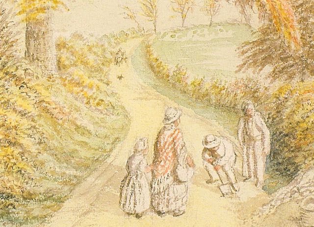
Portion of a scene painted by John Buckingham (1800-1881) near the Camp Field at the foot of
Camp Hill.   Today the Campfield Road/Dellfield road junction is nearby.
COURTESY ST ALBANS MUSEUMS

 Few of us with knowledge of the east side of St Albans will need a reminder of the location of today's blog.  Leaving Hatfield Road at The Crown, descend Camp Road and pass under the Blue Bridge.  At the very lowest ground and before climbing Camp Hill, turn left. This is  Campfield Road.  A small branch railway line arrived in the 1860s (the original reason for the bridge, although it wasn't blue then - in fact not the same bridge at all! The railway separated the growing Hatfield Road to the north from the dairy fields and hamlet of Camp Hill to the south.  The artist John Buckingham, painting in the mid 19th century, portrayed this junction very effectively; the road ahead is Camp Hill. 


OS maps surveyed in 1875, 1897 and 1922.
Field number 427 in 1875 was Camp Field. Between it and field 429 was a footpath between
Camp Hill (The Camp) and the Hatfield road.  The two square buildings on the south side
of Campfield Road (1922) are the Electricity Works and Sphere Works.
COURTESY NATIONAL LIBRARY OF SCOTLAND

On the low-lying land, where Campfield Road is today, there had been a small chalk stream, the same one which had flowed from Marshalswick towards Fleetville before turning across the gently sloping Camp Field towards River Ver.  It is doubtful if much remained of the stream even in the 1860s, but it might have provided one reason a portion of the reason may have eventually been sold out of farming for development.


1930s homes line around half of Campfield Road as well as Valerie Close, Roland Street and one
side of Sutton Road.

We note that the Campfield Road of today is quite lengthy from Camp Lane (now Camp Road) to Sutton Road.  The eastern section is largely semi-detached homes built c1930 by Mr W Stephens for the rental market.  Before that date the field at the eastern end was used by the Oakley family to graze dairy cattle, and for the first decade of the 20th century was utilised as Fleetville's first recreation ground, mainly for the use of of local football teams.  Along the boundary between the upper and lower fields ran a footpath from the oldest section of Camp Hill, downhill towards the stream bed and gently up the opposing slope towards Hatfield Road – opposite where today the western boundary of Fleetville Recreation Ground.

The Miskin built structure as designed for George Orford Smith, including its manager's house
before the site was extended for the Salvation Army's Campfield Press.

The main workshop of the Musical Instrument Works.
COURTESY SALVATION ARMY ARCHIVE

Meanwhile, at the lower end the sale of the water meadow was completed in 1895 to Mr George Orford Smith, who had a sizeable and specialist printing works – thus becoming the first such works in the Fleetville area and relegating T E Smith to second comer by two years.  Orford Smith's works were designed and built by Christopher Miskin & Sons, and included a manager's house.  The company specialised as a fine-art printer, producing high-quality multi-pass colour expensive work for clients, including Illustrated London News.

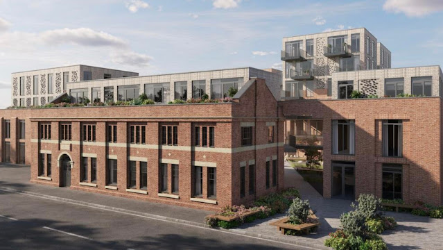
The modified front building of the 1908 Electricity Works for the nearly completed new
residential development.

However, the works remained in business for only five years, and in 1900 an equally expensive winding up process took place and the buildings were sold on to the Salvation Army which moved its printing, and shortly after its musical instrument works, from the East End; that is, London's East End.  The road, or rather track into the field, was called Campfields.  The road's first iteration was barely longer than the works itself.  However, the Salvation Army also acquired additional land, and so it was that the buildings for the city's electricity works was acquired from the Salvation Army's William Booth in 1908.  The administrative building of the works still stands and is now being converted into residential accommodation to be known as The Old Electricity Works.  New buildings for the development have been constructed at the rear on the site of the former generating furnaces.

Advertising by Engineering & Lighting Equipment Ltd
COURTESY GRACES GUIDE TO HISTORY OF INDUSTRY


ELECO's contract along Victoria Embankment.


The next site to be developed, and appropriately next to the electricity works, was an engineering company, Engineering & Lighting Company Ltd (ELECO) which had begun its life in the Lower Lea Valley.  It specialised in the manufacture of electric street lighting.  One of its earliest products was the globe lighting columns along the Victoria Embankment beside the Thames.  It is probable this product prompted the works to be named Sphere Works.  The company also acquired a site opposite, adjacent to the printing works, using land previously occupied by the Salvation Army's tennis courts.


The former Herts Advertiser building, now Phoenix House

After a century publishing a newspaper in the centre of the city the Herts Advertiser moved out to the suburbs, and to a site known to all today as Phoenix House.  In the 1960s the local news was published from here, and although the address is Camp Road, Phoenix lies along Campfield Road leaning against the hill which is Camp Hill.

On both sides of Campfield Road were temporary land uses during the Second World War; on the east side shelters were driven into the hillside; and on the west there were quarters for the Home Guard, and additional temporary buildings; de Havilland Aircraft Company occupied much of the Salvation Army Musical Instrument Works – later taken over by Boosey & Hawkes.

So, Camp Fields, or Campfield Road, a street of two halves; homes on the east and businesses on the west.  Although nothing original remains on the railway side apart from a section of boundary wall, there is plenty of activity in the many industrial and business units which trade from here.  And even more trade on the Sphere Trading Estate opposite.


Sunday 11 February 2024

Gurney Court

 Ah, we're back to Gurney Court again, although the only time it has been featured previously was in connection with the origin of the street's name.  We are not even going there today!  Our visits investigate what might make the road out of the ordinary, different, or even unique.

Gurney Court Road is one of a pair of north-south residential roads (the other being Charmouth Road) built in the 1930s although the proposals for the development predate the First World War. In fact the seeds of development might be traceable back to the 1860s, when the Midland Railway Company was seeking a route to link its line at Bedford southwards to St Pancras via St Albans.  One option, which was not taken forward, was to build through what would later become Fleetville, across Hatfield Road towards Sandridge.  However, the selected route was closer to the eastern boundary of St Albans Borough, through land belonging to Earl Spencer and close to Marshals Wick House owned by the Marten family.

To the right of the Midland Railway are the allotment lands, with the majority of the Marshals
Wick House park on the right side of the map.
COURTESY NATIONAL LIBRARY OF SCOTLAND


The developed parallel roads of Gurney Court and Charmouth roads almost complete for the
1939 published map.
COURTESY NATIONAL LIBRARY OF SCOTLAND


On one side the fields between the railway and the boundary of the Marshals Wick park north of Sandpit Lane became treatable has a block of land distinct from the larger portion north of the railway, as far as Sandridge Road. 

During the early years of the twentieth century allotments became popular, not so much as a leisure time pursuit, but for the health and well-being of residents on limited incomes and living in smaller terraces with only small gardens.  So pathways were laid out and allotments were let out.  The same land was utilised during the First War for military training, and for the storing of building bricks, not to mention the inevitable intensification of food growing.

There were a lot of homes to sell c1936, and a rather optimistic walking time
to reach the railway station.


The final owners of Marshals Wick House were George Nisbet Marten and Anne Marten, and the house was unsuccessfully offered for sale in 1921, some time after the death of George.  However, once it became evident that buyers for the house might be thin on the ground plans for redevelopment were taken forward.  As with other estate and farm land on the edge of the city Earl Spencer disposed of his adjacent three fields for new homes, while ensuring a proper connection was available from Hatfield Road – for the railway station – through both sections of Clarence Road, to link with his new roads north of Sandpit Lane.  His new road layout conveniently followed allotment paths and the detached and semi-detached homes began to appear, starting with those along Gurney Court Road. 

A coordinated plan of Stimpson, Locke and Vince, still will no office in St Albans, laid out the proposed plan for both the estate and the Spencer land, both largely a grid in layout; Gurney Court and Charmouth roads following a typical plan for the time of very lengthy mainly straight roads in parallel.  The houses were mainly grouped according to a builder's choice and the developer's rule on minimum values for the number of plots the builder had  purchased.  So the effect as we walk or drive along the road is of a pleasing design palette  typical of the mid thirties.


Three typical types of home lining Gurney Court Road.


The road with no homes along it: Harptree Way


On the road's eastern side the houses are punctuated by one very short connecting road, Harptree Way, itself having no homes fronting it.  Under the original layout plan Harptree Way would have been significantly longer, extending across Charmouth and connecting with Home Wood Road (now Homewood Road).

Gurney Court Road is on the right; the Midland Railway cuts itself beneath the St Albans Road
bridge.  Marshals Drive and Marshals Drive sandwiched the North Lodge when laid out, although
today Gurney Court Road continues across the unbuilt plot fronting Marshalswick Lane and
is therefore a little longer.
COURTESY NATIONAL LIBRARY OF SCOTLAND


Next to the triangle at the Sandpit Lane end of Gurney Court Road, where it might be thought the first homes belonged to the beginning of the road's sequence, the numbering reveals these to be the rather intermittently located dwellings of Sandpit Lane itself.  At the north end we may observe the road is now a short distance longer than its pre-war distance, having been driven through to Marshalswick Lane.  The road layout of Marshals Drive has been marginally shortened. North Lodge is now at the end of a stopped up Marshals Drive, allowing for a simpler traffic connection into the Sandridge Road/St Albans Road intersection.  The result is, of course, a congested junction at busy periods of the day.

Consider this: if you lived in the bottom third of Gurney Court Road how far away would be your walkable distance to the local shops?  It was not an error that shops were excluded from this development.  Their exclusion was built into the covenants of the estate! Even the later Quadrant shops are quite a step!