Tuesday 20 December 2022

Absent Collection

 During the past two months I have identified for everyone data on a range of buildings which no longer exist, and which from my research no-one thought to photograph, or if they did those pictures have not survived.  We therefore have little or no memory of what they might have looked like.

I've nowhere near finished this collection, but when I do I will offer reminders of buildings no longer existing but where, fortunately, photos were taken and still act as a point of reference for all of us.

Meanwhile, back to the challenge of locating buildings long since gone; not just one this time, but a whole group scattered around our East End.  Smaller than your average house and definitely not intended for permanent occupation; all erected in the late 1930s and demolished at various times in the 1950s.  They were variously street shelters, police cabins, and Air Raid Precautions Wardens boxes.  All constructed using stock bricks and with flat reinforced concrete roofs.

Street shelter surviving until at least the 1980s; not St Albans.

1946 aerial photo centred on Royal Road.  The orange boxed area shows the location of six
street shelters constructed on the west side of the roadway.


Street shelters built on the roadway of a city residential area; not St Albans.

Intending to provide emergency shelter to those caught in the road spaces when bomb warning sirens sounded, the last two surviving street shelters (though these were not actually on a street) remain on Fleetville Rec, part of the present Fleetville Community Centre and serving to protect nursery children and their teachers between 1942 and 1945.  The days of these old structures are now numbered as demolition is imminent, but we are fortunate in having a selection of archive photos, one of which is shown below.

Section of a surviving shelter at Fleetville Community Centre where it had sheltered nursery
children.  Section shows the side opposite the main entrance and the emergency escape hatch
with steps leading to the higher ground.

Among the structures demolished decades ago were street shelters in Beechwood Avenue (near Hatfield Road); Sandpit Lane (junction with Homewood Road); Sandpit Lane (The Wick); Colney Heath Lane (junction with Hatfield Road); Camp Road (junction with Campfield Road); Cambridge Road (junction with present Ashley Road); Clarence Park (football area); Sandpit Lane (junction with Lemsford Road); Royal Road (six in-line in the road space).

Of course, we might query why anyone in the 1940s would bother to take photographs of these rather plain and obviously temporary buildings, especially as most residents or travellers who were persuaded to shelter in any of them, will undoubtedly have negative experiences of the damp, dark and cold conditions, not to ignore how unsafe users might have felt sharing a dark windowless space with complete strangers.  

A police reporting cabin stood at the junction of Beechwood Avenue and Hatfield Road.
A street shelter was constructed nearby just to the left of the photo in Beechwood Avenue.
COURTESY PHILIP ORDE


The first reporting boxes were wooden and introduced in 1935.  The box shown above
was located elsewhere in St Albans, but an identical one stood on the west side of Sutton
Road opposite the Rats' Castle PH and close to the junction with Hatfield Road.  It
survived until replaced by the brick version in the upper picture in 1939.
COURTESY BT ARCHIVE
Police cabins were not so numerous, intending to be a reporting base for duty beat officers to avoid the necessity of returning to the Victoria Street police station at the end of a shift.  These cabins also housed a public telephone accessible from the outside.  Fortunately a photo is in the public domain of the Hatfield Road/Beechwood Avenue cabin before it was taken down.  What does not appear in the record is a photo of the early iteration of this brick box, which is the early wooden version on the Sutton Road/Hatfield Road corner; although the former GPO archive has an excellent picture of a similar cabin in a different district of St Albans.

Air Raid Precautions wardens were also provided with brick built boxes which acted as mini offices and provided with electric light and heating, and a telephone connection.  They were much smaller than a street shelter, but most of their locations have not survived human memory.  The former locations of four are certain: Beaumont School (driveway from Oakwood Drive); Fleetville Rec (next to the public toilets, now Beech Tree Cafe); Marshalls Drive (the Wick); and probably at Oaklands (location unknown).  It is also possible that two others existed, at the junction of Camp Road and Campfield Road, and at Windermere Avenue (where the north side Keswick Close homes are today).

So, the second question which needs answering: why would we need to retain images of these former inconsequential structures?  What value would they have for us now or in the future?  For the same reason former streams which no longer flow on the surface; stands of trees or wider woodlands which have long since been removed for their timber; or missing stone or metal milestones which are now obsolete, replaced by our widespread use of electronic maps and vehicle odometers.  

They represent individual items of the wider story of the district; they form the chapter headings for how life gradually changes as progress continues to be made; or as an immediate response to circumstances inflicted by outside circumstances.  When some of the evidence is permanently lost our understanding of a community is diminished.

So we will maintain our vigilance for the recovery of the historical record, won't we?

Sunday 4 December 2022

Absent photo: Chainbar Toll

 A recurring theme in our range of absent images is turnpike toll payment houses.  Here is another, which probably results from the frailty of such structures even when first erected. and of course the usefulness of their tiny sites once no longer required. It is understandable that photographs would be rare or non-existent; the structures were very basic and once the Reading & Hatfield Turnpike had been taken over as a county road in 1880 there was no further need for the infrastructure.  So we are reliant on the attractiveness of a wider scene for an artist.

This view is from the top of Camp Road. with Stanhope Road on the left; Hatfield Road on the
extreme right.  The house which incorporates Chilli Raj.  At one time this junction was known
as Cure's Corner after the name of an early owner of the shop opposite.


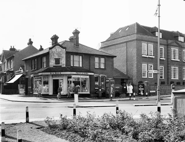
The shop on the site of the former toll house in a photo taken in 1964, before its conversion to a restaurant.  The post box and telephone kiosk stand outside the section of the house next
to the shop.
COURTESY ST ALBANS MUSEUMS


Homing in on the site of today's featured building we recognise it as the Indian restaurant Chilli Raj at The Crown corner, the current building replacing the former tollhouse known as the Chainbar Toll.  An alternative name, the Fete Field Toll, was also in use during its lifetime, taken from the name of the home field of St Peter's Farm nearby.

A feature of sections of the Reading & Hatfield Turnpike was the number of side tolls; that is, locations where payments were made close to the junction of a lane or minor road just before entering the turnpike road.  Although requiring more toll houses and therefore collectors than a system relying only on dividing the main road into sections, it may have been considered more fair to users; perhaps also more profitable for the owning Trust.  From the turnpike trust's perspective it avoided users being able to make use of free sections until reaching the next main toll.

From the OS map surveyed in 1872 is the toll house (circled) near the junction of Camp Lane
and Hatfield Road which curves around St Peter's Farm.  The initials TP stand for Toll Point.
Note that Stanhope Road has not yet been laid.
COURTESY NATIONAL LIBRARY OF SCOTLAND


Throughout the life of the Chainbar Toll there was no Stanhope Road – this was still a cereal field called Hatfield Road field.  Camp Road joined Hatfield Road exactly where it does today, where the Royal Mail posting box is located.  Camp Road was the side road and therefore payment was due to entitle use of the section of the turnpike from that point as far as the Peacock public house at the junction with St Peter's Road.  From then on payment was not required to travel through the city.  The previous main toll was at Smallford – then called The Horseshoes – whose tollhouse was the subject of a recent post.

The next main toll in the St Albans direction was at the Peacock public house drawn in 1865.
It was later replaced by the structure shown below.  It faces Hatfield Road and is at the junction
of St Peter's Road and opposite Marlborough Road.
COURTESY ST ALBANS MUSEUMS


To protect the payment point at the little side toll at Camp Road, a chain was hung across the road from posts on either side.  At certain busy toll points a separate lane was provided for traffic entering the side road since no payment was required, and therefore no chain.  Abuse of this return lane was not unknown and it is presumed that the chain was drawn across this lane at the discretion of the toll keeper.

We know little of the toll keepers whose task it was to collect the fees. Except one, Sarah Gray, who lived in the cottage next to St Peter's Farm homestead on the other side of the Crown junction (where the Conservative Club is located today).  She encountered Thomas Wheeler, who had just murdered Edward Anstee of Marshalswick Farm in 1880.  Her testimony was reported in the Herts Advertiser, and the event would have been a mere matter of weeks or months before the abandonment of the toll system.  Perhaps Sarah was relieved that she would no longer have to face the risks which must have been associated with her role.  

Little detail is available about the toll building itself.  We know it was residential and therefore contained at least one bedroom for permanent occupation.  We also know that it faced directly onto Camp Road and its front looked directly along the line of Hatfield Road eastwards.  The building was also very small.  That's all.

As for when it was demolished the toll house probably remained empty until long after the development of the Stanhope Road estate had begun.  One of the last buildings to go up was an impressive, though not extensive house on one of the then few plots at the eastern end.  The house was built with a detached garage, which was later  converted into a butcher's shop for Mr Bigg, and in the 1960s was  taken over by Mr Holdham.  The house itself was already shown as a Post Office on the OS 1897 map although does not appear to have been converted into a general shop until the 1920s; it incorporated the sub-post office.  Which is why the post box occupies the adjacent spot today – and was once also partnered by a telephone kiosk.

There appears to be no visual evidence of the Chainbar Tollhouse left for us today.  Travelling artists had produced sketches and watercolours, so perhaps one of the Chainbar Toll remains in a collection somewhere.  This junction would have made a delightful scene for artist or early photographer.