Showing posts with label The Crown. Show all posts

Monday, 26 June 2023

The Little Books 3

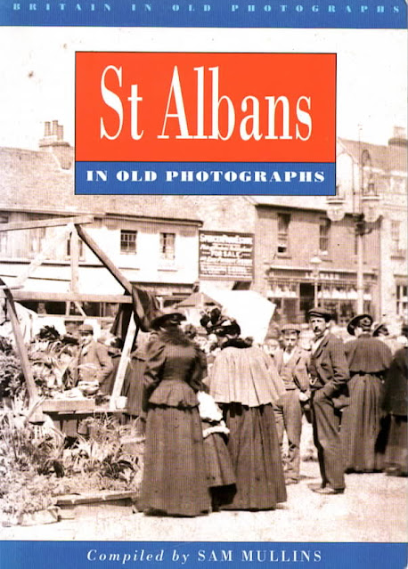
 This week's book takes a step up with the number of photographs laid out, and even selects a few leading images spread across its double pages. The title is St Albans in Old Photographs by Sam Mullins, published in 1994 (ISBN0750901209) within a series under the umbrella of Britain in Old Photographs.  As with previous books in the series we are exploring SAinOP appears not to be in print; however two copies are currently advertised for sale on Abe (www.abebooks.co.uk).


St Albans in Old Photographs not only has a more expansive  selection of images than in the previous two publications, but its division into twelve distinct sections gives more scope for presenting a larger number of themed scenes, recognisable locations, small groups and even individual St Albans' residents. Remembering that our inquiry centres on whether the Eastern districts are fairly represented in the total collection, we should first define those boundaries: any part of the city (the current District) which is east of the Midland Railway.  In the books St Albans' Own East End the historical boundary was the parish of St Peter, but if the author's brief was strictly related to the city boundary this extended to Oaklands and Hill End for the period under review.

Among the sections chosen were A Tour of St Albans, St Albans Abbey, Farming, St Albans Pageant 1907, Roman Verulamium, and Lost St Albans, the latter showing buildings no longer standing, although there are plenty of these among other sections of the book as well.

The first section is titled Market Day, including a super cover image; so the market provides a consistent connection between all three books so far surveyed.


You can almost smell the freshness of Clarence Park – fresh paint, new creosote; the pavilion in the background; the park keeper's lodge with an early sales point for refreshment.

The pavilion may be complete, but finishing groundworks are ongoing, ahead of its 1894 opening.

One section is given over to Clarence Park, so we should be able to tick off all of its contents as being East End based.  There are nine images, of which four feature the pavilion, the most impressive being the completed – and still empty – structure probably taken before the crowds set foot on the place at the very wet opening ceremony.

Of the seven pictures of farming scenes five have captions identifying the locations as St Germains and Verulam Hills, in other words Verulamium.  The two unidentified examples are also likely to be from the same collection.

A footpath has been laid along this view of Sandpit Lane, with the occasional opening onto the lane
from the south side.  On an original print can be detected a large board on posts.  The view
eastwards is from approximately Clarence Road, rising in the distance towards Hall Heath.

Rural Sandpit Lane features in the Lost St Albans section with the oft seen picture of two figures walking along the road space, ignoring  the recently laid footpath. The grounds of Marshalswick House hide on the left, with the future Spencer estate laying in wait beyond the trees on the right.

One photograph, said to have been taken in the Haymarket, London, shows two loaded carts which the caption informs us had been driven there from Butterwick Farm.

A collection of churches is included, of which St Paul's is featured while it is still scaffolded – and fortunately showing off the corner of a paved and metalled Hatfield Road and an all too rare gas street lamp.

The view of Alexandra House, Hatfield Road can be dated to between 1912 and 1914.  Fox's
chemist opened around 1912 and Barclays Bank is first listed in 1914 and may have opened
for business a short time before this.

Finally, the rather impressive Alexandra House at the corner of Hatfield Road and Clarence Road which, when first completed housed a chemist and a branch of Barclays Bank at the Crown corner.

The compiler was provided with a wide range of photographs at his disposal and few of these have appeared in other volumes, and so, as a set, the book contains an impressive collection.

But the fact remains that of 164 photographs of "old St Albans" only 12 could be confirmed as being located in the eastern districts (9 in Clarence Park, and one each from the Crown, St Pauls Church and Sandpit Lane.  A thirteenth was actually a central London view, not a Butterwick view.

While we love Verulamium, the Cathedral and the market, oh, and the city centre shops of course, rather more balance would have been helpful.  So the search is still on to find a Little Book which achieves that balance.

The sources are probably, in the main, from St Albans Museums and HALS.  If not we would be pleased to acknowledge.

Tuesday, 14 February 2023

Crown Fields

 Before launching into this week's group of fields you might like to return to last week's post, Nine. I had intended to add an early Fleetville advertisement for Carter's (Sear & Carter later).  After much searching I have finally located it and it takes its place in the middle of the previous post.  Frank Carter located his shop and the adjacent land in Hatfield Road next to St Paul's Church as Ninefields Nursery.  The site of this property is now St Paul's Place.

IT might take some time to identify your location from the tithe map.
COURTESY HALS


The tithe map with roads named and fields identified.  The text below lists the owners by their
printed colours.
COURTESY HALS


This week there is a far larger group of fields (above) to understand if we are to make sense of the district which launched the development after the 1879 expansion of the city's boundaries, from the previous 1835 Lattimore Road boundary as far as the Midland Railway and Crown junction.

Again I have begun with the 1840 tithe map which, as always, is bereft of helpful text labels; just roads, field boundaries and their numbered references, and properties in grey or pink.  So, the first version at the top is how we start, and once the roads have been identified by their curves, straights and junctions, the names of the fields and their owners can be added.  In this locality there are many owners, identified by colour.  We should wonder whether owners sold up enthusiastically, willingly, or following detailed deliberations and only persuaded after offers of a higher price.

The blue fields were those of William Cotton of St Peter's Farm; the purple fields were owned by Thomas Kinder, but away from his Beaumonts Farm; in red were the fields belonging to Edward Boys.  One field, in grey was owned by Widow Brown, who also had a connection with St Peter's Farm, that field being between today's Marlborough and Lattimore roads.  Of the two major land owners Earl Verulam's presence on the map are in orange, while two fields owned by Earl Spencer (and rented by Thomas Kinder) are shown in green.

The map surveyed in 1872 just a handful of years after the building of the Midland Railway.
COURTESY NATIONAL LIBRARY OF SCOTLAND


Map surveyed in 1897.
COURTESY NATIONAL LIBRARY OF SCOTLAND

Map surveyed in 1922.
COURTESY NATIONAL LIBRARY OF SCOTLAND


The Ordnance Survey map surveyed in 1872, forty years after the tithe map, demonstrates the sheer expanse of railway development once it arrives, and on this map are two; the Midland between north and south and the diagonal route of the Hatfield & St Albans branch line.  By this date street development had grown apace so Boys' fields were quickly lost under houses, as are two of Kinder's.  Locals knew this expansion area as New Town.

By the time the 1897 map was surveyed two further developments had appeared on the eastern side of the Midland Railway, touching and over-reaching the new 1879 boundary.  The field known as Nine Acres (not to be confused with Ninefields from last week) first became a nursery before being purchased by Frederick Sander for the Cavendish estate in 1880.  The opportunity arose as soon as the Midland Railway opened, to develop homes for users of the railway (commuters?).  Therefore, Stanhope, Granville and adjacent Hatfield roads were opened up in the 1880s and 1890s.  Earl Spencer, as with all major landowners, made a profit on his resources, and a field did not need to grow crops if a better income could be made From other outputs.  Land owners are not necessarily farmers.

Meanwhile, three more fields owned by Earl Verulam to the south of the map were also up for grabs.  Twelve Acres quickly became the prison at the same time as the Midland Railway arrived, the remaining land on this field becoming known as the Gaol Field and subsequently developed as the Breakspear estate.

Camp Road today, facing uphill to Camp Hill; the route of the former branch railway passing
overhead (but not on this newer bridge).  Originally the lane followed a line further to the right,
but to provide sufficient height it was diverted eastwards as shown on the 1872 map (above).

Camp Lane, on the lower edge of the map, was diverted by the builders of the branch railway route.  Its two adjacent fields, Dell Field and Up And Down Field were pastured until the 20th century and succumbed to housing development from the 1930s as the Dellfield estate.

It is not difficult to use the tithe field boundaries to compare them with the three Ordnance Survey maps for 1872, 1897 and 1922;  many of those boundary lines are still evident in current roads, tracks and footpaths, the edges of gardens and other properties; a fascinating tracing of the locality's progress through the 19th and 20th centuries.

Sunday, 4 December 2022

Absent photo: Chainbar Toll

 A recurring theme in our range of absent images is turnpike toll payment houses.  Here is another, which probably results from the frailty of such structures even when first erected. and of course the usefulness of their tiny sites once no longer required. It is understandable that photographs would be rare or non-existent; the structures were very basic and once the Reading & Hatfield Turnpike had been taken over as a county road in 1880 there was no further need for the infrastructure.  So we are reliant on the attractiveness of a wider scene for an artist.

This view is from the top of Camp Road. with Stanhope Road on the left; Hatfield Road on the
extreme right.  The house which incorporates Chilli Raj.  At one time this junction was known
as Cure's Corner after the name of an early owner of the shop opposite.


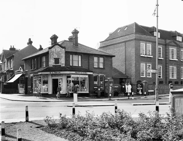
The shop on the site of the former toll house in a photo taken in 1964, before its conversion to a restaurant.  The post box and telephone kiosk stand outside the section of the house next
to the shop.
COURTESY ST ALBANS MUSEUMS


Homing in on the site of today's featured building we recognise it as the Indian restaurant Chilli Raj at The Crown corner, the current building replacing the former tollhouse known as the Chainbar Toll.  An alternative name, the Fete Field Toll, was also in use during its lifetime, taken from the name of the home field of St Peter's Farm nearby.

A feature of sections of the Reading & Hatfield Turnpike was the number of side tolls; that is, locations where payments were made close to the junction of a lane or minor road just before entering the turnpike road.  Although requiring more toll houses and therefore collectors than a system relying only on dividing the main road into sections, it may have been considered more fair to users; perhaps also more profitable for the owning Trust.  From the turnpike trust's perspective it avoided users being able to make use of free sections until reaching the next main toll.

From the OS map surveyed in 1872 is the toll house (circled) near the junction of Camp Lane
and Hatfield Road which curves around St Peter's Farm.  The initials TP stand for Toll Point.
Note that Stanhope Road has not yet been laid.
COURTESY NATIONAL LIBRARY OF SCOTLAND


Throughout the life of the Chainbar Toll there was no Stanhope Road – this was still a cereal field called Hatfield Road field.  Camp Road joined Hatfield Road exactly where it does today, where the Royal Mail posting box is located.  Camp Road was the side road and therefore payment was due to entitle use of the section of the turnpike from that point as far as the Peacock public house at the junction with St Peter's Road.  From then on payment was not required to travel through the city.  The previous main toll was at Smallford – then called The Horseshoes – whose tollhouse was the subject of a recent post.

The next main toll in the St Albans direction was at the Peacock public house drawn in 1865.
It was later replaced by the structure shown below.  It faces Hatfield Road and is at the junction
of St Peter's Road and opposite Marlborough Road.
COURTESY ST ALBANS MUSEUMS


To protect the payment point at the little side toll at Camp Road, a chain was hung across the road from posts on either side.  At certain busy toll points a separate lane was provided for traffic entering the side road since no payment was required, and therefore no chain.  Abuse of this return lane was not unknown and it is presumed that the chain was drawn across this lane at the discretion of the toll keeper.

We know little of the toll keepers whose task it was to collect the fees. Except one, Sarah Gray, who lived in the cottage next to St Peter's Farm homestead on the other side of the Crown junction (where the Conservative Club is located today).  She encountered Thomas Wheeler, who had just murdered Edward Anstee of Marshalswick Farm in 1880.  Her testimony was reported in the Herts Advertiser, and the event would have been a mere matter of weeks or months before the abandonment of the toll system.  Perhaps Sarah was relieved that she would no longer have to face the risks which must have been associated with her role.  

Little detail is available about the toll building itself.  We know it was residential and therefore contained at least one bedroom for permanent occupation.  We also know that it faced directly onto Camp Road and its front looked directly along the line of Hatfield Road eastwards.  The building was also very small.  That's all.

As for when it was demolished the toll house probably remained empty until long after the development of the Stanhope Road estate had begun.  One of the last buildings to go up was an impressive, though not extensive house on one of the then few plots at the eastern end.  The house was built with a detached garage, which was later  converted into a butcher's shop for Mr Bigg, and in the 1960s was  taken over by Mr Holdham.  The house itself was already shown as a Post Office on the OS 1897 map although does not appear to have been converted into a general shop until the 1920s; it incorporated the sub-post office.  Which is why the post box occupies the adjacent spot today – and was once also partnered by a telephone kiosk.

There appears to be no visual evidence of the Chainbar Tollhouse left for us today.  Travelling artists had produced sketches and watercolours, so perhaps one of the Chainbar Toll remains in a collection somewhere.  This junction would have made a delightful scene for artist or early photographer.

Sunday, 19 September 2021

Off to Camp

 In the previous post we finished with a pint at The Crown. Yet the series which has taken us along the south side of Hatfield Road westwards to the Crown doesn't have a clean finish.  For a start, there are shops not yet visited.  We also referred to the little turnpike toll house without providing any detail.  And the Cavendish estate has been extensively referred to without so much as a mention of the houses down the hill in Camp Road; these too are part of the Cavendish estate.

The triangular shaped green space has not yet been built on to provide the homes in
lower Clarence Road (top of map).  Camp Lane (here named Camp Road on the
1898 map) is on a hill leading down to the branch railway and a former stream.
The open space, lower left, is the Breakspear estate, formerly Gaol Field.
COURTESY NATIONAL LIBRARY OF SCOTLAND


The Stanhope Road shops as seen c2012.

The shops and other businesses we have already visited on the corners of Cavendish and Albion roads were the only local ones even after the building of the Stanhope Road villas.  Of those on the north side of Hatfield Road, although built before 1900, many remained houses with tiny front gardens for a few years.  The four shops at the lower end of Stanhope Road were completed in 1901, and provided services for boot repairs, hairdressing, stationery & confectionery, and cycle repairs.  The shop prominently facing the junction, now Chilli Raj , opened in 1905 as a grocery and, later, combining a post office; the latter providing the postal services which were at the height of their social importance.  It is undoubtedly for this reason the red post box came to be placed outside. Before the Second World War the location came to be known as Cure's Corner after one of the shop's owners.  The unit behind this shop, a butchery, was a late arriver from around 1930; previously it had been the garage in the garden of the post office premises.

The former general store and post office.  This is the location of the earlier turnpike toll house
(see small pink building on the map in the previous post).  Stanhope Road, opened in the 1880s,
is on the left and Hatfield Road, onto which Camp Lane opened, is on the extreme right.


The garage built behind the shop was subsequently adapted as a butcher's shop and occupied for many years by Mr Holdham

The general store may well have been constructed at the same time as the villas on the north side of Stanhope Road, had it not taken some time for permission to be granted for the demolition of the tiny turnpike toll house, which was referred to in the previous post – the little pink building on the Hatfield Road curve.  So, how tiny was it?  Difficult to say, but probably a "one up one down", with the ground floor doubling as a private room and a duty room for collecting tolls from vehicle drivers and animal drovers as they arrived from the Camp hill and before they turned onto the Hatfield Road.  Unfortunately the distance covered by the payment took users only as far as the Peacock PH, from whence no further payment was necessary through the city.

There were other side road toll houses at Colney Heath Lane and the Rats' Castle, both of which were small and with thatched roofs; it is therefore probable that the Camp Lane toll house was similarly roofed, although no photograph or drawing of the house has been discovered.

During the lifetime of the turnpike road (Hatfield Road) a number of  road users had discovered a short cut across what is now part of the Breakspear estate onto the later-named Victoria Road and therefore avoided the toll payment altogether.  It is therefore doubtful if there was always a permanent toll keeper; for a time the keeper lived in the St Peter's Farm cottage and walked across the green to the toll house when needed to remove the chain barring access to Hatfield Road.  The final tolls were collected in 1881, coinciding with the development of the surrounding land, which had been an impediment to house building along Hatfield and Stanhope roads.

The view of The Crown PH from Camp Road.


The terraces of Cavendish estate on the Camp Road frontage.  Until the 1920s the land on the left
was an open field and by 1930 was largely built-up.

Homes from the Cavendish estate also lined the hill from The Crown down to Cecil Road on what was then known as Camp Lane until the footpath was laid with the city's typical engineering bricks. Residents living on the lane, as well as those walking from more outlying areas, regularly complained how poor the road surface was, and twenty years later, at the turn of the century, travellers were still complaining.  The terraces and semi-detached homes from The Crown, numbering 18 small properties, hardly reached the junction of Cecil Road, the lower ones having rear gardens reaching Albion Road behind, there being insufficient space for a full row of homes in Albion Road itself.  The front rooms of the terraces of Camp Lane all had a view across to the Gaol Field which climbed uphill towards the path connecting with Grimston Road.  This field was finally developed in around 1930 and known as the Breakspear estate.

In the space of fifty years development had enveloped The Crown, swept uphill towards the prison and towards the new railway station; and flowed downhill beyond the branch railway bridge and along Campfields.  St Albans has hardly paused in its expansion since.

Sunday, 12 September 2021

The Crown that Moved

 When the Cavendish estate was first built there was a pair of shops west of Albion Road, although by the time they had opened most of the nearby homes were occupied; so too were the villas of Stanhope Road, soon to be followed by the homes of Clarence Park Road.

The photos below show the two shops in their early days; both were owned by Edward Hanley whose home was in Lemsford Road.  On the corner was Aberdeen House, a butchery managed by various specialists, including Mr Steabben, followed by Harry Patience of Popefield Farm.  At the foot of Cavendish Road was a small abattoir which if the building had still extant would be within the curtilage of Ss Alban & Stephen Junior School.

The name of Harry Patience only appeared above the door of Aberdeen House for a very short time,
in the early 1920s.  It is presumed Mr Patience is one of the two gentlemen at the door.
OWNER OF PHOTO UNKNOWN

Next door was the Park Stores owned by E Hanley.  Both shops had projecting display windows
in the early period.  The picture below shows the early interior of the Park Stores.
OWNER OF PHOTO UNKNOWN

Next to Aberdeen House was Park Stores, which had the name E Hanley above the door.  But that did not mean that he put in a full shift behind the counter.  Mr Hanley owned several shops, including three in Fleetville, and installed a manager for each one, while he organised the ordering of stock.  Where a manager did not require the upstairs flat, Edward Hanley rented that out.  In the period before shops arrived on the north side of Hatfield Road, Mr Hanley's shops very much complemented those at the lower end of Stanhope Road, even though they had opened rather later.

If you have passed by this part of Hatfield Road recently you may have noticed that the former Hanley's Stores is now a shop no longer and the conversion to domestic accommodation has been achieved sympathetically.  Menspire and the refurbished house and its railings frontage has created a welcome improvement to this corner.

Above: the pair of shops in around 1910
Below: the current street presentation of these two properties COURTESY GOOGLE STRRETVIEW


The street view of the above pair of shops in 1964, the pair of Charlton Villas, and the former 
coachman's accommodation of the Crown Hotel converted into Martell's coal business.
COURTESY ST ALBANS MUSEUMS

Next along the road is a pair of homes called Charlton Villas, erected at the same time as the adjacent shops, for Samuel Collins.  Both number 150 and 148 have always been residential, although for fifty years Arthur Evans ran his plumbing and decorating business from number 148. 

A recent view of the Crown Public House, although the two gabled sections are now paint washed
over the bricks.

The Crown Hotel c1914 with the roundabout in front and surviving tree from the site's nursery days.
COURTESY ST ALBANS MUSEUMS

The remainder of the block as far as Camp Road is taken up by the substantial buildings of The Crown Hotel and public house.  The licensing of this house was made possible by the acquisition of the license of the Rose & Crown in Holywell Hill; today the Abbey Flats are on that site.  In fact there was an occasional slip-up in reporting which referred to the new Hatfield Road establishment as the Rose & Crown.  The business was taken on by Luton Ampthill company Morris & Company, and rather helpfully its name has been added to the 1912 revision of the Ordnance Survey map.  However, it seems that the plot had first been acquired by John Green of Bedford.

The 1872 Ordnance Survey shows the bend near St Peter's Farm and Camp Lane meeting it
from the bottom of the map and passing the tiny toll house – the small pink building – with Ninedells Nursery to its right.
COURTESY NATIONAL LIBRARY OF SCOTLAND

To understand the placement of the Hotel in relation to the road layout we need to refer to the 1872 Ordnance Survey.  As we walk past the hotel's former stables and groom's quarters – later converted into Martell's Coal Sales and now private accommodation – the footpath deviates to line up with Stanhope Road ahead.  Such a property boundary dates from the sale of the former Ninedells Nursery and the sale of Hatfield Road Field for the development of Stanhope Road.  Before that time, as shown on the 1872 map, Hatfield Road's notorious bend to the right had the junction with Camp Lane shortly after the turnpike chain toll point.  This is the small pink building near the letters TP on the map.  Until the nursery was sold its boundary met the Hatfield road at the bend.  It is likely that the large tree shown in front of the c1914 photograph is a boundary survivor of that nursery.  To enable vehicles travelling westwards to access Stanhope Road a slip lane was made in front of the hotel.  In effect this created a roundabout.  Although it is not clear when this was closed off it was probably with the growth of motor traffic in the 1920s.  

Along with this great photograph it is worth pondering on two further points.  Unfortunately hidden by the tree, the original hotel name was displayed above the ridge tiling and between chimney stacks.  Such a position demonstrated the prominence of the hotel's position along the main road.  Secondly, on the edge of the roundabout is a cabinet with the city crest on the front.  Place there c1908 it was an early electrical connection box from the supply cable laid from the generation works in Campfield Road.

Now the Crown Public House, we can rest with a pint in the beer garden, and join regulars on televised football evenings.  It is the last pub eastwards along this road until the Rats' Castle.

Wednesday, 11 August 2021

Outside the boundary

 In the previous post we had reached the western boundary of the Hatfield Road Cemetery on our walk towards The Crown.  St Albans had remained fairly constrained until the arrival of the Midland Railway when development produced estates which took advantage of the new mode of transport.  The boundary of the town was stretched to land at Cavendish Road in 1879, although there is no sign of the boundary marker today, possibly removed when the 1880s Cavendish estate was created.  Houses on the estate strode over the new "edge" no sooner than the boundary had been plotted on the town's maps.

The Lucern Field and Nine Field which made up Ninedells nursery, bounded by Hatfield Road (top), Camp Road (left) and branch railway (bottom right corner).  The nursery drives appear to have
become repurposed as Cavendish Road and Albion Road.
COURTESY HALS

The pair of fields which lost its green functions first lay between the former Kinder field, by 1880 being prepared for use as a civic cemetery, and Camp Road.  The tithe map of 1840 names them as Lucerne Field and Nine Field and together they had extended to the Camp Fields (now Campfield Road) until the branch railway arrived and sliced away the lower end.

Ordnance Survey map 1897 shows Sander's nursery below Cecil Road and fully occupied. 
The housing estate, begin in the early 1880s is shown significantly fully built.
COURTESY HALS

Until the 1870s these fields were used by John Watson as a nursery, mainly for the propagation of shrubs and trees.  They were acquired by Frederick Sander in 1878 for his expansion of the orchid business he ran from premises in George Street.  Sander created his specialised orchid nursery on the lower section between Cecil Road ad the railway – he probably wished he had reserved rather more space given the success of the operation!  The remaining portion between Cecil and Hatfield roads was developed for housing, the profit from which was used to help pay for the nursery.  Cecil Road connected two parallel streets, Cavendish and Albion roads, and although the layout was intended for houses a few commercial premises found their way here, especially along Albion Road.

Rose Cottage with its name tablet just visible to the right of the upstairs bay window.  The
cemetery is to the left.  The photo was taken in 2012.

Our focus is along Hatfield Road, with space for four premises between the cemetery hedge and the newly laid Cavendish Road: Rose Cottage and the three Horndean Villas, now numbered 176 to 170.  The name Rose Cottage was appropriate in the early days, for until around 1904 it was a modest house on the very edge of countryside, with a larger first floor to allow for the passage of carts or small carriages into space at the rear, occupied by a stable and cow house.  Upstairs were four bedrooms with a parlour, scullery and kitchen on the ground floor.

After twenty years the opportunity was seized by Edwin Seymour who acquired the cottage and converted it into a monumental mason's business.  Since the 1950s it has variously been Fireplace Services, a machine tools business and Radio Rentals, before returning to domestic occupation.

The three Horndean Villas pictured in 2012, designed with attic accommodation.

Here is just beyond the easternmost boundary of St Albans c1912 and in a few years after the 
Horndean Villas were completed (far right) right on the edge of the expanding urban area,
Fleetville has spread all the way to Beaumont Avenue.  The narrow road continues into the
distance and would not be widened beyond Rose Cottage, with the removal of the trees,
until the 1930s.
COURTESY HALS

The hill descending to The Crown junction, still in its unwidened state.

Next are the three Horndean Villas, on land purchased by and built on by John Gurney from London Colney.  Although at various times owners had carried on business such as a house agent, insurance agent, decorator and furrier, the villas have remained splendidly unconverted.

Because of its early development it has remained the section of Hatfield Road impossible to widen as Fleetville grew.  Inexplicably, in spite of the volume of traffic parking is still permitted, and this on the approach to a complex light-controlled junction.

Aerial photo of the Cavendish estate today.  The cemetery is on the left; The Crown PH
is the large building behind the grassed frontage on the extreme right.
COURTESY GOOGLE EARTH

Next time we will follow the changes which have taken place between Cavendish and Albion road.


Sunday, 7 February 2021

Park View

 In the previous post we virtually walked along Granville Road, one of the three roads which formed the 1880s residential development of Hatfield Road field.  At the Hatfield Road end of this road the residents had been given the benefit of their own entrance to Clarence Park once that had opened in 1894.  That gate is now blocked off, but from the perimeter path in the park it is still possible to to see where it was.  And that would have been quite a steep ramp from Hatfield Road.

Hidden behind the foliage is the former gate opposite Granville Road.  Today the old ramp has been
made steeper than the old path.

Where the Hatfield Road Bridge park entrance is the maximum height of the embanked road, and the timber zig-zag pathway before it was replaced recently.


Keep walking along the perimeter path towards the Midland railway and the surface of Hatfield Road on your left keeps climbing towards the bridge.  That helps us to understand how several of the Clarence Villas were built.  There had been little difference in the elevation of the land in what would later become the park – still the fete field in the 1860s – and that in the Hatfield Road field; just a gentle gradient.

In fact gradients play a key part in The Crown corner. Hatfield Road drops down from Cavendish Road to the Crown junction.  Turn left and there is a further fall through the entrance into Camp Road; turning right into Stanhope Road and the gradient increases, only levelling out beyond the Stanhope Road shops.  If you had walked along Hatfield Road from The Crown towards the city before the mid 1860s the ground would have been quite level until you reached the beginning of the city hill, where is the original Loreto College building.  Undertaking the same walk today would be very different, with a long steady climb to the bridge and then down again westwards past Lemsford Road; notice too the steep gradient turning left into Beaconsfield Road.  All of our route would be on made-up ground.

Just five years after the railway opening the embanked Hatfield Road (where the number 412.092 is on one side and the blue lake on the other) shows where the subsoil was placed. Beaconsfield Road is where the line of trees is drawn on the map.
COURTESY NATIONAL LIBRARY OF SCOTLAND


Hatfield Road between the bridge and The Crown junction with the embanked road on both
sides.  It is presumed the Nursery was to stabilise the ground before the villas were built.
The road leading towards the Goods Shed is today's Station Way.
COURTESY NATIONAL LIBRARY OF SCOTLAND

Much heavy manual work was undertaken in removing subsoil from the railway cutting and creating an embankment on both sides of the railway in Hatfield Road to enable traffic to pass over the bridge; it is that embankment we noticed when we took the perimeter path in the park.


Two views of the upper row of villas. To the right of the top view it is possible to spot the rear garden space is below road level.
Top view: COURTESY GOOGLE STREET VIEW

So, what has this to do with the Clarence Villas in Hatfield Road?  Look carefully and the architect has taken a design opportunity with those villas west of Granville Road. They were built with a lower ground floor – the original ground level – with a short flight of steps up to the front entry at first floor level above the new street level.  Although the front view from the lower floor would have been limited to the the embankment itself, the rear garden would have opened directly from the rear living space.  Extra living space without the expense of excavating deeper foundations.

The OS map of 1898 with the undeveloped plot (orange) in the middle of the
lower group of villas. A track from Hatfield Road leads to a narrow building 
against the rear boundary.  In a few years this would become the first site of
W O Peake Ltd, the coat manufacturer.
COURTESY NATIONAL LIBRARY OF SCOTLAND

Between The Crown junction and Granville Road building development had been slower and the infill from the railway had been levelled out, providing for much easier house building.  Today we only have map evidence as none of the original homes survive.  But you will notice there is a large plot in the middle with a path leading from the road to a narrow building against the rear of the plot, much as we find in other occasional unfinished streets.  If anyone has an idea about the function of these narrow boundary buildings the author would be pleased to know.

In the same location as the 1898 map above, the Peake's factory has consumed the whole of
the Hatfield Road frontage and has built deep into Granville Road.  This is the OS 1963 map.
COURTESY ORDNANCE SURVEY OLD OS MAPS

In 1911 Mr William Peake moved onto the middle plot with the intention of making coats.  And the rest, as they say, is history; a history which came to dominate this part of Hatfield Road, and St Albans itself. Too detailed for this post and definitely requiring a blog all to itself.

Monday, 11 January 2021

How Safe Was Hatfield Road?

 The main road through Fleetville was, until c1880, a toll road (the Reading and Hatfield Turnpike).  There were undoubtedly a number of accidents along its length westwards of Hatfield when its condition and visibility was poor, and width inadequate.  But at least there were few local users – who would want to live along a road where you had to have your friends pay to visit or to have deliveries made?  There were, as a result, no homes beyond St Peter's Road.

There were few rules of the road in the early 1900s and vehicles might be permitted to travel as fast as 10mph.  Signs might be placed anywhere (with plenty of time to read them) and councils could justify any number of pedestrian crossings.  But these freedoms and responsibilities did little to control the number and seriousness of accidents, and two notorious locations at the western and eastern limits of Fleetville were the scenes of many vehicle conflicts where speed was not the issue.

Ashley Road/Beechwood Avenue did not appear on accident stats until the 1930s as neither existed; today neither road would be permitted to join Hatfield Road unless the latter had been straightened first.  That might have been possible at the time, but no authority was given to the county to pay for the land acquisition and road improvements.  So, until the 1960s when traffic lights were installed, the exit from Ashley Road was blind to the right.

Bus and van crash outside the general store at the Crown Junction in 1935.
HERTS ADVERTISER
At The Crown end the traffic movements were even more complicated.  Camp Road drivers might turn into Stanhope Road or proceed to Hatfield Road, but had to watch for users of an early roundabout outside The Crown itself.  From Clarence Road drivers had to look left, ahead and right.  In the latter direction, as with Ashley Road, there was no visibility down Hatfield Road at all until the Council decided to move the park fencing back to remove the triangle at this point. Early double-deck buses sometimes lacked the stability of our more modern counterparts, and the varied cambers and gradients at the junction occasionally resulted in an overturning. When Stanhope Road was tree-lined – yes, there was a time – overhanging branches sometimes made contact with bus tops.  Round the corner in Camp Road those same buses also made contact with the railway bridge (not the present blue one but an earlier version with a brick arch). Of course, only single deckers should have been on the route, but injuries did occur.

After a collision in 1931 a bus is shunted into Camp Road beside the shops in 1931.
HERTS ADVERTISER

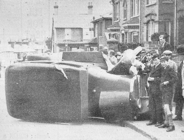
A car on its side in Hatfield Road above the Crown junction in 1929, and attracting much interest.
HERTS ADVERTISER
Oversized trucks, either by height or width, also blocked passage at the former Sutton Road railway bridge.  Many side scrapes have occurred along the narrow section of Hatfield Road between Laurel Road and The Crown, even in recent times.

The reason for widening next to the recreation ground in the 1960s was the number of accidents when visibility was poor around the  bend opposite West & Sellick (now CAMRA) and street lighting was still the pre-war installation.  Thick fogs were also quite common before the Clean Air Acts.  Heavy road rollers and steam carriers were known to be hazardous, especially those hauling trailers, or  those which unexpectedly off-loaded loose barrels, and especially vehicles which were attractive to small children nearby.  Sudden noises might frighten horses pulling carts or wagons and cause them to run away with their tow.

A delivery van made it too literal at the Co-op grocery in Blandford Road in 1933.
HERTS ADVERTISER
Although Camp Road was somewhat quieter, accidents were just as prevalent.  The early road was poor in condition in places, and in at least two places tree banks blocked part of the road near the school and at the former Oakley's dairy farm.

Today's traffic flows may be substantially busier and kerbside parking potentially more dangerous, but perhaps most of us are  better trained for driving and negotiating other road users.  That must count for something.