Showing posts with label Camp Road. Show all posts

Sunday, 19 September 2021

Off to Camp

 In the previous post we finished with a pint at The Crown. Yet the series which has taken us along the south side of Hatfield Road westwards to the Crown doesn't have a clean finish.  For a start, there are shops not yet visited.  We also referred to the little turnpike toll house without providing any detail.  And the Cavendish estate has been extensively referred to without so much as a mention of the houses down the hill in Camp Road; these too are part of the Cavendish estate.

The triangular shaped green space has not yet been built on to provide the homes in
lower Clarence Road (top of map).  Camp Lane (here named Camp Road on the
1898 map) is on a hill leading down to the branch railway and a former stream.
The open space, lower left, is the Breakspear estate, formerly Gaol Field.
COURTESY NATIONAL LIBRARY OF SCOTLAND


The Stanhope Road shops as seen c2012.

The shops and other businesses we have already visited on the corners of Cavendish and Albion roads were the only local ones even after the building of the Stanhope Road villas.  Of those on the north side of Hatfield Road, although built before 1900, many remained houses with tiny front gardens for a few years.  The four shops at the lower end of Stanhope Road were completed in 1901, and provided services for boot repairs, hairdressing, stationery & confectionery, and cycle repairs.  The shop prominently facing the junction, now Chilli Raj , opened in 1905 as a grocery and, later, combining a post office; the latter providing the postal services which were at the height of their social importance.  It is undoubtedly for this reason the red post box came to be placed outside. Before the Second World War the location came to be known as Cure's Corner after one of the shop's owners.  The unit behind this shop, a butchery, was a late arriver from around 1930; previously it had been the garage in the garden of the post office premises.

The former general store and post office.  This is the location of the earlier turnpike toll house
(see small pink building on the map in the previous post).  Stanhope Road, opened in the 1880s,
is on the left and Hatfield Road, onto which Camp Lane opened, is on the extreme right.


The garage built behind the shop was subsequently adapted as a butcher's shop and occupied for many years by Mr Holdham

The general store may well have been constructed at the same time as the villas on the north side of Stanhope Road, had it not taken some time for permission to be granted for the demolition of the tiny turnpike toll house, which was referred to in the previous post – the little pink building on the Hatfield Road curve.  So, how tiny was it?  Difficult to say, but probably a "one up one down", with the ground floor doubling as a private room and a duty room for collecting tolls from vehicle drivers and animal drovers as they arrived from the Camp hill and before they turned onto the Hatfield Road.  Unfortunately the distance covered by the payment took users only as far as the Peacock PH, from whence no further payment was necessary through the city.

There were other side road toll houses at Colney Heath Lane and the Rats' Castle, both of which were small and with thatched roofs; it is therefore probable that the Camp Lane toll house was similarly roofed, although no photograph or drawing of the house has been discovered.

During the lifetime of the turnpike road (Hatfield Road) a number of  road users had discovered a short cut across what is now part of the Breakspear estate onto the later-named Victoria Road and therefore avoided the toll payment altogether.  It is therefore doubtful if there was always a permanent toll keeper; for a time the keeper lived in the St Peter's Farm cottage and walked across the green to the toll house when needed to remove the chain barring access to Hatfield Road.  The final tolls were collected in 1881, coinciding with the development of the surrounding land, which had been an impediment to house building along Hatfield and Stanhope roads.

The view of The Crown PH from Camp Road.


The terraces of Cavendish estate on the Camp Road frontage.  Until the 1920s the land on the left
was an open field and by 1930 was largely built-up.

Homes from the Cavendish estate also lined the hill from The Crown down to Cecil Road on what was then known as Camp Lane until the footpath was laid with the city's typical engineering bricks. Residents living on the lane, as well as those walking from more outlying areas, regularly complained how poor the road surface was, and twenty years later, at the turn of the century, travellers were still complaining.  The terraces and semi-detached homes from The Crown, numbering 18 small properties, hardly reached the junction of Cecil Road, the lower ones having rear gardens reaching Albion Road behind, there being insufficient space for a full row of homes in Albion Road itself.  The front rooms of the terraces of Camp Lane all had a view across to the Gaol Field which climbed uphill towards the path connecting with Grimston Road.  This field was finally developed in around 1930 and known as the Breakspear estate.

In the space of fifty years development had enveloped The Crown, swept uphill towards the prison and towards the new railway station; and flowed downhill beyond the branch railway bridge and along Campfields.  St Albans has hardly paused in its expansion since.

Monday, 31 May 2021

A Better Entrance

This week we pause to consider a few of the issues which come about when a site is purchased and a note on a planning map: "future school", or in the case of Hatfield Road "future schools".

Whether primary or secondary there was a huge difference between what was provided in an educational building. In today's terms the facilities to be found in the pre 1902 Board schools or the later elementary establishments can be considered very basic , where even effective winter heating might be absent.  The County Council, on its formation, became responsible for building and maintaining schools where they were needed.  In the early years after formation in 1889 the Council engaged an architect for each individual school, but in the 20th century it set up an increasingly sophisticated architect department to develop standards common to groups of schools; and these standards developed and improved with time.

The Rural School Board were responsible for creating a school for the widely-spread child
population in surrounding hamlets.

So, using just a few select examples, what did we discover from actual experience?

You would have thought a mains water supply was a basic requirement, but Camp Elementary School was opened without a water supply extended this far from the nearest supply; and in Sandridge senior boys were detailed to carry water buckets from the village pump when required.

In 1908 (Fleetville Elementary School) lavatories were strictly outside at the far end of the playground; and the playground surface was gritted.

When the land was purchased for senior education in Fleetville the space was deemed sufficient for one boys' and one girls' school.  Ten years later when the girls Central School was built only one school could be accommodated.

The County Architect Department developed a building style with interchangeable components
This style of building is widely distributed across the county.  Staff at Beaumont Boys' School
in 1959.

By 1938 when the two senior schools were required even more urgently, Beaumont got its pupils in one building, girls upstairs and boys on the ground floor, with the absolute minimum of sharing!  Playing field space, according to the government, was required to be even greater.  The site reserved for a girls' grammar school in Brampton Road was instead used for a boys' school, while new housing hemmed the school in on all sides.  The regulations required more playing field acreage for boys than for girls; which is why the pupils of the Boys' Grammar School (now Verulam) have, since 1938, walked to their remote site in Sandpit Lane, and continue to do so.

A hall was multi-purpose in the early days, with a requirement to divide into two classrooms, even in the 1920s (London Colney).  It must also double up as a gymnasium in 1930 (Central).  Even Beaumont (1938) was in build when the next advance came, and a separate gymnasium with changing rooms became a new requirement.  This facility was also added to Central later.

When Beaumonts Girls' and Boys' Schools were designed a gymnasium what not required 
separate from the hall.  This new requirement was added as the schools were nearing completion.
Changing rooms were included.  When more modern sports hall facilities were later built the 
gymnasium was converted into a library centre.

From 1930 a platform suitable for drama was added to the hall at Central, and at Townsend an adjacent room was included for teaching and changing purposes, and by 1938 (Beaumont) two small classrooms were added for changing rooms.  Similar improvements were made for staff facilities and administration.  And considering many school still closed at lunchtimes down to the 1920s, catering facilities weren't added until post-war with many schools being supplied from central kitchens elsewhere in the city.

A detached house was included when required for the caretaker and his/her family.  This is at the Fleetville Juniors site, formerly Central, Girls' Grammar, Beaumont Girls, Sandfield; all names
applied to schools occupying the Hatfield Road school site since 1931.  The house no longer
serves its original function.

When schools might be built further away from the urban area and where caretakers need to be close at hand, the authority either acquired a nearby house or had one built in a part of the site.  This added provision was in place by the mid 1930s (Central – detached house), Marshalswick  (bungalow in 1959) and St Albans College (flat in 1959).

The main entrances to schools were also given a more prominent statement where possible.  Central was added in 1937 when the caretaker's house was built.  The need for parking, visitors, staff and other vehicular pressures often limited the possibilities, and Beaumont was only significantly improved within the last two or three years.

Camp and Fleetville schools have had to squeeze more onto their fixed plots even, in Camp's case the removal of a former head teacher's house, and in both cases removal of part of the schools' infrastructure onto new sites (Fleetville Juniors across the road onto Central,  overcrowding of Camp to form Windermere, and overcrowding of Fleetville to form Fleetville Extension School, renamed Oakwood).

Monday, 11 January 2021

How Safe Was Hatfield Road?

 The main road through Fleetville was, until c1880, a toll road (the Reading and Hatfield Turnpike).  There were undoubtedly a number of accidents along its length westwards of Hatfield when its condition and visibility was poor, and width inadequate.  But at least there were few local users – who would want to live along a road where you had to have your friends pay to visit or to have deliveries made?  There were, as a result, no homes beyond St Peter's Road.

There were few rules of the road in the early 1900s and vehicles might be permitted to travel as fast as 10mph.  Signs might be placed anywhere (with plenty of time to read them) and councils could justify any number of pedestrian crossings.  But these freedoms and responsibilities did little to control the number and seriousness of accidents, and two notorious locations at the western and eastern limits of Fleetville were the scenes of many vehicle conflicts where speed was not the issue.

Ashley Road/Beechwood Avenue did not appear on accident stats until the 1930s as neither existed; today neither road would be permitted to join Hatfield Road unless the latter had been straightened first.  That might have been possible at the time, but no authority was given to the county to pay for the land acquisition and road improvements.  So, until the 1960s when traffic lights were installed, the exit from Ashley Road was blind to the right.

Bus and van crash outside the general store at the Crown Junction in 1935.
HERTS ADVERTISER
At The Crown end the traffic movements were even more complicated.  Camp Road drivers might turn into Stanhope Road or proceed to Hatfield Road, but had to watch for users of an early roundabout outside The Crown itself.  From Clarence Road drivers had to look left, ahead and right.  In the latter direction, as with Ashley Road, there was no visibility down Hatfield Road at all until the Council decided to move the park fencing back to remove the triangle at this point. Early double-deck buses sometimes lacked the stability of our more modern counterparts, and the varied cambers and gradients at the junction occasionally resulted in an overturning. When Stanhope Road was tree-lined – yes, there was a time – overhanging branches sometimes made contact with bus tops.  Round the corner in Camp Road those same buses also made contact with the railway bridge (not the present blue one but an earlier version with a brick arch). Of course, only single deckers should have been on the route, but injuries did occur.

After a collision in 1931 a bus is shunted into Camp Road beside the shops in 1931.
HERTS ADVERTISER

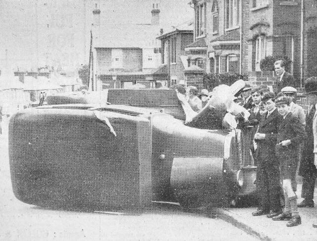
A car on its side in Hatfield Road above the Crown junction in 1929, and attracting much interest.
HERTS ADVERTISER
Oversized trucks, either by height or width, also blocked passage at the former Sutton Road railway bridge.  Many side scrapes have occurred along the narrow section of Hatfield Road between Laurel Road and The Crown, even in recent times.

The reason for widening next to the recreation ground in the 1960s was the number of accidents when visibility was poor around the  bend opposite West & Sellick (now CAMRA) and street lighting was still the pre-war installation.  Thick fogs were also quite common before the Clean Air Acts.  Heavy road rollers and steam carriers were known to be hazardous, especially those hauling trailers, or  those which unexpectedly off-loaded loose barrels, and especially vehicles which were attractive to small children nearby.  Sudden noises might frighten horses pulling carts or wagons and cause them to run away with their tow.

A delivery van made it too literal at the Co-op grocery in Blandford Road in 1933.
HERTS ADVERTISER
Although Camp Road was somewhat quieter, accidents were just as prevalent.  The early road was poor in condition in places, and in at least two places tree banks blocked part of the road near the school and at the former Oakley's dairy farm.

Today's traffic flows may be substantially busier and kerbside parking potentially more dangerous, but perhaps most of us are  better trained for driving and negotiating other road users.  That must count for something.