Showing posts with label Ashley Road. Show all posts

Saturday, 15 October 2022

Absent photo: Brickworks Cottages


Ashley Road crosses between Hatfield Road and Camp Road (left to right).  Brick Knoll Park is
the industrial estate occupying the majority of the photo on the site of the former brickworks.
Cambridge Road meets Ashley Road in the lower part of the image.
COURTESY GOOGLE EARTH

This week we are travelling southwards from Hatfield Road along Ashley Road.  It is a busy highway, a section of the formerly named ring road, and that part of it as far as the bridge was laid out in the 1930s, intended to connect the homes of the Willow estate.  However, the entirety of the route from Hatfield Road to Camp Road had previously been part of a private farm track, with certain permissive rights from 1899 when parts of Beaumonts Farm was sold.  It was known locally by some as the Cinder Track and by others as the Ashpath.  The bridge referred to above, though not the same structure as exists today, was an occupation bridge carrying the farm track over the Hatfield & St Albans Railway (now Alban Way).

Land to the east of the track was believed to have been dug in the late 19th century on a small scale for its clay and used for making bricks.  When the wider area was sold in 1899 this field was specifically marketed for its brick making opportunities.  The brickmaking firm of Fenwick Owen, with existing interests at sites in Welwyn, acquired the field along this track, which today is an industrial estate.  Two parallel roads on the west side of the track, Hedley Road and Cambridge Road, were being developed in the early 1900s although a narrow band of land close to the track was also dug, its clay being taken across to the main works on narrow gauge rail wagons.

Early postwar aerial photograph viewed from above Hill End Hospital towards north-west.
HR = Hatfield Road; CR = Cambridge Road; AR = Ashley Road; HEL = Hill End Lane
red broken line = former Ashpath/Cinder Track; yellow circle = former hump back bridge
green circle = Brickworks Cottages
The major brick making focus grew on the east side; the kilns sited close to the railway leading to a small loading area for the finished products to be removed by train. But the larger area was gradually dug for the clay.  The temporary wagon tracks laid on both sides of the Ashpath transported the raw material to the brick shaping shop  and then to the kilns.  All bricks output from this site were impressed with the letters OSTA (Owen St Albans).

In 1899 when the site was set up this was very much a rural business, with the nearest residential development at The Crown in one direction and a few homes at The Horseshoes in the other.  North and south was open country other than isolated farm houses.  Owen's therefore took the decision to build a group of three cottages at the works for resident employees.  


Top: 1937 OS map; eastern end of Cambridge Road meeting Ashpath/Cinder Track. Brickworks
Cottages circled green.  Below: aerial image of the same map view.  The former Brickworks
Cottages site now under industrial estate car park and outlined in red.
COURTESY NATIONAL LIBRARY OF SCOTLAND and GOOGLE EARTH


Of course it took only a few years before housing encroached nearer to the brickmaking, thus benefiting its business.  The cottages, generally known as the Brickworks Cottages, survived until around 1960 although they may not have been occupied during the post-war period.  The works lay dormant during hostilities and a brief revival proved unsuccessful.  The pits were used by St Albans Corporation for tipping refuse during the 1950s, while plant machinery and concrete batching operations leased parts of the southern end.  During the 1960s the Council developed a plan for industrial estates in outer parts of the city, of which this, Brick Knoll Park, was one.

So ended the life of the three brickworks cottages.  Stand at the end of Cambridge Road and look across Ashley Road.  To your right is the road access to Brick Knoll Park industrial estate.  The cottages were located directly opposite and to the left of Brick Knoll Park; they lasted just sixty years.  Given their remoteness they may have been oil lit for a while although it is not clear when or even if mains services were installed.

Brickworks Cottages was one domestic building divided into three cottages and in a remote and unlit part of St Albans well beyond the houses.  So, few people would have taken much notice and most would have been unaware of them.  Does it matter that we have no visual record of them?  Well, a successful company built them (probably using its own bricks) and employed men to produce its output for over fifty years.  Three of those employees were fortunate in living in these dwellings in spite of any discomforts.  

1911 census entry for the Sida family living in the first cottage.
COURTESY THE NATIONAL ARCHIVES
The 1911 census does inform us of three of the early households. Clay miner Edward Sida occupied number 1 with his wife and 7 children, the two oldest also working as clay miners on the site. Number 2 was occupied by James Street, his wife and two school aged children.  James is described as a brickfield labourer.  In the third house was Charles Charge, his wife, two school aged children and the parents of Mrs Charge.  Charles was a brick maker. So, in those three rather isolated dwellings, lived a total of 19 individuals.

Though we may have little idea who they or their families were, nevertheless their lives and their homes deserve to be remembered, and their endeavours remain in many of the houses which others built  in the surrounding streets.

Searches of photographs showing the track from the bridge to Camp Lane (as it was then named) have resulted in a complete blank – so far.  The call therefore goes out: has anyone seen, or owns an image of this section of track and especially Brickworks Cottages?  Until then this little part of St Albans lacks a visual record of its past from 1899 to 1960.

Monday, 11 January 2021

How Safe Was Hatfield Road?

 The main road through Fleetville was, until c1880, a toll road (the Reading and Hatfield Turnpike).  There were undoubtedly a number of accidents along its length westwards of Hatfield when its condition and visibility was poor, and width inadequate.  But at least there were few local users – who would want to live along a road where you had to have your friends pay to visit or to have deliveries made?  There were, as a result, no homes beyond St Peter's Road.

There were few rules of the road in the early 1900s and vehicles might be permitted to travel as fast as 10mph.  Signs might be placed anywhere (with plenty of time to read them) and councils could justify any number of pedestrian crossings.  But these freedoms and responsibilities did little to control the number and seriousness of accidents, and two notorious locations at the western and eastern limits of Fleetville were the scenes of many vehicle conflicts where speed was not the issue.

Ashley Road/Beechwood Avenue did not appear on accident stats until the 1930s as neither existed; today neither road would be permitted to join Hatfield Road unless the latter had been straightened first.  That might have been possible at the time, but no authority was given to the county to pay for the land acquisition and road improvements.  So, until the 1960s when traffic lights were installed, the exit from Ashley Road was blind to the right.

Bus and van crash outside the general store at the Crown Junction in 1935.
HERTS ADVERTISER
At The Crown end the traffic movements were even more complicated.  Camp Road drivers might turn into Stanhope Road or proceed to Hatfield Road, but had to watch for users of an early roundabout outside The Crown itself.  From Clarence Road drivers had to look left, ahead and right.  In the latter direction, as with Ashley Road, there was no visibility down Hatfield Road at all until the Council decided to move the park fencing back to remove the triangle at this point. Early double-deck buses sometimes lacked the stability of our more modern counterparts, and the varied cambers and gradients at the junction occasionally resulted in an overturning. When Stanhope Road was tree-lined – yes, there was a time – overhanging branches sometimes made contact with bus tops.  Round the corner in Camp Road those same buses also made contact with the railway bridge (not the present blue one but an earlier version with a brick arch). Of course, only single deckers should have been on the route, but injuries did occur.

After a collision in 1931 a bus is shunted into Camp Road beside the shops in 1931.
HERTS ADVERTISER

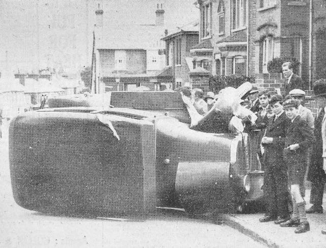
A car on its side in Hatfield Road above the Crown junction in 1929, and attracting much interest.
HERTS ADVERTISER
Oversized trucks, either by height or width, also blocked passage at the former Sutton Road railway bridge.  Many side scrapes have occurred along the narrow section of Hatfield Road between Laurel Road and The Crown, even in recent times.

The reason for widening next to the recreation ground in the 1960s was the number of accidents when visibility was poor around the  bend opposite West & Sellick (now CAMRA) and street lighting was still the pre-war installation.  Thick fogs were also quite common before the Clean Air Acts.  Heavy road rollers and steam carriers were known to be hazardous, especially those hauling trailers, or  those which unexpectedly off-loaded loose barrels, and especially vehicles which were attractive to small children nearby.  Sudden noises might frighten horses pulling carts or wagons and cause them to run away with their tow.

A delivery van made it too literal at the Co-op grocery in Blandford Road in 1933.
HERTS ADVERTISER
Although Camp Road was somewhat quieter, accidents were just as prevalent.  The early road was poor in condition in places, and in at least two places tree banks blocked part of the road near the school and at the former Oakley's dairy farm.

Today's traffic flows may be substantially busier and kerbside parking potentially more dangerous, but perhaps most of us are  better trained for driving and negotiating other road users.  That must count for something.

Saturday, 2 November 2019

Contrasting tracks

Most of our streets came about during the period of expansion and utilisation of former fields into residential or mixed development.  Before Kingshill Avenue there was a field sloping downwards towards the former Marshalswick Farm.  Royston Road and its neighbouring streets were carved out of a large field where cattle had grazed; and Cavendish Road, though there may have been a footpath of sorts, was created from an orchard or a tree nursery or a small crop field, depending on time. 

Although there are minor roads which were formerly footpaths crossing the countryside, and roads linking towns which have existed for several centuries, it is rare to come across a road with a life stretching back into antiquity, probably part of an ancient network of trackways which traversed the region.


Pre-development Beaumont Avenue at the Hatfield Road end.
COURTESY ANDY LAWRENCE
Part of one such route is now Beaumont Avenue and forms an attractive residential road linking Sandpit Lane and Hatfield Road.  Along this road was a minor spur leading to Beaumonts Farm.  The spur today is part private (Farm Road) and part adopted, absorbed by the residential estate as Central Drive.

Remove the homes which line each side of the Avenue, all but three of which arrived since 1899, and you are left with the remains of a double stand of fine trees.  


The track which wandered through the former manor estate had extended through wooded land of uncertain age north of Sandpit Lane.  Today we know this as The Wick.  Also part of Beaumonts Farm was a continuation of the track towards Hill End.  Now Ashey Road, it is a mix of early 1930s semi-detached homes, a post-war industrial estate and the green acres which are now Highfield Park, formerly Hill End Hospital.  How this section of the track contrasted with the Avenue: it had been dug for the clay and was home to a brickworks as a result; and with the exception of isolated groups of trees did not appear to have been treelined.

One further difference: the southern section, though a track snaking through the farm, was a permissive route for traffic other than that which was farm business.  The Avenue, on the other hand, had always been considered private (whether legally so is another matter) and gates were installed at both the Sandpit Lane and Hatfield Road ends.


The former BT building next to the railway, now Alban Away,  Today
part of an industrial estate and earlier a brick works and rubbish tip.

Today's Alban Way still intersects Ashley Road and demonstrates a further difference between the two sections.  But before feeling too satisfied that the avenue escaped the smoke and steam of railway tracks, it was a close call.  The Midland Railway's early iteration proposed a route which would have clipped the northern end of Beaumont Avenue and crossed in front of the former Marshalswick House.  Although Thomas Kinder, owner of Beaumonts, had not been found to have objected to the compulsory purchase of a small portion of his land, the Marten family certainly did, and as a result Beaumont Avenue retained its rural and ancient landscape.  No railway crossing the Avenue.  Same track, but quite a contrast.