Showing posts with label Oakwood School. Show all posts

Wednesday, 12 July 2023

After 78 years


The Beaumonts estate as first laid out. Much of Beaumonts Wood has gone to provide ground for the schools and their playing fields. The broken orange lines never saw the light of day – a short stub of the extended Central Drive is now Oakwood School's entrance drive.


This map was surveyed in 1939.  The Central Drive/Oakwood Drive corner
is on the far right.  It would have been a cross-roads.  A swathe of wooded
ground has already been carved out to make the extension of Oakwood
Drive towards Sandpit Lane, which never happened. There are
other roads with no homes yet behind them. They would appear after WW2.

The final tranche of land belonging to Beaumonts Farm was offered for sale in 1929 and was acquired by holding company Watford Land. The company set out the road plan which would connect with Sandpit Lane, Beaumont Avenue and Hatfield Road, and at subsequent auctions plots were purchased by a number of mainly local house-building companies.  Two spine roads, Beechwood Avenue and Oakwood Drive, were to connect Hatfield Road with Sandpit Lane.  A third one had already existed, and had done so for centuries, Beaumont Avenue.  Beechwood Avenue had been aligned  with the agreement of the council, to connect with Marshalswick Lane as part of what was then known as the Circle Road (ring road).

Three connecting roads also appeared on the development map: Elm Drive, Central Drive and Chestnut Drive. None was completed to their finished lengths.  For the next ten years house building continued, working from Hatfield Road and the southern end of the estate, until in 1940 everything halted because of the war. Most of Beechwood and Elm had been completed. So too had the southern end of Woodland.  Hazelwood south was largely finished on one side and Oakwood had almost reached the future Central Drive.

Oakwood Drive looking towards the corner with Central Drive and in the direction of Sandpit Lane (not, of course, visible).  The (cream) house straight ahead would make such an extension impossible
today.

But restarting such a development after hostilities had finished would financially and logistically be a challenge; many pre-war housebuilding firms did not survive the interregnum, and the post-war license system limited how much building each could carry out.  In part the council came to the rescue by purchasing the swathe of ground from Woodland Drive to the school playing fields boundary.  A revised road layout was devised which took the boundary up to the playing field fence, which would then prevent Oakland Drive from continuing from the Central Drive junction as far as Sandpit Lane. Which later enabled number 51 Central Drive to be constructed in the space of the redundant road line.

The council then built a number of houses for rental in Woodland Drive and Hazelwood Drive north.

Of course, since our home area was effectively a huge building site children of the 1940s and 50s were able to take the short route from Oakwood Drive to Sandpit Lane by walking along the western side of the chain link fence erected by the County Education Department; and once the Hazelwood houses were in build it was easy enough to hop over the fence and follow the same line along the inside edge of the school field.  You could wonder how the author knows that odd fact if you like!  You could even wonder how much is known about the oak tree part way along that walked path close to where the Verulam School's pavilion is located.

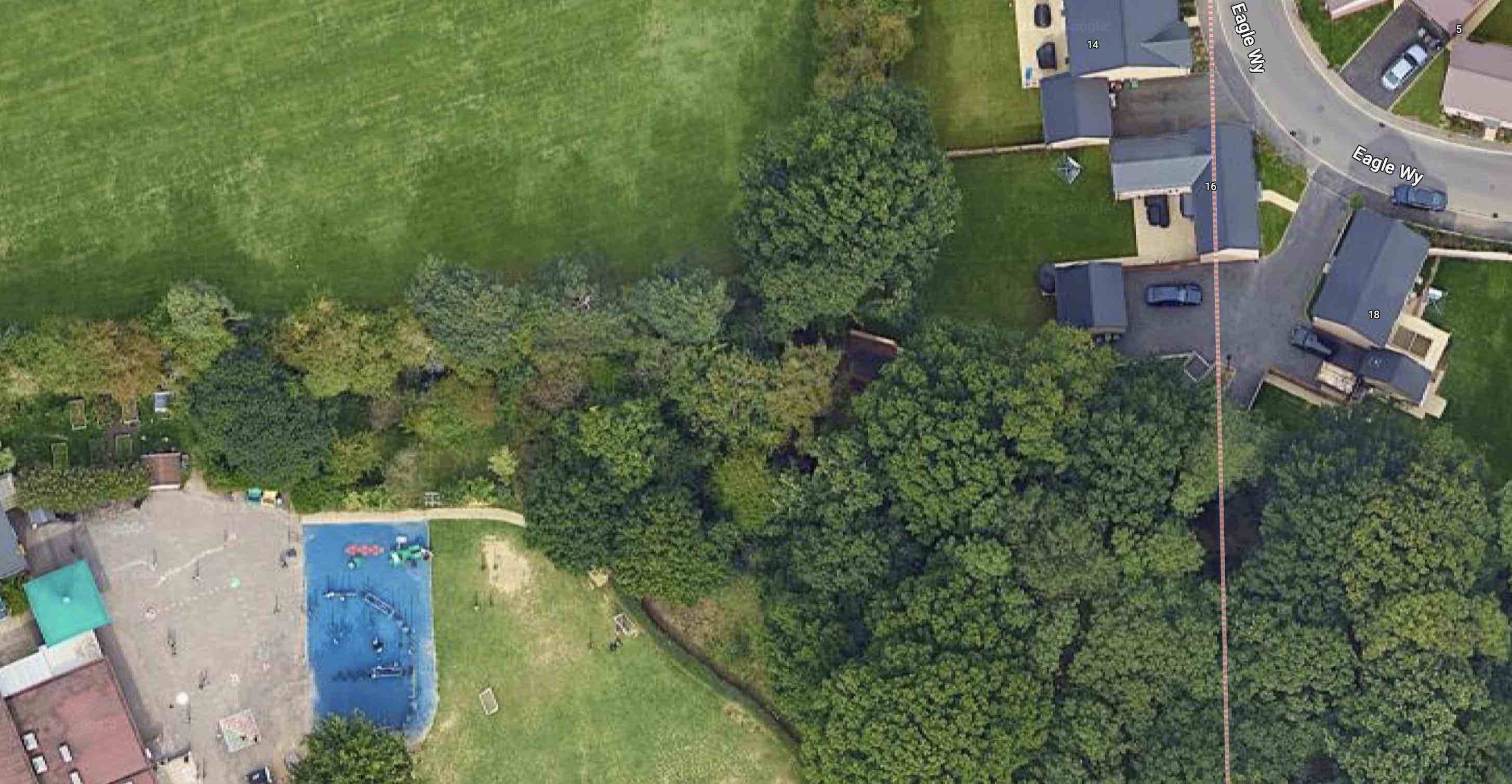
Blue circle: Oakwood/Central corner. Red circle: approximate location of oak tree near Verulam School changing rooms. Yellow circle: beginning of path along Eagle Way. Green broken line: intended path
from Eagle Way to Central Drive. Green dotted lines: informal pathways worn by children in the 1950s.

Almost as soon as we had climbed over that fence we were able to nip across the field to Oaklands Wood, still there behind Oakwood School's site but now much depleted.  The woodland wasn't in any sense public; we knew that because there was a large sign fixed to a tree which informed us to KEEP OUT.  But we ventured there anyway.

I have reached this far in the post to reach the connection between the 1950s and a decision made recently...

Standing out against the sky at Oaklands Grange.

... in the 21st century and at the new housing on the edge of  land belonging to Oaklands, called Oaklands Grange.  Now that the homes are largely all out of the ground an increasing number of people have become familiar with Oaklands Grange and its access to Sandpit Lane not far from the opposite driveway from Newgates, a former mini farm, and the access drive from the Verulam School field.

To leave the Oaklands Grange development residents must walk first to Sandpit Lane – ah ha, so quite close to the old informal route youngsters walked in the 1940s and 50s; seventy-eight years or so after a certain number of those young children found their own way between Sandpit Lane and Central Drive.  If they weren't going to build the extension road, we'll find our own way.  So, an informal path was gradually worn in.   

The future path begins.

The path from Eagle Way skirts outside the boundary of Oakwood School towards
Central Drive.

Children living today at Oaklands Grange are to be given an alternative to the walk along Sandpit Lane, Beechwood Avenue and Central Drive to reach their schools.  They will be able to take a short cut.  The formal start of the path is already prepared at the southern end of Eagle Way.  Pass a few trees westwards and you will reach the former KEEP OUT sign and pass to the outside of the Oakwood School boundary, now itself wooded to reach the school entrance at Central Drive.

Two informal footpaths worn by 1950s children not trying very hard to keep out of trouble, now become part of the 2020s story of families finding their way between home and school along almost the same footpath.  There is little doubt that the child evacuees who came to be part of Beaumont Schools during the 1940s also adventured along these two routes to reach Sandpit Lane and to explore Oaklands Wood and its KEEP OUT sign.

We will look out for the official opening of the new link path, hopefully soon. 


Monday, 23 April 2018

Educating the Newcomers

Work is now well advanced on recreating and improving the website St Albans' Own East End; delivering it on a new, more modern, platform.  There are many limitations to the present website platform, the most important that it is no longer being serviced.  So, as they say, the time has come ...  and we will hopefully see the new site in all its east end splendour later in the summer.

One small new feature on the collection of photo pages devoted to the schools will be a brief history of each one.  We take them for granted, but they came into existence for many different reasons.  Yes, each one opened to provide more places for children living in the district, but the more we explore how their beginnings the more we understand how flimsy was the planning in each case, and how little the various education authorities took account of the data which was available to them.

Today, of course, there is so much data available – and even more can be commissioned by virtually anyone and for any purpose. Even basic facts and numbers available to authorities in the late 19th and early 20th centuries, such as census returns and movement of households into districts, did not appear to convince planners that crunching this limited information could possibly assist in making provision for school places.

For example,  from the 1890s almost thousands of homes were emerging from the fields on both sides of Hatfield Road and for a decade the education authority chose not to commit itself to building a school in the district; not even to negotiate with the developers to reserve a plot of land on which a future school might be built.

Shortly before the emergence of county authorities the St Albans Rural Education Board constructed a school, Camp, specifically for children living in the villages and hamlets on the east side of the city.  This  became urgent because the St Albans (city) Education Board had reviewed its existing policy and denied future access by rural children to city schools, mainly Alma Road, St Peter's and Priory Park, and Hatfield Road.  

Children in all of the homes in the Cavendish, Fleetville and Castle areas were expected to attend Camp School.  It wasn't only a question of numbers either.  A child living in Brampton Road had no straight-line access to Camp School as the only rights of way across the railway line were in Sutton Road and Camp Road.

The first part of Fleetville School opened in 1908, although strangely, the authority had no expectation that many children would attend on the first day, only employing the head teacher and deputy until proof could be shown!  Between them, Camp and Fleetville carried the burden of education the east end's children – all of them up to leaving age – until the opening of Ss Alban & Stephen in 1934.  The removal of senior children into senior schools at Hatfield Road, Priory Park and, eventually Beaumont, occurred from 1930, and relieved some pressure on space. Incredibly, it was not until 1955 and 1958 respectively that new schools were opened at Windermere and Oakwood, the latter being known at the planning stage as the Fleetville Extension School.

We now have nine (10 if Samuel Ryder is included) centres educating primary-aged children, and during the post-war period the education authority was finally able to do what the 1944 Education Act envisioned: to enable primary children to attend a local school within a short walking distance of their homes.  Of course, the open enrolment concept of recent years has partly negated that aspiration, with many children being ferried by car to a school further away on the basis that it is a good school.  Yes, there's a debate to be had here.  Good schools everywhere, more open air and exercise for all, fewer cars, less stress around the school gates, cleaner air ...

Next time we will discover how bad it became for children over the age of eleven.