 |
| Turnpike mile marker at Fleetville Recreation Ground. |
Of course, the post, when first installed, was at the roadside in front of a field in the countryside – Fleetville was still to be invented! When Bycullah Terrace was built c1900 the property doorways were arranged around the location of the post, although it can't be ruled out that the post was moved along the road by a yard or two!
 |
| Numbers 207 and 209 Hatfield Road |
 |
| Bastin's plan showing the mile marker position. |
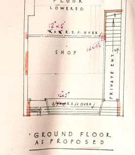
William Bastin was a Fleetville-based builder and had his yard, now occupied by Chapman's Auto Centre, just east of the Rats' Castle. Albert Smith acquired Dr Smythe's premises at 209, with the intention of opening it as a bakery. He therefore engaged William Bastin to draw up plans, which he did before realising there was an obstruction: the Turnpike milepost! We know this because the post was drawn onto the plan by hand afterwards.
 |
| Proposed new shop front showing where the milestone would obstruct the shop door. |
This is therefore the first visual proof of its exact location. While it was satisfactory for the building before modification – it stood in front of a piece of blank wall – the planned shop required the entrance to the shop to be located on the left, while the existing door on the right would give access to the first floor flat. It seems that some negotiation must have taken place with St Albans Council, which then agreed for its removal and storage. It is thought that the post re-appeared when Hatfield Road was widened slightly at the recreation ground.
The answer to the question, where was the post in Bycullah Terrace? Between numbers 207 and 209.
The answer to the question, when was the post moved? The plan is dated 1933 and Mr Smith was trading by 1934.

No comments:
Post a Comment