Showing posts with label North Orbital. Show all posts

Wednesday, 6 October 2021

On the List at Sleapshyde

 Local planning authorities identify particular localities within their boundaries which merit special preservation and conservation.  They  can be designated Conservation Areas (CA). There eighteen such CAs in the city, mainly in the outskirts, and only two of of them, Sleapshyde and Cunningham, are in our East End.  A further 27 CAs have been identified within the city's urban area, of which just two fall within the east end, Granville & Stanhope roads and Clarence Park.

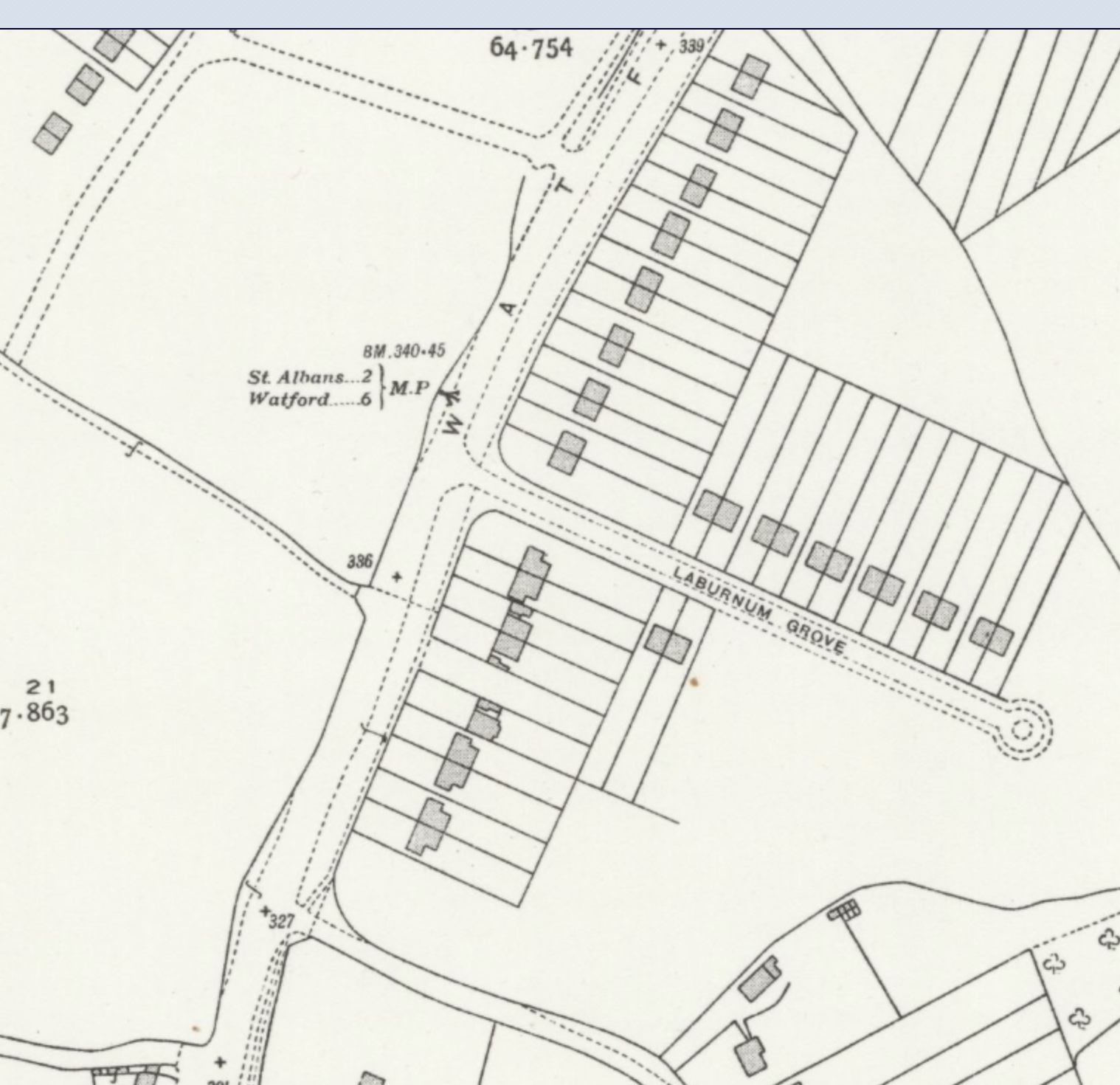
The North Orbital St Albans ByPass is in orange; Smallford Lane runs N-S on the left. Old 
Sleapshyde with three lanes meeting at the tiny triangle is top right. The 1930s estate is the large
tranche of land coloured grey in the centre.
©Open StreetMap contributors

Although brief mention has previously been made of the Granville Conservation Areas in these blogs, I think it is about time further exploration of the character of each of the east end CAs is recorded.  This week I'll begin with Sleapshyde, a compact hamlet sitting between the St Albans Bypass and Sleapshyde Lane, the former joining the latter at the eastern end of the Colney Heath "longabout".  Today, only one third of the built area consists of the historic domestic and agricultural buildings.  

Old Sleapshyde within which are located a few Listed and other significant buildings; a portion of the
1897 OS map around 25 years before the ByPass was constructed.
Courtesy National Library of Scotland

In 1935 builder E Stevens, who specialised in homes for rent, applied for consent to erect 54 homes near the boundary of the then new  Orbital Road (Bypass), but St Albans, the Planning Authority, refused.  The rural council, however, favoured the development to counter the severe shortage of rural housing, and presumably got its way, as there are considerably more than 54 dwellings along Sleapcross Gardens and Sleapshyde Lane today.  None of the hamlet's listed and locally significant buildings sit along these two roads, but lie along the three lanes beyond which converge on a small triangle of land on which there still stands a former public water pump and a former lamp post on top of which is the sign for Sleapshyde.

A heritage picture of The Plough PH when under the ownership of Pryor, Reid & Co, Hatfield.
Modest changes have been made since but the building remains undeniably recognisable.
Courtesy Brian Anderson Collection.

The Character Statement for the CA identifies 8 buildings extending back to between the 16th to 18th centuries, and unsurprisingly most of the Listed buildings fall into this group. First in this discourse and at the end of the northern arm of Sleapshyde Lane is the Plough PH, which should not be confused with the Plough at nearby Tyttenhanger Green.  It contains a popular restaurant. Still with its thatched roof and dormers the 17th century building still backs onto open land.  An annotated wedding photo taken outside in 1913 identifies a former link with another watering hole in the hamlet: one of the party was the licensee of the former Angel PH (see below).

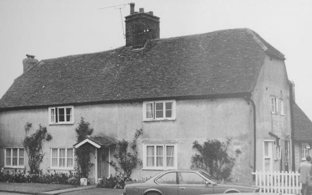
A heritage photo of Sleapshyde Farm, recognisable by its hipped roof.
Courtesy Brian Anderson Collection.

On the section of the lane which returns directly to the Bypass is Sleapshyde Farm.  Unfortunately much of the homestead is hidden behind high fencing with boundary trees and shrubs, but sufficient of its roof is visible to identify its hipped roof.  The CA states its age to be sixteenth century although identifies it to have been a hall style of construction, which suggests it might have been a re-build without changing its design, therefore making the foundations considerably earlier (this has not, however, been verified).  Visitors will identify the extensive dark weatherboarded barns and other outbuildings.

The nearby Farm Cottage is obscured from the lane, but the CA indicates it to be rebuilt in the 19th century around a seventeenth century framework.

The Rose Cottage and Little Rose Cottage on the opposite side of the lane to Sleapshyde Farm.
Courtesy Google Streetview

Along the same arm of the lane but on the other side is a pair of cottages, Rose Cottage and Little Rose Cottage. Both are part of a single structure – you could call them semi-detached.  Most is black weatherboarding with end walls in red brick; the bold chimney stack placed off centre suggests the two cottages are of unequal sizes.  One of the cottages shows evidence of having been extended.

Ye Olde House, which are three separate properties combined.  Set well back from the lane
for improved visibility.

Ye Olde House, at its closest to the modern section of Sleapcross Lane,  is a large and fine building set back from the lane; multi-gabled roof, black first floor weatherboarding with brick ground floor walls.  What might seem like former stables dating from the time of the main house is, according to the CA a modern construction intended for car storage.  Although the name is singular, internally it is divided into three properties.

The former Wesleyan Methodist Chapel with cream surface over the earlier pebble dashing. 
Recent hedge trimming reveals the earlier entry drive and the posting box set into the
brick pillar.

Two un-Listed properties also considered of local interest are Angel Cottage and the former Wesleyan Methodist Chapel.  The chapel is almost opposite the Plough PH.  Until a few years ago the exterior was clad in a soft brown pebbledash, but has recently been rendered in cream.  The rear taller part of the building is on two levels, and its earlier light blue door, bargeboards and drainage pipes are now darker in colour.  It is said that the chapel is one of the earliest in Hertfordshire and was large enough to accommodate the whole population of the hamlet until St Mark's Parish Church was built in 1945.

Now Angel Cottage it was formerly the Angel PH.

At the entrance to the original hamlet in Sleapshyde Lane was a Victorian beer house called the Angel public house.  Although long since closed it was converted for private accommodation, and remains the youngest structure included in the buildings of note in Sleapshyde.

A wander around this pleasant settlement, perhaps following a lunchtime meal or drink at the Plough, will be worth the short time it takes.  Unlike the formal layout of the twentieth century homes along Sleapcross Gardens and Sleapshyde Lane, the scatter of buildings laid out informally at the older end is a pleasant contrast.

The red buildings are listed; the two green buildings are significantly important in the
local context.
Courtesy St Albans District Council


Monday, 10 May 2021

More Turnpike Evidence

 The former Reading & Hatfield Turnpike road in the 18th and 19th centuries divided the north and south sides of Ellenbrook, Oaklands and Fleetville before the tolls were removed and the road was maintained at public expense by the Country authority.  Today we call it Hatfield Road which continues on its way through St Albans, St Stephen's Hill and Watford Road to Watford and Reading.

The mile marker along Hatfield Road outside Popefield Farm, near Smallford.

There is plenty we don't know about the turnpike's workings and toll collecting, but most of us are familiar with the Listed mile markers, still in position along the north side of the road.  If you wish to know more about the road in its toll days visit: 

http://www.stalbansowneastend.org.uk/topic-selection/turnpike-road/

The mile markers shown on that webpage are the only ones remaining; most of those following St Stephen's Hill through to Rickmansworth are missing, although they are referred to on the 1937 survey of the Ordnance Survey maps, and it is therefore assumed they remained by the roadside at least until then.  Many people are also aware that road signs were removed as a defensive measure at the beginning of WW2.  However, since no-one seems to recall those east of St Albans being removed and then returned, can the local authority be relied on to have treated those south of the city in the same way, even if it was the same authority?  Clearly not, since they are still not in place.

It has been suggested that the easiest method of managing such heavy metal objects when trying to remove them was to dig a hole beside each one, tip it in and cover it – job done!  But was that the full story and are the posts still there, below the ground nearby?

The focus of this post is the former mile post close to the Noke Hotel.

This section of the 1937 OS map shows the St Albans bypass (North Orbital Road) joining the Watford Road from the top right, at the location everyone knows as The Noke. The red circle identifies the position of the turnpike mile post to the left of the first and only carriageway when the new road was first built.  Lye Lane is the minor road crossing the bypass from the lower right.
COURTESY NATIONAL LIBRARY OF SCOTLAND

Quite by chance recently the Editor was following proposals during the 1930s for Hertfordshire County Council to close small rural schools and move any residual pupils into nearby town schools.  One such building was the school room in Watford Road which languished with 30 children by the time it closed in the 1930s, which is strange on two counts.  First, the Burston estate was being broken up and developed for housing, becoming the formative Chiswell Green.  The council, meanwhile pressed on with a new JMI school at Mount Pleasant, Bricket Wood; quite a distance for walking children from new St Stephen's and Chiswell Green homes.

The second consideration the council did not take into account was the completion of the St Albans By-Pass, linking up with Watford Road as far as the A41.  When first built it was a fast traffic single carriageway, but children from Chiswell Green and St Stephen's would have needed to cross this bypass to reach their new Mount Pleasant, for which the council provided a crossing patrol four times a day to supervise up to one hundred children across the bypass.

The lunchtime crossing patrol from the Lye Lane side. Between the second and third child from
the right can be spotted the light coloured turnpike mile post along the far fence line.
COURTESY HERTS ADVERTISER

Even today the road infrastructure has a dropped kerb and a fenced-off central reservation to enable
pedestrians to cross both carriageways.  This is where the children crossed in 1939.
COURTESY GOOGLE STREETVIEW

For our evidence it was fortunate the council elected to make the crossing point opposite Lye Lane; and it was also fortunate the Herts Advertiser considered the decision worthy of sending a staff photographer to the site.  The picture was taken as the children returned home at lunchtime and was standing where the bus layby is today.  It was taken at the beginning of June 1939.  What a responsibility for Mr H J Cornwall, the crossing man holding the board announcing "STOP. Crossing Patrol".

Now, just look between the second and third children from the right.  Along the fence line, and sitting just where the map says it should, is the turnpike mile marker, 3 miles from St Albans and 5 from Watford.  The Herts Advertiser has proved it.

An altogether more complex junction today for even faster traffic, buses, crossing
pedestrians (probably after leaving or boarding a bus) and vehicles leaving/joining one of
the side roads. The newer carriageway is on the left.
COURTESY GOOGLE EARTH

However, there is no point using a metal detector at the site today in the hope of locating the buried object.  Several improvements have been made to the bypass since then, including a second carriageway on that side of the road.  It may now be under the newer tarmac, or may have been removed from the site along with countless tons of rubble and subsoil in the construction of the dualled road.

But at least we still have photographed evidence it was present at the correct spot along the road in June 1939 and that several times a day it was passed by dozens of children on their way to and from Mount Pleasant School.

The location of the next turnpike mile marker was here (MP), along Watford Road, opposite its
junction with Laburnum Grove, just where the main road was a little wider.  Before
World War Two houses had not been built on the west side of Watford Road.
COURTESY NATIONAL LIBRARY OF SCOTLAND

The Watford Road/Laburnum Road junction today.  Do you think anyone took a photograph here
sometime before 1939?
COURTESY GOOGLE EARTH

And if anyone has a collection of photos pictures taken along Watford Road in Chiswell Green and taken in the 1930s, evidence of the next marker would be useful.  It stood opposite the end of Laburnam Grove, where Watford Road was always a little wider and where there is now a service road.  Before the war no new homes had been built opposite Laburnum Grove so the view would have been of open fields.

The account this week may not be be about the East End, but it is the same road which connects the two.  Let's try and solve the puzzle of  another turnpike mile marker.

Friday, 28 June 2019

Avoiding Hatfield Road

At times it can seem like a conundrum with no easy solution, but the question of avoiding driving along Hatfield Road, can be countered by the equally exasperating how to avoid Sandpit Lane, and even how to avoid the bypass.

When traffic flows smoothly on all three roads between Hatfield and St Albans there is no issue, and at least on two of the roads the resulting extended travelling times are, hopefully, temporary.

In Hatfield Road, readers may recall, a few months ago gas pipe replacement work was undertaken in St Albans Road West, between Smallford and Ellenbrook.  For the next two months similar work is to start between Smallford and Oaklands with the inevitable one-way working using temporary traffic signals.  This is a busy section at the best of times and two new permanent signal sets have been installed at Oaklands College (pedestrian controlled) and at Kingsbury Gardens.  The former is near the uncontrolled  junctions of  Colney Heath Lane and South Drive, but so far the interruption to flow has been minimal.  But in a foretaste of what is to come temporary signals in three phases arrived recently near Oakwood Drive and Longacres.  Standing traffic queued back as far as Smallford roundabout.

Junction improvements in Sandpit Lane.
So, if that is not to your liking you could try driving westwards via Sandpit Lane, but you are likely to be queuing soon after the House Lane roundabout.  The reason here is road surfacing, new junction, footpaths and roundabout at Oaklands Grange, near Barnfield Road.  Work has been ongoing for several months, and the recent difficulties have probably resulted from some drivers trying to avoid the Hatfield Road works – which are about to get even worse.

Of course, once clear of Newgates the next queue is at the Beechwood Avenue lights, where there seem to be more vehicles than usual turning left to return to Hatfield or Ashley roads, but no doubt a proportion of drivers continue west to find alternative routes nearer the city.  And I have noticed a small increase in cars and vans turning north into House Lane, no doubt heading for Marshalswick and the fiveways junction at the King William IV.

So, let's try the bypass.  You might join it at the Roe Green interchange and westwards you may have a fairly easy journey as far as London Colney's congested roundabout – though continuing further west to avoid the city you could join a long queue on the approach to Park Street.  

Normally, travelling eastwards takes time on approaching Roe Green, although we might be applying the brakes anywhere back to Sleapshyde Lane, but once this junction has been negotiated, on the green as it were, you are buoyed at the prospect of a swift journey through the tunnel, except that recently eastbound traffic has sometimes been stationary underneath the Galleria and very slow moving as it leaves the A1(M) on the approach to the former Jack Olding's junction.

I can find no obvious cause except for the usual "weight of traffic", but travelling between Hatfield and St Albans is presently fraught with problems and therefore expensive on fuel and time.  Best to leave a generous amount of time for your journey and stock up with some extra patience!

Sunday, 6 January 2019

A Way Through

Most of us have come to terms with – or not as the case may be – St Albans being a nightmare to drive in or through.  But for us on the eastern side there was, in the early days of motoring, an indirect benefit brought to us courtesy of the government's post-WW1 roads programme.  The St Albans Bypass, which was also in part a Fleetville Bypass, was a present to the district in the 1920s.  So, we might ponder where we might be today without it.  Would Hatfield Road instead be a dualled carriageway?  Possibly, or maybe not.

In 1965 the County Council's St Albans Transportation Study (SATS) was published, the result of detailed analysis of traffic movements, congestion and other factors, such as parking, which acted as influences on everyone's journeys by road at the time.

The City Council had spent the best part of thirty years developing the ring road, finally completed the project just as the SATS was published.  As we realised fairly quickly the early parts of the road were developed, not as a single infrastructure project, but in conjunction with housing developers; the result being that the ring road was just another residential road, and as direction signs moved traffic on to it and away from the city centre, there were many objections from residents' groups, mainly because of the heavy vehicles using it.  Eventually the signs disappeared, and so did the ring road name.

Two new traffic schemes were discussed in the SATS.  One will form the subject of the next post; the other became possible because British Rail offered for sale the branch railway land it owned, now Alban Way.

Looking towards the former Northwestern Hotel, Holywell Hill.
SATS therefore proposed – another – Fleetville Bypass using railway land between London Road and Colney Heath Lane, although the maps produced showed an extension to link with the then newly dualled carriageway at the former Northwestern Hotel, Holywell Hill (or is it St Stephen's Hill at that point?).  

The link with London Road is shown as a curved road which was "thoughtfully" constructed as the later Orient Way.  A roundabout was proposed at Ashley Road, although the difference in elevation would have required some infrastructure works at a location which had only just received a new bridge.  Presumably, the connection at Hatfield Road/Colney Heath Road would have similarly been in the form of a roundabout – how today's drivers would welcome a roundabout here.
This road leaves London Road and connects with Alban Way at the former
London Road Station.

The press made the assumption that the new road would be a dualled carriageway, presumably because that is what most bypasses were.  However, SATS states that the road would be a two lane single carriageway; just as well, as the railway land would not allow for a wider road.  While raising this option as a viable option, the report also recognised a serious concern that air quality and traffic noise would be brought close to people's homes over the majority of the new road's length, and that would count against that option in any decisions the county council would have to make.

Colney Heath Lane/Hatfield Road junction.  Considering the subject
matter, in these three photos there is barely a vehicle to be seen!

Since the railway route did not materialise – nor any other option put forward – we are left to speculate on the benefits it might have had.  What difference would it have actually made to Hatfield Road?  Would it have made any difference to driving (or riding on a bus for that matter) into and through the centre of the city?

So, from the point of view of the railway route, fifty-five years on and we are still using the same road network, and goodness knows how many road possibilities have been drawn on council maps since.  Meanwhile, the original bypass (North Orbital) has since been dualled – it was initially laid as a single carriageway – and still has the land for widening to three lanes each way.  Its actual capacity is limited by its surface roundabouts, and still lacks the overbridge at the Smallford Lane/Colney Heath intersection.  But that's another story.