
The former Reading & Hatfield Turnpike road in the 18th and 19th centuries divided the north and south sides of Ellenbrook, Oaklands and Fleetville before the tolls were removed and the road was maintained at public expense by the Country authority. Today we call it Hatfield Road which continues on its way through St Albans, St Stephen's Hill and Watford Road to Watford and Reading.
 |
| The mile marker along Hatfield Road outside Popefield Farm, near Smallford. |
There is plenty we don't know about the turnpike's workings and toll collecting, but most of us are familiar with the Listed mile markers, still in position along the north side of the road. If you wish to know more about the road in its toll days visit:
http://www.stalbansowneastend.org.uk/topic-selection/turnpike-road/
The mile markers shown on that webpage are the only ones remaining; most of those following St Stephen's Hill through to Rickmansworth are missing, although they are referred to on the 1937 survey of the Ordnance Survey maps, and it is therefore assumed they remained by the roadside at least until then. Many people are also aware that road signs were removed as a defensive measure at the beginning of WW2. However, since no-one seems to recall those east of St Albans being removed and then returned, can the local authority be relied on to have treated those south of the city in the same way, even if it was the same authority? Clearly not, since they are still not in place.
It has been suggested that the easiest method of managing such heavy metal objects when trying to remove them was to dig a hole beside each one, tip it in and cover it – job done! But was that the full story and are the posts still there, below the ground nearby?
The focus of this post is the former mile post close to the Noke Hotel.
 |
| This section of the 1937 OS map shows the St Albans bypass (North Orbital Road) joining the Watford Road from the top right, at the location everyone knows as The Noke. The red circle identifies the position of the turnpike mile post to the left of the first and only carriageway when the new road was first built. Lye Lane is the minor road crossing the bypass from the lower right. COURTESY NATIONAL LIBRARY OF SCOTLAND |
The second consideration the council did not take into account was the completion of the St Albans By-Pass, linking up with Watford Road as far as the A41. When first built it was a fast traffic single carriageway, but children from Chiswell Green and St Stephen's would have needed to cross this bypass to reach their new Mount Pleasant, for which the council provided a crossing patrol four times a day to supervise up to one hundred children across the bypass.
 |
| The lunchtime crossing patrol from the Lye Lane side. Between the second and third child from the right can be spotted the light coloured turnpike mile post along the far fence line. COURTESY HERTS ADVERTISER |
 |
| Even today the road infrastructure has a dropped kerb and a fenced-off central reservation to enable pedestrians to cross both carriageways. This is where the children crossed in 1939. COURTESY GOOGLE STREETVIEW |
Now, just look between the second and third children from the right. Along the fence line, and sitting just where the map says it should, is the turnpike mile marker, 3 miles from St Albans and 5 from Watford. The Herts Advertiser has proved it.
 |
| An altogether more complex junction today for even faster traffic, buses, crossing pedestrians (probably after leaving or boarding a bus) and vehicles leaving/joining one of the side roads. The newer carriageway is on the left. COURTESY GOOGLE EARTH |
But at least we still have photographed evidence it was present at the correct spot along the road in June 1939 and that several times a day it was passed by dozens of children on their way to and from Mount Pleasant School.
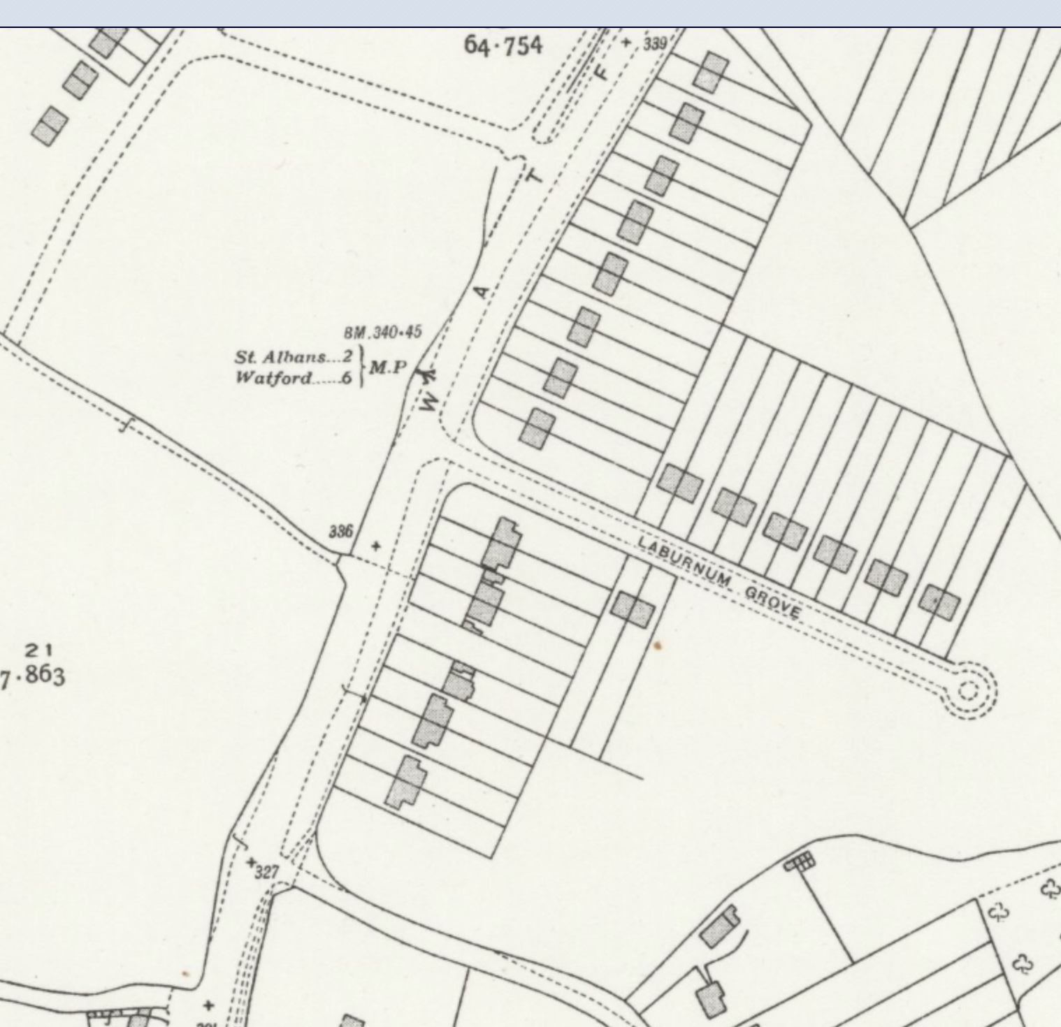 |
| The location of the next turnpike mile marker was here (MP), along Watford Road, opposite its junction with Laburnum Grove, just where the main road was a little wider. Before World War Two houses had not been built on the west side of Watford Road. COURTESY NATIONAL LIBRARY OF SCOTLAND |
 |
| The Watford Road/Laburnum Road junction today. Do you think anyone took a photograph here sometime before 1939? COURTESY GOOGLE EARTH |
The account this week may not be be about the East End, but it is the same road which connects the two. Let's try and solve the puzzle of another turnpike mile marker.
No comments:
Post a Comment