St Albans has been given a policing power as a borough and later city. Most of the rest of the county was governed by the County Constabulary. Before 1948 both forces were represented with buildings in Chequer Street and Victoria Street. But this post is not about the history of these two bodies. It is about what happened as a result of the expansion of St Albans.
 |
| The building on the right, at the top of Victoria Street, was the St Albans City Police Station, replaced in the 1960s by the new station recently demolished. COURTESY ANDY LAWRENCE |
Until 1913 the County Police found itself responsible for an increasing area east of The Crown as Camp and Fleetville districts spread, and some more rural communities expanded. So a new St Albans Rural HQ was set up in Tess Road, now Woodstock Road South, where the nursery parking area is now situated.
In 1913 the city boundaries were expanded in several directions, most dominantly out towards Oaklands. So the County's net spread wider and the City force took over within the new urban boundaries. Additional officers were therefore employed, but it became increasingly difficult without telephones for beat officers to report into Victoria Street from a wider patch while they were on duty. And no easier for residents and business owners distant from the city centre to make contact with the police.
 |
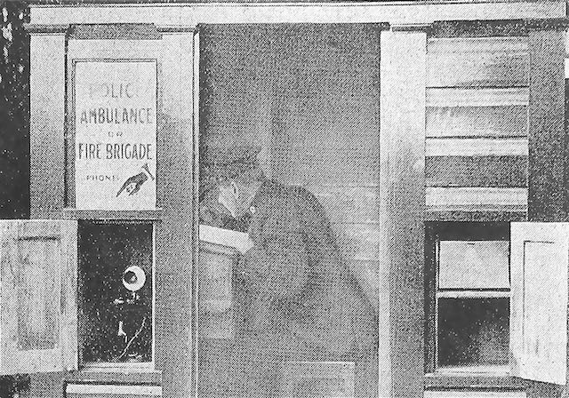
| Police Call Box, location not yet identified, installed in 1932. COURTESY HERTS ADVERTISER |
 |
| Duty policeman seated inside to complete a report. COURTESY HERTS ADVERTISER |
In 1932 a number of portable police boxes or cabins were manufactured and sited in strategic locations. An officer could then complete forms and report by phone directly to the police station, either at the end of his duty, or on other urgent business. When the station needed to contact the cabin a blue flashing light on the roof was lit. If the officer on duty was sighted away from the box it was not unknown for members of the public to alert him "his Sergeant wants him on the phone!" Residents could also use the phone directly to call the police station for the equivalent of a 999 service which had not yet been invented. Although the phone was inside the cabin the listening and speaking parts were accessible from a little door outside.
By 1939 the wooden structures were deteriorating, and in preparation for wartime brick cabins with reinforced flat roofs replaced them. I was always aware of such a brick structure at the junction of Hatfield Road and Beechwood Avenue and had therefore assumed the earlier wooden cabin to have been there as well.
 |
| Brick replacement cabin with reinforced roof from 1939 located at the junction of Hatfield Road and Beechwood Avenue. COURTESY PHILIP ORDE |
Recently I noticed in the background of a 1938 photo taken in Hatfield Road looking towards Ballito Hosiery Mill at Sutton Road corner, what looked very much like a wooden police cabin. It was also marked on an OS map published in 1937 and therefore surveyed earlier.
 |
| Ordnance Survey map published 1937. The circled square in the corner of the Ballito Hosiery Mill cycle yard is the Police Call Box. COURTESY NATIONAL LIBRARY OF SCOTLAND |
However, unlike other wooden cabins this one was not replaced in 1939. So, did Fleetville not have a brick replacement? It seems likely that during the later 1930s, and with the Beaumonts area expanding, the decision was made to shift the position of the brick cabin to Beechwood Avenue.
I realise the quality of the photo was not good, so I was delighted this week to see another Herts Advertiser 1930s photo of flooding near Sutton Road; in the background was a wooden police cabin next to the footpath just inside Sutton Road, with its foundation just outside the end of the mill building where there was a row of cycle racks.
After World War Two the City Force was subsumed into the County Constabulary, and for as long as it was required the Woodstock Road South station continued to be occupied.
As telephone cables had been increasingly laid, lighter and slimmer police pillars appeared on a few street corners.
 |
| One of a range of pillar-type PCBs. This was installed near St Peter's Green, St Peter's Street. No comfort, though, for police officers! COURTESY HERTS ADVERTISER |
But one final thought before the roll-out of relatively portable mobile communications: was there a wooden cabin, or later brick version, sited anywhere on the Camp side of the former railway line? The 1937 map shows there was one at the Sandpit Lane entrance to The Wick. The search continues.


No comments:
Post a Comment