Wednesday, 27 May 2020

Laurel

The ladder roads on the north side of Hatfield Road, those between Harlesden and Blandford, are well-recalled by name, but there one other less well remembered street, although it leads nowhere except the ends of one or two Clarence Road rear gardens.  This is Laurel Road, one of those development roads which was intended to squeeze in a few extra small homes in an awkwardly shaped section of the site close to St Peter's Farm.  Although there is no remaining evidence for the street name, it is possible to search for it.  All we need is to return to the period prior to the development in the late 1890s.


Hatfield Road passes the farm in 1872.  Clarence Road will later be laid just
to the left of the pond; the shrubbery is to the right of the farm buildings.
COURTESY NATIONAL LIBRARY OF SCOTLAND
So clear all homes and shops from your mind – even the 1880s Cavendish estate. Stand, in your imagination, at the top of the hill in Hatfield Road and look down  towards what is now The Crown junction.  Here was yet another broad stream valley with its lowest ground from right to left into Camp Road.  Apart from a tiny turnpike toll building only one pair of buildings would be visible: St Peter's Farm and the adjacent St Peter's Farm Cottage.


Laurel Road c2012.  The houses in the background front onto Clarence Road.
They are still there in the form of the Conservative Club and Clarence Mews, the latter being a gated conversion of former farm outbuildings accessible from Clarence Road, opposite the main park entrance.  The farm buildings are not ancient in the sense of most farm homesteads; it appears that this was a farm holding created in the early 19th century.  But when built the land owner still felt it important to lay the homestead foundations on slightly elevated  ground on the eastern side of the valley referred to above – today we walk this valley side in front of the shops from the Crown corner towards Laurel Road.

With a change of tenancy in 1878 the farm buildings were advertised on the farm estate plan, along with its fields.  When the farm was sold in the late 1890s, there remained two homes available to sell or let which were already there, the farm and farm cottage.  The opportunity was taken to provide a name for this pair, and so they became known as Laurel Bank after the shrubs and trees growing behind the farm, as shown in the 1872 map.  It is from this landscape feature that the little road at the top of the valley side was named.
Estate map St Peter's Farm, 1878.  The owner has named the farm Ardounie
COURTESY HALS

The street directories at the time show that the first occupants were Mr G Mead (farm) and Mr H Pearce (cottage), but they was quickly followed by Edward Hansell, an architect and surveyor.  It is therefore possible that Mr Hansell was involved in the residential developments then being laid out along Hatfield Road.  Once most of the estate had been completed Laurel Bank became available once more and Mr Raymond Nelson, a draper and outfitter, lived and traded from the premises until the Conservative Club acquired the former farm c1946.


Hatfield Road in lower part of view; Clarence Road upper left; former farm and cottage behind the hedge in Hatfield Road.
Former outbuildings converted into a square Mews arrangement.  Laurel Road on right.  Former shrubbery between the
farm and Laurel Road.
COURTESY GOOGLE EARTH


While that may explain the naming of Laurel Road and its connection with the former farm, there is another name which is revealed in the 1878 farm estate map.  For while the Ordnance Survey map from six years earlier labels the buildings as St Peter's Farm, the farm estate map identifies the homestead as Ardounie.  This name is listed in the reference work Fairbairns Crests, although its specific connection with this location is unclear.

Next time we'll explore those homes and shops which filled the space between the newly laid out Clarence Park Road (as originally named) and that little Laurel Road at the top of the hill, passing the old farm on the way.


Monday, 18 May 2020

Useful Retail Trade

Near the junction with Sandfield Road this Hatfield Road premises was built c1905 and occupied by builder and joiner James Andrew.  You may recognise the familiar features of the frontage, which, apart from colours, has changed little.  Today it is part of SK Carpets, and for more than half a century was P H Stone, newsagent. There is no evidence for this but it is likely that Mrs Andrew and daughter looked after the shop and are shown in the photo.


James Andrew's first shop at 157 Hatfield Road.


The same premises (on the right) in 2012.

Mr Andrew, having arrived in Hatfield Road, lost little time in acquiring a plot opposite for use as a yard for his building work.  I can't be certain he may also have built what was originally a semi-detached pair, named Surrey House and Troon House.  They were early enough which, together with the yard, was numbered in the initial Post Office  sequence.  As with most of the early homes along Hatfield Road they remained purely residences for a very short time before the benefits of retail trade became irresistible.  The facts appear to show the closure of the shop on the north side at about the same time as the righthand premises were opened as a shop on the south side.  James Andrew himself may have converted it so that all of his business was on one site.

Although keeping the building yard until about 1930, he gave up the shop around 1925.  Harry Tuckett, whose father had been a manager at Hallam's ironmongery shop on the corner of Chequer Street and High Street, took over the shop.  His older brother Bertie had been running the New Camp General Stores since 1910; this is the shop which itself became an ironmongers under John Dearman, and latterly Dearman-Gomm's, now closed.

Meanwhile Surrey House next door to the Hatfield Road ironmongery was also quickly turned into a shop for drapery; at first by Deekin & Watson.  But as soon as Harry Tuckett secured Mr Andrew's former premises, Harry's sister, Edith ran the drapery business next door.

When Harry died in 1952, Leonard Reed purchased the ironmongery and Gladys Cox turned the drapery into an outfitter's.  In competition with the nearby Handy Stores, Leon Reed not only added timber sales in the former outfitter's shop, but also added  extensions to the left and right to further expand his product ranges. However, the arrival of DIY warehouses made small ironmongery shops untenable and by the 1990s both Reeds, Handy Stores, and another useful shop, Blackstaffe's, had gone.


The original houses, Surrey House and Troon House: the drapery on the left and Tuckett's on the
right.  Mr Reed's two extensions on a day following final closure.
COURTESY DIANA DEVEREUX


Access to Mr Andrew's builder's yard was to the right of the extension.  Behind the red car is the 1960s block Grimsdyke Lodge, built by Grimsdyke Developments Ltd, and formerly a detached house and lock-up garage plot.  COURTESY DIANA DEVEREUX.

While we have the opportunity of investigating the 1990s photo with the red car we can take a peep beyond to the Grimsdyke Lodge flats, a late 1960s development.  At the far end was a 1930s detached house lived in for most of its time by Mrs Bell.  A large area to the right and presumably intended as a garden, was used as a rather untidy group of car lock-up garages.

Scrutiny of the Valuation Office records indicates the owner of the lock-up garages was C H Lavers, 12 Alma Road.  The record is dated 1953, but Lavers may well have acquired the site at the same time as it had purchased its timber yard (now Morrison's petrol station and car park) in c1925.  This date coincides with the withdrawal of James Andrew from trading in Hatfield Road.  Which neatly returns us to our starting point.

Except that we've not discovered what was built more recently.  Well, this: the Richmond House development and its bike shop!


Tuesday, 5 May 2020

Not Easy to Smile

This Friday and Saturday is the 75th Anniversary of VE Day, Victory in Europe, in the closing stages of the Second World War.  8th May for most of us, but we should remember that the communities in the Channel Islands would have to wait a further 24 hours before being freed from enemy control on the 9th; every year since the islands have commemorated Liberation Day.


Preparing for VE Day at Pageant Road
COURTESY ANGELA EMERY
We had all been anticipating this date;  a similar experience every young child has from early December, waiting impatiently for Christmas to arrive.  With many staple foods in short supply householders had been saving a little at a time against the ration, and food and drink which would last for a long time, tins, powders, drink would be brought out in readiness for a celebration on the day. 


VJ Day street party in Elm Drive
COURTESY JENNY BOLTON
Most of the surviving film we will see on television this week  focused on the mass gatherings in city centres, but more people enjoyed themselves in their localities with their families and  children at street parties.  We know of such parties in Burnham Road, Castle Road, Woodland Drive, Cavendish Road and Longacres, but there are also likely to have been others.  Pianos, wireless radios and gramophones to provide music, chairs and tables borrowed from homes, local churches, and schools and other community buildings; food and drink pooled from home kitchens and brought to the centre of the parties in closed roads; and whatever decorations, bunting and messages could be mustered in the hours beforehand.

These were the brief days of huge relief after six years of everyone's world being turned upside down.  Men serving in the forces, many of whom not returning, families sent to where the war-footing work was; families broken with children evacuated – mums too;  shortage of most materials, including food, and therefore ongoing management of ration books and points.  Many contended with other adults or children billeted in our homes; the frequent fear of being bombed and alerted perhaps in the middle of the night by sirens; living a transient life in shelters.


Bomb damage Selwyn Estate 1944
COURTESY HERTS ADVERTISER
On VE Day the over-riding feeling was relief, all of that was now in the past.  It was over.  Except that it wasn't.  Life wasn't going to return to the peaceful and normal pre-war days.  Rationing would continue until 1954; troops would only return gradually, battles had still to be fought,  the economy was bankrupt, we were persuaded to save everything we could.  Bombed out towns and cities had to be re-built, housing was in acutely short supply, and most products from factories were reserved for export.

Yes, over time, our lives did improve and there was a new normal, moulded gradually over a generation.  On May 8th and 9th 1945 we could relax and look forward, although tens of thousands of families would be commemorating a loved one lost, perhaps with a candle in the window.  It was a brief interval before preparing ourselves for repairing and moving on.

This is a story for our times too; we are again looking forward to that brief interlude, a candle-lighting moment, before preparing ourselves for repairing and moving on.  May 8th and 9th will have more resonance to us this year than on any previous occasion.

Sunday, 26 April 2020

Middle of the Road

While most people are not leaving home to attend their work places, and the rest of us are venturing beyond the front door only to exercise or buy food, a new adventure, of sorts, has quickly grown, mainly out of necessity: walking in the road space.  Unless an oncoming pedestrian looks ahead and waits at a corner or pauses in an open driveway, we may be forced to take the lead and venture into the nearside road lane.  The opportunities are even there on normally busy roads, and the author has even spent the best part of an hour walking in the road and met no more than five or six cars.

Waiting for the Olympic Torch Relay in 2012; an excited throng along a quiet Hatfield Road.

Co-incidentally, in creating material for a local digital newsletter a month ago I made mention of an advance notice by the BBC that it intends to build a programme of London 2012 Olympic events, including running the full opening ceremony from the Olympic Park.  There is, of course, plenty of room in the schedules since the postponement of the Tokyo Olympics.  In the newsletter I reflected on one part of 2012 which most closely involved the East End of St Albans, which was the Torch Relay.  So we remember that joyous day along Hatfield Road, when, after the road closure and before the torch bearers passed westwards towards the city centre, a number of us walked casually in the middle of Hatfield Road, paused, chatted, even sat down, the latter just because we could!  I mused that such a chance would probably never again be experienced by any of us without putting ourselves in danger.  I wrote it at the time of the event, and I repeated it for the recent newsletter, but as soon as the words were on the page, the reality of a repeat opportunity was suddenly created, even for short bursts of time in Hatfield Road.

A busy Hatfield Road c1910, Fleetville, but not a motor vehicle in sight.

Probably the earliest surviving photograph of Hatfield Road, Fleetville has come to rare notice, partly because of the inferior quality of the image.  In spite of this it tells of a busy period of day outside the printing works, now replaced by Morrison's.  It can be dated to around 1910, as the County Council had carried out paving the length of Hatfield Road in that year.  But the numbers of residents or employees casually walking in the roadway, with no more danger than from passing cyclists, suggests the arrival of a motor vehicle was still a rare event.

The same view over 100 years later, with the print works building replaced by a supermarket.
COURTESY GOOGLE STREETVIEW


Being less confident than the 1910 photographer the author left it to a Google Streetview vehicle driver to capture a recent photograph taken roughly at the roundabout giving access to Royal Road in one direction and the Morrison's car park in the other.  This is where the 1910 photographer would have stood.  Royal Road would be just out of sight to the left of the picture and a gateway leading to spare land owned by Smith's printing works just to the right of the tree at the right edge.  This gateway would later be the entrance to Marconi Instruments Fleetville.  Behind the two hatted ladies closest to the photographer were trees and shrubs on spare land behind the lay-by in the modern picture, and a shop blind reveals the location of Bycullah Terrace.  The only other difference were the tall trunk telephone wire poles which marched their way along Hatfield Road on their way to Hatfield; today the wires are protected in trunking and lie beneath our feet.

It would not be long before the number of vehicles of all kinds grew in number along this road, sufficient to encourage and then force us to walk along the footpaths, but it would be another twenty years from the first photo before such a path was laid on the south side – there were no shops here.


Saturday, 18 April 2020

Wretched Road Charges

The oft-quoted complaint by most householders, whether tenants or owners, at some point after moving into a new house before the 1950s.  Streets were laid out; water and gas mains laid – electricity and drainage only later – and homes constructed. Each owner was deemed to be responsible for the footpath and road for up to half of its width.  No-one was happy about purchasing a corner plot since that meant, when the time came for the rest of the road infrastructure to be laid, surfaced and lit, you paid twice.  Councils, which ended up carrying out these improvement works, would only agree to do so once most of the homes had been finished and occupied; possibly a period of several years or even decades.  The cost was not intended to be a charge on the rates (now replaced by council tax) and each householder received an invoice from the council for the wretched road charges – sometimes referred to at the time as private street works.

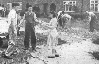
All such streets were considered private, owned jointly by its occupiers or landlords, until such time as the council had sufficient funds to carry out the work with a good chance of being recompensed through special loan schemes; the sums involved were not inconsiderable.  In the meantime, residents put up with the inconvenience of dust, mud and potholes, sometimes for several years.  The photo of a community group from Woodland Drive agreeing to carry out some of the more serious work was not unusual; it was, after all their road.

When residential development took place without regard to overall responsibility for drainage, adding more and more buildings and hard surfaces also added flooding risk.  Between the northern and southern halves of previously Spencer-owned land lies Brampton Road and its downhill gradient from the park end to Woodstock Road.  Before the houses went up surface water in periods of heavy rainfall would have found its way towards the former ancient  stream bed just east of the Woodstock Road homes, eventually finding its way to the Ver, the Colne and the Thames.

Hamilton Road today
COURTESY GOOGLE EARTH
When the water can't soak into the ground or run away safely, it might hang around in puddles and lakes, such as at the southern end of Hamilton Road.  Memories are recalled of women walking to the route 354 bus stop in Brampton Road with a spare pair of wellington boots for husbands returning from the station.  All part of the well-rehearsed wet weather routine.

In fact so long did the Hamilton Road residents have to wait that the earliest had lived there for over twenty-five years; by which time the road had been torn up to lay larger drainage pipes all the way to Campfield Road.  

Since the road was their pride the householders agreed to purchase a few small street trees.  An early attempt to take the same approach to paying for street lights [the editor knows what it was like growing up in a dark estate devoid of lighting] was more difficult to resolve, since the largest cost was in laying the cables, so a start was made from a connection from Jennings and Brampton roads; the long middle section was still dark!

A Sunday morning road mending session; Woodland Drive north in the
early 1950s
COURTESY HERTS ADVERTISER
Experiences of living in dust, mud, floods and darkness are repeatedly told in the St Albans' East End, from Camp and Fleetville, Oaklands, Marshalswick and Beaumonts, and along Hatfield Road too. The adventure living on this side of the city pervaded well into the 1960s.

Today, house builders have to do more than build homes; they must comply with standards set by regulatory bodies and local authorities, and carry out road construction, public lighting, cycle and pedestrian routes, and of course community open space, before the council signs off the development and agrees to adopt the road(s), street plates included.  Aren't we lucky?  Maybe, but that's what we have paid for.  People today moving into Osprey Drive and Austen Way won't be enduring the same fun as those from Royston Road, Meadow Close and Hamilton Road in their time. 

Sunday, 5 April 2020

Bigger and More Proud

Eighteen seventy-seven: it turned out to be a significant year in the history of St Albans, as the Abbey became a Cathedral (formally known as the Cathedral and Abbey Church of St Alban) and a Bishopric.  The Council then successfully applied for the Monarch, Queen Victoria, to confer the status of city on for St Albans.

Co-incidentally (or not) in the same year the rather rural sounding  Sweetbriar Lane was changed to become Victoria Street from the Town Hall to the city boundary, which since 1835, had been set at Lattimore Road from its previous limit near Marlborough Road.  No markers exist to show where these limits were.

1879 boundary post at Bluehouse Hill.
In 1877 the Herts Advertiser published details of the number of residents.  8,303 lived within the borough (the 1835 limits), 11,000 in the wider town – from the Market Cross to one mile distant.  So around 3,000 people resided beyond the city limit although would have relied of the services of the city and its council for various aspects of their lives.  The time had therefore come to apply for the extension of the boundary to approximately three-quarters of a mile.  Eastwards that created a new limit along Hatfield Road at  Albion Road.  This extension was granted in 1879 and for such a historic occasion the new Council had boundary posts manufactured, most of which remain today.  The wording proudly reflects the new status of the borough as a city.  Below the crest are the words CITY OF ST ALBAN 1879.  The town's name used to be written with an apostrophe (St Alban's) but today this is universally omitted.

1913 post in Sandpit Lane:
date label not quite level
Even in 1879 houses were being built beyond the boundary and the council therefore found itself in a similar position in 1913 when an application to take in new added areas as far as Oaklands was successful.  On this occasion new posts were set up with the same wording but with the year 1913 inside a rectangular panel, this panel having been added to the posts after casting, and not always in exactly the same position.  On the Sandpit Lane post it not quite horizontal.

1913 post at Hill End Lane

A much smaller boundary extension took place in 1935 but no dated boundary posts were produced.

The responsibility for looking after the markers rests with the local authority, but inevitably they end up being treated like lamp posts, road signs and other items of street furniture in being neglected.  The boundary posts are also prone to being hidden in undergrowth and shrubs, including ivy.  If the city was proud of them and their function when first installed, perhaps we should all feel a little bit proud of them today.  Maybe the council will permit volunteers to renew the paintwork with approved products and colours.  Just a suggestion.


Saturday, 28 March 2020

Getting Noticed

Our enforced change in routines recently has been encouraging us to take more notice of our surroundings while we take our daily exercise walks.  Observations and inquiries have been received on matters such as the lettering on boundary posts, how buildings sit on their plots, the age of trees, houses which stand out, typefaces on street plates, and so on.  

One walker observed a house of post-war red-brick design among a pre-war pebbledash row in Hazelwood Drive.  To be clear, Hazelwood Drive south.  As with many homes in Beechwood Avenue south and all of Woodland Drive south this 1930s development was the preserve of builder A A Welch.  He had completed Woodland Drive south, both sides, and the odds of Hazelwood Drive south, temporarily reserving plots in each road for a work site which today would be called a compound.  A wedge shape at 1 and 3 Woodland Drive and a larger rectangle between 1 and 11 Hazelwood Drive.

Hazelwood Drive south - a post-war house nestles among the Welch-built
1930s homes; a former builders' compound.
COURTESY GOOGLE EARTH

Having completed all of the odds – but just four pairs on the opposite side – Welch began filling his compound with numbers 1, 3, 5 and 7.  That is as far as was possible before all work stopped for the war.  The sideways between the homes were shared, but the owners of 7 and 13 took an early opportunity to negotiate an extra few feet, biting into the remains of the compound intended to be 9 and 11 when they were eventually built.

Aerial phone taken in March 1939.  Hazelwood Drive is extreme right.
Rectangular builders' compound near bottom end with historic oak tree
in top left corner.
COURTESY HISTORIC ENGLAND
In the 1950s both the former compounds were finally sold for building, two houses in Woodland, but only one in Hazelwood, thanks to the narrower site resulting from the earlier land transfers.  So we have a post-war red brick home here as well as almost a complete set of evens which were more modern.  And it also answers the other question which has been posed more than once: why is there no number 11 Hazelwood Drive?

A similar query was raised a while back about house numbering in Beechwood Avenue, for which a certain answer is not clear; and for a development which progressed along the road in sequence, is rather puzzling.  From Beaumont Avenue we have numbers 1 and 3, then 3a and 5, 7 and 9 and so on.  Why was 3a necessary?  The most logical answer might come from the way the first pair face towards the junction instead of parallel with Beechwood Avenue.  It is possible the developer initially intended the first plot to be for a detached house.  The Post Office seems to have been prompt in allocating numbers, perhaps too prompt for a builder whose change of mind resulted in a pair of semis instead.  It would certainly be the reason for the resulting awkward plot boundaries and the need for a 3a in the sequence.  Of course, if there is a different account ...

Junction of Beechwood and Beaumont avenues.  Two former builders'
compounds are in this photo.
COURTESY GOOGLE EARTH

While referring earlier to builders' compounds, H C Janes, which constructed homes on the opposite side of Beechwood and in Elm Drive in the early 1930s, had a compound where number 267 Hatfield Road appeared in the 1960s.  A similar compound had been left in Beaumont Avenue which is today the location of number 2.

All that from a pair of queries resulting from everyday walks!