Sunday, 31 January 2021

Behind the Cinema

 This phrase won't mean much to people nowadays, but was sometimes uttered by anyone puzzled by the location of Granville Road.  The cinema in question being the Gaumont.  Part of the field on which the houses of Granville Road – plus Stanhope and Hatfield roads had been carved out in the 1860s for the Midland Railway, the Midland Station and the goods sidings associated with it.

Granville Road on the 1898 OS map.  Granville west development almost complete.
COURTESY NATIONAL LIBRARY OF SCOTLAND


Oblique view facing west, with Hatfield Road on the right and the junction with Stanhope Road
on the left.
COURTESY GOOGLE EARTH


But that wasn't all.  It was quickly realised that land around many stations was eminently suitable for villa houses for employees and business men having jobs in London. Some of St Albans' early commuters. One road passing through the field between The Crown and Grimston Road was Stanhope Road; which we will return to in the future.  It is the second street which is little known, Granville Road, and while both roads were planted with street trees when first laid out only those in Granville Road remain today.  Trees in Stanhope seem to have been removed when buses used it as a short-cut to the station in the 1920s.

The mission church c1900.  Granville Road to the left. Stanhope Road on the right. Both
roads tree-lined.
COURTESY HALS


The same view as above.  The de Novo Place development.


As with other estates built for sale Granville Road was never finished and some of the plots intended for houses had alternative uses, and second developments.  An added complication was the development of the east side of the road, part of the triangle; more of the triangle later,  but first the west side which backs on to the railway land, part of which possessed an increasing amount of back space nearer the Hatfield Road end.

Walking along the road today from the Hatfield Road end there are blocks of flats on the right for fully half of its length, with mainly semi-detached villas in the further half.  That, however, is not the result of a modern response to an unfinished development.  There had been two substantial detached villas and four further pairs.  Developers looking for suitable land would have taken advantage of the rear gardens and possible spare space which would make modern blocks viable, and so we have The Maples and Ashtree Court today.  An adaption further along, Granville Court, gives us a previous terrace of four with additional accommodation at the rear and a tunnel access.

The remaining villas end at Grimston Road with a vehicle repair premises creating a full stop.

The meeting hall, a 1920s building.


An early view of the cinema.  No-one takes picture of the back of a cinema, but from here it
is possible to imagine the view Granville Road householders had of the mass of the cinema's
rear wall and entrance – for the cheaper seats!

On the triangle side of Granville Road there were a few similar semi-detached pairs, but gradually these became converted workshops for W O Peake, the coat manufacturer, before becoming part of its substantial rebuild from the 1930s.  The prison end became locationally attractive for the mission church and then the Adult School.  In the middle the "little and large" 1920s development of the meeting room and the Grand Palace (Gaumont) Cinema.  Today, on the triangle side only the meeting hall remains unaltered.  The new developments are Cotsmoor with its modern access road, Peake's Place, Chatsworth Court (ex cinema) and de Novo Place.  For the first time since 1880 the old Hatfield Road Field is a fully functioning and almost entirely residential development – and even retains its street trees.  

Perhaps one feature it no longer has today which was once a bonus, is Granville Road's very own entrance to the park, right opposite the mouth of the road.  If you walk along the park boundary today it is possible (just) to spot where householders could take a leisurely saunter across the main road and through the park using their very own gate.

Sunday, 24 January 2021

St John's and Lane End

 A message received this week stated "In my endeavours to discover the history of St John's Court I most happily came across your site ..."  The editor very much appreciates that you did, Rebecca, as the north end of Beaumont Avenue is often recalled; the former Beaumonts farm workers' cottages on one side, and two large houses on the other.

A substantial acreage of Beaumonts farm was disposed of for development in 1899, the remainder in 1929.  In this context it included land between the west of Beaumont Avenue and the former stream course at the foot of the hill (where Salisbury Avenue meets Eaton Road).  The first house to be erected after the 1899 sale was St John's Lodge, first occupied by 1905 and possibly a little earlier.  The first name applied to this address was Avenue House.

There is a connection between the former owning family of the farm and the owner of Avenue House (later St John's Lodge).  The Kinder family had been farmers and brewers since at least 1737, and in addition to Beaumonts Farm Kinder either owned or rented fields to grow oats and barley for the brewing trade.  He also had interests in the highly successful brewery, the business of Stephen Adey and Samuel White in Chequer Street (where The Maltings shops are today and in the first half of the 20th century had been the Chequers Cinema and the Central Car Park).

The houses Bramhall, Lane End and St John's Lodge consumed an estimated
five acres at the north end of Beaumont Avenue. Ordnance Survey 1939.
COURTESY NATIONAL LIBRARY OF SCOTLAND


Harold Adey had been living in a villa in Verulam Road, but was the first to acquire a strategically positioned plot in the newly laid out development land of The Avenue and Salisbury Avenue.  Was it just coincidence that Harold Adey purchased his new house here?  After all in 1900 Thomas Kinder had been dead for nearly two decades.  But there might have been a provision in Kinder's will.  His trust was empowered to sell assets over a period of time to ensure his wife and daughters had solid futures.  Nevertheless it had previously been  Kinder's former brewery,  and here was current owner Harold Adey building his own house on part of the Kinder estate!

Only four other homes were built in the Avenue during the next fifteen years.  And next door at the very end of the avenue the variously named The Grange, Stoodley and Lane End appeared for a Miss Hough. Meanwhile Avenue House changed its name to St John's Lodge.  Both properties had a footprint of around two acres each.

In the 1920s the Misses Blackwood began a small private school from their St John's Lodge home, which by the mid 1930s had moved as a "prep school" to the eastern end of Jennings Road.

St Albans Councillor William Bird made St Johns Lodge his home from c1937, before moving on to The Park in the 1950s.

This pair of neighbouring houses were the location of Conservative Association fund-raising garden parties during the fifties.  Mr Williams at Lane End was an extensive rose grower, and it is said that he had over 1,500 rose bushes in his garden.  On garden party  days, visitors were able to use a gate between the two homes and, maybe, for a small surcharge could walk around the Lane End gardens to enjoy the flowers.

The three houses were in the area marked in green above.  Today nearly seventy homes
occupy the same space.
COURTESY GOOGLE EARTH


They may have continued to provide homes for future owners, but there was also interest by developers searching for house building land.  By 1960 the end had come for both homes.  They were demolished, together with the Sandpit Lane-facing Bramhall and by 1966 permission had been given for a new development of 69 homes, collectively taking the name St John's Court.  A new future for the northern end of Beaumont Avenue lay in wait.

It would be great to find photographs of either or both of these houses to illustrate just how impressive they were in their day. Meanwhile, there are probably many readers who have other recollections of these houses.

Meanwhile, the following memory has been received, and it seems appropriate to add it to the above post.

"I spent lovely afternoons playing [at Lane End].  A friend and I were invited by Mrs Williams to tea.  We were sent in our best frocks, but Mrs Williams told us to come in clothes suitable for play the next times we visited. It was a wonderful garden, huge, with a little bridge and big trees to climb.  Roses galore, and we played croquet too.  The house was beautiful, and attics to explore and a green marble bathroom.  Mrs Williams was a kind lady.  I'm not sure if she had children, but we had such happy times there.  I was dismayed when Lane End was sold and that such a lovely house was demolished.  My father was most unimpressed with the new development."

Monday, 11 January 2021

How Safe Was Hatfield Road?

 The main road through Fleetville was, until c1880, a toll road (the Reading and Hatfield Turnpike).  There were undoubtedly a number of accidents along its length westwards of Hatfield when its condition and visibility was poor, and width inadequate.  But at least there were few local users – who would want to live along a road where you had to have your friends pay to visit or to have deliveries made?  There were, as a result, no homes beyond St Peter's Road.

There were few rules of the road in the early 1900s and vehicles might be permitted to travel as fast as 10mph.  Signs might be placed anywhere (with plenty of time to read them) and councils could justify any number of pedestrian crossings.  But these freedoms and responsibilities did little to control the number and seriousness of accidents, and two notorious locations at the western and eastern limits of Fleetville were the scenes of many vehicle conflicts where speed was not the issue.

Ashley Road/Beechwood Avenue did not appear on accident stats until the 1930s as neither existed; today neither road would be permitted to join Hatfield Road unless the latter had been straightened first.  That might have been possible at the time, but no authority was given to the county to pay for the land acquisition and road improvements.  So, until the 1960s when traffic lights were installed, the exit from Ashley Road was blind to the right.

Bus and van crash outside the general store at the Crown Junction in 1935.
HERTS ADVERTISER
At The Crown end the traffic movements were even more complicated.  Camp Road drivers might turn into Stanhope Road or proceed to Hatfield Road, but had to watch for users of an early roundabout outside The Crown itself.  From Clarence Road drivers had to look left, ahead and right.  In the latter direction, as with Ashley Road, there was no visibility down Hatfield Road at all until the Council decided to move the park fencing back to remove the triangle at this point. Early double-deck buses sometimes lacked the stability of our more modern counterparts, and the varied cambers and gradients at the junction occasionally resulted in an overturning. When Stanhope Road was tree-lined – yes, there was a time – overhanging branches sometimes made contact with bus tops.  Round the corner in Camp Road those same buses also made contact with the railway bridge (not the present blue one but an earlier version with a brick arch). Of course, only single deckers should have been on the route, but injuries did occur.

After a collision in 1931 a bus is shunted into Camp Road beside the shops in 1931.
HERTS ADVERTISER

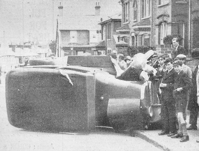
A car on its side in Hatfield Road above the Crown junction in 1929, and attracting much interest.
HERTS ADVERTISER
Oversized trucks, either by height or width, also blocked passage at the former Sutton Road railway bridge.  Many side scrapes have occurred along the narrow section of Hatfield Road between Laurel Road and The Crown, even in recent times.

The reason for widening next to the recreation ground in the 1960s was the number of accidents when visibility was poor around the  bend opposite West & Sellick (now CAMRA) and street lighting was still the pre-war installation.  Thick fogs were also quite common before the Clean Air Acts.  Heavy road rollers and steam carriers were known to be hazardous, especially those hauling trailers, or  those which unexpectedly off-loaded loose barrels, and especially vehicles which were attractive to small children nearby.  Sudden noises might frighten horses pulling carts or wagons and cause them to run away with their tow.

A delivery van made it too literal at the Co-op grocery in Blandford Road in 1933.
HERTS ADVERTISER
Although Camp Road was somewhat quieter, accidents were just as prevalent.  The early road was poor in condition in places, and in at least two places tree banks blocked part of the road near the school and at the former Oakley's dairy farm.

Today's traffic flows may be substantially busier and kerbside parking potentially more dangerous, but perhaps most of us are  better trained for driving and negotiating other road users.  That must count for something.