Showing posts with label Kinder. Show all posts

Sunday, 25 July 2021

A Place of Rest

 The north side of Hatfield Road was already busy with shops and homes by the time development began on the road's south side.  But there was one large creation which arrived before any other we have met so far.

The broad entrance drive at Hatfield Road Cemetery.

A number of fields around the edge of St Albans had been owned or rented by the Kinder family expressly to grow barley for the malting trade and the family's brewing business.  One of these fields is now the Hatfield Road cemetery and two further fields were replaced by the Granville estate.  When Thomas Kinder began to sell his interests the fields were transferred into the ownership of Earl Spencer.

On the west side of the central drive is the chapel.

The parish burial grounds, or churchyards in the second half of the 19th century were augmented by civic cemeteries under increased powers to local authorities, and St Albans Corporation surveyed the circumstances in 1880, discovering St Peter's was the only parish with a reasonable amount of burial space available. St Michael's, St Stephen's and Abbey were full. The authority therefore negotiated a price for the purchase of the field, at that time outside of the city boundary, to be used as a civic cemetery.  The ground was brought into the city in 1913.

Some of the entrance gardens.  The plantings vary from year to year.

The council was anxious to keep costs as low as possible, and having paid more than they had hoped for the land, further cost savings were sought after the plans were agreed.  An attractive sub-geometric layout of paths was begun, though this work was aborted as too expensive after the north-east quarter was complete; crops continued to be grown and sold for several years which further delayed the laying of paths.  Officially the first burials took place in 1884, although one or two earlier ones may have taken place.

Many cemeteries included two, or even more, chapels, but by not consecrating the ground a single chapel was considered acceptable.  An isolation hospital was considered for the eastern end, but not proceeded with.  A house for the superintendent was built inside the entrance drive in a style which matched that of the gateway wall.

Most of the cemetery is laid with rectilinear paths, though in the top right of this aerial photo
we can just detect evidence of the sub-geometric pattern of paths.
COURTESY GOOGLE EARTH.

This is probably an appropriate point to mention that if you are walking along the footpath outside the cemetery your route would have been inside the cemetery until the 1930s.  The narrow width of Hatfield Road extended from The Crown as far as Grimaldi's, although it had been widened further east.  There was therefore a need to make the same change along the cemetery frontage, shaving a full twelve feet from the boundary.  The hill section down to The Crown still has not been widened.

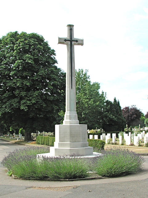
The cenotaph* occupies a central position, and part of the First World War  burial section
lies behind.

The cenotaph* was created in 1920 on the site of a former mound in line with the central drive, and a section of adjacent ground was reserved for the fallen of the First World War.  A similar area nearby  was created for the fallen of the Second World War, and both sections are separately maintained by the Commonwealth War Graves Commission.

For future planning the Council began to look at additional land which it owned for an additional cemetery.  A lawn cemetery was suggested for King Harry Lane; later the proposal shifted to Porters Wood; but eventually the new cemetery was created at London Road.  Meantime several authorities jointly planned for a crematorium on wooded land on the approach to Garston Manor.

An early autumn view across to St Paul's Church where a commemorative tablet can be seen,
commemorating the fallen in WW1 from St Peter's Parish.

Many Fleetville residents find Hatfield Road Cemetery a restful location to walk and sit.  It is very well maintained and has been a regular recipient of the national Green Flag open spaces Award Scheme.

The house built for the cemetery superintendent.  Today the title role is Cemetery Manager.

The local history group Fleetville Diaries has researched the stories of some fifty former residents who are laid to rest in this restful spot. A few of the graves have been restored in recent years, including that  of Frederick Sander.

*While a cenotaph is an ancient generic term for a specific meeting place to honour the dead who are buried elsewhere, this particular structural type, called a Cross of Sacrifice, was designed for the Imperial (now Commonwealth) War Graves Commission by Sir Reginald Blomfield.


Sunday, 28 March 2021

Pub on the corner

 No prizes for guessing that the one we're talking about is the Rats' Castle.  Against the odds by a substantial number of property owners – though not necessarily their tenants – it received its licence in 1927, roughly 85 years after the first building which farmer and land owner Thomas Kinder allowed to be built on the edge of his farm.  Kinder was a trustee of the Reading and Hatfield (R&H) Turnpike Trust, of which Hatfield Road was part.  A number of road users discovered they could make use of the road without paying a toll by taking an alternative private track, now Sutton Road, without passing the toll house at the Peacock PH at the edge of the town in Hatfield Road.  Around 1840 Mr Kinder agreed with his fellow trustees to erect a simple toll house; a map shows it to have been a small cross plan rather like a four-bay barn form familiar to farm environments.  From observations made at the time it appears to have had a straw roof, and probably had a central fireplace with a chimney emerging from the highest part of the roof.

The road crossing the map between left and right is now Hatfield Road. The private farm track
leading to it is on the edge of Beaumonts Farm.  The pink cross-shaped building was the toll 
collecting building on the side road, which, today, is Sutton Road.  MP was the location of the mile
post halfway along where Bycullah Terrace would be built c1900.  A few years later the post was moved further west (so therefore not strictly accurately placed).  This map is from 1879.

As it was intended to catch toll evaders rather than regular traffic it is likely that the tollkeeper's presence was intermittent.  Further,  closure of toll charging was widely anticipated, possibly up to a decade in advance, and the R&H Trust was not known for its diligent  record keeping the toll house may have been empty for some time.  However, it was at least standing when a map in 1879 was issued.

By common knowledge the roof spaces were occupied by rats and by the 1880s the local landmark was commonly known as the Rats' Castle, and the field in which it stood was equally well known as Rats' Castle Field.

The enumerator's route description for the 1891 census.  In the centre of the red circle is the
name Rats' Castle (with a following apostrophe) identifying both the former toll house
and the corner of the field in which it had been built.

The old tollhouse had been demolished as soon as Mr T E Smith's nearby printing works arrived in 1897; an opportunity for Mr T Cooke to take advantage of the site for a house and shop, which was known as Primrose Cottage.  It is possible plans by Smith for shops opposite the works were unknown in the public realm, but Mr Cooke and then Mr Percy Stone both sold beer and spirits in addition to  stocking a range of grocery items.  Swiftly businesses and homes grew up in the Fleet Ville district; a number of their owners objected to the sale of alcohol.  In the case of spirits only large bottles could be purchased anyway, beyond the pockets of most residents but possibly not their landlords or employers!

Primrose Cottage shop when it was managed by Percy Hector Stone.  He would later move
across the road to trade from Bycullah Terrace.  This building had a short life of less than thirty years.
COURTESY ST ALBANS MUSEUMS

Two well-known businesses had already attempted to open hotels and public houses: Trust Houses and Benskins.  Animosities occasionally flared up between vested groups through to the 1920s.  Benskin's had a "Plan B"; it acquired the ownership of the corner shop because it had already secured its off-licence shop and spirits supplier from the previous occupant P Perkins, and installed its own tenant, C Griffin and then George Hopkins.

Finally, Benskin's received its full on-licence in its own right, and engaged local architect, Percival Blow to design the new building, the frontage having distinct echoes of Primrose Cottage and shop.

The 1920s public house which replaced both the toll house and Primrose Cottage.
Somewhere on the site there will probably still be evidence of a well.  Architect: Percival Blow.

"The Rats" as it became known to regulars, has never been short of clientele.  Benskins at one point during the 1970s decided that the rodent might put off possible customers, and an adapted hanging sign  went on display with the name The Castle.  The new name did not last long, thanks to some sterling defence by regular customers, and even Fleetville residents who would not normally take up such a cause.  Within a few months the traditional title returned.

The short-lived hanging sign for The Castle –
without a rat in sight!


But one aspect of the sign never wavered; the artists, presumably under company instructions, have never included an apostrophe, when a following apostrophe would be expected by default, a singular rat not being sufficient to sustain a population of the rodents to maintain the story, which may remain unique in the UK – but it would be great to have this confirmed.

If the Rats' Castle is on one corner of Sutton Road we might think Ballito was on the other.  Next time we will discover whether that was true.

Sunday, 24 January 2021

St John's and Lane End

 A message received this week stated "In my endeavours to discover the history of St John's Court I most happily came across your site ..."  The editor very much appreciates that you did, Rebecca, as the north end of Beaumont Avenue is often recalled; the former Beaumonts farm workers' cottages on one side, and two large houses on the other.

A substantial acreage of Beaumonts farm was disposed of for development in 1899, the remainder in 1929.  In this context it included land between the west of Beaumont Avenue and the former stream course at the foot of the hill (where Salisbury Avenue meets Eaton Road).  The first house to be erected after the 1899 sale was St John's Lodge, first occupied by 1905 and possibly a little earlier.  The first name applied to this address was Avenue House.

There is a connection between the former owning family of the farm and the owner of Avenue House (later St John's Lodge).  The Kinder family had been farmers and brewers since at least 1737, and in addition to Beaumonts Farm Kinder either owned or rented fields to grow oats and barley for the brewing trade.  He also had interests in the highly successful brewery, the business of Stephen Adey and Samuel White in Chequer Street (where The Maltings shops are today and in the first half of the 20th century had been the Chequers Cinema and the Central Car Park).

The houses Bramhall, Lane End and St John's Lodge consumed an estimated
five acres at the north end of Beaumont Avenue. Ordnance Survey 1939.
COURTESY NATIONAL LIBRARY OF SCOTLAND


Harold Adey had been living in a villa in Verulam Road, but was the first to acquire a strategically positioned plot in the newly laid out development land of The Avenue and Salisbury Avenue.  Was it just coincidence that Harold Adey purchased his new house here?  After all in 1900 Thomas Kinder had been dead for nearly two decades.  But there might have been a provision in Kinder's will.  His trust was empowered to sell assets over a period of time to ensure his wife and daughters had solid futures.  Nevertheless it had previously been  Kinder's former brewery,  and here was current owner Harold Adey building his own house on part of the Kinder estate!

Only four other homes were built in the Avenue during the next fifteen years.  And next door at the very end of the avenue the variously named The Grange, Stoodley and Lane End appeared for a Miss Hough. Meanwhile Avenue House changed its name to St John's Lodge.  Both properties had a footprint of around two acres each.

In the 1920s the Misses Blackwood began a small private school from their St John's Lodge home, which by the mid 1930s had moved as a "prep school" to the eastern end of Jennings Road.

St Albans Councillor William Bird made St Johns Lodge his home from c1937, before moving on to The Park in the 1950s.

This pair of neighbouring houses were the location of Conservative Association fund-raising garden parties during the fifties.  Mr Williams at Lane End was an extensive rose grower, and it is said that he had over 1,500 rose bushes in his garden.  On garden party  days, visitors were able to use a gate between the two homes and, maybe, for a small surcharge could walk around the Lane End gardens to enjoy the flowers.

The three houses were in the area marked in green above.  Today nearly seventy homes
occupy the same space.
COURTESY GOOGLE EARTH


They may have continued to provide homes for future owners, but there was also interest by developers searching for house building land.  By 1960 the end had come for both homes.  They were demolished, together with the Sandpit Lane-facing Bramhall and by 1966 permission had been given for a new development of 69 homes, collectively taking the name St John's Court.  A new future for the northern end of Beaumont Avenue lay in wait.

It would be great to find photographs of either or both of these houses to illustrate just how impressive they were in their day. Meanwhile, there are probably many readers who have other recollections of these houses.

Meanwhile, the following memory has been received, and it seems appropriate to add it to the above post.

"I spent lovely afternoons playing [at Lane End].  A friend and I were invited by Mrs Williams to tea.  We were sent in our best frocks, but Mrs Williams told us to come in clothes suitable for play the next times we visited. It was a wonderful garden, huge, with a little bridge and big trees to climb.  Roses galore, and we played croquet too.  The house was beautiful, and attics to explore and a green marble bathroom.  Mrs Williams was a kind lady.  I'm not sure if she had children, but we had such happy times there.  I was dismayed when Lane End was sold and that such a lovely house was demolished.  My father was most unimpressed with the new development."