Sunday, 9 October 2022

Absent Photo: Original Rats' Castle

 The first in our series of absent buildings which have left no known visual trace occupied a well-known plot in Fleetville.  Mention the Rats' Castle to anyone who has ever lived in our around Fleetville and they will identify with the corner of Hatfield Road and Sutton Road.  The Rats' Castle (inevitably printed without the apostrophe) public house has been a landmark here since 1927; and there is a reason why the building sits at this spot.

The latest of three buildings which have occupied this corner of Hatfield Road and Sutton Road.
The Rats' Castle PH opened in 1927.
When we pull out photographs of this corner we are inevitably shown a view of the current structure designed for Benskin's by architect Percival Cherry Blow and opened in 1927.  Many versions have been taken: with or without floral displays, and with one or another of several hanging signs interpreting the name of the pub using the artist's imagination.  We'll return to the name shortly.

Primrose Cottage was first a dwelling but was subsequently partly converted into a shop.  It seems
that the windowless rear extension was added at this time, with a boundary wall against the
recently converted track into Sutton Road.  Part of either 1 or 3 Castle Road can just be seen on
the extreme right.
COURTESY ST ALBANS MUSEUMS
Alternatively, a fine monochrome print of the building which the public house replaced, Primrose Cottage, completed c1895.  The title suggests it was constructed as a detached dwelling, but within two years construction work began on a large printing factory, the Fleet Works, and nearby workers' homes which were given the collective title Fleet Ville.  Until that moment Primrose Cottage was alone in the countryside, the nearest dwelling over a quarter mile away.  No time was therefore lost in converting part of the ground floor into a general store, and, as far as we know was first photographed c1903 after shop conversion under the management of Percy H Stone.

If you compare Primrose Cottage and its shop with the later public house it is possible to spot similarities in some of the design elements. There is just one known image of Primrose Cottage and shop, but I wonder whether, during its thirty year life span other views existed – still exist.

A section of the 1879 Ordnance Survey map shows the Hatfield Road (in brown) and the turnpike toll house (in red).  At the bottom of the extract is the low embankment of the Hatfield & St Albans
branch railway.  The former track, later renamed Sutton Road, then tree-lined, is between.
COURTESY HERTFORDSHIRE ARCHIVES & LOCAL STUDIES
Before either of the above buildings had existed a far more basic structure had been erected on the same footprint.  Although there is no proof of the wall materials – probably brick – we do know from recorded recollections that the roof was thatched and that it was a "little square" in floor area.  Its function was to house a turnpike toll collector (the road between Hatfield and St Albans was part of the Reading & Hatfield Turnpike Trust).  The track beside the little building later became Sutton Road and was on the edge of Beaumonts Farm owned by Thomas Kinder who also happened to be a trustee of the Turnpike Trust.  He gave the land on which the toll house was to be built and which enabled tolls to be collected before travellers set foot, wheel or hoof on the turnpike.  The track belonged to Mr Kinder and so he had a double interest in benefiting financially.  We know the toll house was erected before 1879 as the Ordnance Survey map of that year informs us, but the only known earlier record is the 1840 tithe map which is absent on the matter.

The rest of Broad Field was sold for development in 1899.  By then it was known locally as
Rats' Castle Field.  This photograph shows the upper end of Castle Road.
COURTESY HERTFORDSHIRE ARCHIVES & LOCAL STUDIES
Formally called the Hatfield Road toll house it was given up by the Turnpike Trust and continued to be occupied for a time before being abandoned by 1890.  It became rat infested, the rodents making their  homes in the straw roof.  Passers by had already given it a nickname by the time of the 1891 census: "the rats' castle". The building was identified as such in the 1891 census, and the field in which it stood, previously known as Broad Field, was known as Rats' Castle Field.  When in c1899 houses were built on part of the field the road was named Castle Road.

While we have been able to build a story based on those facts available to us no-one has brought forward a photographic image or a reasonably accurate pencil drawing or water colour painting.  We know where it was located from map evidence but we are badly in need of a photograph or drawing.  Let's get searching.

For further details of the above buildings on this site:

http://stalbansowneastend.org.uk/topic-selection/rats-castle/


Monday, 3 October 2022

The Quadrant Local Shops


The coloured base map shows the area covered by The Quadrant (in red).  The black overlay is the
former site of Marshalswick Farm (which had previously been known as Wheeler's Farm).
Marshalswick Lane is the curved road lower left; Sherwood Avenue (previously called
Woodlands Avenue) branches almost northwards from Marshalswick Lane.
COURTESY OPEN STREET MAP CONTRIBUTORS and NATIONAL LIBRARY OF SCOTLAND


A quiet period at The Quadrant recently.  Marshalswick Lane curves across the bottom of the image.
COURTESY GOOGLE EARTH

A mid 1930s proposed plan of part of the New Marshalswick estate. The red circled area is labelled
"School site - at present Marshalswick Farm". This would later become the site of The Quadrant
instead.
COURTESY ST ALBANS MUSEUMS

We can forget a cluster of four or five retail units round the corner or along the street, such as we've explored recently.  This week we've come to explore the daddy of them all, standing back proudly behind its own bend along what was known as the ring road – Marshalswick Lane – with its own pair of roundabouts.  This is The Quadrant, sporting its own definitive Article built into the title.  While intended to serve both old and new Marshalswick, today it is more widely signposted as a destination.  If the definition of Local Shops is a location you could walk to, in the case of The Quadrant it rather depends on how fit you are. While the centre's car parks (plural) have always been busy their main function today appear to serve more distant visitors.  As for bus services, if you live halfway along Charmouth Road, or anywhere else in Old Marshalswick for that matter, you are effectively as far from local shops as the city centre.

A view of the centre block at the front of The Quadrant in 1959.  There are as yet unoccupied
premises and an almost empty car park.
COURTESY CHRIS CARR


The developer placed an advertisement for potential tenants in the Herts Advertiser. Twenty-one of
31 shops in phase one were currently let.
COURTESY HERTS ADVERTISER


The Quadrant's gestation goes back to the mid-thirties when Marshalswick Farm was sold for housing following the eventual sale of Marshalswick House. T F Nash, a north London developer, published its initial plan for "the estate" meaning new Marshalswick, for old Marshalswick was already in build.  The road now known as Sherwood Avenue was to be a shopping street with units on both sides, and a cinema – possibly a multi-purpose hall.

But the style of the 1930s, replicated in dozens of north London residential estates alongside or spanning major roads, did not suit post-war retail layouts.  Instead a large swathe of the new estate was classified as a high density zone for flats, schools, shops and other services.  The former farm was still standing together with its barns, ponds and wooded surroundings, and in 1957 work began on clearing the site and creating phase one of the shops.

In a blog of this size it is not possible to plot the many changes which have taken place in the past sixty years, but a second phase was added from the mid-sixties, with an additional five shop units to lengthen both wings, although a sixth unit was created on the south  side by the expedient of dividing one full unit into two halves (the first iteration of Marshalswick Carpet Company, and Terry Watts, hairdresser).

The early days of the north wing, part of which was developed later, included a Chinese food outlet, Neighbourette laundrette, Wright's grocery, Kristian ladies' hairdresser, Norbury greengrocer, and the double-fronted corner shop was held by Victoria Wine.

Phase two of the southern wing showing a double unit occupied by Barclays Bank, which went
on to be joined by Lloyds Bank in the same block. Both have now left.
COURTESY BARCLAYS ARCHIVE

Phase one and phase two blocks on the south side taken c2012.  Opposite are the branch library,
community centre, M&S Food Hall (formerly The Baton PH) and Sainsbury's Local.


The south wing's double fronted unit launched with Giffen's Electrical (although this was soon followed by Darby's Radio and then Sherriff's Garden Shop).  The rest of the lineup included Micheline de Paris ladies' hairdresser, Drummonds toys and sports, Martin's newsagent and Post Office, Allen's hardware, Marshalswick Motors, Marshalswick Carpets, and Terry Watts men's hairdresser.  This side also features branches of Barclays and Lloyds banks, and the estate office of T F Nash, later McGlashan & Co.

The long sweep of the front road began with a double unit in the centre: Marshalswick Car Sales, although this seemed to be a temporary arrangement as the company moved to a separate building fronting Marshalswick Lane where today's Sainsbury's Local and petrol forecourt is.  Bishops Stores nestled into the double unit by c1965.

A full page advertisement placed in the Herts Advertiser by the DIY shop
Edward Carter, who also had a shop in the parade at Beech Road.
COURTESY HERTS ADVERTISER

From left to right the early shops included R J Blindell, shoes; Josephine, newsagent; C J Martin, chemist; Edward Carter, hardware (today we would called it DIY); The Woolshop; Notts bakers; E Butler, butcher; Pearks Dairies; Gerrard, fruiters; Kingston butchers; E Wright, watch maker and repairer; Longman's baby shop; Alicia, drapers; Andrews, outfitters; Eastman, dry cleaners; Marshalswick Furnishing (although a cycle shop existed here for a short time).

The frontage view of The Quadrant seen from Marshalswick Lane.
COURTESY GOOGLE STREET VIEW

That's quite a range for everyday as well as more specialist  requirements. But how have our apparent needs of yesteryear become our apparent needs for today?  As in many places the hardware/ironmongery shops have disappeared to more distant warehouses on retail parks.  Our groceries have become more diverse – the size of Budgens is identical to earlier Bishops, although next door's McColls may, by the time you read this, have morphed into a Morrison's Daily, but Sainsbury, which once wanted to make a sizeable appearance at Jersey Farm, now occupies a prominent location close to another even more prominent position at M&S Food – for readers who have moved away from the district in recent years the Baton PH was located here.

If the definition of Local Shops is a location you could walk to, in the case of The Quadrant it rather depends on how fit you are. While the centre's car parks (plural) have always been busy the main function today appear to serve more distant visitors.  As for bus services, if you live halfway along Charmouth Road, or anywhere else in Old Marshalswick for that matter, you are effectively as far from local shops as the city centre.

We now appear to crave more food on the go, and although Fish and Chips had made an appearance from the earliest days, Subway and Greggs have been added to the list.  Not to mention a Chinese,  Italian, kebab, KFC and Molen's cafe.

Not surprisingly I suppose, the banks, of which there were two, are now absent.  On the other hand, no-one felt the need for an estate agent, but now there are four.  There are also three charity shops and a kitchen design service for the five thousand homes which are apparently looking more old fashioned since the 1960s.  

Whatever the mix there is bound to be plenty of variety and competition among over forty shops, much as there has been since this retail adventure launched in 1959, gradually replacing the ad-hoc trade provided by a small number of mobile shops and delivery vans.

Monday, 26 September 2022

Jersey Farm Local Shops

 You will have noticed no reference yet to the largest centre of local shops – The Quadrant.  We will, naturally, get round to it, but it does seem right to reference The Quadrant during the planning period for its much smaller neighbourhood and rival at Jersey Farm.

Jersey Farm homestead closed up and ready for redevelopment in  the 1970s, but consumed
by fire before enjoying its new lease of life as a community facility.
COURTESY TREVOR PARSONS

Jersey Farm residential area had barely been conceived when its larger neighbour was already maturely complete with its retail offering open to the world.  In fact, much of the 1970s seemed to be occupied by arguments about whether or not there should be any houses at all at Jersey Farm; the original plans for the estate (or mini-town as it was referred to) included a northern bypass and two schools, but all were ditched as was a proportion of the housing stock, on the pretext of – well, that's another story!


The range of shops and the Blackberry Jack PH at and around The Harvesters (not, as shown, Harvest Court).  Aim for St Brelade's Place to park the car.
COURTESY OPEN STREET MAP CONTRIBUTORS

The site for services and shops was to be around an upgraded farm house at newly named St Brelade's Place, a reference to the island and its cattle breed raised and maintained at the former farm.  However, a serious fire at the farm house scuppered the plan before it was even begun.  And so the services available to residents today were all new-build.  Today, if you drive along Sandringham Crescent, the main spine road, two other names will stand out before you ever see the word St Brelade's Place, which is a short connecting street round the back of the shops.  The first is the side road joining the main spine, which was given the name Harvesters; the second is the community and family pub on the corner, named Blackberry Jack, referencing a local legend.  The Blackberry Jack is the only public house which is part of a local shopping hub in this series.  Quite an accolade!

The Blackberry Jack community public house, operating under the "Sizzling" brand.

Another boost is the provision of doctor, dentist, pharmacy and post office services.  The local grocery is in the form of a Tesco Express – and without a grocery anchor any local shopping parade would become unstable.  It is supported by three other eating options; Chinese, Indian and a traditional fish 'n' chips.  And to complete a useful collection St Albans Cycles has a bicycle shop, which is brilliant now that we are all being encouraged to revert to two wheels and leave the car at home (or sell it).


Residents of the wider district or Jersey Farm itself will know there is more to the retail back story than is described above. With the early developments already progressing in the mid 1970s, the intended "supermarket" provider was slated to be Key Markets.  Which is when the backlash from a few of the Quadrant traders began.  Key's intention was to service both JF and Marshalswick with one large store – hence the term supermarket we suppose.  In time this brought Sainsbury into the fray, which proposed a larger footprint than Key had proposed or the developer was offering.  The City Council, as the planning authority, urged Sainsbury not to push so hard as there would be no increase in the number of homes at JF.  The term "mini-town" had had its day, St Brelade's Place would be an appropriately sized hub of local shops, expecting common sense to prevail.  As it still does.


Tuesday, 20 September 2022

Russet Drive Local Shops


Hill End Lane at the foot of the picture, with Russet Drive extending northwards between the two
blocks.
COURTESY GOOGLE STREET VIEW

Not far from Cell Barnes Local Shops is a very small group of shops alongside Hill End Lane in Russet Drive.  Although this road appears short in length, walk or take a car between the shops Russet Drive turns left and winds its way northwards to join a roundabout, passing a number of short culs de sac, all named after varieties of apple.  One of the features of the former Hill End Hospital upon which the new residential area of Highfield was built were extensive apple orchards.  It is Russet Drive, opened c2000, which gave the little group of shops and other facilities their name.

A bunch of Russet apples.

The retail units are not arranged in a strict line, but informally around a small car park.

The largest unit is a Spar general opening out onto four sides, and has by far the largest footfall.


Top: Spar General store. Second: front group of shops. Third; Community Surgery.  Bottom; YMCA building behind the car park.
COURTESY GOOGLE STREET VIEW
Backing up this prime shop are J Hoots, Pharmacy and a small surgery.

Alphamarque mobility specialists, Saints Barbers and Sushi 4U complete the series of units, although there remains one empty shop c2020. We should not, however, omit a useful free withdrawal bank machine.

Nearby are the YMCA Community Gym, Fusion Performing Arts and Tumble Tots.

Hill End Lane on the left.  The two red retail blocks with Russet Drive between.
                                                                                               COURTESY OPEN STREET MAP CONTRIBUTORS

But, of course, the extensive Highfield Park and its Millennium Maze, meadows, woodlands and Village Green are on the doorstep.

Topics specialising on the former Hill End and Cell Barnes hospitals can be found in https://www.stalbansowneastend.org.uk and regular events are announced in the Highfield Park Trust website https://www.highfieldparktrust.co.uk

A section of Highfield Park.
COURTESY HIGHFIELD PARK TRUST
There is much variety to be found and not just in the immediate vicinity of Highfield; where Drakes Drive meets Ashley Road, Hill End Lane, Highfield Lane and Tyttenhanger Green Lane all benefit from the local shops.  Even the eastern end of Camp Road, which once thrived with small shops, now require householders to walk to Russet Drive as an alternative to Cell Barnes Lane.

Thursday, 1 September 2022

Cell Barnes Lane Shops

 For the third of our short summaries about local shopping parades scattered around our East End we are visiting Cell Barnes Lane.  Until the early post-war period residents living in the Camp district called in at one or more of the traders whose businesses were spread intermittently along the winding Camp Road, which was the city's south-western residential limit, with the exception of a number of 1920s semi-detached homes on the Springfield estate along the northern section of Cell Barnes Lane.

This week's retail hub in Cell Barnes Lane, the road which crosses the picture from left to right. 
The shopping building is book-ended on the left by Cornerstone Church and the Adult Day Centre
(the former branch library) on the right.
COURTESY GOOGLE EARTH

During the 1930s the Council had acquired ownership of a substantial amount of land forming the major part of Cunningham Farm, Little Cell Barnes Farm, and land holdings around Great Cell Barnes.  Post-war housing expansion would include developments to extend residential development from the end of Windermere Avenue as far as London Road.  Consequently, it was labelled London Road estate, but also known as Mile House estate.

Much of the land consisted of the active Camp Allotments, most of which would eventually also be built on.  However, moving allotmenteers to other available plots took time, and the need for the council to acquire a sufficient number of building licences delayed groundworks, and it was the end of 1959 before the first 250 dwellings were complete.  The layout  followed a familiar pattern for larger new estates; blocks of flats, shops, schools and community buildings were concentrated on what became known as a high density zone; in the case of the London Road estate this was either side of Cell Barnes Lane.


Two recent views of the eight retail units (but six shops) at Cell Barnes Lane Parade.
COURTESY GOOGLE STREET VIEW


It appears that the number of local shops was determined broadly by the number of homes in the development.  So, a block of eight shop units, topped by flats and maisonettes, was arranged on the east side of Cell Barnes Lane between Thirlmere Drive and Grasmere Road, sandwiched between a pair of community buildings: a community church and what was intended to be a community centre (the latter was re-allocated instead to a former building of Little Cell Barnes Farm, and the site on the corner of Grasmere Road instead became a branch library for the City of St Albans Libraries.  This site is now an adult day care centre.

The red and cream building is now the Adult Day Centre but was first built by St Albans City
Council for one of its branch libraries, now regrettably permanently closed.
COURTESY GOOGLE STREETVIEW


Cornerstone Church which, when first opened, was named Thirlmere Church as it was sited
on the corner of Thirlmere Drive and Cell Barnes Lane.


We may wonder today that the number of shops mentioned above was eight, for today there are just six.  But the units were numbered 191, 193, 195, 197, 199, 201, 203 and 205.  Two end projecting upper floors with six single units between, all the shop frontages  being protected by the balcony floors above.  In front of the paved walkway it had been intended there should be a grassed barrier strip behind the road as public open space, but right-angled parking bays were provided instead.  If these were to be local shops they would have been in walking distance from people's homes; instead, the assumption was made that residents would drive most of the time.

Rather surprisingly I have no record of the very early traders occupying the units in Cell Barnes Lane – readers who have a keen recall are welcome to get in touch by responding to this post directly, or by using In Touch from the website.  In more recent years the occupiers have been:

191    Blitz Autobitz

193    Laundry (in 2009); now Seaworld Fish and Chips

195    Martin's sub-Post Office

197    St Albans Pharmacy

199    Co-operative Food/Cell Barnes Co-op

201    Co-operative Food/Cell Barnes Co-op

203    Co-operative Food/Cell Barnes Co-op

205    Hulse Fruiterer (2009); The Smoke House Deli (from c2015)

It is thought that 195 had previously been a McColl's grocery, so perhaps a newsagent had been next to a smaller Co-op.  The range of goods and services available is generally those available at a local shopping hub, although it does lack an ironmongery – but in how many such parades are to be found an ironmongery shop these days?  Wine shops are increasingly popular but is not represented in Cell Barnes Lane, nor is there a public house, The Camp PH having closed and replaced some years ago (so too was The Mile House, although both the Rats' Castle and the Crown are very much in service).  CBL is fortunate in having both a chemist and a sub-post office, the latter with a posting box.  Cycle racks, notice panels, bench seating and mature trees add to the offer.  The southbound bus stop is a short distance beyond the shops, but in the northbound direction the stopping points are both some distance before and after the shops.  It would be useful if greater priority is afforded to the bus directly opposite the shops, especially as a pedestrian crossing is immediately north of the parade. 

Within a short distance are the combined Cunningham Hill Infant, Cunningham Hill Junior, and Windermere Primary schools, all of which provide busy parental footfall at the beginning and end of the school day.

The newly complete Warner House, Cell Barnes Lane.


The Cell Barnes electricity sub-station built in 1951.


As a pair of asides, a smart new building, Warner House, has recently been completed to replace the now-demolished Wavel House.  The new address provides flatted accommodation for 24 over-55 occupants who wish to downsize, so providing a range of larger homes for families.  Next door is the rather unsightly electricity sub-station, built in 1951 and intended to reinforce supplies directly from the then-new generating plant at Hoddesdon.  Perhaps, after 70 years the street side of the site would benefit from a refresh!


Monday, 22 August 2022

Oaklands Local Shops


The green line defines the farm field sold for development at Winches.  It just comes within the city boundary redefined in 1913, although the farm buildings themselves remained in the rural district.
COURTESY NATIONAL LIBRARY OF SCOTLAND


The former farm field now developed as Wynchlands Crescent and the shops lining Hatfield Road.
The western end of the Crescent has been renamed Wynches Farm Drive and now leads to a
new estate built on the remaining fields of the little farm. The road end of the former farm lane
has now disappeared under part of Glenbower House.
COURTESY GOOGLE EARTH

 More traditionally known as Wynchlands, Winchlands Parade is the row of shops at Oaklands which arrived on the scene as a result of the opening up of the eastern borders of St Albans in the 1920s.  Hill End Farm had been swallowed up by Hill End Mental Asylum in 1896, but surplus land from the farm came on the market in 1920 and plots were offered for sale along the southern side of Hatfield Road from the proximity of  Ashley Road eastwards as far as the track to Butterwick Farm (adjacent to Homebase store).

Meanwhile, on the north side of Hatfield Road lay the diminutive Winches Farm – no more than three fields, a farm homestead and a couple of outbuildings.  The background of these developments was the extension of the city boundary in 1913.  Previously the city extended only to The Crown, but the new marker was pushed out as far as Winches (although I have never discovered the actual marker post it should be in the location marked with the red arrow on the annotated map above).


The above four images illustrate the Parade and semi-detached homes beyond, taken c2010.

The Winches field adjacent to Hatfield Road – and next to the triangular entrance to the little farm – lay higher than the road, a topographical feature still visible today, where the shop fronts and pavement are at the front of the field level, the original slope towards the road now in the form of up to four steps – the parking bays at the lowest, adjacent to the road.  Not that the bays are used as intended; vehicles are parked at right angles and with front or rear wheels at a higher level.  When the Parade was still young and before the main road was fully made up at its current width, there was a strip of rough grass in front of the footpath.

The parade consists of twelve semi-detached buildings; most of the shops being at the west end with homes further east.  The exception being the General Store on the eastern corner of Wynchlands Crescent.  While the houses are strictly semi-detached properties with genuine spaces between them, the first six pairs are connected as if terraces, having enclosed and arched sideways between them, with the western side flats extending over the covered way.

Since twelve is a substantial number for purely local shops, would the parade have included a smattering of specialist retailers not found elsewhere in Fleetville?  The answer to this question is rather more muddled than might be imagined for a newly completed estate. The 1930 Kelly's directory is the first to name the new coming occupants of the houses, and it is not until 1934 that the shop occupiers begin to trickle in and are named – and for many of the addresses no trade is  added, perhaps indicating the properties began as residences.  In fact, a butcher (399), an engineer (401), a tailor (413), a general store (417) and corner store (447) were the only shops identified before 1946.  However, during the 1950s and 60s the choice for shoppers widened. In 1960 there was:

399 W Jones, butcher

401 H Cocks, engineer (changing to J Adams, fruiterer in 1966)

403 A greengrocer

405 E Adams, footwear

407 Oaklands Fisheries

409 Mrs Hemmingway, confectioner

411 Ladies hairdresser

413 Milliner and wools

415 Selina Gowns

417 Wine store

419 Upholstery, later Oaklands Electric

421 Oaklands Electric

447 Grocer

At the same time opposite the parade on the south side of the road was a house conversion (444) into a general store and sub-Post Office. 

The parade therefore offered a wide range of merchandise, the clear omissions would have been an ironmonger, baker and a chemist, for which a longer walk or short bus ride to Fleetville would have been required.

The western end of the Parade in 1964.  The left house (after the former Bunch of Cherries PH
sign) had been occupied by electrician Mr H G Cocks, who later moved his business to number 401,
the building with the hipped roof.  Mr Cocks's house has now been replaced by Glenbower Court.
COURTESY ST ALBANS MUSEUMS

The basic bus stop of 1964 now has a shelter.  It was also the period before the convenience of
customer car parking.  Potential customers were also welcomed by sun blinds.
COURTESY ST ALBANS MUSEUMS

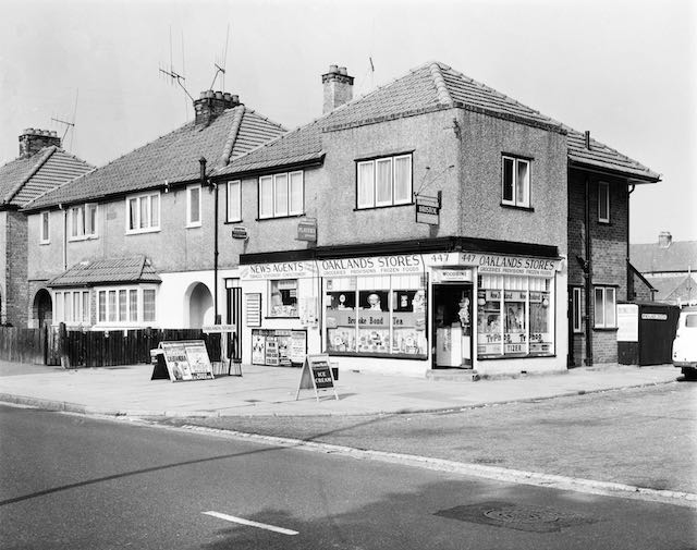
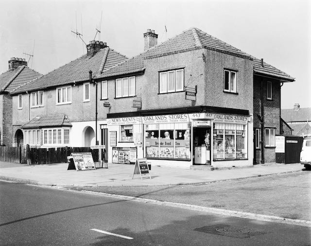
At the end of the Parade and houses is the literal corner shop.  All of the windows in 1964, 
including the smaller window probably part of the original domestic accommodation, were used
for display.  Today, the main windows are covered by enticing marketing for products sold
inside and the forecourt is more cluttered than shown here.  The posting box has now been
moved from its 1964 location on the south side of the road where the sub-post office had been.
COURTESY ST ALBANS MUSEUMS

Today, numbers 419 and 421 are no longer shops, having been converted into residences, and most of the "useful locals" have disappeared altogether, those roles being maintained solely by Oaklands Stores at the eastern end.  Even the former store and sub-post office is now converted into a branch of J J Burgess, Funeral Directors.

So, the recent line-up for the parade is Hair Extensions, a men's hairdresser, Plumbing & Bathrooms, a house agency, a fish & chip shop, a bargain shop, a recently closed blinds shop, a flooring supplier, an oriental takeaway and a wine shop.  The parade is now supporting a considerably larger numbers of homes along Hatfield Road from Ryecroft Court to Wynches Farm Drive, Austen Way and Marconi Way.  No wonder the car parks at larger more centralised stores are regularly busy.

Early photographs and recollections of the Parade and its environs would be especially welcome: saoee@me.com

Update 28 Aug 2022:

Boundary posts for the 1913 city extension are extant at Sandpit Lane (near Damson Way)  and Hill End Lane (between Nightingale Lane and Frobisher Road), but it seems illogical that such a post would not have been fixed at the Hatfield Road location, this being where the boundary crosses by far the most important road leaving the district.  It is therefore likely that one had existed but has since been removed.  Does any reader have knowledge of a 1913 post here?

Above I have suggested that the Parade did not include an ironmonger's shop, but this seems not to be the case.  A former resident from the early days of the Parade recalls the detached building (397), which was occupied by Mr Cocks – which Kelly's Directory refers to as "Engineer", in practice operated as an ironmonger's shop.


Sunday, 14 August 2022

Central Drive shops

Central Drive crosses the picture from left to right, with Hazelwood Drive and Woodland Drive intersecting to the left and right respectively.  Central Drive shops are in the centre, to the left of the six blocks of Irene Stebbings House.  Until the shops appeared the land was an informal green space where children played.
COURTESY GOOGLE EARTH

Corner shops in the suburbs have always remained popular despite the near universality of supermarkets.  In the early postwar years their owners fought hard against the branded stores, as of course did the small independent hardware shops and butchers in the side streets and residential corners.  Somehow many of them survived with new owners willing to commit to even greater hours and seven day trading.

One of many corner shops in Fleetville, this one being Bransons at the junction of Harlesden and Burnham roads.
COURTESY THE GORDON JAMES COLLECTION

St Albans City Council also committed to serving its tenants on the many residential estates which were considered to be remote from essential shopping locations; blocks of three, four or five lock-up shops with separate flats or maisonettes above, appeared in locations such as St Stephens Avenue, Bricket Wood, Cell Barnes Lane and Central Drive.  These developments came about in the late 50s and early 60s, and were intended to bring opportunities for essential purchases without leaving home for the city centre.  We must remember that car ownership was still relatively low, refrigerators and freezers were nowhere near universal and modest kitchen dimensions often precluded space for generous storage.

The Newgates Cottages.  The left house included a general store during the 1950s and 1960s.


St Albans Co-operative Society invested in several mobile shops to take its products to where
people lived.
COURTESY GORDON JAMES COLLECTION

The nineteen thirties and early post war estates rarely came neatly packaged with extra facilities; just houses.  The Beaumonts estate, begun in 1930, required tenants and owners to walk either to Fleetville or to Wynchlands Parade, although a general store had opened in one of the Newgates Cottages in Sandpit Lane, at one time run by the Sanders and Dench families.  Various vans and old coaches were pressed into service as travelling shops, and the Co-operative Society purchased specially designed mobile shop vehicles which pulled off the road for a couple of hours weekly.  A fish van arrived on occasions.  While we could be served today by the home delivery vehicles of all of the major supermarkets, this is not new; we  were well served by bakers, grocers and milk. Oh, and regular jingly visits were made by an ice cream van. However, there is no doubt the Council's proposal to make use of land in Central Drive to bring retail closer to people was a huge attraction.


Recent images of Central Drive shops.  Unfortunately, no images could be found of the shops
in their early days.


Five such shops opened in 1960, which, on the whole, could be classed as useful; the Council determined the classes of retail which could be traded.  Unfortunately I could not locate a photo of the Central Drive shops early in their life.

Number 13: Greengrocer, first Bonella and then Watson;

Number 15: Grocery, first Home & Colonial, then Hilkene and S&V Stores;

Number 17: Newsagent & confectionery, Mr Bates;

Number 19: Wools, (Gayes), changing to a ladies' hairdresser (Kay)

Number 21: Ironmongery, first Mr S Wrightson, and later by Mr Barrington.

The ironmongery later changed trade; Mr J Patience took over the lease and traded successfully as a butcher.  His customers often came from further afield than the local estate – and of course the name had been well known for butchery on the east side of St Albans since Fleetville itself began.

Returning to Central Drive in recent years I was keen to discover whether the essential nature of the local shops had survived.  Using a rough-and-ready checklist on potential purchases, I intended to seek out some carrots, a tin of peas and loaf of bread, a newspaper and chocolate bar, and a shelf bracket and spare battery.  None of these is available here today.  Instead, we have a cafe, a photographic studio, an off-licence, and no fewer than two hair dresser/stylists.  There used to be a quiet conversational buzz in front of the units; the greengrocer also sold postage stamps; in the period before mobile phones and before most homes had landline phones a public phone kiosk was located to the right of the fifth shop.  But you can at least  still post a letter on the pavement pillar box.

Today, of course, The Quadrant is not far distant and does offer a significantly wider choice.  And it is still possible to walk to Wynchlands Parade or Fleetville, the latter containing a very large supermarket!