
 |
| The green line defines the farm field sold for development at Winches. It just comes within the city boundary redefined in 1913, although the farm buildings themselves remained in the rural district. COURTESY NATIONAL LIBRARY OF SCOTLAND |
 |
| The former farm field now developed as Wynchlands Crescent and the shops lining Hatfield Road. The western end of the Crescent has been renamed Wynches Farm Drive and now leads to a new estate built on the remaining fields of the little farm. The road end of the former farm lane has now disappeared under part of Glenbower House. COURTESY GOOGLE EARTH |
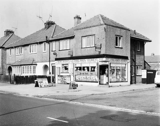
More traditionally known as Wynchlands, Winchlands Parade is the row of shops at Oaklands which arrived on the scene as a result of the opening up of the eastern borders of St Albans in the 1920s. Hill End Farm had been swallowed up by Hill End Mental Asylum in 1896, but surplus land from the farm came on the market in 1920 and plots were offered for sale along the southern side of Hatfield Road from the proximity of Ashley Road eastwards as far as the track to Butterwick Farm (adjacent to Homebase store).
Meanwhile, on the north side of Hatfield Road lay the diminutive Winches Farm – no more than three fields, a farm homestead and a couple of outbuildings. The background of these developments was the extension of the city boundary in 1913. Previously the city extended only to The Crown, but the new marker was pushed out as far as Winches (although I have never discovered the actual marker post it should be in the location marked with the red arrow on the annotated map above).


 |
| The above four images illustrate the Parade and semi-detached homes beyond, taken c2010. |
The Winches field adjacent to Hatfield Road – and next to the triangular entrance to the little farm – lay higher than the road, a topographical feature still visible today, where the shop fronts and pavement are at the front of the field level, the original slope towards the road now in the form of up to four steps – the parking bays at the lowest, adjacent to the road. Not that the bays are used as intended; vehicles are parked at right angles and with front or rear wheels at a higher level. When the Parade was still young and before the main road was fully made up at its current width, there was a strip of rough grass in front of the footpath.
The parade consists of twelve semi-detached buildings; most of the shops being at the west end with homes further east. The exception being the General Store on the eastern corner of Wynchlands Crescent. While the houses are strictly semi-detached properties with genuine spaces between them, the first six pairs are connected as if terraces, having enclosed and arched sideways between them, with the western side flats extending over the covered way.
Since twelve is a substantial number for purely local shops, would the parade have included a smattering of specialist retailers not found elsewhere in Fleetville? The answer to this question is rather more muddled than might be imagined for a newly completed estate. The 1930 Kelly's directory is the first to name the new coming occupants of the houses, and it is not until 1934 that the shop occupiers begin to trickle in and are named – and for many of the addresses no trade is added, perhaps indicating the properties began as residences. In fact, a butcher (399), an engineer (401), a tailor (413), a general store (417) and corner store (447) were the only shops identified before 1946. However, during the 1950s and 60s the choice for shoppers widened. In 1960 there was:
399 W Jones, butcher
401 H Cocks, engineer (changing to J Adams, fruiterer in 1966)
403 A greengrocer
405 E Adams, footwear
407 Oaklands Fisheries
409 Mrs Hemmingway, confectioner
411 Ladies hairdresser
413 Milliner and wools
415 Selina Gowns
417 Wine store
419 Upholstery, later Oaklands Electric
421 Oaklands Electric
447 Grocer
At the same time opposite the parade on the south side of the road was a house conversion (444) into a general store and sub-Post Office.
The parade therefore offered a wide range of merchandise, the clear omissions would have been an ironmonger, baker and a chemist, for which a longer walk or short bus ride to Fleetville would have been required.
.jpeg) |
| The western end of the Parade in 1964. The left house (after the former Bunch of Cherries PH sign) had been occupied by electrician Mr H G Cocks, who later moved his business to number 401, the building with the hipped roof. Mr Cocks's house has now been replaced by Glenbower Court. COURTESY ST ALBANS MUSEUMS |
.jpeg) |
| The basic bus stop of 1964 now has a shelter. It was also the period before the convenience of customer car parking. Potential customers were also welcomed by sun blinds. COURTESY ST ALBANS MUSEUMS |
 |
| At the end of the Parade and houses is the literal corner shop. All of the windows in 1964, including the smaller window probably part of the original domestic accommodation, were used for display. Today, the main windows are covered by enticing marketing for products sold inside and the forecourt is more cluttered than shown here. The posting box has now been moved from its 1964 location on the south side of the road where the sub-post office had been. COURTESY ST ALBANS MUSEUMS |
Today, numbers 419 and 421 are no longer shops, having been converted into residences, and most of the "useful locals" have disappeared altogether, those roles being maintained solely by Oaklands Stores at the eastern end. Even the former store and sub-post office is now converted into a branch of J J Burgess, Funeral Directors.
So, the recent line-up for the parade is Hair Extensions, a men's hairdresser, Plumbing & Bathrooms, a house agency, a fish & chip shop, a bargain shop, a recently closed blinds shop, a flooring supplier, an oriental takeaway and a wine shop. The parade is now supporting a considerably larger numbers of homes along Hatfield Road from Ryecroft Court to Wynches Farm Drive, Austen Way and Marconi Way. No wonder the car parks at larger more centralised stores are regularly busy.
Early photographs and recollections of the Parade and its environs would be especially welcome: saoee@me.com
Update 28 Aug 2022:
Boundary posts for the 1913 city extension are extant at Sandpit Lane (near Damson Way) and Hill End Lane (between Nightingale Lane and Frobisher Road), but it seems illogical that such a post would not have been fixed at the Hatfield Road location, this being where the boundary crosses by far the most important road leaving the district. It is therefore likely that one had existed but has since been removed. Does any reader have knowledge of a 1913 post here?
Above I have suggested that the Parade did not include an ironmonger's shop, but this seems not to be the case. A former resident from the early days of the Parade recalls the detached building (397), which was occupied by Mr Cocks – which Kelly's Directory refers to as "Engineer", in practice operated as an ironmonger's shop.
No comments:
Post a Comment