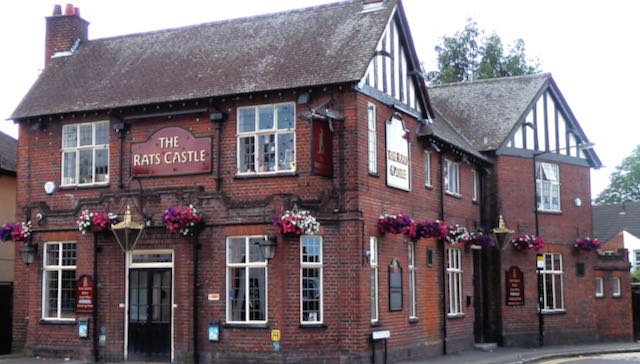
The first in our series of absent buildings which have left no known visual trace occupied a well-known plot in Fleetville. Mention the Rats' Castle to anyone who has ever lived in our around Fleetville and they will identify with the corner of Hatfield Road and Sutton Road. The Rats' Castle (inevitably printed without the apostrophe) public house has been a landmark here since 1927; and there is a reason why the building sits at this spot.
 |
| The latest of three buildings which have occupied this corner of Hatfield Road and Sutton Road. The Rats' Castle PH opened in 1927. |
If you compare Primrose Cottage and its shop with the later public house it is possible to spot similarities in some of the design elements. There is just one known image of Primrose Cottage and shop, but I wonder whether, during its thirty year life span other views existed – still exist.
Before either of the above buildings had existed a far more basic structure had been erected on the same footprint. Although there is no proof of the wall materials – probably brick – we do know from recorded recollections that the roof was thatched and that it was a "little square" in floor area. Its function was to house a turnpike toll collector (the road between Hatfield and St Albans was part of the Reading & Hatfield Turnpike Trust). The track beside the little building later became Sutton Road and was on the edge of Beaumonts Farm owned by Thomas Kinder who also happened to be a trustee of the Turnpike Trust. He gave the land on which the toll house was to be built and which enabled tolls to be collected before travellers set foot, wheel or hoof on the turnpike. The track belonged to Mr Kinder and so he had a double interest in benefiting financially. We know the toll house was erected before 1879 as the Ordnance Survey map of that year informs us, but the only known earlier record is the 1840 tithe map which is absent on the matter.Formally called the Hatfield Road toll house it was given up by the Turnpike Trust and continued to be occupied for a time before being abandoned by 1890. It became rat infested, the rodents making their homes in the straw roof. Passers by had already given it a nickname by the time of the 1891 census: "the rats' castle". The building was identified as such in the 1891 census, and the field in which it stood, previously known as Broad Field, was known as Rats' Castle Field. When in c1899 houses were built on part of the field the road was named Castle Road.While we have been able to build a story based on those facts available to us no-one has brought forward a photographic image or a reasonably accurate pencil drawing or water colour painting. We know where it was located from map evidence but we are badly in need of a photograph or drawing. Let's get searching.
For further details of the above buildings on this site:
http://stalbansowneastend.org.uk/topic-selection/rats-castle/


No comments:
Post a Comment