Sunday, 28 March 2021

Pub on the corner

 No prizes for guessing that the one we're talking about is the Rats' Castle.  Against the odds by a substantial number of property owners – though not necessarily their tenants – it received its licence in 1927, roughly 85 years after the first building which farmer and land owner Thomas Kinder allowed to be built on the edge of his farm.  Kinder was a trustee of the Reading and Hatfield (R&H) Turnpike Trust, of which Hatfield Road was part.  A number of road users discovered they could make use of the road without paying a toll by taking an alternative private track, now Sutton Road, without passing the toll house at the Peacock PH at the edge of the town in Hatfield Road.  Around 1840 Mr Kinder agreed with his fellow trustees to erect a simple toll house; a map shows it to have been a small cross plan rather like a four-bay barn form familiar to farm environments.  From observations made at the time it appears to have had a straw roof, and probably had a central fireplace with a chimney emerging from the highest part of the roof.

The road crossing the map between left and right is now Hatfield Road. The private farm track
leading to it is on the edge of Beaumonts Farm.  The pink cross-shaped building was the toll 
collecting building on the side road, which, today, is Sutton Road.  MP was the location of the mile
post halfway along where Bycullah Terrace would be built c1900.  A few years later the post was moved further west (so therefore not strictly accurately placed).  This map is from 1879.

As it was intended to catch toll evaders rather than regular traffic it is likely that the tollkeeper's presence was intermittent.  Further,  closure of toll charging was widely anticipated, possibly up to a decade in advance, and the R&H Trust was not known for its diligent  record keeping the toll house may have been empty for some time.  However, it was at least standing when a map in 1879 was issued.

By common knowledge the roof spaces were occupied by rats and by the 1880s the local landmark was commonly known as the Rats' Castle, and the field in which it stood was equally well known as Rats' Castle Field.

The enumerator's route description for the 1891 census.  In the centre of the red circle is the
name Rats' Castle (with a following apostrophe) identifying both the former toll house
and the corner of the field in which it had been built.

The old tollhouse had been demolished as soon as Mr T E Smith's nearby printing works arrived in 1897; an opportunity for Mr T Cooke to take advantage of the site for a house and shop, which was known as Primrose Cottage.  It is possible plans by Smith for shops opposite the works were unknown in the public realm, but Mr Cooke and then Mr Percy Stone both sold beer and spirits in addition to  stocking a range of grocery items.  Swiftly businesses and homes grew up in the Fleet Ville district; a number of their owners objected to the sale of alcohol.  In the case of spirits only large bottles could be purchased anyway, beyond the pockets of most residents but possibly not their landlords or employers!

Primrose Cottage shop when it was managed by Percy Hector Stone.  He would later move
across the road to trade from Bycullah Terrace.  This building had a short life of less than thirty years.
COURTESY ST ALBANS MUSEUMS

Two well-known businesses had already attempted to open hotels and public houses: Trust Houses and Benskins.  Animosities occasionally flared up between vested groups through to the 1920s.  Benskin's had a "Plan B"; it acquired the ownership of the corner shop because it had already secured its off-licence shop and spirits supplier from the previous occupant P Perkins, and installed its own tenant, C Griffin and then George Hopkins.

Finally, Benskin's received its full on-licence in its own right, and engaged local architect, Percival Blow to design the new building, the frontage having distinct echoes of Primrose Cottage and shop.

The 1920s public house which replaced both the toll house and Primrose Cottage.
Somewhere on the site there will probably still be evidence of a well.  Architect: Percival Blow.

"The Rats" as it became known to regulars, has never been short of clientele.  Benskins at one point during the 1970s decided that the rodent might put off possible customers, and an adapted hanging sign  went on display with the name The Castle.  The new name did not last long, thanks to some sterling defence by regular customers, and even Fleetville residents who would not normally take up such a cause.  Within a few months the traditional title returned.

The short-lived hanging sign for The Castle –
without a rat in sight!


But one aspect of the sign never wavered; the artists, presumably under company instructions, have never included an apostrophe, when a following apostrophe would be expected by default, a singular rat not being sufficient to sustain a population of the rodents to maintain the story, which may remain unique in the UK – but it would be great to have this confirmed.

If the Rats' Castle is on one corner of Sutton Road we might think Ballito was on the other.  Next time we will discover whether that was true.

Wednesday, 10 March 2021

The Bakery and More

The development land between Sutton Road and the Ashpath became available from 1899, as we discovered in the last blog.  To be specific, until then it had been arable, bordering the south side of Hatfield Road.  According to the 1841 tithe survey its traditional name was Broad Field, but by the last decade the space was locally referred to as Rats' Castle Field and was named so on the 1891 census.  More of that in the next post.

This map was surveyed in 1922.  The blue shape is the former Primrose Cottage.  Orange marks
the land occupied by the Co-operative Bakery, and the green circle shows the approximate position of the tree in the photo below.
COURTESY NATIONAL LIBRARY OF SCOTLAND


The righthand most house is Charles Tuck's house, though it is in deep shadow in this picture.  The tree further along the road is shown as a green circle in the above map.
COURTESY HALS

     So how come the first two plots to be built on were at the Far Eastern end (Symons Laundry and house, and Tuck's house right in the middle?  If I chose from a box of chocolates that were all the same, it wouldn't make any difference whether I selected from a corner, the bottom row or in the middle.  So if the plots were the same size would it be any different? 

A late 1930s picture taken outside Tuck's workshop and house looking towards Ballito Hosiery Mill. 
The laundry building is opposite.
COURTESY THE JANET STALEY-HAINES COLLECTION

Nevertheless, Charles Tuck chose his plot and while not dead centre, there was plenty of empty ground on either side. He wasted no time in having his family house put up, with space for his workshop to the left of the house.  And because neither is there today we should mark its former location; there is a block of flats with the exterior walls painted cream (to the right of the flats painted blue). Tuck's house is the left half of the cream flats.

Charles and Louisa were settled in their new home with a bicycle and motor vehicle repair workshop up and running as Fleetville itself grew, and we was able to dispense fuel for motor cars via a pump which went over the pavement.  Charles was a keen footballer and took responsibility for managing at least two community teams in the district, one based on young men living in groups of Fleetville streets; the other members of the Adult Schools in Stanhope Road.  The family were members of the Hatfield Road Methodist congregation.

The Co-operative Bakery, followed by Tuck's, in a photo taken in 1964.
COURTESY ST ALBANS MUSEUMS

Before moving on, I mentioned the blue flats above.  Until around 1914 the land to the left of Charles Tuck was vacant but the St Albans Co-operative Society purchased the block between Hatfield and Castle roads and built itself a bakery, retailing the bread in all of its stores.  Following an overnight fire in 1954 the bakery was closed but the site retained and subsequently used as a petrol filling station.  Therein lies the story of today's blue flats!

Today's view of the previous photograph.
COURTESY GOOGLE STREET VIEW

Five years after the Tuck family moved into their new home builder William Bastin moved into his three plots.  Let's be clear, because he was a builder, he built a house to live in and run his business.  This has now been replaced by the right half of the cream flats.  

You will note a driveway leading to what was Bastin's work yard, and which connected directly to plots in Castle Road; Mr Bastin also built those – 29 to 41.  To the right of the driveway in Hatfield Road is a semi-detached pair; Mr Bastin built that too, but in 1938 both were converted to shops with flats upstairs.  Number 258 was a baker's and caterer's, although it succumbed to the post-war betting craze as a Ladbroke's.  Number 256 became the Woolpack Boot Repairs, renamed Fleetville Shoe Repairs after World War Two.  There will be a few residents who recall the animatronic model of a traditional cobbler endlessly banging hobnails into a little boot. Today the premises is an Indian Takeaway named Shaad.

The four shops between Bastin's driveway and the semi-detached pair just before the Rats' Castle. 
Photograph taken c2012

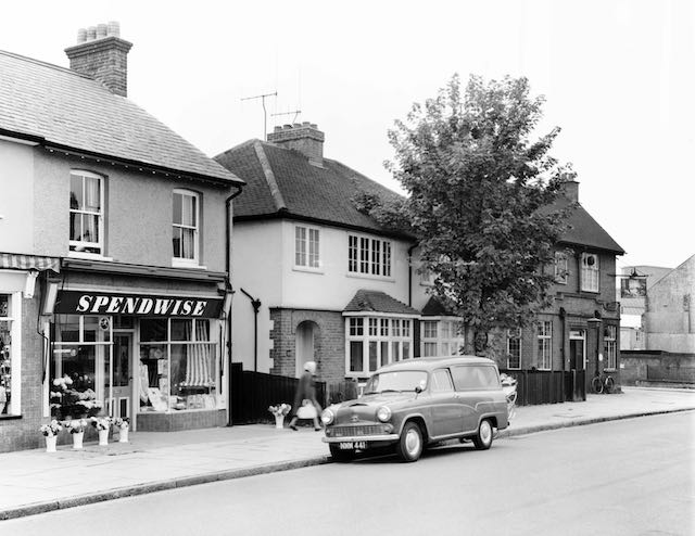
Two more shops were added to this little row, one filling in a gap, having been acquired in the name of Mrs Bastin. But that did not arrive on the scene until just before World War Two; until then the weeds continued to grow. Long before then Mr and Mrs Hill chose a plot with unoccupied ground on both sides.  Perhaps the Hills felt by 1938 this part of the street was becoming a little crowded, so they moved; the result being the downstairs was converted into a shop.  Early residents of Fleetville will have remembered the Needlecraft and Wool Shop (Mrs Bastin's); the other called Spendwise.  The latter began as a greengrocer, although there were eventually plenty of greengrocers in Fleetville.  So Spendwise then specialised in floristry.  Today 254 and 252 are an Indian restaurant and The Lantern House Chinese Takeaway.

The righthand most shop when it was Spendwise florist in 1964, followed by a semi-detached pair.
Finally is the Rats' Castle public house.
COURTESY ST ALBANS MUSEUMS

Perhaps it was the arrival of the next properties which had finally encouraged the Hills to move, for Emily Lindley, from Salisbury Avenue, purchased the remaining double plot just as the Primrose Cottage next door was to be rebuilt as a public house.  250 and 248 have remained as built, as a low-height semi-detached pair.

The City Council, now greatly more empowered by planning regulations, drew a line, both here and on the north side; this is where retail in Fleetville should stop.

For readers who feel the Rats' Castle has been rather casually omitted, the public house is far too significant and receives its own post next time.


Tuesday, 2 March 2021

A Look at the South Side

 During the latter part of 2020 our posts explored the north side of Hatfield Road, and during that time we covered the distance from Clarence Road to Beaumont Avenue.  Now it is time to turn our attention to the south side of the road, beginning from Ashley Road, thus returning to where we began.

Tree-lined Hatfield Road looking westwards towards The Avenue (Beaumont Avenue).  
This is when we were "out in the country" and we were able to launder in the middle of the road.
COURTESY ST ALBANS LIBRARIES (HALS)


The countryside continued, along the tree-line Avenue towards Beaumonts Farm.


While building was taking place for the printing factory and the Fleet Ville, we would have crossed the boundary into Beaumonts Farm.  If we had ventured further east along the road towards Hatfield our way would have taken us through the quiet of the countryside, for in 1898 there was no building after passing the Rats' Castle toll house which was being prepared for an enterprising build called Primrose Cottage.  We would have passed those Beaumonts Farm fields on both sides, probably not in the best of cropping condition as in the following year they would also be prepared for development.  Individual field and hedgerow trees were being sold as standing timber, as evidenced by little adverts in the Herts Advertiser.  Beyond The Avenue a continuous line of boundary trees stretched all the way to Harpsfield with few breaks along the way.  We were well into the rural tranche for which Primrose Cottage became appropriately named.

A board was erected at the end of The Avenue indicated an amount of land for sale.  One block to the west of The Avenue as far as the foot of the hill; another block bounded by the Ashpath track, Camp Lane, the track later known as Sutton Road, and the branch railway; and finally, a narrower rectangular block between the railway and the road to Hatfield.

This last block was purchased by the development business of T R Marriott of North Walsham, Norfolk – who also acquired a large tranche of the Salisbury Avenue block, along with Alfred Nicholson. A number of single plots were sold for building by Marriott's, but small groups of plots were also transferred to Charles Blow, David Massey and William Bastin.

Unfortunately I have not seen any photos of the Ash Path, its junction with Hatfield Road or its approach towards the railway bridge shortly below the bottom edge of this map.  This is the 1924
OS map shortly before a number of houses which will occupy the two square sections of the field
above.
COURTESY NATIONAL LIBRARY OF SCOTLAND


The aerial photo above  shows Hatfield Road across the lower half of the view, with Castle Road
across the top half.  Ashley Road is on the extreme left.  When the Ashley Church later arrived it
was able to tidy the angled corner on the left; it made use of the former Handalone Laundry
which Mrs Symons' business used before she and her family  migrated to 
Australia c1930.
COURTESY GOOGLE EARTH

The private road and farm track which would shortly be known as The Avenue (then Beaumont Avenue) was continued on the south side of the road to Hatfield.  This was effectively a crossroads within a farm.  On all four quadrants was Kinder-owned farm land, and the track on the south side leading to Hill End, which the newly opened Owen brickworks had gradually given a new name from the patches of ash and cinders used to improve its surface – the Ash Path or Cinder Track.  This was a permissive path used to enable public access to Hill End and it was inevitable it would become a future road.

For the first few years of the 20th century nothing much happened; there was no rush to build.  In fact just one property went up immediately, which will be described in more detail in the next post.

Ryegate, 282, the first house to be erected c1906, although the OS map appears to show the
house as a semi-detached pair.

The second property, a house given the name Ryegate (today's 282), was first occupied by Arthur Nightingale in 1906.  A further two years passed before a further house near the Ashpath corner quickly became Mrs Symons Handalone Laundry.  

The field remained quiet again until c1912 when a group of houses next to Mr Nightingale was put up, and gradually the rest of the spare plots were occupied between the end of World War One and 1926.  We should also bear in mind that the gardens behind these homes met gardens which fronted onto Castle Road.

We discover from the 1911 census and 1939 registration something of the occupations of the people living in the homes between 268 and 314 Hatfield Road.  Many were employees of railway companies or local printing works; and inevitably, given buildings were springing up widely, there were occupations related to the building sector.

For the most part this row of varied houses has remained unremarkable during the past century, not because they have not deserved to be otherwise, but because until we reach nearer the Rats' Castle PH, there has been less variety in the land use; and the Editor has to admit he knew no-one who lived in any of those houses during the period in which he was growing up!

In the next post we will pass bread, tyres, flowers and a drink or two.