The development land between Sutton Road and the Ashpath became available from 1899, as we discovered in the last blog. To be specific, until then it had been arable, bordering the south side of Hatfield Road. According to the 1841 tithe survey its traditional name was Broad Field, but by the last decade the space was locally referred to as Rats' Castle Field and was named so on the 1891 census. More of that in the next post.
 |
| The righthand most house is Charles Tuck's house, though it is in deep shadow in this picture. The tree further along the road is shown as a green circle in the above map. COURTESY HALS |
 |
| A late 1930s picture taken outside Tuck's workshop and house looking towards Ballito Hosiery Mill. The laundry building is opposite. COURTESY THE JANET STALEY-HAINES COLLECTION |
Nevertheless, Charles Tuck chose his plot and while not dead centre, there was plenty of empty ground on either side. He wasted no time in having his family house put up, with space for his workshop to the left of the house. And because neither is there today we should mark its former location; there is a block of flats with the exterior walls painted cream (to the right of the flats painted blue). Tuck's house is the left half of the cream flats.
Charles and Louisa were settled in their new home with a bicycle and motor vehicle repair workshop up and running as Fleetville itself grew, and we was able to dispense fuel for motor cars via a pump which went over the pavement. Charles was a keen footballer and took responsibility for managing at least two community teams in the district, one based on young men living in groups of Fleetville streets; the other members of the Adult Schools in Stanhope Road. The family were members of the Hatfield Road Methodist congregation.
 |
| The Co-operative Bakery, followed by Tuck's, in a photo taken in 1964. COURTESY ST ALBANS MUSEUMS |
Before moving on, I mentioned the blue flats above. Until around 1914 the land to the left of Charles Tuck was vacant but the St Albans Co-operative Society purchased the block between Hatfield and Castle roads and built itself a bakery, retailing the bread in all of its stores. Following an overnight fire in 1954 the bakery was closed but the site retained and subsequently used as a petrol filling station. Therein lies the story of today's blue flats!
 |
| Today's view of the previous photograph. COURTESY GOOGLE STREET VIEW |
You will note a driveway leading to what was Bastin's work yard, and which connected directly to plots in Castle Road; Mr Bastin also built those – 29 to 41. To the right of the driveway in Hatfield Road is a semi-detached pair; Mr Bastin built that too, but in 1938 both were converted to shops with flats upstairs. Number 258 was a baker's and caterer's, although it succumbed to the post-war betting craze as a Ladbroke's. Number 256 became the Woolpack Boot Repairs, renamed Fleetville Shoe Repairs after World War Two. There will be a few residents who recall the animatronic model of a traditional cobbler endlessly banging hobnails into a little boot. Today the premises is an Indian Takeaway named Shaad.
 |
| The four shops between Bastin's driveway and the semi-detached pair just before the Rats' Castle. Photograph taken c2012 |
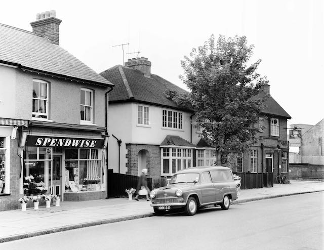
Two more shops were added to this little row, one filling in a gap, having been acquired in the name of Mrs Bastin. But that did not arrive on the scene until just before World War Two; until then the weeds continued to grow. Long before then Mr and Mrs Hill chose a plot with unoccupied ground on both sides. Perhaps the Hills felt by 1938 this part of the street was becoming a little crowded, so they moved; the result being the downstairs was converted into a shop. Early residents of Fleetville will have remembered the Needlecraft and Wool Shop (Mrs Bastin's); the other called Spendwise. The latter began as a greengrocer, although there were eventually plenty of greengrocers in Fleetville. So Spendwise then specialised in floristry. Today 254 and 252 are an Indian restaurant and The Lantern House Chinese Takeaway.
 |
| The righthand most shop when it was Spendwise florist in 1964, followed by a semi-detached pair. Finally is the Rats' Castle public house. COURTESY ST ALBANS MUSEUMS |
Perhaps it was the arrival of the next properties which had finally encouraged the Hills to move, for Emily Lindley, from Salisbury Avenue, purchased the remaining double plot just as the Primrose Cottage next door was to be rebuilt as a public house. 250 and 248 have remained as built, as a low-height semi-detached pair.
The City Council, now greatly more empowered by planning regulations, drew a line, both here and on the north side; this is where retail in Fleetville should stop.
For readers who feel the Rats' Castle has been rather casually omitted, the public house is far too significant and receives its own post next time.


No comments:
Post a Comment