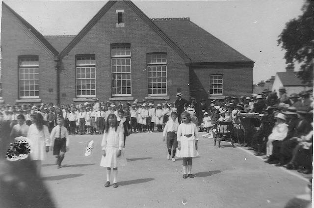
The previous post described how, in able to find space for a new school in 1938, proposed homes were scrubbed from the developer plans. It seems this was not unique hereabouts. Roll the calendar back thirty years along Tess Road (now Woodstock Road South) and Royal Road, and the house building scheme for the space between those two roads had just begun, when a lethargic education authority jumped to life and responded to residents' complains that there was no school in Fleetville for their children. A public meeting was held in a room at the Fleetville Institute on the corner of Arthur Road and the parents pressed their case successfully. The St Peter's Rural School (Camp) coped inadequately for the new Fleetville district as well as serving Camp and Tyttenhanger et al. Stung by the pressure, the education body ensured no more houses were added to Tess Road and work began on building a new school – well, part of one.
 |
| Fleetville Elementary Schools – which for four years 1908 to 1912 accommodated children from 5 to 13 years old. The view is from Royal Road. |
The three houses at the south end of Tess Road just about pre-dated the schools, and were immediately transformed into the district's police station, and would much, much later offer essential school space in a further burgeoning accommodation crisis. Keep an eye, too, on the outside toilets next to Tess Road. They began as equal spaces for boys and girls, although later extended to match increased numbers, especially for infants.
The next available map was published in 1937. So this is the first opportunity for proving the existence of the smaller infant building – it had only been there for 25 years! 1937 was also the year when work began to expand the infants accommodation: a wooden hutted building raised off the playground and with steps to each of the two classrooms. To view this building we need to fast-forward to the next available map in 1963. I have not been able to find a single photograph of "The Huts", and by the time it appeared on the 1963 map plans were afoot to construct a permanent hall building in its place.
Look across Royal Road to the recreation field, much used by the older children. This map was published too early to show the temporary nursery building which arrived in 1942, but we do find proof that the field was then surrounded by metal railings with recognised gates. Generations of children had worn a path from Hatfield Road towards the school entrance, officially Royal Road, via recognised gates.
One other restrained feature on the 1937 map is a short double line on the top left of the main building; our only clue to the basement boiler heating room at the foot of a flight of stairs. It also performed a role as store room.
 |
| The start of greening the playground spaces. The wall to the right is what remains of the former outside toilets which were in use for all children for sixty years. |
1963 reveals that the space between the main building and infants building has been filled in, providing important additional accommodation, including toilets and offices. The outline shape at the north end was also different, providing toilets and an additional classroom. The work removed evidence of wartime blast walls at the main entrances of both buildings, and therefore not shown on any map. Also appearing for the first time – although probably present for nearly fifty years – is a small wooden structure used as a cycle shed.
The 1963 map is also the first to show the 1942 nursery building, although does not include evidence of the ramps leading down to the wartime tunnels under the nursery and beyond into the field. Maps are sometimes poor recorders of landscape changes!
The eighties see the infants section take over the entire building; the juniors moving across Hatfield Road to a nearby empty school building. But that hasn't been the only move; the seniors from elementary school days finally left just in time to become part of the new Beaumont Schools in 1938. Just as well, for in 1940 evacuee children from Princess Road School, Camden (now Primrose Hill Primary) arrived to share the buildings, thus creating one of Fleetville's periodic bulges, the next one lasting through the 1950s until 1980 even though a whole new school (Oakwood JMI) had opened from 1959 specifically to counter overcrowding at Fleetville.
 |
| Google's flyover photo today reveals both a familiar layout and a fuller one, especially in the use of the outdoor spaces. COURTESY GOOGLE EARTH |
 |
| COURTESY GOOGLE EARTH |


1 comment:
Mike, really interesting post about my old school... I started Infants in 1971 and the wooden hut building was still being used then... The juniors moved to the old Sandfield Girls school in September 1975...
The old Police house was still used as a classroom until July 1975... I remember the link between the two parts of the building being used for delivery of children's milk and then the school dinners...
Post a Comment