Wednesday, 7 August 2024

By-Pass It

 Until the 1920s the road network between London Colney and St Albans was straightforward: High Street in the village connected with London Road and High Street in the city; Shenley Lane in the village connected with Napsbury Lane and then the ancient road from London towards St Albans; the old road between the village and Cell Barnes Lane (Alexander Road and Nightingale Lane) took a rather different route to the city's market centre via Cell Barnes and Victoria Street. Finally, a link was available from High Street via White Horse Lane to Tyttenhanger Green and Camp.  This last route was still possible while the St Albans Bypass was still a single carriageway.

Working on the St Albans Bypass North Orbital in the 1920s.  The land purchased was sufficient
for twin 3-lane carriageways plus additional space for cables, pipes and space between the
carriageways.  Only one carriageway was completed.
COURTESY THE HERTS ADVERTISER

A post-WW1 national roadbuilding programme included a bypass around St Albans between Hatfield and Watford – a section of the North Orbital Road – squeezing through the gap between Cotlandswick and Newhouse Park Farm.  This fresh west-east barrier between London Colney and St Albans remained a single carriageway until the 1950s, but it did include a roundabout linking the village High Street with London Road.  A "square-about" would be a more appropriate label and was located a little west of the present maze of traffic lights.  Elements of the square-about can still be detected by the roadside.

The first roundabout which separated London Colney's High Street and London Road, the main A6
road before the London Colney Bypass was built.  The abbreviation TCB (circled) was the
location of a telephone call box.
COURTESY NATIONAL LIBRARY OF SCOTLAND

At the bypass end of the stopped up High Street remain the connections for the former telephone
call box which served this important road junction.  The just-visible overbridge marks
the location of the original roundabout (sometimes known as a square-about).

The often-related account of the capture of a German spy at this junction in 1940 still retains its location evidence; the former telephone kiosk used by the spy, an off-duty soldier and a police officer from the former Fleetville police station where a telegraph post and a pavement connection box remain in place at the bypass end of the former stopped-up High Street.

To pass along Shenley Lane and Napsbury Lane across the first iteration of the bypass was on the flat, which was fine in its early days, but to herald the major widening works in the 1950s a new bridge was constructed over the approaching dual carriageway.

Photograph taken on the Shenley Lane over bridge looking towards London Colney roundabout,
as the second carriageway was opened in 1956.
COURTESY THE HERTS ADVERTISER


Shenley Road over bridge completed in advance of the new carriageway and which replaced
the original surface junction.

Compare the sparse traffic level of 1956 photograph with a 2014 view of the London Colney
roundabout before the present addition of further traffic signals and their re-phasing.


A significantly larger roundabout was also required for the next stage of the project, and the imminent inclusion of the three-mile London Colney Bypass.  This shaped relocation required the diversion of a small length of London Road between Birklands and Nightingale Lane.  Houses already built became satisfyingly marooned in their own backwater, although those in Nightingale Lane were less fortunate, being closer to the incessant streams of roundabout traffic.

In or around 1920 the Electrical Apparatus Company (EAC) opened one of its four works buildings (the others being at Walthamstow, Wandsworth and Vauxhall) between Birklands and the Midland Mainline Railway.  Small farms are vulnerable when modern infrastructure and expansive developments nibble at the edges or slice through the heart of a farm.

The "square-about", and to the left the surface junction of Shenley Lane and Napsbury Lane.

By 1954 Newhouse Park Farm effectively ceased to operate, having earlier relinquished land for the factory and housing, and now transferring still more to the Ministry of Transport for road construction.  EAC acquire 37 further acres for its staff playing fields.  The farm homestead, outbuildings and a home field became the property of Albert E Bygrave, and in 1959 he opened his nursery fronting the bypass.

Yes, these houses are in London Road.  The road led to London Colney High Street. The original
"square-about" was out of sight at the end of this view.

However, the youthful entrepreneur Roger Aylett entered the horticultural marketplace a full four years earlier, having completed his horticultural qualifications at Oaklands Agricultural Institute (now Oaklands College).  He acquired through his parents a seven acre segment of land surplus to EAC's recent acquisition.

Roger Aylett's parcel of land lay between the houses on the north side of Napsbury Lane and the remainder of the former Newhouse Park Farm homestead.  He benefited from a lengthy frontage to the bypass and its newly fenced off works being prepared for the second carriageway.  Aylett may not have realised it at the time but his frontage opening along a busy road and a second minor access from Napsbury Lane, offered his business a splendid kerbside vista, which Bygrave used to good effect as a location marker – "adjacent to Aylett's"!  A dual carriageway might have resulted in awkward access for his customers, but in the case of Aylett's the large nearby  roundabout on one side and an over bridge on the other ensured convenient access when entering and leaving his site.


Map and aerial photograph providing an overview of the topic. London Colney is to the
bottom right; London Road leading to St Albans to the top of the image.
COURTESY OPEN STREET MAP CONTRIBUTORS
COURTESY GOOGLE EARTH
Driving or riding on a bus between London Colney and St Albans via the roundabout was one thing, but if you wish to cycle or even walk the bypass makes life difficult since it was necessary to carriageway-hop – until it became essential to respond to the accident rate and provide a scaffolding bridge on the site of the former square-about.  This bridge was later replaced by a more elegant structure, which is still in use today.

Meanwhile, the round roundabout became larger and collected even more traffic signals!


Tuesday, 30 July 2024

Nicky is Sixty Plus

 If you were reading the Herts Advertiser last week you will already be aware that one of our secondary schools celebrated its sixtieth birthday.  Nicholas Breakspear Secondary is the school, but its birthday is only that of the current suite of buildings in Colney Heath Lane, just on the south side of the railway bridge over the former branch railway (now Alban Way).

The land had previously been reserved for a  partner establishment to Hill End Hospital.  However the size of the site was discovered to insufficiently large for that purpose and the partner hospital became Cell Barnes, after the nearby lane, in 1930.  It no longer exists but part of Highfield has been built on its former site.  For a short while in the 1950s the Colney Heath Lane land was used for playing fields for St Albans College of Further Education, before moving to Smallford but a parcel of land is still retained by Oaklands College.

The story began here: at 148 London Road, just uphill from the current Odyssey Cinema.


Rooms at the back of the SS Alban & Stephen church in Beaconsfield Road were organised
into a full-time school...

...but external rooms were brought into use at the now-demolished Adult School
in Stanhope Road as pupil numbers increased further.

A purpose designed school opened in Vanda Crescent with separate sections for infants, 
juniors and seniors, creating an elementary school.

In the 1950s the secondary pupils found a larger site at Garston which we have always known as
St Michael's Catholic High School.

...and in the mid sixties a whole-school's-worth of secondary pupils found their present home
under the banner of Nicholas Breakspear Catholic School in Colney Heath Lane.  It has been
some journey!

But to discover the true origin of the Catholic Secondary School we need to travel much further back in time.  A Catholic denomination church was established on the south side of London Road in 1878, and educational provision was undoubtedly offered on a limited scale, but for worship and educational purposes a new church centre was opened in Beaconsfield Road,  a number of rooms at the rear of the site being used as a school, unfortunately rather close to the busy railway at the Midland City Station.

The school in this building remained here until 1935, although some of its classes also occupied external rooms, including in the Adult Schools building in Stanhope Road. The Ss Alban & Stephen School as an  organisation was  formalised on Elementary principles, just as the rest of the educational service had begun to separate into separate primary (infant and junior) and secondary establishments.  The new elementary school was achieved by the acquisition of Friederick Sander's private garden in Camp Road when this was sold by his sons in the 1920s after their father's death.  A purpose designed single storey set of buildings was created and was opened with separate infant, junior and secondary wings in Vanda Crescent.

Although plans were made in the 1950s for two outreach schools at Marshalswick and St Julians the development of these two units was much delayed.

The opportunity arose in 1955 for the secondary unit at Vanda Crescent to become a larger junior space.  A new Catholic secondary school was opened at Garston under the name St Michael's in High Elms Lane.  The SsA&S secondary pupils transferred to Garston, enabling a more mature secondary curriculum to be offered.  However, within three years St Michael's became full, and expansion came with the provision of a Catholic secondary school specifically for St Albans.

The new 3-form entry school opened on the Colney Heath Lane site under the name Nicholas Breakspear Catholic Secondary School.  Occupying the 31 acres previously deemed not sufficient for a hospital the site has now settled for the longest period in its history, so this is an additional reason for celebrating the anniversary.

For further information St Nicholas Catholic Church is located in Watling Street and St Adrian's JMI school in nearby Watling View opening in 1960, just ahead of Nicholas Breakspear School.

Of course, the structures of school buildings from the post-war period, were not expected to last for an endless period; nor were they expected to be efficient to maintain.  The school is therefore planning ahead for a future with new buildings.  And who knows what NBS will look like in three or four years time.

Monday, 15 July 2024

More of the Same

 The previous post described how, in able to find space for a new school in 1938, proposed homes were scrubbed from the developer plans.  It seems this was not unique hereabouts.  Roll the calendar back thirty years along Tess Road (now Woodstock Road South) and Royal Road, and the house building scheme for the space between those two roads had just begun, when a lethargic education authority jumped to life and responded to residents' complains that there was no school in Fleetville for their children. A public meeting was held in a room at the Fleetville Institute on the corner of Arthur Road and the parents pressed their case successfully. The St Peter's Rural School (Camp) coped inadequately for the new Fleetville district as well as serving Camp and Tyttenhanger et al.  Stung by the pressure, the education body ensured no more houses were added to Tess Road and work began on building a new school – well, part of one.

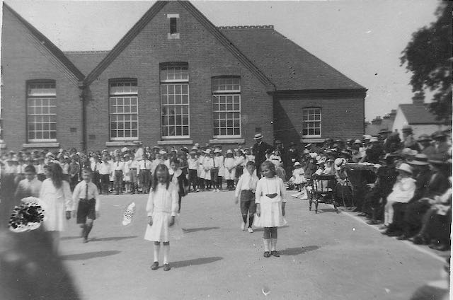
Fleetville Elementary Schools – which for four years 1908 to 1912 accommodated children from
5 to 13 years old.  The view is from Royal Road.


A revision of the 1897 OS map and published in 1912.  The intended division of the building into
separate girls & infants, and boys sections.  The empty block to the south is reserved for an
infants only building, opened in 1912 but after the survey preparation for this map.
Incidentally, ignore the Benskins reference; that links to the green site just visible on the left.
COURTESY HERTFORDSHIRE ARCHIVES & LOCAL STUDIES


On a new estate with young families you would usually begin with an infants wing, or today, a nursery with infants wing.  But families in Fleetville had been waiting for so long the need was evident in all age groups.  Work began in 1907 on the Juniors and Seniors building.  You will notice a line delineates the playground, and therefore the classroom accommodation, for boys separately from girls.  South of this the map identifies an empty plot, which four years later would include an infants building.  The map is unusual in being a re-survey required because of the pace of new building in the district.  Published in 1912 it was not, however, late enough for the new infants building, opened in the same year.  Until then infant children were crammed into the existing building with two classes using the hall.  Fleetville was therefore over-full at birth!

The three houses at the south end of Tess Road just about pre-dated the schools, and were immediately transformed into the district's police station, and would much, much later offer essential school space in a further burgeoning accommodation crisis.  Keep an eye, too, on the outside toilets next to Tess Road. They began as equal spaces for boys and girls, although later extended to match increased numbers, especially for infants.  

The school's north end in the 1930s.  The "boys'" playground was used for major demonstration
events.  Today, a 1960s extension has been added to the original building.
COURTESY FLEETVILLE INFANTS & NURSERY SCHOOL

The 1937 map finally shows the infants building (below the word Schools), although today
the space between has been closed in with a 1960s link building.  The houses on the west
side of Tess Road are in use as a police station and staff accommodation.
COURTESY HERTFORDSHIRE ARCHIVES & LOCAL STUDIES

The next available map was published in 1937.  So this is the first opportunity for proving the existence of the smaller infant building – it had only been there for 25 years!  1937 was also the year when work began to expand the infants accommodation: a wooden hutted building raised off the playground and with steps to each of the two classrooms. To view this building we need to fast-forward to the next available map in 1963.  I have not been able to find a single photograph of "The Huts", and by the time it appeared on the 1963 map plans were afoot to construct a permanent hall building in its place.

Look across Royal Road to the recreation field, much used by the older children.  This map was published too early to show the temporary nursery building which arrived in 1942, but we do find proof that the field was then surrounded by metal railings with recognised gates.  Generations of children had worn a path from Hatfield Road towards the school entrance, officially Royal Road, via recognised gates.

One other restrained feature on the 1937 map is a short double line on the top left of the main building; our only clue to the basement boiler heating room at the foot of a flight of stairs.  It also performed a role as store room.

By the 1960s extensions have created a rather different outline shape to
the building.  The smaller building just to the left of the word "South" 
is the timber building known as "The Huts" which arrived in 1937 and
would soon be replaced by a permanent hall structure.  The 1942 wartime
day nursery appears on a map for the first time.
COURTESY HERTFORDSHIRE ARCHIVES & LOCAL STUDIES


The start of greening the playground spaces. The wall to the right is what remains of the former
outside toilets which were in use for all children for sixty years.

1963 reveals that the space between the main building and infants building has been filled in, providing important additional accommodation, including toilets and offices.  The outline shape at the north end was also different, providing toilets and an additional classroom.  The work removed evidence of wartime blast walls at the main entrances of both buildings, and therefore not shown on any map.  Also appearing for the first time – although probably present for nearly fifty years – is a small wooden structure used as a cycle shed.

The 1963 map is also the first to show the 1942 nursery building, although does not include evidence of the ramps leading down to the wartime tunnels under the nursery and beyond into the field.  Maps are sometimes poor recorders of  landscape changes!

The eighties see the infants section take over the entire building; the juniors moving across Hatfield Road to a nearby empty school building.  But that hasn't been the only move; the seniors from elementary school days finally left just in time to become part of the new Beaumont Schools in 1938.  Just as well, for in 1940 evacuee children from Princess Road School, Camden (now Primrose Hill Primary) arrived to share the buildings, thus creating one of Fleetville's periodic bulges, the next one lasting through the 1950s until 1980 even though a whole new school (Oakwood JMI) had opened from 1959 specifically to counter overcrowding at Fleetville.

The former day nursery has been a community centre since the 1980s; the nursery
then moved to the garden plot of the former police houses, and its car park was
created where the police houses themselves once stood.
COURTESY OPEN STREET MAP CONTRIBUTORS

Google's flyover photo today reveals both a familiar layout and a fuller
one, especially in the use of the outdoor spaces.
COURTESY GOOGLE EARTH

To bring us up to date in the absence of intermediate maps, Open Street Map informs us that the former day nursery moved from its temporary location on the recreation field to where the garden for the former police houses had existed, and an expanded hall building dominates the Woodstock Road South side of the site.  If you were to walk along this road you will discover the former wall of the outside lavatories still in place!  And what of the former police houses?  They are now razed in favour of a car park for the Nursery building.  The modern map gives no clue to the busy-ness of the playground spaces, which encourages creative play instead of simply running around; and is a combination of grassed and shaded zones.

COURTESY GOOGLE EARTH

Much change has been packed into the past 116 years at the busy school in the busiest of districts in the city.


Thursday, 4 July 2024

Making Something Fit

 The need for new schools, especially senior establishments, forced Hertfordshire Education Authority to search diligently for appropriate sites, often catching up with builders and developers forging ahead with their housing estates.  Equally, the authority, was playing catch-up with government's regular changes of requirement and its own decisions to improve building and facility standards.

This week we ask the question why the students of Verulam School continue, after 86 years, 
 to walk to their games lessons between Brampton Road and Sandpit Lane.  Here
is the imposing school building when first opened in 1938 – although not visible until
reaching the inner end of the school drive.
COURTESY HERTS ADVERTISER

These playing fields, now adjacent to Oaklands Grange, at the eastern end of Sandpit Lane, was
originally purchased in the 1930s for the future senior school for Marshalswick.  Minds were
changed when the Education Authority realised it had purchased a site at Brampton Road which
was too small for the school it wished to build.
COURTESY GOOGLE EARTH

This all leads to the question of why, since 1938, the pupils of Verulam School, have walked their way to the eastern end of Sandpit Lane for their sport zone (games field).  Why did the Education Authority not incorporate the buildings and the games field on one site?  Good question.  The short answer is the sudden requirement for all areas to create new grammar schools if no alternative buildings were available, and in St Albans, there were was only one; the Central Girls School, opened only in 1931.  The plan was to create a  grammar school for girls on a new site and convert the Central School for a boys' grammar school.

Negotiations between the Authority and Earl Spencer, to acquire a portion of his new development between Brampton Road and Jennings Road, which was already under construction, managed to shoe-horn sufficient space for a new school between Park Avenue and Hamilton Road.  Unfortunately most houses in both of those roads were already completed and occupied.  Similarly, Brampton Road homes were largely occupied, except for the space opposite Sandfield Road.  The reason for such a space by the mid thirties is thought to be a new road linking Brampton Road and Churchill Road intended to connect Hatfield Road and Sandpit Lane.  This aborted section of the Spencer development, intended to assist with the Authority's purchase also prepared the way for the new school's entrance location.


Brampton Road running left to right in 1924, near the bottom edge. Clarence Road is partly
developed on the left, the gardens of Woodstock Road are on the right, and Jennings Road is
only partly laid out.  In this large space Park Avenue, Hamilton Road and the school would
find their spaces.  Had it not have been for the school another road linking Sandfield Road and
Churchill Road would have been driven through this space.
COURTESY NATIONAL LIBRARY OF SCOTLAND


In 1939 the School is one year old and new homes have enveloped its grounds.  Its front
drive opposite the end of Sandfield Road is the only part of the road which never was which
still exists. This was the school which was, together with tennis courts, how the school was
intended.  The Authority acquired the site to the right of the drive as the school's caretaker
accommodation.
COURTESY NATIONAL LIBRARY OF SCOTLAND

The space available for the proposed school was further restricted by the lengths of the rear gardens in the three roads, though not the south side of Jennings Road where housebuilding had not begun.  So, under the circumstances quite limited, but under the authorised layout requirements for schools it was sufficient for a girls' grammar school, and so the plans were drawn up.  In the meantime the Authority bean-counters suddenly realised the existing Central school in Hatfield Road was already a girls' school with accommodation for girls' facilities.  Rather late in the day, Central became the new Grammar School and the boys were provided with the new buildings in Brampton Road.

By 1963 more buildings have been added and a tennis court relocated; garden ends have already
given way to school space.
COURTESY NATIONAL LIBRARY OF SCOTLAND

The rules for space, particularly for playing field space were inadequate for a boys' school (of any kind – it was the gender which counted, not the specialism).  The future school for Marshalswick was aborted and became the playing field for the Boys' Grammar School.

It did not take long for the existing 1938 buildings to become inadequate for the new school.  By 1963 the main quadrangle block to be extended on the south-west corner and to the east; and a new building and swimming pool to the north.  

Since then, other accommodation and a car park has been added to reduce the grassed area to little more than an amenity space, perhaps just sufficient for a single football pitch.  The school has also now  acquired houses in Brampton Road, and a few rear gardens have been nibbled to squeeze in buildings.

The layout of the block today as revealed by the current Open Street Map
COURTESY OPEN STREET MAP CONTRIBUTORS


The same view, one hundred years forward from the earlier 1924 map.
COURTESY GOOGLE STREET MAP


So, if had not been for girls toilets already in place in 1938 at Hatfield Road, today the Verulam site may have been an established girls' school, boys would have had their school at Hatfield Road – and would probably have ended up on an extended site in Sandridgebury Lane.  It all came down to how much land the Authority agreed to purchase and therefore the flexibility to expand, their maximum pupil numbers, and what may be expected of the establishments over time.

Shoe-horning is not the answer.


Saturday, 22 June 2024

The Show

COURTESY HERTFORDSHIRE COUNTY SHOW & AGRICULTURAL SOCIETY


 The majority of counties hold an agri-fest each year, generally under the auspices of a county agricultural society. In Hertfordshire these events began as ploughing matches and gatherings to explore new farming techniques and principles.  The annual gatherings, usually over a single day, morphed into "explainers", in which visitors were invited to visit a site – usually a spare field – to learn more about agricultural practices and the management of animals; farmers showed off their best and classiest farm breeds; and commercial manufacturers showed off the latest machinery.

The larger these events became the more commercial the attractions became, and single day operation was increasingly costly; most, including Hertfordshire now run for two days and on permanent sites where the infrastructure is built in.  A ploughing match launched Hertfordshire's foray into public demonstrations, with a day set aside in the grounds of Hatfield House, with a wider programme a few years later.  The Hertfordshire Show remained in the vicinity of Hatfield, although the time came to experiment with a travelling show; although a decision was made for a permanent site to be opened for 1962 at Friars Wash.  For such a move Hatfield would have been more central, while Friars Wash was perched close to the Bedfordshire border.

An aero photo survey plane happened to be in the east of St Albans on show day 1953. Tree-
lined Coopers Green Lane slides past Oak Farm – Beech Farm lies on the opposite side of the
lane.  The junction with Sandpit Lane is in the distance.  The large show ring is in the centre,
but absent then are the large car parks!
COURTESY HISTORIC ENGLAND

The buildings of Oak Farm today.  In this shot Coopers Green Lane is on the right.
COURTESY GOOGLE EARTH


During the peripatetic period, 1953, a field was loaned at Oak Farm with its road access along Coopers Green Lane.  The various negotiations required for acquiring a site during the middle of the crop growing season would presumably be complicated and I can only presume an opportunity was available in this particular case with the sale of the farm by Robert Paterson and its acquisition by the aircraft company, de Havilland.

In the period before mass car usage attracting large numbers of paying customers for this one-day show would always be a challenge in the countryside.  Although close to St Albans, the site was distant from main roads which entertained regular bus routes or had the capacity for a sudden surge in traffic movements.  I have no idea whether special buses were laid on from St Albans and Hatfield but such an arrangement would have been a distinct advantage.  Two photographs from the Herts Advertiser suggested there were a number of school visits.

Charles Evans and Peter Mott from their school, thought to be Beaumont.  The name
of the foal was Easter Pride.
COURTESY HERTS ADVERTISER

Children from Gascoyne Cecil School, Hatfield touring the sheep pens.
COURTESY HERTS ADVERTISER

But we should remember that the County Show was a Thursday event close to the May Bank Holiday but still a working weekday.  The notion of using a Saturday (later in more enlightened times Saturday and Sunday) had not yet dawned.  Thursday was also a school day which would have been a further hindrance to family visits.  

I was nine years old at the time and lived within a reasonable distance of the show ground; yet I have no recollection of the Show at Oak Farm.  I can therefore presume that, compared with today, the profile of the event and the publicity surrounding it was less intense than is expected today, although I always recall boards by the verges and field fences along main roads announcing the forthcoming Hertfordshire County Show at ... followed by the date and location.

So, in 1953, it was the turn of the East End of St Albans to host what has probably become the largest annual open air event in the County.

That was sixty-five years ago!  Did you attend then, and have you returned, probably to the permanent show ground, since?

Today's County Shows are as much the presentation of entertainment and big yellow machines, as
it is with animals, competitions and food.
COURTESY HERTFORDSHIRE COUNTY SHOW & AGRICULTURAL SOCIETY


Friday, 14 June 2024

D-Day + Twelve

 It is now a frequent and regular occurrence  for groups of secondary students to make journeys to the major battlefields and cemeteries of Europe, as they learn and experience the landscapes and events of the European wars of the twentieth century. It marks a very different perspective on war and the wastage of human life.

In 1956 students from Beaumont Boys' School undertook a journey to France. Until the last minute there was some conjecture about whether the journey should proceed; there had been a number of student riots in Paris which had concerned our parents.

Boys from each year group participated. Among the staff were our French teachers, although the opportunities to advance our French conversation were very limited.  There was certainly a cultural and geographical element, with the first week spent in Paris, lodged in a residential school and visiting all the usual tourist locations.   We then removed to the coast, not far from the ferry port of La Havre, the small town of Fecamp; again staying for a few days at a rather smaller residential school within its stone boundary walls.

A calm and long-cleared coastal zone today.  Beyond the distant headland and the mouth of the 
Seine are the line of five beaches where D-Day played out in 1944.


Yes, there were visits to nearby locations, but also rather more "free time," and since it was a coastal location partly projecting into the Channel and with – almost – a view into the mouth of the river Seine, much time was spent on the beach, in the shallows, and exploring the cliff tops, former gun emplacements and pill boxes.  Just below the steeply descending cliffs was a little port; lots of little fishing boats.

I returned home with a number of strange visual recollections: sunken caissons swamped by the tides and lying at varied scattered angles; barricaded sections of beach with warning notices against entry – the typical explosion and skull & crossbones signs; concrete contraptions intended to prevent boats coming ashore.  What were all these strangers to seaside holiday locations?  Either I had not been paying attention, or surely, we were missing something.

"The War" had not been referred to at all during our stay; no opportunity to bring to our attention the events that had occured just over a decade earlier.  It was as if the events of D-Day had not taken place; as if we were not standing as close as was practicable to where the battle for the free world was being determined.  A coach, a map revealing the road down to the Seine Bridge would have brought us towards the coastal communities and their beaches which today we have come to know from many commemorative ceremonies as Sword, Juno, Gold – and in the further distance – Omaha and Utah.  We had come this far, and a day's coach journey and beach lesson from our teachers would have shown us so much.

Gold was the name given to the third of the landing ground beaches, eighty years later.


The reason for such an omission was probably entirely understandable at the time, twelve years on.  Perhaps it was too close for the families of our teachers; too close for the dissemination of the event's minutiae of details.  Perhaps the mammoth nature of D-Day, its secret planning, its background; and the resulting aftermath, was still being played out in the memories of far too many people.

We should also remember that it would still be a further six years before the world knew anything about The Landings through the three-hour mammoth movie The Longest Day.  So,  the D-Day landings played no part in our education while we sojourned on the Normandy coast. Forty teenagers of the Fifties who instead were being taught that  the world needed to forget the recent past.  To us The Longest Day was just another war movie, and our parents had to remind us that it really did happen and husbands and fathers did not always return.

The beaches as 6 June and its aftermath played out, as envisioned in the 1962 film The Longest Day.


Thursday, 6 June 2024

London Colney Secondary School (revised)


Revised copy with additional map, and text in italics 25 June.

Here is an unusual post because it features London Colney marginally outside of our East End.  And it refers to an event just a few years before the closure of the village's Secondary School.

Until the 1980s there were few secondary schools located in any of the county's villages.  In the south of the county there were three: Redbourn, Wheathampstead and London County; four if Kings Langley is included, but that school still thrives  Most of the other villages in the days of Elementary Schools lost their senior pupils to existing or new senior – later secondary – establishments in nearby towns.

Apart from the array of cars, this is what the building always looked like from the Alexander Road
entrance.  In the 1960s there were more staff bikes in the bike shed than staff cars at the kerbside.
COURTESY LONDON COLNEY BUSINESS CENTRE


A recently available map series from 1968 now provides a new step in the change to building arrangements at the school.  Further references to this map are added in italics to the original blog.

A newly published map from 1968 was not available when this blog was first published. It
confirms the gymnasium and changing rooms were in top right section, and the former ROSLA
temporary classroom building was in area B in the aerial photo below.  Are we correct in
suggesting a caretaker's house was within the long rectangle in the top left area of the map?

COURTESY NATIONAL LIBRARY OF SCOTLAND

London Colney Secondary closed in 1984, although the buildings are still in use as a business centre.

We know that the senior school was built on its Alexander Road site in two phases shortly after 1928 and in about 1932.  The next building to arrive was c1946 in the form of a temporary two-classroom structure, to prepare for the school leaving age uplift from 14 to 15.  These structures were known as ROSLA classrooms (Raising Of School Leaving Age). The 1968 OS revision indicates this building was in location B in the aerial map below.

The next arrival was in c1962; a gymnasium and changing rooms, the former changing rooms adjacent to the assembly hall then being converted into a small library. The 1968 OS revision indicates the gymnasium and changing rooms were in location A but the rectangular building outline was perpendicular to the car park now on the right of A.  This car parking area was the tennis courts.

Alexander Road curves around the lower left corner, and Parham Way is laid out top-bottom near
the left edge.  The primary school is out of view on the left.  For those who recall the school, though perhaps not the current layout, will be able to identify the quadrangle or green space in the
centre of the existing classroom layout.
The letters may help readers to identify particular teaching areas they remember at the time
they may have attended the school.
COURTESY LONDON COLNEY BUSINESS CENTRE


Most villagers who are long-term residents will probably have recalled   a serious fire c1980 centred on the assembly hall.  The current aerial photograph (see above) reveals that the original pitched roof structure of the hall has been replaced by flat roofed accommodation, but is this the replacement hall or was it transformed into, perhaps, a dining room or teaching area?

Two other separate building extensions were completed in short order and formally opened by Gordon Beningfield in May 1981.

One was on the North-West side of the building and replaced the former small ROSLA building (though the school probably had a different name for it). Part of it looks as though it might have included a Welcome area and Administration, but the remainder of this substantial structure had another function or functions, whatever they might have been.

The remaining separate building was on the South-east side playground.  It was undoubtedly a specialist teaching building; perhaps science or technology.

One more building which does not appear on the aerial photograph: the gymnasium and changing rooms added to the school estate c1962.

The writer taught at the school in 1963-4 and is fairly certain the new gymnasium occupied a plot on the edge of the playing field and which now  appears to have become a demolished section of the site on the south side of Parham Way.  It does seem strange that this potentially useful community resource was not saved for further use. The demolished block is visible at the top of the aerial photograph.

Press photo taken in 1932 on completion of the second phase of building work, which
formed the complete school as it remained for the next nearly fifty years.
COURTESY HERTS ADVERTISER

Photographs of the school's buildings are also in short supply, and I would ask readers of this post who have any such examples to reply below.

In particular anyone who can add to, or correct, information given in this post is urged to get in touch.