Monday, 29 January 2024

Bycullah

 In the previous blog we explored where you could have travelled to in the days of turnpike roads should you have turned off the Reading & Hatfield at Hut toll (in today-speak that would be from Hatfield Road to Colney Heath Lane).  We followed a private toll road via Tollgate Road until reaching the Great North Road east of Welham Green, which is the Enfield & Lemsford Turnpike).

After the closure of the toll system the roads became open for public use without charge as ownership transferred to the Highways Board and then to many county authorities, as they still are today.

For us on the east side of St Albans there are two interesting connections between the town of Enfield after the closure of the toll system, specifically Fleetville, and the other Marshalswick.  For those who have already clocked the title of this blog will have guessed  that the Fleetville connection is probably Bycullah Terrace, the parade of Hatfield Road shops opposite Morrison's.
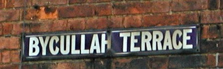
The section of Hatfield Road between Arthur Road and Woodstock Road South.

In passing, the Marshalswick connection is Jersey Farm, for Dr Corner moved his farm from a part of Enfield Chaseside close to the Northern Hospital because the Piccadilly Line extension was being built nearby.  More of that on another occasion.  

Enfield Chase and its early settlements, some of which still feature within the modern London
Borough.  
COURTESY THE ENFIELD SOCIETY


The outer terminus of the Liverpool Street to Enfield Town station which helped to promote
early residential commuting development in the nearby Bycullah estate.


There has been a long-standing bus connection between St Albans and Enfield.  Route 313 bus
waiting at St Peter's Street.

We will focus on the Fleetville connection which is close by on Chaseside, west of the historic town of Enfield.  The Chase itself was an ancient open and wooded space across the boundaries of Hertfordshire and Middlesex.  As London expanded and the communities of Southbury, Edmonton and Enfield itself, grew larger, the part of the Chase close to the Town (Enfield Town) attracted the first railway route (of three), so an estate close to the station and close to the western boundary of the existing urban area was sold for residential development; mainly large detached villas and equally spacious semi-detached homes, of which the key road was named Bycullah Road.  Today the majority of the addresses have been replaced by blocks of flats and modern town terraces.

Bycullah House and its extensive grounds in the early 19th century before the City commuting
 estate across nearby Chaseside.
COURTESY NATIONAL LIBRARY OF SCOTLAND

Before the early 19th century development there was already one sizeable estate property immediately north of the station, separated only by Windmill Road.  It was named Bycullah House.  The estate land probably amounted to several acres having been purchased by a retired officer of the British Indian Army, Col R D Riddell.  At present I am limited to evidence from published maps which show a large house, a number of separate buildings, lawns, formal gardens and smallholdings.  A private drive (later extended into the current road called Bycullah Road) connecting with Windmill Hill.  Bycullah House, and therefore the later Bycullah Road was named by Col Riddell from his association with the district of the same name in Bombay (now Mumbai).

Portion of late 19th century Bycullah estate to the west of Bycullah House from which the
estate and its connecting road took its name.
COURTESY NATIONAL LIBRARY OF SCOTLAND

After Col Riddell's occupancy of the House, and its subsequent owners, the Bucullah residential estate grew beside it.  Within around 70 years a writer and printer with some experience and investment moved into Bycullah House.  His printing business was adjacent to Fleet Street, easily accessible from the Town station.  His name was Thomas E Smith, who had opened Smith's Printing Works at Fleetville in 1897.

The connection with Fleetville begins here with Thomas E Smith both owner of Bycullah House
and Smith's Printing Works, the beginning of Fleetville, then outside of the city boundary.


He had naming rights over the nearby roads, including the section of the Hatfield road adjacent to the works, which he called Bycullah Terrace.

Mr Smith died in 1904 and Bycullah House passed on and remained occupied until the Second World War, surviving as a building, but minus much of the remaining surrounding grounds, until the 1960s.  However, we can show that a residential road in Enfield and a very short length of Hatfield Road, Fleeetville remains as a link to Thomas E Smith and a Colonel of the British Army in India.

Bycullah House has now been replaced by infill housing.  Bycullah Road is at the bottom of
this aerial view.  Halfway is a new access drive to the modern houses, which was the original
access via a private driveway and Windmill Hill.


Friday, 19 January 2024

Tollgate

 In the UK there are  approximately 112 roads with the name Tollgate* in them, for all suffixes (lane, way, street, road corner, and so on); in addition there are a modest 15 roads with the word Tollhouse in them.

The first of several Tollgate Road street plates after leaving High Street, Colney Heath.

The answer to the question why such a route contains Tollhouse or Tollgate must be straightforward enough: during the period of around two centuries up to c1880s (although some closed earlier) in which  turnpike roads existed it is surely a section of road approaching a toll gate and/or toll house which will have been given – verbally at least – that most obvious of names.

In much the same way as so many roads in the vicinity of railways are labelled Station Road or Bridge Street.

The side road gate and house (no longer extant) near Hatfield Road in Colney Heath Lane. Named
Hut Wood Toll.  Painted by John Westall.

Through our east end of St Albans passes a section of the Reading & Hatfield Turnpike. Today the route is Hatfield Road and St Albans Road East, and if you peruse the website www.stalbansowneastend.org.uk you will discover a whole topic about the R&H, including its side roads which branch from the turnpike and where toll houses and gates lay in wait for those paying a charge.

But there is a road with the label Tollgate Road just east of Colney Heath village, although there appears to be no recorded Turnpike Trust to control this length of road.  Tollgate Road begins at the roundabout at the south-east end of High Street, Colney Heath.  It retains this name until becoming Dixons Hill Road shortly before reaching and bridging the A1(M), a modern road, although in former times the target would undoubtedly have been the Great North Road which is now labelled A1000. 

High Street view south-east to the start of Tollgate Road.


On the north side of the road was a separate farm known as Little Tollgate Farm, the main farm
on the south side.  Both are now Tollgate Farm.


After the road changes its name to Dixons Hill Road in the vicinity of today's A1(M) it passes
through Welham Green.


Evidence from various maps shows various short sections have been remodelled to enable the road to join the A1(M) and then aim for the A1000 near Welham Green Station where this road is still formally named Great North Road.  This section of the Great North road was controlled by the Galley Corner to Lemsford Turnpike Trust (Galley Corner can be found near Enfield).

The road crosses over the railway and reaches today's A1000, Great North Road, which was
controlled by the Galley Corner & Lemsford Turnpike Trust.

So we know of two turnpikes, the Reading & Hatfield, and the Galley Corner & Lemsford, between which appears to be a roughly west-east road by the names of Colney Heath Lane, High Street, Tollgate Road and Dixons Hill Road (formerly just Dixons Hill).  The give-away name is, of course, Tollgate Road.  Further emphasis is placed on the name as it passes Tollgate Farm, and formerly Little Tollgate Farm on the opposite site of the road. And that's not all; an area of nearby woodland has been called Tollgate Wood.

The vehicle is turning into the entrance of (Little) Tollgate Farm, as shown in an earlier photo.
Take note of the green bank beside the road and in front of the car.  The constriction would have embanked or possibly fenced to enclose half of the present road's width.
We will observe it on both of the maps below.

At this point we should refer to a detailed spreadsheet listing all known tollhouses, whether extant or lost, in Hertfordshire**. Number 34 on the list names the gate "North Minns" [sic] but describes the location of the gatehouse as "Tollgate Farm, Colney Heath, Roestock."  Further location detail describes "Tollgate Road, from Mimms Hall, north of North Mimms Park."  Rather disappointingly, the spreadsheet informs us that, as with the majority of gate houses in the list it is "lost", in other words, it no longer exists  and had not done so at the time of the 1890  OS 6 inch map.  Visual inspection of the 6 inch and 25 inch map of 1897 confirms this.

Although there were occasional buildings along Tollgate Road at this time, none was labelled Toll House and none existed on the boundary of the road as would be expected if the intention was to restrict road width and stop traffic to collect tolls. 

There is one more alleged fact about Tollgate Road.  While the majority of turnpikes were organised by Trust – the clues are in their names – an unknown number were privately owned, and the toll road where this house presumably stood was allegedly a private company. So the same amount of data does not survive in the public record.  It is not possible to prove that its private status is the reason for such lack of information; nor is it possible to prove how long in distance the private road was.  It is likely the majority of vehicles using it were making passage between the turnpikes at the Hatfield Road and the North Road.  A toll house midway would have seemed a likely option.

Until now we have one tantalising clue about an apparently privately owned turnpike (or toll) road, but insufficient to be specific about exactly where, nor its specific purpose.

Section of OS six-inch map surveyed c1879.  The Y shape road layout.  Bullens Green is at the top
with Tollgate Road to Colney Heath to the north-west corner and towards Great North Road
southwards.  At the centre of the Y is a curved line on the right of the road which 
represented a bank constricting the road width.  
Beside the curved line are the lettersTP (Toll Point)

COURTESY NATIONAL LIBRARY OF SCOTLAND


The larger scale survey of 1896 shows a more accurate boundary of the obstruction and
a mark indicating it is nevertheless part of the road.
COURTESY NATIONAL LIBRARY OF SCOTLAND

Or are we just not searching well enough?  Searching an earlier OS six inch map does finally reveal where it was; the standard abbreviation for a toll house and/or tollgate is TP, (toll point). It doesn't exactly show a rectangular formation to represent a permanent building, but it does mark a narrowing of the road on the east side – and it is located right outside the entrance of Tollgate Farm itself.  Cross checking with the OS 25-inch map for as late as 1897 the same curved line on the road surface is in the same location, although the abbreviation TP is no longer marked.  The curved line drawn on the roadway would have represented a bank of grassed covered soil or some other obstacle to constrict vehicles to to use a deliberately narrowed part of the road for the benefit of the toll collector.

It is therefore very likely that the private owner of the toll road was also the owner of the farm.  We now have a good deal more knowledge than when I was passing the street plate in the car and asking myself that initial question!


* www.findmystreet.co.uk

** www.turnpikes.org.uk

Saturday, 6 January 2024

XL-ALL Seeds

 Get ready for our first sleuthing project of the year.  If you are a long-standing reader of the SAOEE website the letters XL-ALL may resonate with you, especially if you occasionally spin through the Questions and Questions Answered pages.

A Ryder mature company catalogue by 1930.


Since the turn of the twentieth century Samuel Ryder's company, Ryder's Seeds, had been operating successfully in the city and was a nationally known brand.  Not only did it feature a very wide range of seeds, but the company operated a mail order facility on a fast turn-round, and boasted packets from one old penny – "penny packets" as they were known.  And if there is a profitable and highly successful trader there will always be a copy-cat business person attempting to deceive purchasers into falsely believing they will be buying the genuine product.

By 1907 such a copy-cat firm was advertising seeds: "the most remarkable business enterprise of modern times.  The seeds are sold at the uniform price of 1d [one old penny] per packet."  The advert tells us that "St Albans is known the world over as the distributing centre for these seeds."  But this advertising blurb did not refer to Ryder's Seeds. This was a firm from Leytonstone, not St Albans.  Nevertheless it allegedly brought its operation here, although we should be mindful  it could just have been a registered address.  Its brand name was XL-ALL, giving the address of Hatfield Road.

When customers contacted the company they were sent catalogues which were, in part, copied versions of Ryder's Seed Catalogue.  Of course we cannot say whether or not XL-ALL actually had seeds to sell; possibly they received the orders, kept the remittances but omitted to forward the seeds.  But even if customers did receive seeds from their orders they certainly were not Ryder's seeds.

We do know that Ryder's took the upstart to court and a restraint of trade order placed on XL-ALL.

All that remains is to discover which property in Hatfield Road was in the hands of XL-ALL for this short period of time.  That is where the matter has rested for the past ten years – until last week at the end of December 2023.

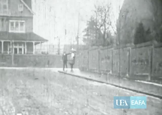
I had spent an afternoon searching new and interesting movie film titles which had links to St Albans and which were lodged with the East Anglian Film Archive, storing stock from Bedfordshire, Hertfordshire, Cambridgeshire, Essex, Norfolk and Suffolk.  Among the titles I viewed was a short three-shot silent from 1907 – note that year, which was mentioned above.  The film's title was The Animated Pillar Box made by Arthur Melbourne Cooper of St Albans.

The Animated Pillar Box, shot 1
COURTESY EAST ANGLIAN FILM ARCHIVE


On this post are three key stills from the film, one of which provided a connection with the Ryder- XL-ALL story above.  Cooper just happened to include details of a company painted on a wooden gate. Today we might call it product placement, but in 1907 the details  probably just happened to be where Cooper was filming. Coincidental.

The link is:

https://eafa.org.uk/search/?q=&titleDateFrom=1890-01-01&titleDateTo=2024-12-31&perorg=&agentActivity=&locations%5B0%5D=Hertfordshire&featured=&workType=&descriptionType=&sound=&colourType=&searchSort=relevance_desc&pagination=5

The sixth title in the page list.

Why not freeze the film after the first very long shot and take in the white hand-painted sign announcing the location of XL-ALL's warehouse, apparently behind the gate.


The Animated Pillar Box, shot 2. Was this the opposite side of the road shown in shot 1?
COURTESY EAST ANGLIAN FILM ARCHIVE


The Animated Pillar Box, shot 3
COURTESY EAST ANGLIAN FILM ARCHIVE


The long first shot give us plenty of time for take in the house in the background, the T junction foregrounding downhill, with a footpath and fence behind.  The roadway appears to be rather longer than is first seen in shot one, the lower section only seen in the third and final shot.  The painted fence sign may have been nearby.

Remember, the 1907 advertisement stated the firm was in Hatfield Road, but that is a very long road, extending from St Peter's Street to Popefield at Smallford.  Perhaps it was the nearest developed location to Hatfield Road.  Or the house, of course, may have been demolished at any time since 1907.

So the question is, do you know where the house and its junction is, or was?  Any ideas anyone?


Monday, 1 January 2024

Remembering 1923

 Time to look back even further than last year as it is now we are at least one day into the new year.  As I have blogged previously I'm jumping back before our memories; back to 1923.  Why not indeed?  So here are a few events which St Albans people found to be recent by the end of 1923.


Walking out of the front door of the King Harry PH and into a quiet open space.  Such was the
1920s and earlier.  This view from Watling Street is deceptively quiet for even then this was considered a dangerous junction with poor sightline.
COURTESY HERTS ADVERTISER


King Harry corner: a long time before traffic lights appeared, the junction had long been realised as dangerous, but it would be much improved if various outhouses of the public house were removed.  Clearly any improvements didn't arrive early enough as the field (now St Stephen's estate) had already been purchased for housing and therefore constrained widening and visibility.

Cock Lane: the top of Hatfield Road between St Peter's Street and Marlborough Road is about to be widened.  So, with the benefit of hindsight we can conclude the road does not seem very wide today!  It also helps us to date the Blacksmith's Arms PH which was rebuilt further back from its original footprint.

Swimming certificates: for those of us who remember working hard for these little sheets of thin card, certificates for 25, 100 and 440 yards were awarded for the first time to children attending the city's elementary schools.

It was proposed that the market stalls should be lit by electricity; but these matters take much time to resolve and I recall it being the early 1950s before stalls not in The Square were converted from hissing hurricane lamps

In 1923 the Market Square became a car park on most days of the week (see item further down).
It is difficult to see Waddington Yard (now Waddington Road) in this photo.  In the left
background there is a narrow gap between the buildings, which opened out a little behind into
a yard, hence its former name.  The pub on the frontage was demolished to provide car
access and it became Waddington Road.
COURTESY ANDY LAWRENCE

In 1923, and a good time after the access to Spencer estate and Worley Road from St Peter's Street was still called Waddington Yard.  There was a public house on the corner called the Rising Sun.  This would be pulled down to widen the access.  This happened – eventually – and the name changed to Waddington Road.  But it all started in 1923!

A small parish school along Watford Road, St Stephens, was proposed for closure, with just 33 pupils left, although there had previously been over 60.  Interesting move as the field across the road was about to become St Stephen's estate, and a field on the other side of Chalk Hill (now cross by the A414 was M10) had just been sold for development. Fortunately, the closure was temporary.

The sale of Marlborough House in 1923 prompted a swift change in the Victoria Street 
streetscape.  The line of trees on the right are between Trinity Church and Lattimore
Road, but within a very short time they would be gone with the development of
Victoria Street and Marlborough Gate behind.

Marlborough House, off Lattimore Road, and formerly owned by Samuel Ryder, changed hands in favour of the newly arrived Loreto College. This also marked a huge change in the Victoria Street streetscape, which many residents subsequently recalled as a landmark year.

Oster Hills: this substantial private house was sold and became part of the St Albans hospital estate, initially for the accommodation for nurses; the name Oster Hills quickly became more widely known by St Albans folk.

The Poly: the end came for this much converted and altered cinema in London Road. It succumbed to fire originating from the projection room – in those days of highly flammable film.  The cinema was fully enlarged and rebuilt in 1928, and is still popular one hundred years later as the Odyssey.

Public toilets: in 1923 they were beside The Boot PH in Market Place and not well-favoured.  New toilets were to be built attached to the Clock Tower, but of course, these never materialised. Try the Town Hall or George Street!

You may have forgotten, or never knew, but 1923 was the year when The (Market) Square became a parking plot for cars; except for Wednesday and Saturdays of course.  

Not St Albans, but near enough, in the very early days of Welwyn Garden City – how excited St Albans people were to learn that news and its founder Ebenezer Howard. The Canadian-owned Shredded Wheat Company has decided to build its factory in the garden city.  Its arrival gave the new railway station its informal sobriquet: "a return to Shredded Wheat please!"

Though detailed reasons were not given it was announced that unemployment figures for the last year had fallen from 636 to 363. Which must have given many unemployed or lightly employed residents some hope in a dark world.

By the end of 2024 we'll discover what became the events of the year in 1924, but you won't need reminding of the events of the year on which we are about to embark; they will still be fresh in our minds.

Have a fruitful, enjoyable and successful year; we hope there is much for us all to look forward to.


Thursday, 28 December 2023

Remembering This Year

 The first blog of 2023 looked back, not to 2022, but a full one hundred years to 1922.  That was a fascinating year that was.  I'll jump back to 1923 next time, but for now I will modestly roll back to the beginning of this year and will probably grasp how swiftly the months of this year have flown by – so quickly sometimes I have managed to record just two posts in an entire month, reaching the usual average of 36 this year.  But there has been an increase in series posts, so I will begin with these.

One of five titles in the series of little books about St Albans, and presented as a sequence of photographs, mainly taken between c1880 and the Second World War.

In the summer I felt it desirable to alert readers to a number of books about St Albans which are often neglected – I've called them The Little Books – slim volumes, small page sizes, a minimum of text, but the main feature is their prominence of photographs.  We are allowed the pleasure of focusing on one page at a time.  I covered five such books and assessed what proportion of the images shown were photographed in our east end.

With the publication of the city's Green District Plan there followed a short series of posts about some of the East End's green open spaces, including pocket spaces and forgotten places which, nevertheless, can inspire us or help us to collect our thoughts.

Opportunities to relax in the district's open spaces were explored after the publication of the District's Green District Plan.

A more recent series which I'll return to occasionally, are visits to individual roads or lanes; how and why they first appeared and what might have made them special.  This series began with Shirley road where, it appears, few of us have heard of.  And this road came about in the series because I wanted to highlight an unusual building along Shirley Road whose main function few had seen, and now it is too late.  It was the local equivalent of a British Restaurant which we. in St Albans, knew as a Civic Restaurant.  The restaurant building was finally removed from the scene c1975. So far you can read about the roads of the Breakspear estate, Coach Mews, Sutton Road, Royal Road and Princes Road; others will appear during the course of 2024.

Another short series reminded us of the old names by which fields were once known, and had been remembered for possibly hundreds of years.  One collection of fields was, and is still remembered as, The Nine Fields, between Brampton Road and Sandpit Lane.  And nine appears in the names of other east end fields too.

SAOEE Blog has not been without controversy in its reporting this year.  St Albans City Football Club had applied for an entertainment and music license – or rather a substantial extension to the existing control.  Which, naturally, drew the attention of the Clarence Park Residents' Association and Protect Clarence Park Campaign Group. 

The Blog also helped to celebrate the centenary of the appearance, on maps and signs, of the road classification system which help us to navigate ourselves around the road network, by letter, number and of course by colour.

Among the thousands of children who were evacuated to the city between 1939 and 1945
was a contingent from Ore School, Hastings, whose host school was the now-closed
Priory Park School.

Two contrasting blogs, both published in the summer and both engaged the attentions of the majority of the population in their times. The first in this year of 2023 when the Coronation of Charles III was celebrated, with its street parties, decorations and other special events. When we might have been tugged down with more difficult daily circumstances the Coronation was a short relief of positive buoyancy to bring a few days of light relief.  Contrast that with almost exactly eighty years earlier when it seemed like half of the nation's population appeared to have been on the move, or in some theatre of war.  And a part of this was the movement of children from the large cities to places of comparative safety in the towns and villages of "reception areas".  They faced new temporary lives without their parents; and the millions of adult hosts who accepted them into their homes faced new responsibilities and pressures in looking after their child and/or adult guests.

What a year!

To all my readers of the SAOEE Blog I wish you a very Happy New Year.


Tuesday, 12 December 2023

Princes Road

 The naming of roads is often intriguing; last week, for instance I explored Royal Road, which probably would have received a rather different name, connected with Fleet Ville's new housing  development, part of the Fleet Printing Works.  Except, that is, Queen Victoria's jubilee was soon followed by her death, and all sorts of royal-related features sprouted around the town.  

The original c1900 development plan from Messrs Hassell and Tomlinson.  The two
coloured blocks show the higher value dwellings to be built (light mauve on the right;
the larger pink block were for lower values. Note, the partnership also built the first
pair of houses in Brampton Road south.  However, the map completely
ignores the presence of Burnham Road being built by rival developer, Mr Horace
Slade.


Princes Road and connections.
COURTESY, OPEN STREET MAP CONTRIBUTORS

So, in addition to Royal Road, Princes Road was added to the street scene.  So, to set the context, George V succeeded Victoria and thus launched the House of Windsor.  George and Mary had four sons, as well as a daughter (Mary, named after her mother). Regrettably daughters were not recognised with the same importance. The princes were Edward, Albert, Henry George, and later came John.  So our Princes Road references four – or if you include latecomer John, five royal princes.

If you were going to announce where this new road came to be located  in the Fleet Ville landscape, it may appear as a minor disappointment to say it filled in a gap!  But that is what happened. A long straight roadway split into two, the first was a trackway beginning at the Marshalls Wick House Drive (now Marshals Drive), would in future become Homewood Road.  An equally straight roadway then continued parallel to the east boundary of the Spencer estate, which was initially called Woodside Road, reaching the top of a steep slope before petering out.

Taken c1914 Princes Road crosses ahead from left to right.  Eaton Road is complete and the
slopes beyond will later become Salisbury Avenue.  Sheppard's bakers are already established
in the district.
COURTESY HALS

From Hatfield Road one of the three Fleet Ville roads was laid for a couple of hundred yards until it reached the footpath between Hatfield Road, Beaumont and St Peter's Church across the fields.  Tess Road stopped at the footpath because that was the boundary of the field printing works owner Thomas Smith had purchased.  

So between Woodside Road (from 1906 renamed Woodstock Road and from 1948 Woodstock Road North) and Tess Road was a road of nothing!  Tantalisingly, other roads were also in build; Brampton Road, and roughly in the middle of the gap to the west was Burnham Road, both being Mr Horace Slade's building estate and both stopping well short of the gap.  Then there was, to the east, the distant line of Beaumont Avenue and a prepared new road called Salisbury Avenue.

 A building partnership of Edward Hansell and Thomas Tomlinson eyed this irregular potential building site with its multiple connections to other roads, acquired it and started construction.  Instead of retaining the names Tess or Woodside, and because a royal opportunity was too good to miss in 1900, the partnership went for Princes Road.  Nearly half a century later these were the homes which would have to be renumbered as Princes gave way to Woodstock South.

Tomlinson and Hassell were only successful in their bid to build houses because St Albans Corporation had considered purchasing the same field a full two decades earlier to use as a cemetery, but decided it would be too small and too far away from St Albans, settling on the present cemetery location instead.

View southwards from the hop of the hill at Woodstock Road north.


Princes Road west with the Brampton Road junction to the right.

The street plate shows the demarcation between Woodstock Road North on the left,
and the northern-most homes of former Princes Road (now Woodstock Road South)
on the right.

View from the houses north of Burnham Road towards Brampton Road (see the second view in
this series.

Finally, the homes between Burnham Road right) and the tree-lined playground of
Fleetville Infant and Nursery School.
SERIES COURTESY GOOGLE STREET VIEW

The estate may have been small in size, but it welcomed residents and passers through from many directions.  In the post WW2 era Princes Road also brought buses (354 Fleetville Circular) from Woodstock Road North to Hatfield Road, and from Brampton Road to Woodstock Road North.  And you could not have been much closer to a local school.

In case you might have thought so compact a development could have been completed quickly, the first two pairs of homes, opposite each other, were completed c1902, but four homes adjacent to Brampton Road and four homes adjacent to Eaton Road remained unbuilt land until after 1910.

At least Princes Road remained remarkably free of flooding, a regular feature of the Eaton Road arm of the estate, but the road's even numbered houses were probably beset by some soggy rear gardens as a result of the proximity of same stream which crossed Eaton Road.


Saturday, 2 December 2023

Royal Road


Fleetville Schools (now Fleetville Infants & Nursery) and four of the semi-detached homes
on the east site of Royal Road.
COURTESY GOOGLE STREET VIEW

 When we refer to Fleetville these days we keep in our mind a much wider area than was originally planned, a tightly packed community of three roads on the north side of Hatfield Road and an associated printing works (now redeveloped as Morrison's on the south side).  For a few short years there remained fields on all sides.  And the name Fleet Ville took its name from the the T E Smith printing company's London headquarters just off Fleet Street – the name of the printing factory locally being named Fleet Works.

Fleet House, now flatted.  The original front porch and door observed by the central
cleaner brickwork. The original gateway was to the right of the parking sign.

As with many speculative developments Fleet Ville was not completed.  Arthur Road was finished, and Tess Road (now Woodstock Road South) was partly complete, although most of its west side was purchased for use as a school and a police station.  Royal Road was barely begun.  We will recognise the three semi-detached pairs of cottages built in the early 1900s, and the Fleetville Schools building whose plot spread Royal Road and Tess Road. A detached property, Fleet House, had nothing to do with the  Printing Works and was not added to the corner plot until the 1930s, becoming the home and practice of Dr F Smyth who had previously occupied an apartment at Bycullah Terrace. Currently the building is in the middle of yet another transformation into flats.

The west side of Royal Road remained unbuilt and passed to Mr T E Smith's son after his death in 1904.  The imperative to complete the housing plan begun by his father, Mr Smith jnr recognised there was no real need to complete the company housing accommodation given the fast-growing building estates between Royal Road and The Crown.

We will never know how Mr Smith's estate would have been laid out as no plans have made it into the public domain.  We assume the west side of the road would have been completed, with a cul-de-sac parallel to Hatfield Road to abutt the boundary of the Slade estate at the eastern end of the Harlesden Road rear gardens.  

The north end of the road with a newly built house at the end of a Burnham Road plot.
The original intention was to keep the roadway open into Burnham Road.
COURTESY GOOGLE STREET VIEW


Later homes built across the intended road junction.
COURTESY GOOGLE EARTH

The northern end of Royal Road was left open, as were the plots intended for Burnham Road behind.  Connecting agreements were not made and after 1910 three additional houses were constructed to the Burnham Road frontage.  Royal Road therefore became a permanent "dead end" and access to Burnham Road was limited to its two end points, Harlesden Road and Princes Road (Woodstock Road South)*

A pre-WW2 photo taken from where the present community centre is now located, and
showing the original railings along the Royal Road frontage.
COURTESY FLEETVILLE INFANTS SCHOOL & NURSERY ARCHIVE

Charles Woollam, a generous benefactor to the city's communities, acquired the remainder of the Smith land and, in 1913, gifted it to the city for the free use of the people of Fleetville as a "pleasure ground"; generations of Fleetville people have identified it as Fleetville Recreation Ground (the rec.) and today many of us know it as Fleetville Park.  That year the city council came close to using the ground for emergency allotments, but instead seeded the soil, gifted us with a set of swings, and installed metal railings on all four sides with gates to Hatfield Road, where Beech Tree Cafe is, and opposite the boundary between the school and house number 12.  Interestingly, gates were installed at the end of the rear gardens of the Burnham Road houses, giving direct access to the Pleasure Ground.

The WW2 underground shelters, still entombed on the recreation ground.  The 
emergency exits are still visible and quite clear in hot dry summers

In 1938 open zig-zag trenches were dug close to the rear of the Burnham Road gardens (perhaps that was when their gates were installed?) and close to the Royal Road gate.  By the war outbreak these trenches were deepened, widened, interconnected, capped and with emergency exits installed – the latter still identifiable in hot dry summers.  An emergency water tank was constructed close to where the zip wire is today.

The temporary nursery brought to the recreation ground in 1942, and still in use as 
Fleetville Community Centre.  A replacement building is planned – finally!

In 1942 a temporary concrete and block building, pre-formed in Hoddesdon, was brought to this site to serve as a nursery for the mothers working at the munitions factory (site redeveloped as Morrison's).  Temporary it might have been, but the same building is still in daily use as Fleetville's Community Centre.

In the early 1950s part of the west side of Royal Road was marked out and signposted as the district's first street parking zone.  Today, it is all but impossible to find a spare parking spot anywhere in the road!

Finally we return to the name by which the road is named.  The plans were being prepared in the period up to 1900; Queen Victoria had celebrated her jubilee, the royal accession and the royal princes topped newspaper stories.  So it was not a surprise for this little cul-de-sac to be awarded a royal association.

* It should be clarified that Tess Road only extended to the entrance of the public footpath, known locally as The Alley.  Between this point and the mouth of Brampton Road was separately developed as a road named Princes Road.  These two roads retained their separate names until 1948 when they were renumbered and given a common name: Woodstock Road South.