Friday, 24 July 2020

Between bakery and dairy

In the previous post we met builder Herbert Skelton, who was also a developer.  He purchased the rights to build the four shops to the east of Blandford Road, with Jacob Reynolds' Blandford Road lying behind.  This was in 1912, over a decade since the first attempts to develop Hatfield Road as a residential street, only to discover that they were commercially better as shops.  Mr Skelton had built a portfolio of homes further east: two terraces which lay between the former J B Rollings house and his wholesale warehouse, and Glenferrie Road.  He got started on these much earlier, 1902, and managed to retain most of them as cottage homes for almost ten years.

The shops – and two homes between Clifton House (see previous post) and Glenferrie Road.

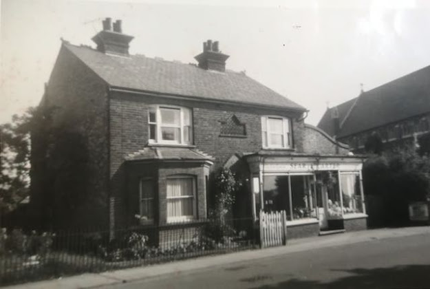
These are two almost identical terraces, with attractive boarded gable ends.  Their current condition reflects the difficulty of carrying out maintenance on this part of a building  The first terrace of four, 119 to 125, consisted of houses.  Indeed, two of them are still private residences, each with their narrow front walled gardens.  When first built all of the properties were homes with porched doorways and ground and first floor bay windows.  That would have been an impressive lineup for the first few years.  The photo below marks the major change in use.  

This image was created in 1911 from outside Clifton Road looking eastwards to Glenferrie
Road, along a still-narrow road.  Here is the bakery in the only year it was managed by William
Davies, followed by the two houses.  Shop blinds reveal the presence of newly-converted
shops.  No parking problems – bliss!
COURTESY HALS, FORMERLY ST ALBANS LIBRARIES

1911 is the first year in which most of the homes became shops, with the removal of the ground floor bays and installation of shop display windows and a door giving entrance to the shop and the existing front door retracted to become an internal access to the first floor from the shop.  They were narrow properties.  We know the photo was taken in 1911 because number 119 became a bakery, losing its little garden in the process, and it was run by Walter Davies.  He only remained for one year, the census year of 1911, and by the following year Mr Freeman Cornwell had taken over.  119 has always been a bakery; even in modern times when it became a pizza specialist.  The carriage house, an earlier form of garage, cart house or workshop lay along along the side entrance and was used for flour storage, although not for the first few year as Mr Skelton and his family were living there.  The workshop is still there at the far end of the sideway. Some present residents of the district will recall a fire at the shop which effectively put the bakery out of business for some time.  During the 1950s the author was fortunate in having the owner's elder son as a friend, and it was to the shop, his home, we gravitated to after school to mop up any stale buns Mr Schnabel was unlikely to sell before closing time.

The bakery shortly after the fire.

In the first terrace, number 125 at the other end, was another shop recalled by the author.  Although in its first few years it was John Schaper's hairdresser, the majority of its life was spent as a confectionery, managed by Mr O'Dietschi and then by Mrs Fowler.  Ice cream and pop were the young customer's regular requirement!  From the 1970s it became a charity shop and is now a small art gallery exhibiting on behalf of a small number of today's artists.

A traditional view of a confectioner's shop.  How could a child avoid
making regular visits to Fowler's!
COURTESY FLEETVILLE DIARIES

It is lovely to note the two intervening terrace homes between the two shops described above.


The first two shops in the second terrace, 127 and 129, also small homes to begin with, served Fleetville residents with a wider range of products: bookmaker, a bazaar, milliner, government surplus supplies and hobby stores – most of these are variations on a theme! Today it is a nail bar.  Next door today's popular Fleetville Kitchen cafe was preceded by cooked meats and carpets (but not at the same time!)

The final three shops:  Santino's which is now Fleetville Larder; an insurance business which is
now a firm of solicitors; and Cleveland Glass, which now seems to have moved online.

A shop trader well known in these parts between the 1950s and the early 70s was racing cyclist Stan Miles.  He took over from a children's outfitter, and his shop, clearly a converted living room with its fireplace still in position, attracted a large number of teenagers who aspired to own a new cycle they could hardly afford.  Above the fireplace hung the "cycle of the week" which was beyond our reach in more than one way. He later moved his trade to the south side of Victoria Street.

Glenferrie Stores managed by William Lupton between shortly before
WW1.  Could the bikes be fore the delivery boys?  Typically, two shop
windows crammed with inviting products to purchase.
COURTESY IAN TONKIN

We have now reached the next corner, the one with Glenferrie Road. This is where the two terraces differ.  At the right end of the second terrace, this was always going to be a better commercial location for a corner shop, and number 133 never was a house, opening as a grocer in 1903, and among its early tenants was William Lupton, grocer.  He began here in 1906, before moving to number 63 on the corer of Laurel Road until 1914 and closing in Fleetville permanently in 1916,  For much of its life it became Brown's Hedges Farm Dairy and Express Dairies.  Until recently it was also Cleveland Glass.

This is a good opportunity to mention that the property numbers are those in use today.  Until 1932 the numbering was mere guesswork as so many plots had not been developed.  Many of the early buildings erected as homes can still be found in the street directories with their house names.


Wednesday, 15 July 2020

The Skelton investment

In our exploration of the properties lining Hatfield Road eastwards from The Crown, Rumballs land agents had enabled Horace Slade to acquire Great Long Field (or Long Field East as it was also known).  The hedge separating Long Field from Long Field east met Hatfield Road just before the line of Blandford Road, so when Frank Sear first purchased the land for his nursery and its shop and house it was on the east side of the hedge and in Long Field East.  But Jacob Reynolds of Heath Farm expressed an interest in part of St Peter's Farm and purchased a strip of land on each side of Blandford Road.  He was clearly only interested in residential development,  not main road development.  His purchase had not included Sear's future Ninefields Nursery, nor had it approached the main road on the east side of Blandford Road.

An early plan of the land purchased by Joshua Reynolds.  The road names
have not yet been agreed, but the land is on either side of Blandford Road.


In stepped Mr H Skelton, a builder from Luton who purchased an interest facing Hatfield Road when development first began in 1899.  On this land he straightaway built two terraces of four houses each.  There will be a closer look at these in the next post.  For now, that land accounted for only half of the Hatfield Road frontage in his ownership.  From Blandford Road he was content to leave a sizeable plot vacant for a full ten years.  As for living close to the job, he, his wife, son and daughter, occupied four different properties, at least two of them – and maybe all of them – he had been responsible for building.

Mr Skelton's purchased land east of Blandford Road.  The first building, consisting of four purpose- built shops was not developed until c1910.  On the far right, the building beyond Asker's awning is where J B Rollings ran his wholesale confectioner's business.  The rectangular clock is fixed
to the first floor front elevation.
COURTESY ST ALBANS MUSEUMS

The ornate balustrading hides the view from the street of the second-floor windows, which are
nevertheless visible from the more distant view shown in the top picture of this pair.

In 1910 the design for a terrace of four at the plot-in-waiting at the Blandford Road end was agreed and proceeded with, and would certainly have made a greater impression than his earlier gable ends further along the road.  Those who only look down or ahead when walking along the road may not have noticed.  Neither is it obvious to many of us that this terrace is triple floored.  Above the ground floor, which was intended to open straight onto the pavement rather than via a slim six foot garden space, the first floor has residential squared profile bay windows and adjacent ancillary rooms with a flat window.  Except the corner property, which only has a longer bay window, which is angled; no flat window for another room.  The reason for this becomes clear when we look around the corner.  These appear to be more than tiny flats and all four extend some distance to the rear.  Number 109 has two windows overlooking Blandford Road, a benefit not available to the other three properties; it is therefore probable that the internal layout is different.

The third level attic room windows are mainly hidden behind an ornate stone balustrade with the roof drainage fed downwards from pipework below balustrade level.

Since 1922 number 109 has been a home of St Albans Co-operative Society grocery department.  The author only remembers it from the 1950s, when it was already self-service, except for the delicatessen counter. Home delivery, so popular once more, was also a feature back then; the customer handing in a notebook, with requirements ticked if supplied, and the assistant calculating the cost.  Even "subs" were taken into account if the exact product wasn't in stock.  Today it is still part of the Co-op as Funeral Care.

Next door at number 111 it took until 1938 for the Co-op to open its butchery, which previously had been an independent shoe shop and a gents outfitter.  The shop front was fairly impressive, with the lower facing panels having a black stone grained finish, and heavy glazed doors with shiny metal edgings.  When the Co-op opened its supermarket its little local shops closed.

The third Co-op shop in the row, number 113, was its greengrocery and then Society Dry Cleaners, but only from the early 1950s. Before then the sign above the door welcomed young people to the Carlton Club, while the fascia stated Bishop's Stores.  The shop attracted a number of young people and one of the activities which came out of these comings and goings was a very successful football club.  To this day, a detail page on the St Albans City Football Club's website carries photos of the teams of young people from the immediate post-war period.

A 1945 Carlton team pictured at Clarence Park
COURTESY THE GORDON JAMES COLLECTION

Number 115's first occupant was a trader which later became well known for its delicatessen shops in Victoria Street and Chequer Street, Saxby Bros, but by 1930 A Asker had taken over what had previously been a watchmaker's and then become Fleetville's pawnbroker's shop.  Today it is a cafe.

Mr Skelton's purchased land facing Hatfield Road between Blandford and Glenferrie roads is
boxed in orange. The properties in this post are numbers 109 to 115, and number 117.
MAP COURTESY NATIONAL LIBRARY OF SCOTLAND


And finally, in this post ...

Mr Skelton had a plot of land left between the 1910 development we have explored today and the two terraces of houses to the east and which we will find out more next time.  Around 1920, and because of the small amount of extra width he allowed a shop for Mr John  Blackmore to run a drapery business, with residential accommodation to the side rather than above or behind.  However, for whatever reason Mr Blackmore sold up within a couple of years in favour of a man well-known in Fleetville, Mr John Bradbury Rollings.  He was living in a small house in Brampton Road and in charge of a small wholesale business.  The urgent need to expand brought him to buy number 117, which he named Clifton House after the house he had previously owned in Finsbury.  As he did not need the attached house for residential purposes, this, along with the shop, became the new warehouse.  The top photo, taken in 1964, shows the property – it is the one with the rectangular clock attached to the frontage.  Compare it with the picture taken in 2012.  The right side which was the original shop received a significant change, both to the frontage and to the roofline.  In the 1960s, further expansion forced the company to move into a warehouse at the top of Camp Hill, number 117 eventually being the home of a popular computer accessories retailer called Beebug.

Add caption


We have seen a considerable range of traders moving into this growing party of the city, and either staying because they were successful, or moving on after a while to try their luck elsewhere or in the search for larger premises or more popular locations.  This week Saxby's, Rollings and the Co-op did just that.  Next time we'll see how Mr Skelton's terraces of homes fared.


Monday, 6 July 2020

Ninefields Nursery

We have nearly completed our exploration of Hatfield Road shops between The Crown and St Paul's Church.  There is one more to go, and the clue was probably spotted in the first photo of the previous post.  Today that shop is not there, and hasn't been there for sixty years.  If you walk along that part of Hatfield Road you will find instead St Paul's Place.

Frank Sear outside his shop, plants in pots above the fascia showing off his trade. The picket
fence and gate protecting the private house.  The houses in the background are those in
Clarence Road.

To start from the beginning, Frank and Elizabeth Sear moved to St Albans in 1899 and purchased a detached house in Hatfield Road. Because of his trade he did not simply need a house, but land on which he could continue as a nurseryman and florist.  The red outline in the map below (from 1924) indicated the extent of the site he acquired and that included the corner area on which St Paul's Church was later built, and the wedge shape between the rear gardens of Clarence and Blandford roads.  When the St Peter's Mission Church in Stanhope Road planned its next move it purchased its Blandford Road site from Frank Sear, not the developer Horace Slade.

The shop is circled; the red lines mark the boundary of the nursery.
MAP COURTESY NATIONAL LIBRARY OF SCOTLAND


Until the new Hatfield Road buildings went up it wasn't easy to state where you were, but there was a commonly used named for a group of fields between Sandpit Lane and Hatfield Road: Ninefields.  Frank Sear therefore chose that name for his nursery.

Post WW1 photo; the fascia now displays Sear & Carter; the wooden picket fence has now
been replaced by railings.
COURTESY MARK CARTER

It is not clear whether Sear commissioned the house or whether he purchased the finished building.  If the latter, it was the only detached house along the road.  In recent posts mention has been made of the narrow front gardens, but so far this is the only example of such a building with its front picket fence separating the garden space from the public footpath.

By 1910 Frank Sear was deeply embedded in his business, and had teamed up with Gere, a Monumental Mason who had a section of the plot to the left of the house.  Useful because Sear's was opposite the cemetery, and special floral arrangements could be created for the chapel and for wreaths.

In 1911 or 1912 Thomas and Ada Carter moved from Lincolnshire to St Albans.  Thomas was a nursery foreman, and he and Frank Sear created a business partnership and the nursery trade expanded as Sear & Carter.  Thomas was instrumental in searching out spare plots of land nearby, including The Dell in Sandpit Lane, which was used as a trial ground.

Ada and Thomas in 1934, showing the severity of Thomas' injury (corrected date)
COURTESY MARK CARTER

The Carter passion for cars on show outside of the shop.
COURTESY MARK CARTER

Because of the nature of his work Thomas managed to avoid volunteering or conscription until early in 1918, and he was not sent to the front until a matter of weeks before the armistice – unfortunately just in time to sustain serious injuries.  Thereafter, the people of Fleetville would be used to seeing him around as shown in the photo.  Thomas and his family continued to run the shop and nursery with its greenhouses until 1960 when St Albans Council put a claim on the property and compulsorily purchased it for the construction of flats and elderly persons accommodation via a new access road called St Paul's Place.

A 2012 photo of the former Ninefields Nursery and shop, now the accommodation at
St Paul's Place.


The business transferred to Smallford and continued under the existing name before being acquired by Notcutts Garden Centres.

So, sixty years have passed without Sear & Carter's shop and the Ninefields Nursery, a real family business.  In fact a business of two families.

Monday, 29 June 2020

Into Long Field

Hatfield Road looking west with the cemetery on the left. c1914. The gap at the distant flag at half
mast is where the Social Club is today, and the nearest flag is the final shop before St Paul's Place.
COURTESY ST ALBANS MUSEUMS


At the beginning of the previous post is an early 20th century postcard view of the north side of Hatfield Road looking east from Cavendish Road towards St Paul's Church.  Today the first photograph is a similar view but taken from St Paul's Church looking west; again noting the unwidened road.  The subject of the foreground shop on the right will be the topic for the next post, and the space with the flag at half mast will be described later in this post.

As we walk along this section of Hatfield Road we pass an apparently undistinguished row of shops (even more in the days before Tesco Metro arrived).  These are the houses which were planted on the other side of the hedge referred to in the previous post, in Long Field.  But when we look at the aerial photo we can discern a little more order as the separate buildings are more obvious.

Laurel Road is the side road on the far left.  An excellent view of the former rear gardens and part
of the St Paul's Place development.
COURTESY GOOGLE EARTH

Starting from the hedge (to the left of the Jamie Mosque gateway) is a terrace of four homes, the two end ones including carriage drives.  The left drive has first floor accommodation above it, but the one on the right is open.  Although it is not certain who was responsible for building this group in 1898 or 1899, all four were owned by Thomas Martin of Fishpool Street in 1910, according to the Valuation Office records.  Evidence of the original ground floor bay windows is visible, and as with the rest of the properties in this section of the road, the narrow front gardens are now paved.  Brick arched first floor window lintels remain the only form of decoration other than the ground floor bay tops.  These four properties were  converted to shops within two years of occupation: respectively a confectioner, draper, china & glass dealer, and grocer.  They all remained good examples of everyday shops until the 1960s, when trades changed to become "the tyre place", a motorcycle retailer, wholesaler and turf accountant.  With its extensive rear buildings the first two properties are now the Jamie Mosque and Bangladesh Centre.


The four properties beginning with the Jamie Mosque top left.

The gap I referred to in the first photo above comes next in the street, numbers 85, 87 and 89.  The Methodist Mission had been forced to leave the property it shared with Edwin Lee's shoe factory in Cavendish Road, when the latter removed to Grosvenor Road in 1898. At the rear of the mission's newly acquired site it quickly  erected a marquee and then set about putting up a building similar in style to the later Nissen huts made of corrugated iron on hooped frames.  When the church moved again to Glenferrie Road the Camp Liberal Club moved in and within eight years had created the building we see today.  The gap in the top photo indicates it to have been taken before that rebuilding had begun.  The club entrance, now blocked up, was in the centre. Two shop units were incorporated, one on each side of the centre entrance.  These would have been intended to provide income for the club, but from my memory I can only recollect one shop trading from here.

The site of the former Mission.  The present building designed with a central entrance for the rear
and upstairs club, and separate shop units on the left and right.

Numbers 91 and 93 were added to the street in 1900 as a pair of semi-detached homes, called Ashleigh and Lyndhurst; only being converted to shops in c1906.  As shops they are only small units, today specialising in cultural fast foods. But during their time have served the public with shoes, children's clothes, jewellery, dairy products, hire centre and a turf accountant.  George Haines, a gents outfitter, also traded from here before requiring more space and moving a few doors along the road.

Semi-detached pair, remaining as houses until c1906.

Finally, we pass Tesco Express which is identified on the fascia as 95 and 97, but in fact has absorbed the former number 99 as well, all of which was a wide plot purchased and developed by Ben Pelly.  Although he was an ironmonger, he was best known as a household supplier, specialising in wallpapers, glassware and china.  Number 95 on the left began as the family domestic quarters, although they later  removed to Brampton Road and this property became the Fleetville branch of Midland Bank.  The family shop began as a wide single-storey sales area, but was later converted into a full-height building with an impressive recessed frontage.  Pelly's closed in the mid-60s, with Securicor and Coral Press taking over.  

Former Ben Pelly shop, now Tesco Express, and the first accommodation for St Peter's Rural Conservative Club.
COURTESY GOOGLE STREETVIEW

One more building in the row, number 101 and developed by George Hale, was acquired, or rented, by Mrs Pelly and was initially used as a meeting place for the St Peter's Rural Conservative Club, before it moved to a more spacious headquarters nearby.  For a short period Percy Hall used the ground floor as a hairdressing saloon, before George Haines, the gents' outfitter transferred as mentioned above.  In recent times it has been well known as the Pet Shop/Petacare and a charity shop.

So, by breaking down the groups of traders by building, which we have been able to identify in the aerial photo, it has been possible to make sense of this lengthy row of occupants.  Next time we will focus on just one occupant, the one which used to be on the end but has not been present for the past sixty years.


Friday, 19 June 2020

Another Field Built Over

In recent posts we have explored how the Farm Field of St Peter's Farm came to be the beginning of the new east end of St Albans.  So far we have reached Laurel Road as new building occupied Farm Field, reaching the more level ground at the top of the hill. The depth of the development plots increased modestly as the fields lined up along the road to Hatfield: Long Field, Great Long Field and Long Moody, the names which applied during the mid 19th century and are recorded on the tithe maps.  At the northern end of these fields was an ancient track which had connected rural habitations directly with their parish church of St Peter.  The track was developed into Brampton Road.

The group of three pedestrians are crossing at the Laurel Road junction on the left.  An unwidened
Hatfield Road still produced a line of telephone wires.  The cycle shop and F W Fox, chemist
at the Laurel Road corner.
COURTESY HALS

We had reached Laurel Road but in 1901 there was still some level frontage space before the hedge between Farm Field and Long Field is reached.  Beyond the hedge no time had been lost in building along Hatfield Road, but a closer look at this line of buildings will wait for another time.  Today we will look at what was built between Laurel Road and the above mentioned hedge.

Just as on the western side of Laurel Road a cycle maker's shop with domestic premises beside it, now, on the eastern corner of Laurel Road was built a shop also with domestic premises next door.  It was not surprising as corner shops could be seen by approaching potential customers more easily.  It is likely both shops had cellars; we know the cycle shop had one as the Herts Advertiser reported it flooded almost to its ceiling on one occasion during a period of extremely wet weather.

This image shows the line of four properties.  On the corner is recently Laurel House.  The former
domestic attachment is now the Mediterranean Boucherie; Peri-Peri followed by the unconverted cottage.  We wonder whether the first floor bay window is itself a conversion.
COURTESY GOOGLE STREET VIEW

It is possible that both corners were put up by the same builder; although both structures have been much altered and look very different along their sides, there are several clues which suggest they were originally identical.  One of the timbered gable ends has been covered only in recent years. So, who occupied the eastern corner?  We have already met him: Mr Frederick Fox, chemist.  He traded from here for a decade before moving down to Alexandra House at The Crown corner, although he retained his ownership of his former shop and the house next door.

Retro Balaggoynje still has the original shop window sections, while Taylor's Pharmacy has lost
theirs; both retain diagonal entry doors; and in this image both show the timbered gables, now
lost on the right building. 

Frederick Fox was followed by Mr William Lupton, grocer. But for much of its history it served as a ladies' hairdresser and today is a restaurant.  As with the domestic quarters on the west side, the house next door was converted to a shop after a few short residential years.  Most of this time it was the trading base of Mr R G Nelson, previously at the farm homestead carrying on his outfitting business.  Finally, mirroring the block west of Laurel Road were built a pair of cottages; one of which was converted to a shop and the other remains domestic to this day.  In the west the cottages which became a doctor and dentist had a shared beam-topped porch and plain lintels above the window bay. The doors-adjoining porches on the east side are round-topped and the window bay lintels are decorated, as are those on the first floor.  In another connection with the western cottages, all of the window cills have bracketed supports. Incidentally, the cottage's original short tiled path from the front door to the fenced street boundary is still laid in position.

The narrow projecting wall supporting the blue blind hides part of the decorated door arch of the neighbouring cottage; and the otherwise steep step on the threshold has been lessened by a
second step down onto the pavement.  The field hedge would have been between the house and
the next on the right. 

The first of the former cottages has since been converted into a shop; we notice the right return wall of the shop obliterated part of the neighbouring property's porch feature! So, was this to be a specialist shop?  No, but it gave Mr Lupton's customers a place to purchase their provisions after he had moved out.  For a short time in the 1970s it was a shop window for St Albans City Coaches, no doubt at the height of the company's private hire and holiday travel business.

The aerial view allows us to see the angled property boundary on the former hedge line. Behind
the frontage buildings the hedge line is now a narrow drive next to the long narrow building.
COURTESY GOOGLE EARTH

We have now reached the field edge, so where is the hedge?  Of course, that disappeared as the buildings went up, but using an aerial view we can show where it was.  All of the property common boundaries are perpendicular to the main road – except here, where the right boundary of the remaining cottage is angled eastwards.  That's where the hedge was.  If the same developer had been at work there would not have been a problem, but because they were different owners, each had to respect the existing legal boundary, which in this case was a hedge.

In a forthcoming post we will find out how the cattle were removed to make way for more of Hatfield Road's mile of shops.  We have now reached Long Field.


Wednesday, 10 June 2020

A Boundary Road

Hatfield Road passes St Peter's Farm and bends right
after passing the pond in 1879.  This is pre-park and there
is no sign of Clarence Park Road.
COURTESY HALS
In the previous post we noted the impressive little corner building, Alexandra House, which became home to Barclays Bank until the late 1960s.  So far, however, we have only explored part of the former open space which was the frontage of St Peter's farm homestead and its cottage.  Land agent Dorant retained control of the corner plot for later development, and before proceeding further we need to ask questions about this corner, for until 1894 or thereabouts there was no corner, merely a bend in Hatfield Road.  In designing the layout of Clarence Park for John Blundell Maple a wide residential boundary road was created and along it a number of villas were proposed.  No doubt the intention was to claw back some of the expenditure on the park through these plot sales.  We'll return to the history of Clarence Park Road and Upper Clarence Road – as they were named – on another occasion.
The 1897 map shows Clarence Park Road and the park
 laid out, but no development surrounding the farm.
COURTESY NATIONAL LIBRARY OF SCOTLAND

If you have visited the park and left via the Clarence Road gate you might have taken in the view on the opposite site of the road (photo below).  This is what you would see: a 1920s detached dwelling to the right of Clarence Park Mews, with a gap-filling post-WW2 home on its left.  Thereafter begins the line of large villas.  The Mews was originally the cart entrance to the farm's barns and stores.  These survived and were rented out for furniture and other storage and in recent times have been converted for residential use.


View across Clarence Road, the space between the two houses was the
former farm cart track leading to the barns, now Clarence Park Mews.
Clarence Park Mews.
The space between the farm track and Hatfield Road was made available for development and three terraces of homes were built; each terrace had hung tiling at first floor level, arched front porches, and the end properties in each terrace slightly projecting with their front doors set back.  There were occasional references in the press  to the benefits of occupying a home opposite the park.

The Valuation Office records for the period up to 1915 show the block of land with their houses owned by W J Elliott of Chequer Street.  William Jermyn Elliott, born in the West Indies, was a piano dealer, whose shop was at 20 Chequer Street.  I am not certain whether he was also the developer of 2 to 30 Clarence Park Road or whether he acquired the estate after completion as an investment.  Today they remain largely as built, even showing evidence of small cellars and one or two original paths. A few still maintain little decorative front gardens, but most have utility gravel or pavers, bins, and car parking for small vehicles.


The terraces viewed from the park
(above) and from the road (top).

To the Hatfield Road end of the first terrace was added Alexandra House, which incorporated number 2 Clarence Park Road.  As an end of terrace dwelling it looks rather different from those on the ends of the other terraces.  Alexandra House consisted of a house and two shop units.  When the paint was hardly dry in 1903 the left shop was rented by chemist Frederick Fox who, for the previous nine years, had plied his trade on the corner of Laurel Road.  It seems likely Mr Fox saw the location of Alexandra House as not only closer to the homes in Stanhope Road, Clarence Road and Granville Road, but the wider corner location giving more visibility, even though he was moving further from the growing district of Fleetville itself.  Herbert Pike open his chemist shop between Sandfield and Harlesden roads after Mr Fox had moved downhill.  When Mr Fox retired from the corner the business was taken on by chemist partners Shields & Warren who remained until the 1970s, since when it transformed into a bridal shop.
The two retail premises and flat above.  Part of the bank premises appears to have included a basement.  The first
floor hung tiles from the terraces continue around the frontage.
COURTESY BARCLAYS ARCHIVE

The more prominent building with block facing is undeniably a bank which you would recognise as such even without the sign.  Opened just before WW1, it became the first such service in the Fleetville district.  Barclays moved further eastwards to the corner of Sandfield Road c1970, by which time all of the major banks also  had a presence here – before all of them left the district again. None of the new-style banks have arrived in their place either.  The Crown Barclays has had many transformations since, and is now a money transfer business.

So, in a period of fifteen years the wide frontage of the former farm's green space had been replaced by houses and shops; a period during which the whole of Fleetville between the Crown and the Recreation Ground and its parallel roads had been developed.


Tuesday, 2 June 2020

New Home in Hatfield Road

Last week we discovered the laurel shrubbery behind St Peter's Farm and the consequent naming of the short cut-de-sac.  This week we will find out what filled the space between Laurel Road and Clarence (Park) Road as the development estate got under way From 1899.
Alexandra House on The Crown corner.

Corner plots with a commanding presence often attract a premium price.  In this case the corner plot, with a view across the wide Crown junction and its new commuter houses in Stanhope Road, was snapped up by land agent Dorant and left as an open space for another ten years before becoming a residence, a shop and the district's first bank.  It was named Alexandra House.  Its boundary was where today's bus stop is located. But to start with the farm house and its cottage retained a view from its slightly elevated position over the Crown junction.  There was an open green with a path from the front door leading down past a pond towards Hatfield Road.

The green was now potential development land and the first block to be built on the green was an impressive terrace of four houses, with first floor hung tiles. This was Clarence Villas. The end homes had recessed front doors while the centre houses opened onto a minuscule front garden, still visible as the tarmac covering behind the footpath.  For the first decade there appeared to be no attraction in converting these cottages into shops.  After all, there were already established shops opposite, purpose-built retail premises newly opened in Stanhope Road, and the prospect of a post office and grocers replacing the former toll building.
Clarence Villas converted to shops

But the increasing popularity of this corner eventually led to  conversion of Clarence Villas to shops.  From west to east, the first was a garden produce shop (which might have meant a greengrocer), then a tailor, and for much of its life a cleaners. The second began as a jeweller but was well known as a greengrocer for much of its life. The third premises was a confectioner for all of its 20th century life, except for its first year when it sported the name many St Albans people were familiar with, Saxby Bros, a delicatessen.  The fourth house became another well-known name. Goody's (then taken on by Bugler's), the baker's and caterer's.  It was probably Clarence Villas  which established Hatfield Road as a shopping street, but it was beaten to change by the next block.
Three converted houses on the hill

It is believed the remainder of the green was also to have been built on straightaway, but the agents took a further three years to negotiate a sale agreement for the second block; these three properties were to be constructed on the hill itself.  They also began their lives as houses with bay windows, but were successful in conversion to shops before those at Clarence Villas – quite a coup for the time.  First was another confectionery, later becoming a hairdressing salon, then Mack's Store and finally a laundry.  Frederick Butler, a son of Ephraim Butler the butcher in St Peter's Street opened in the third premises in 1906, remaining there until the mid-seventies.
Showing the frontage as intended

To gain an insight into how the early houses were shown to the street, we can walk to the block after the entrance drive to the farmhouse, now the Conservative Club. The first two of three have remained a dentist and a doctor, and the slightly higher paving still in place was the original front garden.  The third property, now the Chicken Shop, originally the third of the trio, would also have had a ground floor bay window.  As a shop it began as Lupton's grocery  before becoming a picture framer and art shop – there are still many people who recall Mrs Young who ran the shop, having taken over from Harry Giddings.
Enamelled streetplate from 1906

Before moving on we may spot an original blue street plate fixed to the front wall of the dentist, although tree foliage hides it in season.  These plate were made by St Peter's Rural Council and reveals where the city boundary used to be until 1913, otherwise a street plate would have been installed on a property at the foot of the hill.

We have now reached the corner plot with Laurel Road, constructed in two parts, firstly the residential section for the corner shop owner, which was only converted to a fruiterer's shop in the 1930s, and the corner shop itself.  This was Arthur Hitchcock's cycle maker's until the mid-thirties, and then Mr Henderson's secondhand shop until conversion to Thresher's wine shop in around 1960.
From Laurel Road corner looking westwards

So that we don't lose our way, today the first block (Clarence Villas) are Ace Balloons, Menspire, The Carpet Store and Nino's.  The second block are Grill 'n' Fry, Launderette, and Madina General Stores. At the top of the hill are St Albans Dental Clinic, Doctors' Surgery, The Chicken Shop, Clarity Yoga Shala, and Thai Massage.