
Here is July's little collection of St Albans' street plates, each with a story to tell, together with a brief explanation which might be added to the plate at the end of the street – at least in our imagination. The streets are, of course, very real. but their designs are created especially for this blog. Before we launch into this month's group we should remind ourselves that most of us have experienced attempts at locating a road but failed to locate any plate which identifies its name. Perhaps the authority never got round to it, or the walls or fences to which one might have been affixed were removed at a point in time – the plate disappearing with it. Councils now seem to treat such replacements as an avoidable cost in these dire financial times. Perhaps we should collectively record this data on missing plates ourselves so that our own council can take action when appropriate.
Meanwhile ...

The 1930s housing developments at Marshalswick were, as often occurred, interrupted by the war emergency, during which changes of approach were not unusual. The developer T F Nash resumed the house building in the 1950s; meanwhile St Albans' City Council took responsibility for a swiftly increasing waiting list for council houses, and pressed ahead with developing land which Nash would have taken forward under pre-war plans. It was therefore responsible for the naming of roads at the higher end of Marshalswick Lane. Chalkdell Farm.
Second generation street plate while a surviving first generation plate giving direction to different
groups of house lay hidden and out of shot under a hedge nearby.

Mindful of its civic and community responsibilities the authority wished to recognise Robert Runcie in his St Albans' role as Bishop of St Albans. Runcie (1921-2000) would, of course, later be appointed Archbishop of Canterbury.
You are fortunate if you are selected to have your name attached to one road in your home patch, but in this case the Runcie family were accorded the honour of "owning" three roads in the vicinity. In addition to Runcie Close you will find Dean's Close and Bishop's Close. Of his three posts Robert began as Dean of Trinity Hall, Cambridge.

While formal connections have frequently been forged between towns and cities in the UK and counterparts in other regions of Europe; less often in America, Africa or Asia, the novelty became more common in the post-war period. A town's twinning is often found on signs marking the entry to the city, town or village.
Walk along Colney Heath Lane and you might discover this!

Along an Avenue approach to Bossy sous St Yon you will come across it twin community
at Colney Heath.

Colney Heath Parish Council developed such a connection in the early 1980s. Its relationship was both formal and inclusive, with the district of Bossy sous St Yon, south of Paris. In recognition of this bond of friendship two small developments, one on each side of Colney Heath Lane, were named after their twin community. There is an unusual story to be told among Colney Heath citizens about friends and acquaintances while pausing at one or other of the street plates!

Only three roads extend eastwards from the centre of St Albans and can historically trace their routes well beyond the city boundaries. There's London Road, of course; and Hatfield Road, even though the latter changes its name as it crosses the boundary towards Hatfield. Finally there is Sandpit Lane, which begins its activity at Stone Cross just beyond the historical boundary of the city. Along this ancient route – thought to be a roadway linking other Roman settlements, including Welwyn. Archaeology confirms small settlements en route, as at Hall Heath. Although the route continues under a different name towards Coopers Green, the original named road turned southwards towards Smallford, now renamed Oaklands Lane.
Sandpit Lane provides occasional clues to former quarries, either for sand or chalk. Here
is the cottage close to the Midland Railway known as Dell Cottage. On higher ground at Hall
Heath is a more modern development called The Dell. The reason for it naming can be
discovered at the rear of the site.

The historical connection will be found in the name of the road, whether it is named Sand Pit Lane or Sandpit Lane. Evidence exists of old quarries from which sand, or sand and gravel, was dug and carried for building, other structural purposes, or for filtering. Activity which may have existed for many centuries. No doubt negotiations with a number of land owners were periodically confirmed when specific projects were required. Today's quarrying of gravel is, of course, of a significantly larger scale.
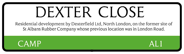
Part of the story of Camp Hill and the historical connection with the Camp refers to former military training. However, the field on the south side of Camp Road and historically part of Cunningham Hill Farm, was relinquished around 1912 when a rubber factory, on land at London Road and also owned by the Verulam family, was seriously damaged by fire. A replacement factory was established opposite the cottages at Camp Hill. Rubber processing was later moved to the factory estate at Porters Wood and the Camp Hill site became available for residential development under town planning rules.
On the site of the former Rubber Works is Dexter Close.

Perhaps references to previous occupation might have been transferred to the homes now on the site, but this being a private project the overall name comes to be known as Dexter Court. There is no local connection here however; Dexter appears because Dexterfield Limited is the name of a North London development company responsible for the project. The three blocks are separately named Gatcombe Court, Cheltenham Court and Dorchester Court. So, once more, no local connections that are obvious.

A private road off Sutton Road spent decades without a name plate and, if appears, without a name. On a large plot of ground between Hedley Road and Cambridge Road the land was acquired in the early 1930s for possible development for entertainment use as a skating rink. At the same time a similar centre was created at the former Ver Hotel site at the bottom of Holywell Hill. The council felt one skating rink was sufficient and the land was for a time used for commercial vehicle parking, including for Pickfords Removals vehicles. (Note: this fact has yet to be verified). Later, factories were attracted, and are still there, but since the access road is on private land a post war decision to name the road was made, presumably for postal and delivery reasons.

 |
| The former Co-operative Dairy vehicle maintenance works fronting onto Sutton Road. The road emerging in named Pickford Road serving other works buildings on the site of a proposed skating rink but then used for the storage of commercial vehicle. |
No comments:
Post a Comment