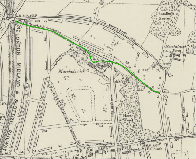
I thought I would spread my posts about East End streets around a wide area of St Albans' East End, and although I will return to Camp and Fleetville later, today you are in for a treat if you live in or around Marshalswick.
I know what you are thinking: you have no knowledge of a street known as New Road. Which is fine because there is no such named road today. Mind you, there is no such road as Woodlands Avenue or Kingshill Crescent, but that's another story.
Delve back two hundred years or so, and if you were a member of the Marten family living in a fine house north of Sandpit Lane – which also no longer exists – you might have been worried by nuisance passers by; that is, an ordinary member of the public wishing to take a cart, or make a walk, northwards and knowing the Marten family have a driveway leaving Sandpit Lane towards the front of their Marshalls Wick House, they might use it until they reached The House, but then join the continuation of that same drive towards the top of Deadwoman's Hill (more on that shortly), they would avoid toll payments on the turnpike roads leading to and from St Albans.By the 1840s John Robert Marten considered The Public making use of his private drive a nuisance, or perhaps an irritation to his family's right to a private life. He had clearly considered it to be a problem which he saw he had a responsibility to solve; permitting public use of the first section of the drive but then arranging for a diversionary route further from The House which the public could use. The Martens owned much of the land on which he would create his diversion, but needed to acquire a strip of land nearer to the higher Sandridge Road (Deadwoman's Hill) end. I am sure there is an explanation to the strange road name, which today is the steeper part of the hill from the railway bridge towards Sandridge. It was this name which was used in one of the earliest issues of the Herts Advertiser to announce the building of the new road (New Road)!
To ensure The Public kept to the public road he had two lodges built. One close to Deadwoman's Hill – we know it now as North Lodge – and the other where the Drive joins a lane. This is called South Lodge.
Mr Marten may have used casual or permanent labourers from his farms on the estate, but I am not certain how the construction was managed. Neither am I aware of any later reconstruction taking place if the standard of work was not sufficiently good. We are informed the work was completed in about a year between 1854 and 1855, and from the lane as it remained in the 1950s the road probably allowed for two carts to pass.
How long New Road remained under this name is uncertain, but it received its present label by the 1897 ordnance survey. Maps have also appeared without a name, probably indicating the cartographer remained uncertain.
But it strikes me as odd that the South Lodge was constructed so as to be to the east of the New Road rather than to the west of it. For it certainly was not between The Drive and the New Road. We may never know any subsequent implication from making that decision.
I will be meeting members of Marshalswick North Residents' Association on 11th April at 7.30pm, where New Road might be mentioned! I will feature any relevant topics which we discuss at the Marshalswick Community Centre in a blog shortly after.


No comments:
Post a Comment