Tuesday, 26 March 2024

Chain Bar Toll

 References to Turnpike toll gates can be found in the first volume of St Albans' Own East End and on its website, although information about some of them and their houses are rather sketchy, including what they actually looked like.  When travelling along the Hatfield Road from St Albans towards Hatfield travellers first encountered a gate at the Peacock PH opposite the present Marlborough Road.  This was the start of the St Albans to Hatfield section of the Reading & Hatfield Turnpike.  The price paid for travelling took you as far as Smallford at the crossroads (now a roundabout).  But on the way the traveller would have passed three toll points of interest to those travellers wishing to take themselves, animals or carts from a side road onto the turnpike Road and onwards towards St Albans.  All three were on the right: Camp Lane, The Rats' Castle and Colney Heath Lane; none was on the left.

Because the borough boundary just reached this point east of the town we are fortunate to
capture Hatfield Road curving between left and right; Camp Lane joins it from lower
right.  Ninedells Nursery was soon to be replaced by the Cavendish estate. The Granville
estate hasn't emerged either and the space at the top is still the Fete Field, predating
Clarence Park.  Town map 1878.
COURTESY NATIONAL LIBRARY OF SCOTLAND

Close-up of the turnpike toll point (TP on the map above).  Soon after 1878 plans would be laid for
the Crown Hotel and the emergence of Stanhope Road.
COURTESY NATIONAL LIBRARY OF SCOTLAND

The purpose of these little side road tolls, as they were termed, was to ensure payment was made before venturing onto the main road.  It would have been impractical for all side roads to be protected.  They were placed where traffic was busiest and there it would have been financially worthwhile charging for the shorter distances before a user reached the next main road gate.  After all, the cost of maintaining the main roads was borne by those using them, not by local authorities, before the 1880s.

The side road toll building we seem to know least about – no drawing, no painting, no photographic image, and no description – is the one where Camp Lane met Hatfield Road.  The nearest landmark was St Peter's Farm, part of which, today the Conservative Club occupies.  In fact I am not quite correct, for there are two known facts: tolls were collected only in the direction of St Albans; and it had three known names, the Chain Bar Toll, Hatfield Road Field toll, and the Fete Field toll.  Early 25 inch maps do mark the location with a tiny black square, but that square could represent anything.

This Ordnance Survey 25 inch map from 1897 covers the same area. Camp Lane had been made
up and renamed Camp Road; Stanhope Road has replaced the toll house opposite the Crown
Hotel; Clarence Park and Clarence Road is now on the scene, and the triangle of land, 
informally called The Green will shortly be built on.  The pond is not, however, shown.
COURTESY NATIONAL LIBRARY OF SCOTLAND

However, the National Library of Scotland collection of Ordnance Survey maps does include a small number of Town Maps, and right on the eastern edge of the borough, extending as far as St Peter's Farm at today's The Crown, and standing on its own, is the toll house; a bold rectangle with a smaller attachment at the back.  It is likely to have been a single storey structure; that assumption being on the basis that one of the toll keepers had accommodation at the cottage next to St Peter's Farm house.

Much change occurred during the twenty years since the 1878 town map was surveyed and the opening of Clarence Park in 1894. In the south-east corner was Ninedells Nursery soon to be sold to Frederick Sander for his housing and orchid nurseries.  A little drive enters from the Hatfield road onto the Ninedells; this became the line of Albion Road and Cecil Road as the new houses of the Cavendish estate were build.
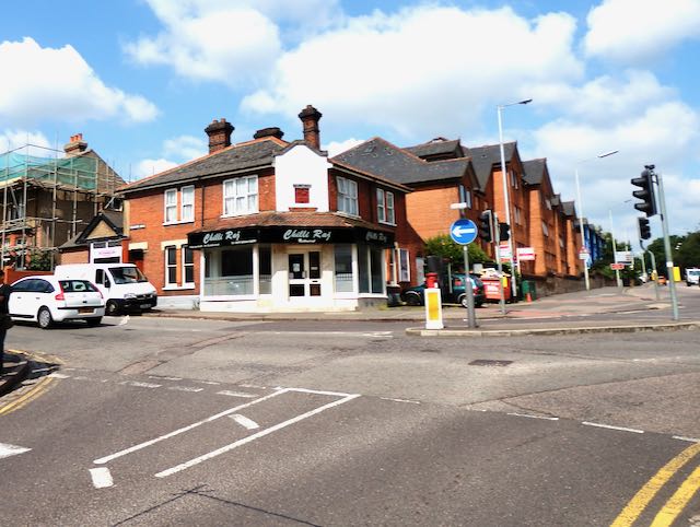
The toll house was just to the right of the two white vehicles at the beginning of Stanhope Road.
Camp Road is shown joining Hatfield Road ahead.

The pond has now been replaced by the first two shops on the left, opposite Albion Road, formerly 
a track access to Ninedells Nursery.
COURTESY GOOGLE STREETVIEW


The access to the Ninedells Nursery extended to include the present day Cecil Road.
COURTESY GOOGLE STREETVIEW

Clarence Road was designed to meet the former toll house junction.  A form of roundabout
enabled vehicles to use a road directly in front of the hotel to access the new Stanhope Road.  So,
not a proper roundabout!
COURTESY GOOGLE STREETVIEW

In the north-west a track left the Hatfield road, crossing the Fete Field diagonally towards the farm barns.  Much of this field quickly became the recreation field of Clarence Park, but the location of the track can still be located along the park's Hatfield Road boundary, opposite the Granville Road junction.

From inside the recreation section of Clarence Park the former entrance from Hatfield Road,
opposite Granville Road, can still be located; the gate and ramp down to the path was still
open until the 1960s.  Although this image was taken some ten years ago the foliage is still
not as dense as other sections of the tree screen along the road.


The largest single change is the laying of Clarence Road, designed to leave Hatfield Road from the bend at what was intended to be a form of roundabout, and the pond shown on the town map has now been replaced by the first two shops, 41 and 43 Hatfield Road.

An early newspaper report described the development which took place in Hatfield Road Field (the south-west sector of the town map). It stated that the shop, now Chilli Raj, which was built as a general store and post office, replaced a former toll house.  The map evidence shows this not to be quite true.  Its location appears to be on the line of Stanhope Road, which would have been a few years before the building of the little post office.  Standing along the approach roads in turn leading to The Crown junction it is still possible to follow the various map lines edging the roads and tracks shown on the 1878 Town Map.


Tuesday, 19 March 2024

New Road

 I thought I would spread my posts about East End streets around a wide area of St Albans' East End, and although I will return to Camp and Fleetville later, today you are in for a treat if you live in or around Marshalswick.

I know what you are thinking: you have no knowledge of a street known as New Road.  Which is fine because there is no such named road today.  Mind you, there is no such road as Woodlands Avenue or Kingshill Crescent, but that's another story.

Unfortunately I could find no suitable map for a period before 1875.  The green coloured drive, 
both light and darker, was the private drive to Marshalls Wick House until 1855. John R
Marten had the orange coloured road (now Marshalswick Lane) but initially called New Road.
In 1855 the light green section and New Road became a publicly available road.
COURTESY NATIONAL LIBRARY OF SCOTLAND


Delve back two hundred years or so, and if you were a member of the Marten family living in a fine house north of Sandpit Lane – which also no longer exists – you might have been worried by nuisance passers by; that is, an ordinary member of the public wishing to take a cart, or make a walk, northwards and knowing the Marten family have a driveway leaving Sandpit Lane towards the front of their Marshalls Wick House, they might use it until they reached The House, but then join the continuation of that same drive towards the top of Deadwoman's Hill (more on that shortly), they would avoid toll payments on the turnpike roads leading to and from St Albans.

Ahead is the southern end of the former New Road, the drive to the former Marshalls Wick House
now Marshals Drive, on the left, and Jersey Lane to the right. The original South Lodge is
just beyond the Jersey Lane junction on the right.
COURTESY GOOGLE STREETVIEW

The original North Lodge, now partly hidden by undergrowth. From its windows on the other
side users of The Drive could be seen on their way to or from Sandridge Road or 
Deadwoman's Hill.  From 1855 onwards users of the New Road were visible from this
side of North Lodge.
COURTESY GOOGLE STREETVIEW


By the 1840s John Robert Marten considered The Public making use of his private drive a nuisance, or perhaps an irritation to his family's  right to a private life.  He had clearly considered it to be a problem which he saw he had a responsibility to solve; permitting public use of the first section of the drive but then arranging for a diversionary route further from The House which the public could use.  The Martens owned much of the land on which he would create his diversion, but needed to acquire a strip of land nearer to the higher Sandridge Road (Deadwoman's Hill) end.  I am sure there is an explanation to the strange road name, which today is the steeper part of the hill from the railway bridge towards Sandridge.  It was this name which was used in one of the earliest issues of the Herts Advertiser to announce the building of the new road (New Road)!

To ensure The Public kept to the public road he had two lodges built.  One close to Deadwoman's Hill – we know it now as North Lodge – and the other where the Drive joins a lane.  This is called South Lodge.

Mr Marten may have used casual or permanent labourers from his farms on the estate, but I am not certain how the construction was managed.  Neither am I aware of any later reconstruction taking place if the standard of work was not sufficiently good. We are informed the work was completed in about a year between 1854 and 1855, and from the lane as it remained in the 1950s the road probably allowed for two carts to pass.


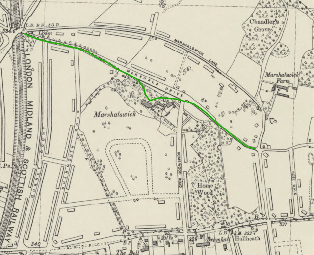
The 1939 map shows the long lines of housing along Marshalswick Lane and Marshals Drive.
The green line identifies the former Drive to the House, part of which had recently been
re-aligned to form the modern Marshals Drive.
    COURTESY NATIONAL LIBRARY OF SCOTLAND


Today we know this road as Marshalswick Lane, of course, but it hasn't always been so.  The first occasion it was committed to a map it was named The New Road, although I am not now able to trace that map.  I am uncertain whether the name included the short section between Sandpit Lane and what we know today as Jersey Lane, or whether originally it was accepted to be the outer end of The Drive.  Where roads are long and the road name is only printed once, that printing is usually somewhere around the middle of the length.  We are left to decide for ourselves where a road name begins or ends.

How long New Road remained under this name is uncertain, but it received its present label by the 1897 ordnance survey.  Maps have also appeared without a name, probably indicating the cartographer remained uncertain.

But it strikes me as odd that the South Lodge was constructed so as to be to the east of the New Road rather than to the west of it.  For it certainly was not between The Drive and the New Road.  We may never know any subsequent implication from making that decision.

I will be meeting members of Marshalswick North Residents' Association on 11th April at 7.30pm, where New Road might be mentioned!  I will feature any relevant topics which we discuss at the Marshalswick Community Centre in a blog shortly after.

Thursday, 14 March 2024

Cell Barnes Lane


Updated 15 March 2024


 Lanes give the impression of  being narrow rural roads, often bordered by hedging and maybe trees – or if not, fencing. In addition, they come with unexpected single or double bends, some providing a clue to earlier deviations.  An occasional cottage, barn or farm entrance might also turn up.


Camp Road and Camp Hill are near the top of this 1875 map.  Cell Barnes
Lane follows the green line past Cunningham Hill Farm towards the 
bottom right edge, to be continued on the extract below.
COURTESY NATIONAL LIBRARY OF SCOTLAND


Cell Barnes Lane continues toward Little Cell Barnes on the map surveyed
in 1875.
COURTESY NATIONAL LIBRARY OF SCOTLAND

At Camp Road's Camp Hill exists a T junction which is the beginning of Cell Barnes Lane.  It begins close to the former Cunningham Hill Farm, meandering gently downhill and finishing at the former Little Cell Barnes, although it continues at the charmingly named Nightingale Lane and once fed into the eastern side (or end) of London Colney; although today the four lane bypass gets in the way!

BY THE 1897 survey the first two properties, twin cottages lie to the side of the double bend,
very close to today's Drakes Drive.
COURTESY NATIONAL LIBRARY OF SCOTLAND


By 1937 the Springfield houses are completed, wrapping around Camp Road into Cell Barnes Lane.
COURTESY NATIONAL LIBRARY OF SCOTLAND

The complex of paths, lanes and other diversions north of Cunningham Hill Farm is a puzzle all by itself, which I will explore on another occasion, but until the post World War One period only two attached cottages appeared along the Lane in the 1880s.  Before that time it was  just the above mentioned farms.  The cottages were at a double bend in the Lane, and there are folk still around who recall the double bend as posing regular risks to cyclists, motorists and pedestrians from unseen lane users beyond.

The first major incursion of homes along the Lane occurred in the 1920s when a St Albans City Council post-war housing scheme (Homes for Heroes) was progressed in the mid decade  and named Springfield, after the field on which the homes were built.  Today a few of them have been demolished and replaced by the more modern houses on the Wingate Way estate. Spare ground before that development had been used as a cycle speedway track by various clubs in the district.

Programme produced by the St Albans EAC Hawkes Cycle Speedway club, with a photo
taken at the Cell Barnes Lane track (on the left page).
COURTESY BILL GADSBY

Little Cell Barnes cottages near what was the double bend, now between the two
roundabouts in Drakes Drive.


An early aerial photo of part of the London Road estate taken in the 1950s.
Cell Barnes Lane is shown diagonally from top right
to lower left.  Drakes Drive curves gently across the lower portion of the photograph.
COURTESY THE HERTS ADVERTISER


The next arrival in the 1930s was a major piece of infrastructure – the electricity grid was developing.  A new power station had been built at Hoddesdon and one of its circuits provided, via overhead lines, a supply to St Albans, with a substation in what was then open ground along Cell Barnes Lane.  Today it is opposite the Cunningham Schools. A field northwest of the sub-station and acquired by the council became the default location of circus visits once they could no longer make use of land at the Breakspear estate (the Gaol Field). The earliest maps show a copse of trees and a pond adjacent to Cell Barnes Lane.  This was lost on the expansion of the sub-station.

The site of the two schools, infant and junior, are both post-war and partly occupy an earlier sports field rented by O W Peak, the factory which made coats in Hatfield Road.  A pavilion occupied the site which mainly served tennis courts used by the firm's employees.

St Luke's Church's permanent home.


Electricity for St Albans arrives at the Cell Barnes Lane sub-station, originally coming from a new power station at Hoddesdon in east Herts.


Almost all of the former farm land between Cell Barnes Lane and Camp Road was acquired by the council and held in reserve for future housing – the London Road Estate.  Meanwhile it became one of the city's largest allotment grounds, the hedges on both sides of the Lane being rich in blackberries and sloes. Much of the land to the southeast of Cell Barnes Lane had, until the houses arrived, been row upon row of chicken coops belonging to Little Cell Barnes.

When housebuilding began in earnest from the 1950s it included the laying of Drakes Drive and a re-arrangement of Cell Barnes Lane at the double bend which provided the opportunity for introducing new junctions, eventually becoming little roundabouts.

Alongside the housebuilding grew the inevitable parade of shops, the Cornerstone Church, a branch library (the only one of the three on the east side of the city still remaining being at Marshalswick).  And we should not forget the permeant building of St Luke's Church, having moved from its temporary location in Camp Road and originally being a daughter church of St Paul's in Blandford Road.

This, and the one below, are the same extracts but current surveys.
BOTH COURTESY OPEN STREET MAP CONTRIBUTORS


So, during the period of just over one hundred years a quiet rural lane has become a busy residential road – with a pedestrian crossing and a bus route thrown in.