Sunday, 26 March 2017

Converting industrial measures

There was a time when you could, more or less, put up a factory or a workshop anywhere you wanted, wherever you had acquired a suitable piece of land.  There was no green belt, no considerations of whether an industrial building was, or was not, appropriate in a conservation area – no conservation areas anyway.  It is only since the advent of the Town & Country Planning Legislation that local authorities were given the powers to zone activities; and, gradually, most of the industrial sites in the East End, and of course in the city centre, were zoned for residential occupation (or retail in the case of the central streets).

Porters Wood industry
This gave rise to locations, mainly in the outer districts, specifically for industry to grow and flourish, although office accommodation was treated more flexibly and can be found widely around St Albans.

Porters Wood had originally been purchased by the City Council for the purpose of creating a new cemetery, but instead became an industrial estate, and has expanded considerably into Soothill Spring in recent decades.  However, access to it, especially for large vehicles, is not brilliant.
Brick Knoll Park, Ashley Road

Butterwick Wood had already become occupied by the odd industrial concern even before it was designated for industry, and early arrivals included J Pearce Recycling, to join the meat store, timber yard and Tractor Shafts.  Then, of course, came Ronnie Lyon and his serviced estates, followed by car showrooms and retail warehouses, and more recently churches and a recent attempt at leisure activity, all attracted by lower land costs, easier access and free parking.

Ashley Road had been a large brickworks before the Second World War.  Many years were spent filling in pits; meanwhile Post Office Telephones moved onto stable land where a former entrance and brick company buildings had been.  Early factories included heavyweights such as St Albans Concrete, piledriving operations and plant machinery hire.  Later these gave way to light engineering,  Polaroid photography, Royal Mail distribution and car servicing.

Lyon Way
At the Camp Road end of Campfield Road – Camp Fields on a 19th century map – the original 1900s concerns of the Salvation Army, Sphere Engineering and the Electricity Works survive as a smaller commercial area, later joined by the Herts Advertiser, now offices.

We were alerted recently to the concerns raised by the District Council.  There have been an increasing number of planning applications


for change of use from office to residential – and, if observational evidence is anything to go by, from industrial to retail and community.  The council is considering whether to apply for powers to allow it to refuse such permissions.

Small businesses at The Courtyard near Acrewood Way
To maintain thriving communities there should be an adequate supply of land for commercial and industrial activities, just as there should be for housing.  We have a buoyant commercial sector in St Albans, but shortage of space pushes up the price.  This will eventually see developers searching industrial estates for office opportunities, which will, in turn reduce industrial capacity.

The years have gone when most people walked to their place of work and often rented their home accordingly, but there continues to be sense in not requiring most of the population to criss-cross each other in their cars as our employment takes us to other towns.

My grandfather lived in Camp Road and walked down the hill to the Salvation Army works; my father lived on the Beaumonts estate and walked to work in Hatfield Road; I had two jobs which were local in the same way, enabling me to cycle to one and walk to the other.  We should applaud the Council for its attempts to keep our local economy balanced.  Article 4, whatever that specifically is, will free the authority from having one arm tied behind its collective back.

Sunday, 19 March 2017

Patching Up the Past

Recently there has been good success in re-visiting one of St Albans' Own East End's unanswered questions: the mysterious golf course between Smallford and Hatfield.  Two recent blogs demonstrate what was discovered.

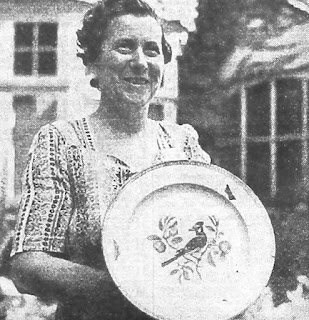
This week is the turn of a largely forgotten exchange scheme which came about at the end of the Second World War.  Raised as an idea by Mr Thomas Slade, the St Albans – Duisburg Relief Committee was launched; the reasons became clear from a Herts Advertiser article in 1948: "It is almost impossible to describe the conditions in the Ruhr.  There is nothing to compare it with ... there are still 2,000 people living in cellars beneath collapsed houses, and more than 1,800 others, including many children, still exist in public air-raid shelters ..."

Vera Robson on her return from the delegation's first visit to
Duisburg, with a presentation plate given by that city.
COURTESY HERTS ADVERTISER
A delegation from the city visited Duisburg (population then 400,000) to assess how help might be given.  Regular shipments of clothes, blankets and food were sent.  In the other  direction small groups of children and young people arrived in St Albans for extended 3-month holidays and stayed with families, many of them in the eastern districts such as Fleetville, Beaumonts and Marshalswick.

In a further development during the 1960s and 70s an exchange scheme developed with St Albans young people visiting the homes of Duisburg families.

I was one of those young people in 1963 and 1966, and an official West German newspaper (as the country was then known) photographer took the group picture at the Duisburg Town Hall in 1966.  Among the assembled group at the Welcome ceremony were David Walker,  Peter Osborn, Michael and Barrie Gibbs, and Vera Robson.  During that year we had the interesting opportunity of watching the Football World Cup, played at Wembley, from one of many living rooms with our host families in Duisburg.  For those who need reminding, England won, and for us it was a lesson in magnanimity.

Welcome to St Albans guests in Duisburg Town Hall, 1966.

Eberhard, whose parents
welcomed me in 1966.
There will still be current or former residents of St Albans who remember these visits.  We may have found them great fun, or considered them a nervous process to encounter.  We may have learned much about our "adopted" friends and their families and an industrial city with its factory-lined river even larger than the Thames.  Almost certainly we will have learned much about ourselves.  Making some of the earliest holiday arrivals to St Albans welcome and helping them to relax in new surroundings must still be in the minds of several of us.

There is, regrettably, such a limited record of what was a generational project.  Our recollections would be a valuable resource.  Photos would enrich the experience.  If you were involved in any way, do please get in touch – saoee@me.com

Sunday, 12 March 2017

No time for a round

Recently I brought to the top of the proverbial pile a so far unanswered question about an alleged golf course between Smallford and Hatfield.  Apart from being taken off the scent by the mis-naming of St Albans Road West as Hatfield Road, there did not appear to be anyone with further information.  Until, that is, a reader discovered a website devoted to former golf courses (Golf's Missing Links).

Great Nast Hyde.  Courtesy HALS
The brief text identified it as Nast Hyde Golf Club.  I guess the text originally came from a golfing yearbook of 1910. "...the opening of a new railway station about a mile from Hatfield, on 1st February.  The station had been built to serve a fine new residential site, and among other features will be an eighteen hole golf course.  In 1914 the Secretary was Colonel Schreiber and the professional E Gow.  An eighteen-hole undulating course on good turf, well drained on gravel soil. Subs for gents were £3.3.0 (£3.15) and for ladies £1.1.0 (£1.05).  Visitors' fees were 1/- (5p) at any time."

Very promising.  It seems from the above information that during the period  to 1914 the course was in development; hence the identification of nearby residents as workers on the golf course in the 1911 census.  The course, and the houses (of which very few now remain) were part of an attempted sale of land at Great Nast Hyde as early as 1889.  The manor house was also a working farm, separate from Little Nast Hyde Farm, and the estate included land on both sides of St Albans Road, including Beech Farm.

Golf course site circled.  Courtesy Google Maps
Eventually, over a decade, some thirty homes were erected, but it was clear that many more were anticipated.  By 1914, as soon as the golf course had opened, the dark clouds of war approached and large numbers of men volunteered or were later conscripted for military service, and were therefore lost to the local community and its trades.

 A further attempt to sell 441 acres of Nast Hyde Estate was made in 1925 by Foster & Cranfield London EC, including what had been the formative golf course, now clearly identified as 36 acres between Coopers Green Lane and St Albans Road West, immediately south of a block of woodland with shooting rights, known as Home Covert.  The 1925 estate sale brochure gave the option to re-open the former golf course, or to develop.  In the words of the brochure: "eminently suitable for the erection of medium-sized detached houses or bungalows, for which there is a great demand as very little building has been carried out in the district for some years past."  On the bulk of the land available north of St Albans Road, I think it is fair to say not a single additional house was built.  The intervention of aeronautical activity at this time is quite another story.

South of St Albans Road West it was a different story.  Although it took a further five years, two fields were developed as the Selwyn and Poplar estates, only part of the latter having been completed before the onset of the Second World War.  Oh, and the part of the 1927-built Barnet Bypass between the Roehyde Interchange and The Comet is on former Nast Hyde land purchased at the time.

Well, in spite of everything, the land which had just about become a golf course, is still undeveloped.  It is within the boundary of Ellenbrook Fields, the country park which has yet to be officially created – look forward to some gravel extraction first, maybe – so there may yet be the opportunity for a golf course, though perhaps not 18 holes.  It may even sport the title Nast Hyde Golf Course.  Speculation!

Sunday, 5 March 2017

View From the Boundary

On any walk through Clarence Park, from York Road towards the ornamental park, our eyes might be focused on an ongoing cricket match, in which case our interest is concentrated on the middle ground.  When the outfield and crease is quiet it is the pavilion which dominates.


A view of the pavilion when new – you won't find the clock in this
picture!  Courtesy St Albans Museums.
We have known this view since our first visit; whether it was five or fifty years ago the pavilion seems not to have changed.  Its sturdy red, decorated brickwork, especially visible from the rear elevation, gives the impression it would stand for ever.  The woodwork sometimes gives us our first impression that all is not well with the structure.

The pavilion is, of course, a District Council property leased jointly to St Albans Cricket Club and St Albans Hockey Club; at least that was the arrangement until recent years, when the Hockey Club migrated to facilities elsewhere.  Which left the cricket club to shoulder the financial burden on its own.

In a recent message via the Protect Clarence Park group, St Albans Cricket Club representative Paul Sands stated, "For many years the bar and social areas in our beautiful and historic pavilion at Clarence Park have been unloved and uncared for and we recognise that it is currently not a particularly attractive place to spend any amount of time. We understand that the bar really ought to be an important revenue driver for our club and should provide a comfortable and welcoming environment for teams and members to spend time together. We know , that with some thought, time and resources we can make the bar and the long room  somewhere we can be proud of. "

The club has a long-term vision of operating the pavilion as a social enterprise, to ensure the facilities within the pavilion are used effectively and appropriately, with the aim of running the building sustainably.

Meanwhile, rather more urgent work is required, which, when broken down into manageable chunks, is an ideal opportunity for volunteers.  Replacing the flooring, furniture, worn out fixtures and lighting, and providing a fresh coat or two of paint.

Paul Sands continued
, "We want to create a friendly and inviting space that members, their friends and their families will want to spend time in and that third parties might want to hire for events, thus bringing in much needed income for the club. The bar is also used by the families of our junior members particularly during Friday evening training sessions throughout the summer at Clarence Park. We would like it to be a nicer environment for them too."

The club is therefore sending the call out for volunteers experienced as builders, electricians, plumbers and other skilled tradesmen.  And then volunteers who are not necessarily skilled but can undertake tasks with a smile, and generally assist.  It sounds very much as if destruction is one key element, given that the word sledge-hammer is one tool mentioned (and how many different uses for a screwdriver can you think of?), as well as more calming tasks with a paint brush.

The third requirement is money, naturally.  The club is busy devising methods of raising funds to undertake the purchase of materials.  Meanwhile, it has opened a Just Giving web page,  www.justgiving.com/crowdfunding/stalbanscc


To offer your service in this project (and your smile) contact Paul Sands on 07540 705966 or paul.sands2@gmail.com


Inside Clarence Park, which we all consider "ours" with pride, will soon be a volunteer group creating a new community facility in that friendly structure which gives an impressive View From the Boundary.


Sunday, 26 February 2017

Junction by design?

The country end of Sweetbriar Lane!
During the Second World War it was deemed essential by someone in charge that the road junction at The Crown should be protected by road blocks.  It is likely that wardens and guards queued to volunteer for this duty as their mess was The Crown Hotel.  The records at Hertfordshire Archives specified the number of yards from the junction a road block was to be set up.  They do not specify exactly what kind of block, but possibly concrete blocks and iron bars.  They were to be set up in Stanhope Road, Clarence Road and the two arms of Hatfield Road.  The block on the eastern arm just east of Albion Road.  So, that just leaves Camp Road, which apparently had no road block at all, but no explanation was given.  Of course, any alien vehicle driver with a map could turn into Cavendish Road and exit Cecil Road and thereby avoid the block altogether – but that would depend on what they were up to!

Stanhope Road meets The Crown.
A strategic junction The Crown may have been, but no-one in their right minds would have designed a junction this way.  It is rather a mess.  So let's explore how it came to be.  Hatfield Road from the east drops down a little hill (possible sign of a former stream valley) before bending to the right en-route towards St Peter's Church; but other than climbing out of the little valley there was no long climb to the bridge as there is today; that was a construct of the railway.

At the bend arrived a backwater lane which for centuries had wound its way past hamlets and villages, supporting the tiny rural population needing access to the town market and its parish church.  In the 1750s a small toll house appeared at the junction, roughly where the postbox is today.  Travellers from now on would be entering and using a privately run highway, a turnpike road.  Inevitably it did not take long for a few travellers with carts or animals to find ways around the problem, avoiding the junction, possibly with the agreement of the landowner, or possibly not.

A roundabout of sorts at The Crown.
Courtesy St Albans' Museums
By the time the next road to be added to the junction came about, the "illegals" – travellers avoiding payment, had become used to picking their way and making an entry to the town where a little lane, known locally as Sweetbriar Lane, finally petered out.  Sweetbriar is now Victoria Street.

It probably wasn't surprising, therefore, that when the wedge of land we know as Stanhope and Granville roads was being developed a road connection between Hatfield Road and Victoria Street was created, with the junction just a few yards before the toll house!  By the time the road was laid, however, the turnpiked Hatfield Road was taken over by the Highways Board and the tolls dispensed with.  Drive today from Hatfield Road east, turn left and then sharp right into Stanhope Road, and then imagine trying the same manoeuvre with larger carts or carriages with two or even four horses.  Not surprising, therefore, that a new roadway sprang up (still there today) to leave Hatfield Road obliquely, and in front of The Crown Hotel (the road was there first; The Crown arrived later).  All of which created a little crossroads.  Not much of a problem before homes began to appear, but it's not surprising that the little road in front of The Crown was eventually closed, although it was useful in creating an informal roundabout at one stage.

The park once included all of this street area; at least the
building of the toilets opened up a view for motorists
looking right.  Courtesy St Albans' Museums
The last road to join the junction was Clarence Road.  Not a road at all before the 1890s and the opening of the park; the opening went just  as far as the present park gates, its purpose being to give access to the farm buildings (now Clarence Park Mews and the Conservative Club).  Once houses were built, though, you probably wouldn't want to drive to the Crown Junction and risk easing out without knowing what was coming down the hill from the right.  Until the early 1930s the park fences, shrubs and trees came right down to the corner, until the park was cut right back when the public toilets (now Verdi's) were built in the early 1930s.

As you see, rather a messy junction.


Saturday, 18 February 2017

Updating and refreshing

We do it to our homes; we do it with our cars and our wardrobes.  Every so often we also do it with our websites.  Give them a refresh; an improved way to display information on the pages; and more efficient links both to other pages and to other sites.

That is exactly what is happening to www.stalbansowneastend.co.uk during February.  If you have browsed the site recently you will have noticed a mix of the old and the new – and even the new may receive further tweaks during the next few weeks.

In fact, there new topics which should be appearing this Spring, which have never received much attention, yet deserve to.  More news of these at a later date.

There is one page which I return to regularly, mulling over a few of the questions which have been asked by others, or, in an attempt to complete some research or other, I throw out in the hope that solutions may be discovered by others.

For example, the 1911 census enumerates two families living at Horseshoes (now Smallford) and Ellenbrook.  In one household there were two boarders who were employed as a green keeper and golf labourer.  In the other household there were a golf professional and a horse driver at a golf club, which the census describes as the Hatfield Road Links.

The early development was on the right of St Albans Road
West, near The Comet.  Trees now hide where the homes
were.
The dawn of the 20th century was a period of building development along the road to Hatfield.  The grass air strip would shortly be laid on part of the former Harpsfield Hall Farm – Ellenbrook Fields occupies part of this land today.  A row of large detached and semi-detached homes began to line the airfield side of St Albans Road West from opposite Ellenbrook Lane as far as the access road to the police station opposite the Galleria.  Most of the homes didn't last long and none remains today.  Not even in the form of photographs that I have discovered.

The occupiers of these homes were in well-paid jobs: banking, accountancy and other City-based careers.  This was the clientele the developers were anticipating, and on the back of the promise of a large number of similar homes – the rest never materialised – persuaded the Great Northern Railway Company to construct a station at Nast Hyde for residents to make the connection at Hatfield for trains to the City.

The railway company agreed to add a station at Nast Hyde
close to the development. 
A golf club would  be a further social benefit to the residents and was likely to be the kind of facility provided by a developer.  The question, however, remains: where was this club?  We may be confused by the name used in the census: Hatfield Road Links.  If that is meant to be an accurate label of its location, the club had to be west of Smallford crossroads, for that is Hatfield Road.  Should we therefore be looking for a site at Butterwick Farm or Butterwick Wood?

The road becomes St Albans Road West at Wilkins Green, Nast Hyde and Ellenbrook.  Adjacent to the  garden centre was, between the wars, a speedway track, but surely that would have been too small a location for golf links.  Until de Havilland Aircraft Company moved onto the air strip site in the 1930s land not required for the strip would have continued in agricultural use, either Popefield or Harpsfield Hall farms.  But behind those detached homes, could the developer have rented or leased sufficient acres for golf use?  The income from thwacking small white balls around would have provided more profit than many field crops.  But financial success for the golf project would have depended on the developer completing his allocation of expensive homes.

The Selwyn estate was added in the 1930s to the early
unfinished development.
We now appreciate that the First World War intervened, and completion of the work only concluded when the smaller homes of the Selwyn estate arrived in the late 1930s, by which time the aircraft firm had put down roots.  Developers make many promises, but events often intervene and promises become failed dreams.

But a golf club was around St Albans Road west (or Hatfield Road) somewhere, and was in operation – at least four men were employed for the purpose.  So, in addition to discovering  where the club was, we should perhaps discover in whose employ the men were.

Sunday, 29 January 2017

Oh for a Bypass

Recently I posted about the cherished idea of a Circle Road, now the St Albans Ring Road, to take traffic away from the centre of the city.  As an idea in the 1920s it was innovative, but has since thrown up many concerns.

In the same period, following the end of the First World War, the government created a huge infrastructure programme to manage the expected increase in motoring, and to protect the historic heart of many of our towns and cities.  So, let's see what that meant in practice for St Albans.  The trunk roads from the county's towns to the north and east reached Hatfield and funnelled through busy Fleetville to the centre, squeezing through St Peter's Street and Chequer Street, leaving St Albans through developing Chiswell Green towards Watford.  Yes, we know that Fleetville appears even busier today.  Nevertheless, it was one of those planning issues that never seemed to go away: what to do about through traffic in St Albans.
Off-peak at London Colney Roundabout

By 1927 the A1 improvements, including the Barnet Bypass were complete between Stanborough and Hatfield, and two years later the Watford Bypass between Garston and the A41 North Watford was opened.  They were designed to a common standard with three-lane dual carriageways, 10-foot wide footpaths and a wide grass strip to carry pipes and cables.  Only one carriageway would be built initially.  Because the section of the strategic route, labelled the North Orbital Road, wasn't even begun around St Albans, the effect of wonderful new roads to the east and south funnelled even more traffic through our eastern suburbs.

When it finally arrived our brilliant new St Albans Bypass certainly made a statement.  No longer was it necessary to grunge through the ancient city, just as it had not been necessary to splutter head-to-tail through Hatfield or through St Albans Road in north Watford.  Fleetville immediately felt the benefit.

The bypass attracted two rather prosaically-named filling stations: the Humming Bird (at the Noke) and the Rainbow (near Colney Heath).  There were downsides, however, for those who lived nearby the new road or whose journeys needed to cross it.  At Colney Heath, White Horse Lane,  Napsbury Lane and Tippendell Lane there were simple cross-road junctions – only the Napsbury junction has been flown when the carriageway was dualled in the fifties.  For all of us still struggling with Colney Heath longabout it will be galling to discover that within two years of opening flyover junctions were planned for Colney Heath, and at Park Street (one of two junctions – the other being London Colney – provided with small roundabouts from the start).  Both flying junctions were cancelled as the funds dwindled.  Meanwhile, White Horse Lane was closed to traffic when that section of the bypass had its second carriageway added in the 1960s.

Park Street roundabout's original diamond junction has been widened but remains a challenge, especially on the Park Street side, and its throughput as been overwhelmed ever since the M10 was opened.  The other diamond junction, at London Colney, remained until plans for London Colney Bypass were put in place and London Road straightened.  The original road on both sides of the new and enlarged roundabout is still visible, but there is still a feeling of being cut off from St Albans when negotiating a journey from London Colney.

As with the Ring Road, the St Albans Bypass (North Orbital) – in planning the saviour of Fleetville's traffic problems and relief for the city centre – has always thrown up problems of its own, and now accommodates too many vehicles for its closely-spaced junctions to handle at peak times.  As Hatfield has expanded, as additional lorry movements from a new Smallford

gravel site are given the go-ahead, and whatever development is finally approved for the old Handley Page site, one issue will still be around: how to handle the traffic on the bypass.