Wednesday, 29 June 2016

The naming of where we are

I once was approached by a perplexed motorist near my Watford home. He was looking for a place near the motorway called Watford Gap.  He was crestfallen when informed he had a long journey ahead of him!

A rather similar puzzlement comes over people when they feel there is a simple answer to the question, where exactly is Fleetville.  It is a question I am often asked.  Of course, most inquirers do know where it is – on the east side of St Albans – but like all of us we cannot be sure where its boundaries lie.

As with most smaller towns St Albans has never placed the names of its suburbs along its main roads, although Watford at one time did.  Suburbs such as North Watford, Garston and Oxhey were announced as you approached them.  A few towns provide additional information on their street plates, usually on a coloured band, so that everyone knows exactly whether you are in one suburb or another.  Other authorities use the first part of a postcode, but these only loosely define where you are.


Let's return to Fleetville.  The name is not ancient, like Sopwell; nor was it named as a developing district, like New Greens.  It seemed, instead, to be named by a growing number of people who lived close to the Fleet Printing Works which had arrived in 1897.  At this point the new works were surrounded by fields.  To accommodate some of the key employees the factory owner had houses built opposite the works which collectively were referred to as Fleet Ville (the Fleet Village).  Fleet, in this instance, was derived from Thomas Smith's other factory site, just of Fleet Street, London.  Fleet-space-ville became Fleetville by common usage within a year or two.

The next issue is whether you can draw a reasonably accurate boundary around Fleetville.  St Albans City & District Council voting wards of Clarence and Ashley together include Fleetville, but they also spread further, so those sources are probably not helpful.  Few residents north of Brampton Road will tell you they live in Fleetville.  But they probably don't live in Marshalswick either.

Possibly more Camp residents ally themselves with Fleetville, but there is a permanent difference of opinion about where Fleetville ends and Camp begins, or perhaps Camp is a part of what could be called wider Fleetville.  How far must one walk west along Hatfield Road to leave Fleetville and enter – well where? – Crown perhaps.  In the easterly direction, does Fleetville merge into Oaklands, or is there something in between?  Beaumonts maybe.

Only in recent years have local direction signs appeared pointing the direction to places such as Fleetville and Quadrant.


Naming where we live is very personal, and there are countless examples of people refusing to add a name to their address for a reason which is valid for them, but maybe not for others.  A sizeable body of residents living in Twickenham still insist they live in Middlesex, though their borough, Richmond, replaced the ancient county name nearly half a century ago.

Fleetville Community Centre informs us that their area of benefit – the area they officially serve – is between Clarence Road and Colney Heath Lane, and from Sandpit Lane to Camp Road.  So that is another Fleetville.

Perhaps our blog readers can let us know whether or not they live in Fleetville.


Saturday, 25 June 2016

Smiles and whistles

Hertfordshire, and in particular St Albans, was in at the beginning of Scouting in 1908.  In fact, Hertfordshire is considered to be the first Scouting county in the world, given that so many facets of the organisation were tried out here before being taken up successfully elsewhere.

Although much has changed and there have been openings and closings of Groups (in the earliest days known as Patrols) throughout its history, including a few mergers, a number of extant groups have run continuously for all of scouting's history.  Among these we should acknowledge the 1st and the 4th St Albans.

There are groups who have opened quietly, especially during periods of scouting revival, and then become too small in number, or lacking leaders who were thin on the ground, that they equally quietly closed.

Those groups which attracted young people from the east end of St Albans included 2nd (Camp), 8th (Trinity/Camp Road), 9th (Sandpit Lane), 13th (Marshalswick), 15th (SS Alban & Stephen/Camp Road), 16th (St Paul's) and 18th (Homewood Road).

But there was another group, probably formed in the post-WW2 period, and closed by the 1990s.  That was the 12th St Albans (Cell Barnes) Group.  Little is now known about it, except for two events.

The first occurred in 1950.  The Herts Advertiser reported in July of that year that an 8-day camp was held in a field next to the Watford ByPass, for 11 Cubs, 12 Rovers and 28 other Scouts of the 12th St Albans (Cell Barnes) Group.  That is a camp of considerable size and therefore must reflect the success of the group at that time.

The book, Always a Scout, published in 1983, briefly mentions on page 41: “The 12th St Albans Group is attached to Cell Barnes Hospital.”  The use of the present tense suggests the group was extant at that date.  However, Cell Barnes Hospital had closed completely by 1998, so it is  assumed the group had also closed by  then.  

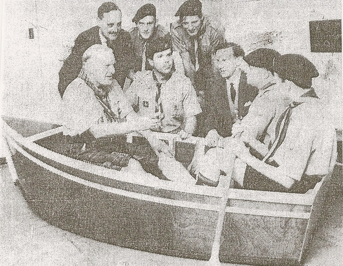
The second event was in 1965 when a number of the 12th scouts had created a small boat in the hospital's workshops.  The "three in the boat" are the County Scout Commissioner Melville Balsillie, and scouts John Sanders and and Anthony Spencer-Palmer.  Also featured are Tom McLean, Andrew Goldstone and David Polhill, scoutmaster and assistant scoutmasters of the 12th Group.


Dry land launch for the boat the 12th Scouts built.  COURTESY HERTS ADVERTISER

We know that the Scout Association has always urged that scouting is an inclusive organisation, and at the time this photo was taken Charles Cade was the Assistant County Commissioner for what were referred to as Handicapped Scouts.  It is likely that the group was begun by parents of youngsters who were part of the Cell Barnes family; this being a great way of enabling children to participate in fulfilling and active pursuits.  

The County Scout Archivist, Frank Brittain, has recently stated, "it is important that the presence of this scout troop is recorded in the history of the hospitals."  The hospitals in question are, of course, Hill End and Cell Barnes, both now closed.  But research into their respective histories is being carried out by trustees of Highfield Park Trust.

We would welcome contact with any former members of the former 12th St Albans Scouts, their supporting group of parents and friends, or former members of the Cell Barnes family, so that the life of this scout group can be recorded.  Members of the 12th, after all, "smiled and whistled*" as much as members of any other troop.

   [*This is a reference to part of the Scout Law which every member agrees to when joining the organisation.]

The usual contact address is saoee@me.com

Thursday, 9 June 2016

Over the tracks

OS 1924 map.
The Midland Railway is laid out on a broadly north-south alignment through St Albans, and when travelling the roads in and around the city we need to negotiate the railway.  Fortunately we do not suffer the constant noose of a level crossing, but we've always had bridges: over on the bypass, under at Cottonmill Lane and London Road, and over at Victoria Street, Hatfield Road, Sandpit Lane and the King William IV.

The over-bridges have all had improvements made at some time or other, and Sandpit Lane probably the most drastic of all, considering its original width.  The "Lane", in Sandpit Lane, gives us an image of a narrow rural cart lane with wastes on each side, partly wooded and partly hedged.  At the western end it descended from the town hill before climbing again onto Hall Heath and finally descending once more onto the wider plain east of Newgates.

The map illustrates that the line of the bridge, when constructed in the 1860s, still allowed for carts and pedestrians to continue along the original route while the work took place to build it.  The original alignment was then neglected once the bridge was opened for traffic and the work completed at railway level.

The bridge today.
The bridge was wide enough for two carts to pass.  After all, it was a country lane and vehicles and pedestrians had always shared the same space.  That is how it remained until a narrow footpath was added on one side in the 1950s.  In fact, the houses fronting Sandpit Lane at the end of Gurney Court Road still have their private footpath, because none was available on Sandpit Lane itself when the homes were first built in the 1930s.

As for the traffic itself, there was light movement until Marshalswick, Newgates and Jersey farms were developed, and more latterly the business and university traffic at Hatfield.  Most of the vehicles were cars or other light vehicles, and passing over the bridge was not an issue even if two opposing vehicles were passing.  Nevertheless add cyclists to this mix and a

Private footpath through the gate.
 further proposal for two full width footpaths,  and the potential issues mounted up.

The bridge was the responsibility of the railway and, after a century of use, bearing in mind it was designed as a rural light vehicle bridge, the structure required replacement.  Meanwhile, a weight limit was imposed, which had an immediate impact on heavy vehicles, including the double-deck 354 bus.

With the railway closed work continues to widen the bridge.
COURTESY ST ALBANS MUSEUMS
So, in 1968, work began on removing the old bridge and extending the ramp, which made the approach easier for pedestrians and cyclists, the only groups of users that were able to cross while the work proceeded.  Other traffic was diverted to nearby bridges, and finally a two lane roadway of full width, plus two footpaths, was available, with better sightlines at Lancaster Road, Lemsford Road (always an awkward junction) and Clarence Road.

The widened road extends over the original alignment of the
Lane.  View eastwards from the bridge deck.
COURTESY ST ALBANS MUSEUMS
It all seems such a long time ago – nearly fifty years – but in coping with today's traffic levels it reflects the gradual change from rural lane to urban radial road, and unofficial northern by-pass   for Fleetville.

Incidentally, if anyone has a photograph of the original Sandpit Lane bridge, do please email saoee@me.com


Sunday, 29 May 2016

Striking Camp

The Old Camp House at Camp Hill

We used to have a really enjoyable time at Scout camps.  New places to experience, new skills learned, bad old jokes we'd laugh ourselves silly over.  And if we didn't return home thoroughly dirty, nobody would believe we had actually been on camp.  That was true in another way too.  At the end of camp and the final campfire singalong, we would share in the task of striking camp, until there was nothing left of the site to prove we had been there, except the memories.

A thriving Camp PH
Soon that will be the case with The Camp public house.  Just the memories, and of course the photos. Not just the pictures of the demolition, but of the social events which were based there in its heyday of the 1920s and 30s.

The pub's beginning began a few hundred yards along the road in now-demolished premises in what had been ambiguously called, until 1914, the Old Camp (Beer) House – was it the Camp, the beer or the House which was old?  When McMullen's purchased it from Adey & White (who had acquired it from Thomas Kinder and who knows who before that) the building was in a decrepit state.  It was purchased by McMullen's specifically to have a license in place with which it could serve the new and growing Camp district.

Demolition begins.  COURTESY VIC FOSTER
Purchasing a portion of the Oaklands Dairy land a fine new building was erected.  Although the sign mistakenly assumed the name Camp referred to a Roman temporary settlement, the public house came to be a focus for the maturing district.  Even the library van pulled up on its courtyard each week.

However, the heyday came and went, and in recent years trade has limped along.  Given the distance to other pubs good organisation might have  re-invigorated good atmosphere once more and re-grow  a quality business.  Surely that would have been worth saving a fine building for.  A local group, though, did not stand a chance through the Community Asset route; there was just no time.

The machinery is on site, floorboards have been removed, presumably for onward sale, and gradually evidence for a century-old local pub will disappear.  It will, of course, require much more striking (of hammers and machines) than we did at other camps, but eventually there will be nothing left, nothing to remind us of its presence.

Arriving in its place will be a three-storey mass containing two dozen flats.  Should we be concerned?  About the loss of a quality building, yes.  Would it have been suitable for conversion?  Possibly.  About the loss of a location for people to meet?  Most definitely.  But there is a record of photos and of memories, so that is something.  Time moves on and we have to accept people need homes.  Perhaps, the new development will have a name which reflects its past in this place.  In such a  transition period the site will deserve that at least.  Any ideas to offer the development company?

What is coming?   Will there be a name?

Sunday, 22 May 2016

The Sand Pits Lane

The road which many car and van drivers make use of as an informal bypass from Hatfield Road was, until the 1960s, called Sandpit Lane continuously from Smallford crossroads to Stonecross.  Today the section from Smallford to Coopers Green Lane is Oaklands Lane.  But it seems to have been used as a bypass even before the 1930s, when the St Albans bypass (A414) was constructed.  And is being used for the same purpose today to avoid renewed congestion between Fleetville and the railway station.

Sandpit Lane Wastes between Clarence Road and
Sunderland Avenue.
We can probably trace the origin of Sandpit Lane back to Roman occupation, given that there was a minor road between Verulamium and Welwyn – this seems to follow the approximate line of the Lane – and there has been suggested occupation evidence even before the 19th century cottages on Hall Heath.

Hall Heath extends from The Dell, where there is an incline across broadly flat  topography, until a descent at Newgates, where Verulam School playing fields are located.  The Hall undoubtedly refers to a medieval manor house within a moat at Beaumonts (at the junction of Woodland and Central drives).

Sandpit Lane near Newgates.  Mid-19th century
painting by John Buckingham.
COURTESY ST ALBANS MUSEUMS
Before the 20th century only two structures existed between Sandridge New Town and the edge of town: the former railway bridge (not the version we drive over today) and the nearby cottage.  For almost the whole of its length between the clapboard cottages near Stonecross  and Hall Heath was – and still is for most of this distance – a landscape of 'wastes' on both sides of the track.  Effectively, these wastes were common land, which created difficulties for the owners of the first homes which were built, as there was no automatic right to drive vehicles across the wastes to reach the boundary of the homes.   In 1914 the Council, who managed the wastes, decided to carry out drainage works, which suggested there was seasonally excessive water standing across the lane.  Not surprising really, given that similar issues were prevalent along stretches of Hatfield Road, undoubtedly from the same chalk springs coming off the upper heathlands.

The lane was at its narrowest on Hall Heath itself as recently as the 1960s, where two vehicles could just pass on reaching Beaumont Avenue.  No footpath on the south side existed here either.  But at least the traffic frequency had been low until WW2 and pedestrians walking from Beaumont Avenue to visit The Wick could manage it in, perhaps, four or five steps, and could generally afford to amble.
Early 20th century at Hall Heath, but not much had
changed in the 1950s.

Today, congestion can occur anywhere from Woodstock Road North to House Lane, partly because the housing developments at Marshalswick, Newgates and Jersey Farm, but the attractiveness of the lane as a Fleetville bypass.  There is unlikely to be a solution on the horizon as several further housing developments are due to be launched in the next ten to fifteen years.  No-one has spoken of improvements to Hatfield Road, the ring road, or creating new diversionary roads, so presumably they won't happen either.
Newgates Cottages

Today there are traffic lights, pedestrian crossings and roundabouts, but otherwise Sandpit Lane is still attractive to walk along, if far more noisy than fifty years ago and with less clean air.  But we may be forced to accept highway improvements in the years to come, unless, of course, we all agree to drive less and cycle or walk more frequently.

Saturday, 14 May 2016

Off to the Stores

Herts Advertiser
advertisement 1932
At one time two department stores in St Albans provided its citizens with a wide range of merchandise.  They were Fisk's in High Street, and Green's in Chequer Street.  Neither is extant.  But many shoppers observed that neither trader was a true department store as each had a restricted number of sections.  Nevertheless, if you lived within striking distance of Hatfield Road, you walked to the nearest stop and boarded route 341 or 330 towards St Peter's Street for Fisks (later Blundells, Greens and all of the other city centre shops.

Then, in 1939, something excited householders.  A large store – a new department store – was due to open its doors in Welwyn Garden City.

The first 'Stores' at Bridge Road west, near Guessens Road.
To step back for a moment, Welwyn Garden City (the Second Garden City Company)  had been formed in 1919, and for the next 20 years the company largely concentrated on laying out roads and building houses.  Yet it understood that for potential residents to be attracted to the formative town, shops would have to be provided.  Initially this was in the form of a company shop.  Welwyn Stores (technically incorrect as Welwyn was a separate nearby town) was quick to open near Guessens Road and in a mainly temporary structure.  The first Stores provided most (though not all) domestic requirements for residents.  The company even opened small branch shops on the early estates.  There were, of course, the usual complaints about lack of competition affecting prices, and lack of choice within the premises.

However, all that changed in 1938 when the foundations were laid for a significant new structure on a prime site opposite The Campus (where the original building workmen's huts had been located), and in June 1939 the new Stores, now renamed Welwyn Department Stores, was opened.  Even if you've never heard of that name you will know the business from its current title as part of the John Lewis Partnership.

New Stores opens June 1939.
During the first week of July 1939 special bus services to the Stores were laid on from St Albans.  But it wasn't the best of times for new ventures: in another month World War Two would be declared, emergency wartime trading arrangements would gradually be put into place, and normal bus services would be curtailed.

Gradually, after 1945, when life returned to normal and bus services resumed at or beyond pre-war levels, the route 330 bus was carrying a steady stream of passengers from St Albans to Welwyn Garden City.  Our family was among those passengers.  On reaching the Comet Hotel, we passed The Stone House, picked up passengers from Birchwood, passed Jack Oldings, Stanborough, Lemsford Lane and Valley Road.  The bus travelled around The Campus, and if not going on to the Hospital, the  rather attractively-named destination Welwyn Garden City Cherry Tree was shown at the front of the bus.  The Cherry Tree was a restaurant, pub and music venue.

Post-war bus on 330 route outside
St Albans Bus Garage.
COURTESY MICHAEL ALLEN
Our visits always included some refreshment at the Parkway Restaurant on the first floor of the Stores (now it is The Place to Eat, but the original dance floor is no longer present).  We left the building at The Campus entrance, where the pillars are, and waited outside for the return bus to St Albans.

Clearly Welwyn Department Stores attracted many St Albans people away from the city's shops, and London Transport must have made a good profit, at least for a time, from its route 330.

Well, the two St Albans' department stores, are not part of the trading scene any more, but 'The Stores' in the form of John Lewis certainly is; and so is route 330, though today it starts from St Peter's Street instead of St Albans Bus Garage.  At the other end it finishes at Welwyn Garden City Station, which means Bus Station, which is opposite the former Cherry Tree, which is where Waitress now trades, which is owned by the John Lewis Partnership, which includes 'The Stores'.


Thursday, 28 April 2016

Our Engagement is Announced


An important event in the Fleetville district will take place on Saturday 7th May, and repeated at Larks on Fleetville Rec on Sunday 26th June.

After carrying out a condition survey in 2014, and assessing demand and the space available, the Trustees of Fleetville Community Centre agreed to proceed with their intention to replace the current building in Royal Road.  Not that it would be an easy decision to make, nor an inexpensive one.

In 2015 a preliminary proposal was made and discussions held with current user groups at the Centre.

Since 2012 the Government's Localism Act (2011) has enabled communities to take more control of community developments in their area.  This is a process which St Albans City & District Council has embraced, and the Community Centre Trust is working with the Council to enable improvements to be made to its site adjacent to Fleetville Rec.

Although being a long-term process, with the probability of no new building until the mid 2020s, all major projects have to start somewhere.  The Early Stage Engagement Event at Fleetville Community Centre will show visitors the history of the site and how it developed from wartime nursery to community centre, and on to the hoped-for next step.  Outline proposals will be explained – although it is far too early to show plans and drawings.  There is, of course, one important reason for this: it is not the function of the Trust to state what will be provided for the community, but the intention that members of the community will engage with the Trust, open a dialogue, and enable a new building to evolve which will meet the needs of residents.

Trustees will be on hand to engage in conversations and answer questions; and visitors will have an opportunity to suggest ideas and to express your opinion.  Information gleaned from the Early Stage Engagement event will be fed back to those who participated, and those who join in the Fleetville Community Centre New Build Project Facebook conversation.  Email info@fleetville.org.uk.  We will even add you to the mailing list if you post to this blog. The project's website can also be consulted: http://fleetvillesnewbuilding.my-free.website     Printed copies of the feedback will also be available from the Community Centre from mid-July.

Do take the opportunity to call in anytime between 10am and 5pm on Saturday 7th May, or while you are enjoying yourself at Larks in the Park on Fleetville Rec on Sunday 26th June, 12 noon to 5pm.