Saturday, 13 June 2015

Could we start again, please?

In 1914, as this photograph demonstrates, Hatfield Road has been much improved!  Not that we, in 2015, would appreciate that.  But considering that only fifteen years previously, this was a narrow lane, supposedly only wide enough for one cart to pass at a time.  So in that context, the road is certainly much improved.  After all, the County Council had kerbed and paved one side – the side where shops were opening up.  Not that many users were attempting to use the footpath; pedestrians were perambulating the full width of the roadway, and cyclists too.  Since everyone was travelling in the same direction, we may presume they are leaving the factories to make their way home.

Incidentally, the bushes on the left indicate that the shops east of Royal Road had yet to be built.

Fast forward another two decades and a second pavement will have been added, and motor traffic would have been sufficiently busy for an official parking zone to be created in Royal Road, and a bypass created between Ellenbrook and The Noke, via London Road and Watling Street, partly to relieve the congestion along Hatfield Road.

Bycullah Terrace in 1964
COURTESY ST ALBANS' MUSEUMS
During the forties the amount of traffic reduced considerably as severe petrol shortages kicked in and men were serving in the Forces.  It was during this period that young cyclists demonstrated their skills – or foolhardiness – by accelerating to the point where Andrew's, the greengrocer was, and still is, and freewheeling towards Sutton Road.  Naturally, what a waste of energy if you didn't actually do anything, and so little tricks were attempted, such as throwing out one's legs to the side, or drawing them up to the handlebars, carefully kneeling on the saddle, or taking one or more passengers over the rear wheel.  It was, naturally only a matter of time before accidents were had, but those who tried it must have thought it great fun.  Don't try this at home, or even in Hatfield Road!

From the sixties onwards parking became an increasing issue, the road was widened again, Sutton Road became busier after the former railway bridge deck was removed, and eventually the factory site which had been Ballito hosiery mills and Marconi Instruments, was developed as a retail centre.

The complexities of the road and its many junctions and access points now included light-controlled crossings and roundabouts – two of each in no more than three hundred metres.  Where, at one time, almost all of the children from the two schools would have walked to school, with or without their parents, now a significant proportion appear to be taken and collected by car.  Further, since most children attending the junior school on the south side, actually live on the north side, the crossings are well-used and help traffic to slow to a halt.

Which brings us to the latest improvement, added as a result of the Green Ring, which crosses Hatfield Road at the Post Office crossing, is a 20 mph limit zone from Morrison's roundabout to the Emporium.  I am sure this is useful at quiet times, but it is possible that travelling above this limit is pretty-well impossible anyway at the busiest hours of the day.  If only we could start again in designing Hatfield Road, Fleetville ...  No, no, no, let's not even think about it.  Nobody likes change. Except that, check the photo again; isn't that just what has happened, a great deal of change.

Further along Hatfield Road is a temporary yellow sign announcing Street Lighting Not Working.  It must rank among the least helpful notices for road users.  During the day no-one cares; after dark no-one can read it!

Wednesday, 3 June 2015

A View from the Pavilion

Much work has been carried out in the past two years, by volunteers, to raise the profile of our dear Clarence Park and its needs.  The remit is – even if it is not expressed in these terms – by looking after the needs of the park, we also look after the needs of ourselves, its users and potential users.   It is a question of health and well-being, active lifestyles, inspiration, providing a place for calm reflection.

Might this be the final season for the Hatfield Road entrance?
Leading the approach has been the Protect Clarence Park group (PCP) and Clarence Park Residents' Association (CPRA).  The rest of us owe them our thanks for their vigilance in energetically pursuing park issues with St Albans City & District Council.

This blog has already featured the scare of possible closure of the remaining Hatfield Road entrance, now fortunately behind us.  This was linked to the deteriorating condition of the timber structure which takes visitors down to park level.  Representatives from CPRA sit on the City Neighbourhoods Committee Task Force and Finish Group (CNCTF); it has formed the opinion that a sturdy metal structure is preferable to a short-life timber one, and that recycled plastic material might be sympathetic to park use for the walkways.  So, work on planning the Hatfield Road entrance improvements is under way.

With  completion of an upgrade project for the Lodge, attention must now turn to the serious structural condition of the pavilion, another of the park's original structures.  It has recently been treated for dry rot, but it has been decades since any serious work of any kind has been undertaken.  At one time the 'pav' was well-utilised on sports days, rallies, cricket matches and cycling events.  Even the hockey matches have now moved elsewhere and cricket remains the only spectator event for which the building can be utilised.  The changing rooms probably lack facilities but are still used, and now that the dry rot treatment is complete it is probable that the high level refreshment space can be re-opened.

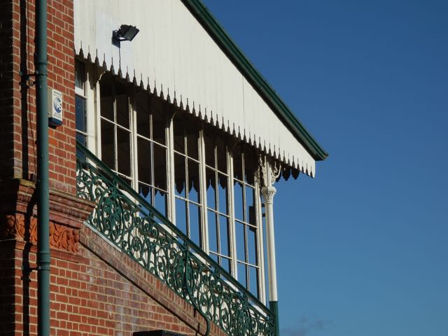
Most of us are familiar with the front, but few take in the
view of the rear elevation, with its red brick and tiled decoration.

However, a long-term plan for the pav seems a likely outcome of current discussions.  Though costly, the building which everyone loves, at least from the outside, is in dire need of investment.  It should probably be considered an Asset of Community Value to add status to plans for its revival.  An imaginative plan without compromising the view of the building across the park is surely possible; and there are equally imaginative funding schemes around to help make any reasonable proposal a reality.

Monday, 25 May 2015

Community Centre Future Plans


On Friday 15th May proposals were unveiled about plans to replace the current building used for the Fleetville Community Centre.  A large gathering of past and present user groups and their members heard for the first time that the Trust which runs the Centre is to make a serious upgrade to the facilities on its Royal Road site.

A presentation given to guests revealed that it had been 102 years since Charles Woollam donated the land which became 'The Rec' for the people of Fleetville; 73 years since the low-height temporary building on one side of the park arrived as a wartime emergency nursery; and 33 years since Fleetville Community Centre first opened its doors in a flurry of local excitement.


Fleetville Community Centre in 1992
So, three birthdays were being celebrated, and the Mayor of St Albans and District was present to cut the cake.

For over one hundred years children have been able to play to their hearts' content on Fleetville Recreation Ground, and today it is busier than ever, with the welcoming little Beech Tree Cafe acting as a honeypot for the recently upgraded playpark.

It also rang with the sounds of little children from 1942 when the nursery was perched on its concrete platform above the underground shelters, while their mothers worked in the munitions factories, especially at Ballito Hosiery Works, where Morrison's is today.

Mayor Geoff Harrison with some members of the Community Centre
Trust and Friends at the event.
Recently, the Centre's Trustees have decided that the popular building will need to be replaced by a structure offering a higher standard of accommodation, more space and a significantly lower energy footprint.  The Trustees are in discussion with St Albans City and District Council about their plans.  The existing centre is owned by the Council and let to the Trust on a lease which expires at the end of next year.

Guests at the celebration obtained their first glimpse into the future – a glimpse which they themselves will help to forge.  They were given the opportunity to offer and discuss their own ideas for a new building.  At present there is very little to see, except examples of other recently-completed centres, and of course, a picture of a daunting but exciting process to go through.

Accompanying the presentation was an exhibition, It All began In 1913,  which can be seen again at Larks in the Parks on June 28th.

A drop-in facility is open at the Centre on Tuesday and Thursday mornings until the end of June to find out more about the new building project and to talk over ideas which users and others may have for the proposed new building.


Saturday, 2 May 2015

A few old school ties

School photographs are often of two generic types.  One is the individual head-and-shoulders 'mug' shots, usually via a photographic company who gives you a sample and offers a pack of larger prints to your parents at a price.  The school usually retains a contact print to attach to a school record card.  At least that is the way it used to be, but records are often digital today.

The second is the class photo, or even, if Head Teachers are brave enough to organise it, a whole-school picture which usually has to be stored in a roll because it is too difficult to display without the living room wall giving an impression, by the time we are in our final year, of a panelled common room wall at a historic school premises.

Fortunately, there are opportunists who occasionally have a camera handy and are able to snap a few less formal shots: sports activities, special projects, performances and concerts, and school visits.

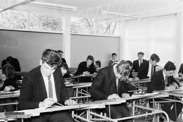
The photos which appear with this article were all taken when Marshalswick Boys' School (now named Sandringham School) was in its infancy – the early 1960s.  There are several in the collection.  On another occasion I will post a few of the teacher pics.  Meanwhile, here are classroom views and the occasional rehearsal.

You may recognise your younger self and your younger friends.  Today you may still live in St Albans, perhaps even in Marshalswick itself.  But you may have migrated as far as Hatfield, or one of our northern powerhouse cities, even abroad.

It would be great to hear from former pupils of these studious classrooms.


Sunday, 19 April 2015

A Healthy Hatfield Road?

In 1974 members of Woodville Women's Club, Fleetville, expressed serious concern about the changing nature of the businesses along Hatfield Road, worrying that "Fleetville is gradually becoming a dying area; that there will soon be no shopping centre left, as offices and banks replace shops."

Certainly, the mid-70s was a difficult time for many suburban areas, and it is true that, as business rates for city centre premises increased quickly, firms "on the edge" of financial success moved further out in an attempt to lower their overheads.  At the same time many family businesses were struggling to survive a lack of street parking, as well as the rise of larger shops in better locations accessible by car.

The mid 70s was also the final period grocery and fresh food shopping could put on a show without the intrusion of supermarkets.  But was Woodville Club right, with hindsight, to express such concern?

Both in 1960 and 1975, between Beaumont Avenue and The Crown Hotel (but not including Stanhope Road shops) there were 89 business premises which could be called shops; whether occupied as such is another matter.  Today five more premises exist which, previously, were  other kinds of premises.  Although Morrison's has been counted as one retail unit, it is functioning as a newspaper shop, cleaning shop, cafe and flower shop as well as a source of food.  The only premises not included in the survey were filling stations, of which there were up to five at the peak, though only one exists today, and factories and workshops.

It is not easy to assess what is or is not a shop.  Laundries are included because they are trading with physical products, and often ancillary products can also be purchased; betting shops are not included, as they are dealing purely in financial transactions.

In 1960 eighty-two premises could be classed as shops.  By 1975 this number had fallen to 57, and as Woodville Club members had observed, much of the difference was accounted for by banks, offices, betting shops and insurance companies.  Currently the number is 78.  Between 1975 and 2015 was another change not visible in the statistics given.  Many of the small independent grocery and greengrocery businesses disappeared as the supermarket era opened on what is now Morrison's site, but had begun with the Co-operative Society.  However, many new independents have arrived, some selling a wider range of goods for a wider cultural market.  Still related to food, the number of restaurants, cafes and take-away food shops has increased from four in 1975 to 14.  This includes three adjacent units near the Rats' Castle, the cafe in Morrison's, and the little Beech Tree Cafe at the Rec.  Fleetville Cafe is also included although we wait to discover its future.


Many changes in shopping habits were evident in the 1960s and 70s, as households' income improved, fridges and freezers were purchased, and cars enabled access to shopping experiences further away.  So 1975 certainly appeared to be a nadir for local shopping.  Today, Fleetville is probably thriving as much, if not more so, than in its between-wars heyday when the brand "a mile of shops" was applied to Hatfield Road.  And today, there are more shops opening for trading for longer days, and more days, than in 1975.

Hatfield Road, it seems, is as healthy a shopping district as ever, which just one disappointment – the disappearance of those corner shops which were useful in the side roads of Harlesden, Sutton and Castle.


Sunday, 12 April 2015

Roll on; where are we?

We are very used to contract companies arriving nearby to carry out road repairs; especially major works.  But there was a time when most of this work was undertaken by what was known as direct labour.  The council, city or county as appropriate, effectively ran their own company to undertake the contracts required by the authority.

A variety of specialised machines are in use, including those whose sole function appears to be to lay out miles of cones, sometimes doubling up as giant, vehicle mounted, matrix signs.  The driver and mate occupy the cab as the work proceeds, only returning to their duties at the end of the blockade.
City Council road roller working somewhere in the city.
Photo courtesy ROAD LOCOMOTIVE SOCIETY.

Life was simpler in the early twentieth century.  There were no cones, but generally there was a determination to complete the task as quickly as possible, and if a hole in the road was left overnight, a night watchman was left to supervise, with a hut and brazier.

Among the specialised vehicles then was a version of machine still important today.  The council acquired road rollers, as illustrated in the photos.  It appears that these machines were rarely photographed and it was a surprise to be sent a picture, probably taken between 1913 and the early twenties, located somewhere in St Albans.  The Road Locomotive Society would very much appreciate knowing the location of the roller when "snapped".

Modern photo of the same roller
visiting its old base in Grimston Road.
Photo courtesy SANDY ROSS.
From observation, the pavement had a blue brick surface, which was near-universal within the 1879 boundary, so, at least we can ignore the more modern suburbs.  The only other clue is that work was going on at a T or X junction.  Bearing in mind that a lot can change in nearly a century, much can also remain the same.

So, if eager blog readers think they can recognise the location, do please post a comment.  The Road Locomotive Society members will not be the only people whose minds will be set at rest.  Even if the location proves not to be in the East End of St Albans, we  know that the machine would have worked there, and from 1930 onwards was based at the old prison in Grimston Road, which is at the city end of the East End.  The former prison was the Council's Highways Depot.


Sunday, 5 April 2015

What does a trading centre need?

149 Hatfield Road with a gable bay. Courtesy BARCLAY'S.
It took a while to happen, but Barclay's was the first bank to open premises in the east end suburb of Fleetville.  Well, the Crown actually.  Alexandra House was constructed around 1912 on the corner of Hatfield Road and Clarence Road (not shown here).  Barclay's not only saw opportunities for hundreds of potential personal accounts nearby, but felt it could support the many businesses, including shops, along Hatfield Road.

Since then other banks followed, including Westminster (later National Westminster) and Lloyd's.  Jockeying for position, Barclay's vacated Alexandra House for a shop which had previously belonged to Mr Grimaldi and then St Albans Refrigeration.  From this position it stared the National Westminster in the face across the entrance to Sandfield Road.

Same shop converted for the bank. Courtesy BARCLAY'S
So where are these banks today?  In spite of increasing business activity the banks have retreated to their city centre hot-spots.  Although Barclay's and Lloyd's have strongholds at The Quadrant.

Recently, Barclay's opened another facility, online this time.  Not the usual website banking outlet, but an archive in which it has deposited a number of its own photos to remind us of the great days of banking.  In addition to a 1935 shot of Alexandra House, there appeared before-and-after pictures of the bank's move to 149 Hatfield Road (right), together with a peep inside at what, in the main branches at least, would be known as the banking hall.

Comparing the before-and-after shots reveals just how dramatic the changes to the building were, not only to the frontage at ground floor level, but it involved the complete removal of one of the full-height bays (today there are just two left in this block).

The banking hall at 149 Hatfield Road.  Courtesy BARCLAY'S
For those who recall the days before patrolling police officers had radios, you will be delighted to spot the pillar on the street corner which contained a telephone handset and a flashing beacon to alert attention.  Then of course there was an example of one of the city's first roads to have sodium street lighting installed in 1938, much hated at the time.  It has taken another three-quarters of a century for the softer (and more energy-efficient) LED to be recently installed.

Barclay's at The Quadrant had to wait to expand into a second unit; but just look at the curved counter in the banking hall.  Remember it anyone?


The brand-new banking hall at The Quadrant in the mid-1960s.
Courtesy BARCLAY'S.