Monday, 28 October 2024

Cape and Burleigh

 This is one of those posts which points out back of beyond streets which most of us have not explored, let alone heard of.  Between Sutton Road and Ashley Road is Castle Road, named after the field of the same name, which itself was named after the informal title of a turnpike toll house in the 1880s, the Rats' Castle.  Castle Road became a diversionary route when parallel Hatfield Road occasionally flooded near to Sutton Road.

Castle Road extends left to right across the top of the photo.  Cape Road is from top to bottom
on the left, and Burleigh Road is from top to bottom on the right.  The triangular open
space is in the lower part of the image and below that is the green strip of Alban Way.
COURTESY GOOGLE EARTH

Manufacturer Horace Slade was also a building developer who at the turn of the century acquired a nominal amount of back land between Castle Road and the former branch railway, now part of Alban Way. Two cul-de-sac roads were laid out c1900 and given the names Cape and Kimberley following British success in the second Boar War.  Kimberley was renamed Kimberley East in 1926 and renamed again to Burleigh in 1928.

Above name plate identified the former name of the road before 1926.
Below is the name plate for the first two homes complete in Cape Road.


Spasmodic development took place before World War One, with later fill-ins.  An awkward end block between the two roads against the embanked railway track was acquired by building firm H G Bennett and wood dealer William Halsey who also had a house adjacent to the Cape Road site.

Over in Kimberley Road (now Burleigh Road)  a small nursery holding existed until c1930, although it was probably out of use before then.  The St Albans Cooperative Society, searching for a bottling plant for its milk department, purchased the former nursery for its own building, with an entry onto Burleigh Road.  Although a driveway  might have been possible onto Ashley Road that road was not surfaced and developed until a short time later.  After closure of the Dairy its buildings remained empty for many years until the modern homes replaced them.
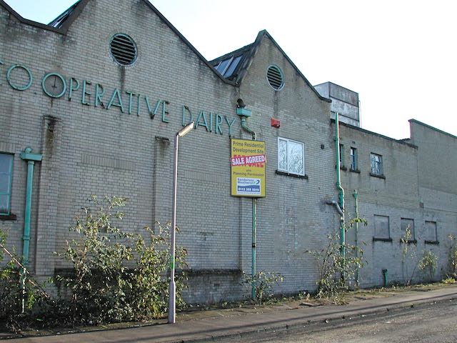
Above: on the site of the original nursery arrived the dairy owned by St Albans Co-operative.
Below: an array of modern home which replace the Burleigh Road dairy.


Bennett's site, and that of Halsey's, became a growing and successful site for supplying building materials for the trade and retail, their owners, including Pratt's changing hands over time; even employing staff from the Hatfield Road company of Lavers when that  timber yard closed.
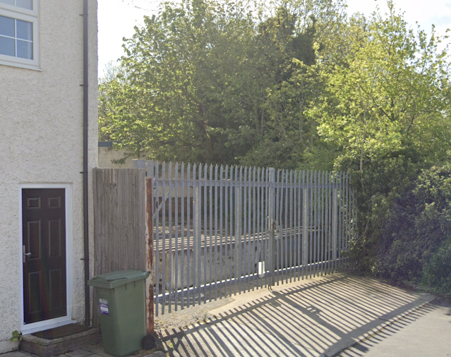
The old entrance gate at the lower end of Cape Road.  Through here trundled in and out the trucks
loaded with building materials. 

In 2023 the site was acquired by developer Viciniti which proposed, and received planning consent for 37 homes – a mix of flats and houses.  I guess that most of us assumed building had begun and continued at its own good pace, although activity appeared to pause as the company, including several other of its sites fell into administration.

This unfortunate process is not without its problems: continuity is important and when there is a break followed by a different team moving onto site issues can arise, although not inevitably so.  New costs are also introduced which would need to be absorbed.

Above: plan of the proposed new housing development at the lower end of Burleigh Road.
Below: a partly finished building within the dormant development.


Developer's image of how the earlier unfinished block is intended to look when complete.
COURTESY VICINITI

Nevertheless, according to recent advertising the part-complete development has been offered to the market, so perhaps it will not be too long before work resumes.  One fact we are informed about, as long as the new developer does not alter its arrangements, the names of two new roads between Cape and Burleigh roads will be known as Iceni  Close and Viciniti Court.


Wednesday, 16 October 2024

Kitchin in Harts

 Today's title attempts to include two seemingly mis-spelled words into the blog.  Recently I was fortunate to receive a historic folded map of Hartfordshire drawn by Thomas Kitchin.  I have discovered Mr Kitchin's name occasionally with an e instead of a final i; and the mapmaker insists that our county, though often spelled with an e, should "always" use the letter a.  Which I suppose is correct even today when we pronounce the name as in tart, rather than as bert!

I have to admit I had not heard previously of Thomas Kitchin, and I'm pleased I now have, even more so that he had a connection with St Albans.  Although he appears not to have been born here, he lived in the town (as it then was) during his later life, with a residence in Fishpool Street, and was honoured in death by being buried in St Albans Abbey (Cathedral). Note, in the church, not at the church.

The home of Thomas Kitchin in Fishpool Street, photographed a few years ago before more
recent scaffolding appeared.

In 2024 a blue plaque was fixed to the front of Kitchin's former home, which sent some of us
scurrying for more information about the eighteenth century cartographer!
COURTESY ST ALBANS CIVIC SOCIETY


I had clearly not paid sufficient attention to the Civic Society website either, which records the progress made on the current range of blue plaques.  A recent plaque affixed to a Fishpool Street house marks that belonging to Thomas Kitchin himself.

Thomas Kitchin produced a wealth of maps during the eighteenth century; and his Hartfordshire map seems to have been revised on occasions, the one I now have has a date of 1775 appended to the cover.  The original would have been monochrome, but my version had a hand-painted colour wash add to distinguish the various Hundreds into which the county was divided. 

Naturally, for the purposes of this blog I was keen to inspect the eastern districts of St Albans, which, at the scale produced included rather less marked detail than, for example, the Dury & Andrews map of the same period.  Which, in turn, features fewer detail than William Kip's county map of 1610 – it was probably a derivation of an earlier engraving.

To provide us with a comparison, Kip's map of the county dates from just 35 years after the opening of Shakespeare's Curtain Theatre in Shoreditch.

William Kip created a new engraving c1610 from an earlier cartographer, probably from the
mid seventeenth century.
COURTESY HERTFORDSHIRE ARCHIVES & LOCAL STUDIES


A partnership of Andrew Dury & John Andrews resulted in a 1766 county map produced on nine 
sheets.
COURTESY HERTFORDSHIRE RECORD SOCIETY

Thomas Kitchin produced a number of county maps, including Hartfordshire.
This version is dated 1775 and is likely to be sourced from previous engravings.
COURTESY OLD MAPS LIBRARY


The Kip and Kitchin maps are of similar scale, although their production is well over a century apart.  Kip dispensed with roads altogether, in favour of streams and rivers, and most importantly key properties where gentlemen of note resided, and specifically any warrens they may have owned.

Kitchin recognised the importance of roads which connected towns and the distances between them.  The road on this sample of his map is the one between St Albans and Hatfield; the circled number being the number of miles between them (6.0).  Other roads which connect with the Hatfield Road are also drawn.

Dury & Andrew have presented all key roads which are part of the local network, the topography and a simplified field layout.

Beaumonts, then a manorial seat on all maps is spelled – and perhaps pronounced – in three different ways: Beamondes, Bemonds, and Beamond.  Oaklands was too recent to appear on any map and was not sufficiently important to be added to the engraving as its original name, Three Houses; it had first been identified under this name in the fourteenth century, maybe even earlier.

Once again Kip is too limited in detail to mark what today we refer to as Marshals Wick. Both Kitchin and Dury use the letter c (Marchals Wick).

As we might expect the larger scale of Dury & Andrews provides the opportunity of marking a number of farms.  We know that Jersey Farm had only changed its name in recent times, but its former label was already in use in 1766; so it will take more investigation yet to discover the source of the name Evan in Evan's Farm.  Nearby, where we might have expected to find Marshalswick Farm – or rather Marchals Wick, we see instead the name Wheelers (or Wheeler's); so these two names extend back at least three centuries.

The present day location of Cunningham Hill had previously been known as Curry Comb Hill.

Finally, our newly-found Kitchin map incorporates information not included on the above extract.  Spaces around the map's edges reveal a range of abbreviations (which it labels Explanations): Vicarages, Rectories, Windmills, Watermills, Post stages, Parks (presumably grounds  attached to the private domains of gentlemen of note), Market Days, and Roads open and healthy. Parliamentary Boroughs have stars attached.  We are usefully reminded, for the benefit of map users of the eighteenth century, that the number of furlongs in each mile is eight.

So, the three historic maps sampled above were very different and provide us with a range of contexts for understanding the landscapes of our county in previous centuries.


Saturday, 12 October 2024

A Topper

 Thomas Smith, the owner of the printing firm of the same name which launched into the locality, opened his works (now Morrison's) and forever is associated with naming the district after the Fleet Street district from which the business derived.  Thus we know Fleetville.

Two blocks of nearby land had remained undeveloped at Thomas' death in 1904, and it was left for Smith's sons to manage.  One was land between Royal Road and Tess Road (now Woodstock Road South).  On the latter corner, where is still the Post Office, was – for a fleeting moment – a little cinema; but that is another story, told in detail on the accompanying website.

When Dr Frederick Smythe first arrived he occupied 209 Hatfield Road. In 1930
the property included ground floor rooms, one of which may have been a
waiting room and consulting room.

On the other corner was an impressive brick detached house constructed soon after 1930. In that year arrived "the local doctor".  He was Dr Frederick Smythe, in the terminology of the day physician and surgeon.  He took up residence in Bycullah Terrace, and presumably had his consulting room there, on the ground floor.  Today, the premises is EHS, between Simmons and the Convenience Shop.

The Hatfield Road elevation of Fleet House, although its address has always been in Royal 
Road.


The Royal Road elevation, originally the front, as indicated by the newer brickwork which
had been the porched front door when first built.  On the far left is the slimline detached
house constructed in the garden of Fleet House.


Dr Smythe lost little time in purchasing a plot of land from the Smith estate, the afore-mentioned location on the corner of Royal Road and Hatfield Road, and had the brick detached house constructed for his consulting room and domestic accommodation.  There was even space for a small garden and a pleasant green space behind the boundary wall. The front garden is today far more enclosed by foliage than the managed beds of the early post-war period. Whether Dr Smythe named his property or whether it was applied later I'm not certain, but it was certainly known as Fleet House; why not, for it was in Fleetville?

There came a time after World War Two, when circumstances changed.  From a single household it became two households with its division into a ground floor flat and one on the first floor accessed via an external stairway.  Further, on the garden in Royal Road was built a slim detached house with an equally slim driveway for a car.  Thus there were three households on the same original plot.


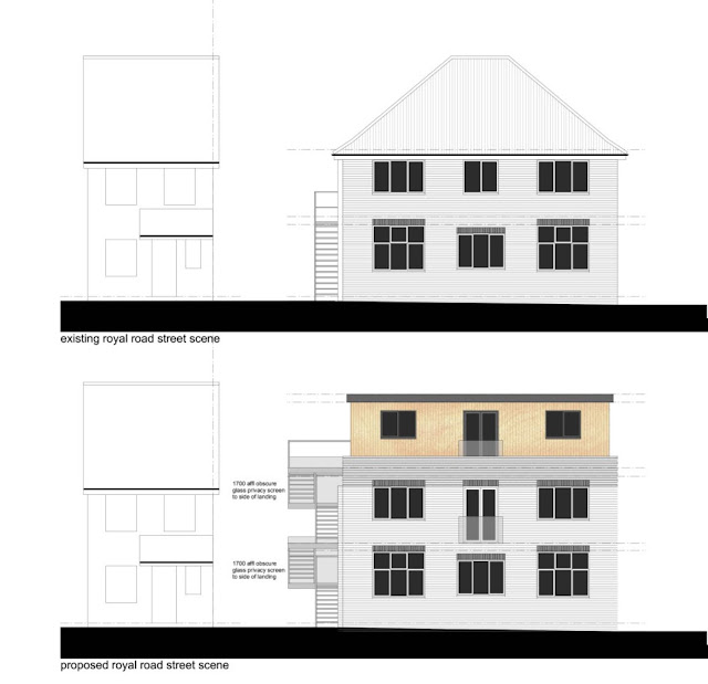
The elevations and plans appearing on St Albans District Council's planning web portal to indicate
what was was proposed in 2023.
COURTESY ST ALBANS DISTRICT COUNCIL

For those of us who have walked along Hatfield Road recently we have noticed a board heralding imminent works.  With some surprise the lovely house quickly lost its roof, not in a storm but by careful removal.

The arrival of two prefabricated sections which were lifted on the original decapitated building
to form a new upper floor and a third flat for the site.
COURTESY VIC FOSTER


The road has re-opened the traffic cleared and work continues to enable a fourth household to
occupy this corner plot in Fleetville.
COURTESY VIC FOSTER


And on a day in late September 2024 there arrived a crane and a lengthy low loader which reversed into Royal Road – and not without creating some congestion.  Aboard the vehicles were sections of a third floor to Fleet House, pre-built timber sections, lifted into position.  Thus Fleet House, in one day, changed from a two floor house with a pitched roof into a box of three floors of not much greater height.  Access to first and the new second floor flats are both external.

We wish the new inhabitants well, as they enjoy their view over the recreation ground – and Morrisons!