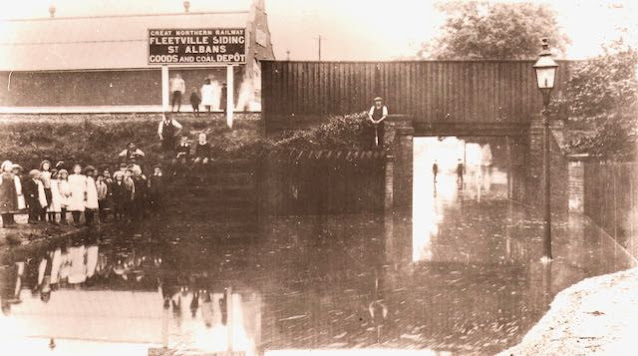
Last week we landed at a cul-de-sac which was once part of the branch railway sidings at Fleetville, and is now called Coach Mews. This week we move just a few metres to locate a railway bridge across Sutton Road which was shown in the previous blog.
Many residents living in or around Fleetville have little or no knowledge of the bridge; its loss was some fifty years ago, although the bridge deck was lost even earlier. But the story of this little railway bridge began some forty years before any building in Fleetville was planted on the landscape.
The line which Sutton Road takes today was a farm track right on the edge of Beaumonts Farm, and it was there because there had also been a stream here – water courses often marked the boundaries between properties or districts. The track beside it was used by carts and their horses working that part of the farm. The stream appears to have been a former stream even by the early-nineteenth century and it is probable the track followed the bed itself rather than being laid beside it.
When the railway arrived in the 1860s the embankment was created to ensure farm carts were still able to use the track; thus what is known as a simple occupation bridge was constructed. The little embankment beside Coach Mews was created to enable the trains to climb over the cart track, which of course is now Sutton Road.
The cart track was little wider than the carts themselves and so the bridge parapets were also not very wide – certainly not wide enough for two carts to pass. Across the top iron beams were laid to support the rails; only one pair as it was a single track railway. A simple wooden fence crossed the bridge to protect the rails, but this may not have been an original feature, added later when pedestrians passed underneath to the new factories and homes nearby from the early 1900s.
What must have been clear from the start is that loaded carts could not easily pass under the bridge, even if empty ones could. The response to this issue was to dig out more subsoil from the trackway under the bridge. But it was quickly realised that this brought the water table closer to the surface and in wet weather the cartway easily flooded.
To assist pedestrians a raised wooden walkway was constructed, first on the Fleetville Sidings side of Sutton Road. Later photographs show a similar timber walkway on the west side of the road, replacing the former structure. The purpose of both was to enable safe passage for pedestrians above the water level when the hollow under the bridge was flooded, which it frequently was. The second boardwalk must have been removed some time before the Second World War; it certainly wasn't there afterwards.
The deeper the floodwater the more extensive was its surface area and extent. Most of the known flood images were probably taken as they included children's activity, enjoying the novelty of an informal paddling pool. The sobriquet Sutton Lakes was made popular from these early years. One issue arising for the wet weather lake formations was the increase in numbers of pedestrians climbing the embankment on the east side and crossing the railway line at the top. While this was never a busy railway, such a venture can never be considered zero risk, and it is children who inevitably would, and did, attempt it, undoubtedly for the fun rather than for need.
 |
| Photograph looking towards Hatfield Road taken in 1967 shortly before the bridge was "decapitated" and all rail traffic had stopped. COURTESY ROGER D TAYLOR |
 |
| The bridge has disappeared. Improvement works to benefit Alban Way. |
Access under the bridge for vehicles was limited, both in width and height – headroom was 10 feet and the creation of a very narrow pavement of no more than two feet width ensured travel levels were low; bicycles and small cars only!
No time was lost after the 1960s final closure of the route; the bridge deck was unceremoniously removed, but it was sometime later that the parapets and embankment were demolished. Quite a day when the hollow was finally filled in and kerbed full width – a normal road, and the bridge was just a memory. However, nearby residents will attest Fleetville has not yet seen the end of flooding at this little corner of town.


