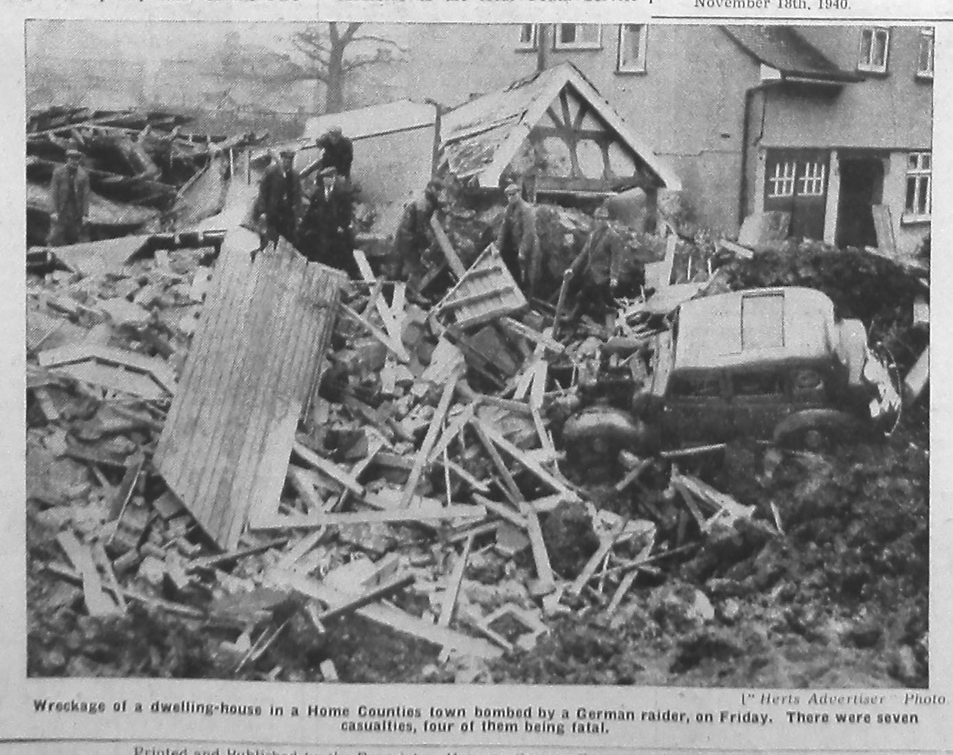
Sunday 11 December 2016

Washing taken in

One of the helpful services which arrived on Fleetville's scene in its early days was the laundry.  One was at a house at the junction of Hatfield Road and Ashley Road – Mrs Symons, under the name Handalone Laundry – and the other at a small house almost opposite the Rats' Castle public house.  Both opened their businesses of "taking in washing" within a year or so; Mrs Symons opening first c1909 in a house newly built.

Hatfield Road looking east from Sutton Road.  Mrs Walker's cottage
and the extension beyond for the County Laundry. c1922.
Courtesy ANDY LAWRENCE
However, Mrs Turner had moved into her new house right on the edge of the former Beaumonts Farm two years earlier, but she had not stayed to see out the decade.  William Moores and Arthur White kept a farrier's yard and coach repair shop behind the house – if you had looked along the drive to the left of the house at any time until the last week or so you would know nothing seemed to have changed in all that time.

In 1910 Mrs Rosa Walker moved into the little house with a bay window, and promptly opened her own washing business.  At that time there were few houses east of the Rats' Castle (which itself was not opened until 1927), and Fleetville, indeed St Albans, finished at Ashley Road; beyond was countryside.


The laundry has become The Emporium.
While Mrs Symons' laundry continued until around 1938, Mrs Walker's may have faltered soon after the start of the First World War.  Important caveat here though; given the large numbers of troops billeted in the city for most of the war, Mrs Walker may have had a successful period until the soldiers went.  What the directories are clear about is that the end of the war didn't mark a closure but a sale.  By 1922 the building had been taken over by a Hatfield firm, the County Laundry, whose owners lost no time in building a dedicated laundry building.  At the back was the boiler room, and washing and drying facilities.  The ironing department was at the front.

It wasn't an expensive building: basic walls and iron roof trusses, with large wooden window doors alongside the road.  Apart from the enlargement of the window spaces at the front and adaptation for retail use, that is how the building remained throughout its life.

In 1953 the fascia panel which ran the full length of the building, was decorated with coloured lights to celebrate the Queen's coronation and in the early sixties the company changed its name to Hatfield Laundry.  The traditional laundry style was modernised to become a dry cleaning operation.  As this required less space the eastern section was let to Charles Gentle.  His builders' merchant trade specialised, first in plumbing supplies and then in decorative tiles, being renamed Tile Depot.

Demolition behind the frontage.
Courtesy VIC FOSTER
Activity then returned to being rather Victorian in name and style – or you might think rather modern in having concessionary counters each run by a sole trader.  The Emporium, attracted shoppers from Hatfield Road, and it often took some time for them to appreciate there were further buildings at the rear, more recently named Ballito"s, picking up the name from a former, more famous, company nearby.  And not forgetting that, for a short time, a digital design business found a home in the old cottage.

The owners have attempted on several occasions to redevelop the site, and now demolition is finally taking place.  The laundry site is one which many might have considered ripe for development forty years ago.  Most of us will find ourselves surprised once the site is cleared; surprised to discover how extensive the premises were.

Friday 2 December 2016

Colliding stories

We all enjoy listening to stories, and often to telling them too; it's one of the many ways we relate to each other in our families or our communities or our country.  It is also deeply connected with the celebration or commemoration of anniversaries – including the re-telling of stories.

Tasked with the need to fill a twenty-minute slot in an AGM at Fleetville Diaries, the local history group, I considered an anniversary event as the subject.  It was 76 years ago in November when the heart was torn out of the city of Coventry with an eleven-hour bombing marathon using 500 heavy aircraft.  I had intended it to be referenced to national stories, though aware that at the same time someone else was bound to be relating or remembering the same story as a local event somewhere in Coventry itself.

At the same time I had been browsing lists of surnames in family history websites, when I was handed a scan from pages of the Second World War Roll of Honour for the Civilian War Dead.  These pages referred to loss of life sustained in St Albans, both the city and rural district.  One name from this Roll of Honour also appeared in my browsing list of surnames.  Strowbridge.  To the family historian this surname, though not central to her researches, was nevertheless part of her family, but she had not thus far been able to bring her knowledge forward from the late19th century.  I therefore decided to establish whether her Strowbridge was the same family as the one of which four members  were killed in a dreadful event in St Albans.

It did not take long to confirm the connection, to build some knowledge of the grandparents, parents, children, nephews and nieces, and where and why the had moved from place to place.  In 1939 large numbers of people were on the move – young people being called into the services, far-flung members of families returning to be with each other, being ordered to specific places for work in the national interest.

The Strowbridge family arrived in this way to St Albans and moved into a rented house in Beaumont Avenue.  As other members arrived the now-extended family moved along the road to a slightly larger dwelling, where late in the evening in the middle of November, their shelter was destroyed by a stray bomb carelessly dropped on that endless commute of planes circuiting between their French bases and the city of Coventry.

Courtesy THE HERTS ADVERTISER


So, there we had it.  Two stories, seemingly quite separate, but clashing violently here in St Albans.  Taken together it was a pin-dropping account, and that might have been the end of it.  Except that one member of the group announced that she had been there that night in Coventry; a toddler being passed out of a coal cellar of a bungalow after her family's night of hell.  My twin story suddenly found a personal embellishment; someone else's story brought together with mine so movingly.

Not heard by most of the members present was a further recollection in that period of chat at the end of the formal meeting.  It came from a member who remembers chatting to a builder undertaking some work at a nearby house in his road.  In some of the inevitable downtime during the work, the builder related that he had also worked on a re-built house in Beaumont Avenue.  He had discovered evidence of a large hole in the front garden, in which there had still been the evidence of domestic accessories, particularly pots and pans, cutlery and other items; left as it have been thrown around and damaged when the bomb had been dropped.

By the end of the evening two members of a local history group had been afforded the opportunity to  re-tell their own stories, because I needed to fill a twenty-minute slot, deciding to relate an awful event which began by not having anything to do with St Albans.
I am not confident, either, that this blog will be the end of the matter.  Someone out there may have a story which links with the above.

That is what makes story-telling so fascinating; we never know where it will lead.

Sunday 13 November 2016

Historic streaming

Ask anyone for the name of a river in St Albans and the answer will naturally be the Ver, with a name sourced from the former Roman settlement which has made the city well-known.

A reference might also be made to the Colne, into which the Ver flows, especially as this snakes  through Colney Heath and London Colney.  Both have been favourites for generations of families and their times of recreation.

Which raises the intriguing question about whether all rivers and streams are named.  Perhaps the notion of giving a watercourse a name only became the norm as maps became more common, from the eighteenth century onwards.  Though I have to admit, this might not be strictly true.

Let's explore more watercourses in the East End, all of them which flow, or flowed, from north to south.  A short stream or brook called the Ellen crosses under St Albans Road West en-route to the Colne.  Today it carries little water and is at its most natural as is passes through Ellenbrook Fields, although through Ellenbrook itself it has been culverted.

Just west of Smallford is a stream, also north-to-south, which has two names.  North of Hatfield Road it is known as Boggy Mead Spring, whereas south of there it has the delightful name of Butterwick Brook and was responsible for providing a name for the original Smallford settlement, since there was no bridge over the stream.  This also finds the Colne.

There have been sufficient hints and surveys in the past pointing to a stream which rose at or near The Wick and flowed southwards parallel to Woodstock Road into what is now Sutton Road and then turning near Campfield Road, across Camp Road and London Road before meeting the Ver.  No-one has seen it in recorded history, of course, but there is still sufficient evidence when we experience very wet periods.  Unlike those just described no name has been ascribed to it that has been documented.  And a similar absence of name for a further stream which may have flowed, at least seasonally (a bourne?), also from The Wick, roughly following Clarence Road, dropping down to the previously described stream on its way to the Ver.  For this one we have to rely solely on the topography – much altered of course with urban development.

There is one other stream, and this one suffers from not showing us a direction of flow, still less a name.  But there is a suggestion.  The 1840 tithe map identified two adjacent fields, where today are the Willow estate and Ashley Road industry, and named Hither Bridge Field and Further Bridge Field.  The fields would already have had established names, and 1840 was before the nearby railway.  One of the fields lay on the highest land in the immediate district, and we can still discover Drakes Drive, Cambridge Road and Ashley Road descending from the "heath".  In fact from the Hatfield Road/Beechwood Avenue junction, drive the car towards Oaklands and the first thing you notice is that you are climbing a gradient.

So, if a stream rose hereabouts where might it have flowed after the bridge which we assume was in one of the two fields?  One possibility is down the Cambridge Road gradient to join the stream flowing near Campfield Road; another is along the line now Ashley Road and Hatfield Road towards the same stream as it crossed into Sutton Road.

There was a time, therefore, when the East End was awash with streams which disappeared as the water table dropped.  As to when that might have been, someone may, as I write, already be undertaking the research, which incidentally, is unlikely to reveal stream names!

Sunday 6 November 2016

Well done and not well done

Two events have come to light recently which link the former branch railway line between St Albans and Hatfield.  For those who are uncertain the route is now Alban Way, with stations included at London Road, Hill End and Smallford.

Smallford Station in 1947  Courtesy R D Taylor
Scene from film shot at the station in
1933.   Courtesy Smallford.org
The Smallford Heritage Group has recently acquired a certificate, reminiscent of those children would receive for being the best/most alert/highest scorer etc child in the school, and signed by the head teacher.

This certificate, available on Ebay, was awarded in 1947 to Smallford Station by the London and North Eastern Railway of which the branch was a part.  In the competition for best kept stations, Smallford won a first class prize.  There is no telling how many other stations took part, or won various grades of award.  Nor are we likely to know whether it was clean platforms, sparkling windows and a tidy coal yard which were considered for box ticking.  Maybe there were floral displays along the only platform.  It would be nice to think there were no weeds along the track either.  And if Smallford won a prize in 1947, did it also win prizes in other years?  Was it a question of "Smallford won, AGAIN!"

Best Kept Station in 1947.  Courtesy Smallford.org
Whatever did or did not happen – and assuming that the certificate did arrive at the station, maybe for a small presentation – the certificate had been retained somewhere for the past 69 years, possibly changing hands on several occasions, only to surface for auction in 2016.  It is now in the ownership of the Smallford Group.

At some future date, when the station is once more accessible and serves a useful function, perhaps the certificate will be framed and mounted on a wall of the booking office – a little late, perhaps, but nevertheless available for all to feel proud of.

A search of the Herts Advertiser for 1947 (and the start of 1948) revealed no report of the award, let alone a photograph.  But an event further along the track did just make it into print that year.  In the section – of an 8-page edition due to a post-war newsprint shortage – headed St Albans News in Brief, was the following on October 17th:

Sutton Road bridge in 1954.  It was this side which had
been demolished in the strike.
“Sutton Road was closed to traffic yesterday following the partial collapse of the LNER bridge over the road on Wednesday night.  The structure of the bridge was damaged when an army lorry struck a girder on the Campfield Road side and tore it away, causing the sleepers between the permanent way and the side of the bridge to fall into the road.  The railway line over the bridge was not damaged and traffic between the Abbey LNER Station and Hatfield was not affected.  A similar accident occurred at the same spot several years ago.”

For those who recall the Sutton Road railway bridge – where Alban Way crosses the road near the pedestrian crossing –  it was low, in fact very low.  Its headroom was ten feet, and that was after the road had been dug downwards.

The incident was at night and was caused by the driver of an army lorry.  In the years following WW2, military vehicles were common on our roads at all times of day and night, and especially on Sundays.  Bridge strikes were possibly quite frequent, then as now, but the combination of a military driver not familiar with his route and trying to use the only road linking Camp and Fleetville must have made this bridge vulnerable.  We are told that the timetable operated the following day.  Today, in spite of emergency overnight works it is probable that safety consideration would have dictated closure for at least a day.  But in 1947 it was a question of Keep Calm and Carry On.


Sunday 23 October 2016

A Cell Re-occupied

Some of you may have been wondering about the pause between the previous post and this one; it has, I believe, been the first month since 2012 when there has been a only single post within the  month.  Commitments have been heavy recently and blog posts have taken a back seat.

If you have lived in St Albans for more than twenty years you will be very familiar with the names of two, now former. institutions: Hill End and Cell Barnes.  Although they were not copies of each other, both cared for patients with a wide range of mental conditions.

Former Cell Barnes site being redeveloped.
The earlier – and certainly the larger – was Hill End and the former site is now occupied by a housing development.  The open space which surrounded the hospital is now in the care of Highfield Park Trust and is managed as an urban heritage park fully open to the public.  Hill End was not the only hospital to be closed 20 years ago, for Cell Barnes, which sat next door, also began closing its doors in 1996 (completed in 1998) for the last time.  Its many buildings have also been replaced by a new housing development, and like Hill End, the Metropolitan Green Belt regulations limited new building to  the footprint of the hospital buildings, so retaining the parkland.  All parkland except what was needed for a new link road, that is. Part of Highfield Park Drive now sweeps through the old playing field before linking with Highfield Lane.

While an example of a Hill End ward block and a lodge house from Cell Barnes remain, most other evidence has been obliterated, and it is probably not surprising that recent incomers have only the scantiest of information about former hospital settlements – or even earlier communities – below where the new homes have been built.

Last November Highfield Park Trust held a history event at the Trestle Arts Base, Russet Drive, where photographs, oral recollections and maps of Hill End could be viewed.  The evening included a lecture on  the history of mental care and the story of Hill End, under the title Hill End: What Lies Beneath.

A similar evening called Cell Barnes: What Lies Beneath, will be presented on Friday 4th November at 7.30pm, also at the Trestle Arts Base.  The story of Cell Barnes is remarkable in its own right, but equally heart-warming are the stories of staff who, though six decades cared for the residents, the lives of whom had been improved and enriched because of their care.

There are a few tickets left for this event, but you will be severely disappointed if you leave it until the last minute, because the seating available is limited.  The booking details are below.


Monday 26 September 2016

Roads Which are Part of Us

September may be the tail end of the outdoor activities season, but it surely is the best time to review what you have achieved during the Spring and Summer months.  As with five summers before 2016, the local history group, Fleetville Diaries, has arranged a number of guided walks around many of the roads in the Fleetville district.  Also part of the programme have been story walks meandering around Hatfield Road Cemetery.

Walks attract a fair number of guests, but fortunately not too many, given the limited amount of standing space at key stops such as junctions and narrow footpaths.  The maximum the organisers can accept for street walks is 25.  One guest's dog has also joined us on several occasions and appears to have taken a keen interest in his surroundings, if not to the speaker.

Wellington Road in c1954
The most recent addition to the programme was walked for the first time this week as an impressive number turned out to discover more about the Camp estate, particularly Cambridge Road.  This is not simply an opportunity to peer into people's front gardens and how they cope with cars and bins.  It is a trace through time, from when the streets were fields with hedges and streams, locked into the annual cycle of producing food for the table.

So is revealed the origins of at least some of the street names (we are still considering Wellington and Beresford roads), the many styles of house design helping us to locate where early gaps were later filled with newer homes.  Being a residential road well back from Hatfield Road's shopping mile, we can marvel at the number of shops which opened here in the first half of the last century; most no longer open for business

Guests are usually given location maps and laminated photographs to compare an earlier scene with the present day.  Such afternoons or evenings are a pleasantly social experiences, where talks become meaningful discussions.  Everyone has something to offer, and everyone goes home with a newly recalled memory or fresh information.
A story walk in the "Laid to Rest" series,
Hatfield Road Cemetery

As for the story walks, the organisers are frequently surprised by the number of guests for which this would be their first venture beyond the splendid main gates.  Among the thousands of burials in such green and peaceful few acres, stories about a small number have been researched and presented.  Of course, most people lead private lives and their stories are unknown to others.  But if we are to include those which Fleetville Diaries members will be working on during the coming winter, there are nearly fifty stories, told a dozen at a time.

Local history comes in many forms and a tramp around the streets is no bad way to discover more about our patch.  After all, these roads, and the people who live or work in them, are part of us, and we are part of that same community.


Monday 19 September 2016

A story with gaps

Recently I was reminded of a story I had been attempting to follow up for a number of years.  It concerned a school known as St John's Preparatory.  I have notes on over thirty private schools operating in the city during the late 19th century through to the 1950s, though not all at the same time.  But those about St John's are extremely brief.

St John's was one of a very few on the eastern side, at least east of the railway.  And it may have begun elsewhere before re-locating to St Albans.

Let's start from the year, 1899, when the first part of Beaumonts Farm was sold off for development.  Mr H Adey, of the brewing family, had acquired the brewing interests of Mr Thomas Kinder, and when the late Kinder's trustees sold some of the farm land Mr Adey was first to move in, having a large house built at the north end of Beaumont Avenue.  The name was Avenue House, but by the time the Misses Blackwood moved in its name had changed to St John's.

Beaumont Avenue, northwards to Hall Heath.
Avenue House shown as the only house in 1915 between
Salisbury Avenue and Sandpit Lane.
COURTESY HALS
Sisters Emma Mann Blackwood and Elizabeth Stewart Blackwood were born in Edinburgh and appeared to live much of their lives in Lothian.  Unmarried, both moved to St Albans and set up (or continued) a school in the Beaumont Avenue house which they purchased.  The sisters were both approaching seventy when they purchased the house.

Elizabeth died in 1932, aged 86, and Emma in 1933, aged 83.  One-time councillor and mayor William Bird then became the owner. In 1934 a new house built in Jennings Road, later becoming number 75, was named St John's and then St John's Preparatory School.  Living there was Mr R Pritchard.  Why, we may ask, might the school have pitched up in a new home?  It is possible that Mr Pritchard was assisting with the administration or specialist teaching under the Misses Blackwood in Beaumont Avenue.

When the school finally closed is so far unknown,  but fortunately I have been contacted by one former pupil from its time in Jennings Road.  He writes: "Thank you for providing some very interesting information  regarding this little-remembered school. I thought that all recollections of it were long lost in the mists of time.  I certainly remember attending this school in the early forties, at the end part of the war. We had mauve blazers , mauve  and silver horizontal striped ties.  Unfortunately it is here my memory fails me.  I didn't seem to be there for long, moving on to Fleetville School in 1944."

We therefore know that the school was in existence up to 1944; we know what the school uniform was like; and we know who ran the school, and where.  There may, though, be some personal recollections, a book or account – even a photograph – somewhere, if only it could be found! Until then there are, as can be observed, many gaps in the story.

In particular, I have never seen a picture of Avenue House, St John's.  It is, of course too late now, for St John's and its neighbouring property, The Grange, was demolished in the 1960s, being developed as St John's Court.

If you have a photograph of the old house, or know someone who has, you know what to do!


Sunday 11 September 2016

The democracy of desire

Every city, town and village has its own footprint shape, created as a result of  encroachment onto the undeveloped land around it.  You'll know what I mean as new housing on the edge avoids a river, old quarries, an outlier hill or protected green belt land. The boundary is irregular,  but the shape of the settlement is unmistakable to those who live there.

There is another unique footprint: the pattern of roads which enable us to get around (or pass through) our home town.  These veins, as a complete network, form unique patterns.  For the most part we don't need to know the names of those roads; the pattern they form is sufficient to identify where we are, or to pick out our town from any other.

There are road patterns, often associated with new towns or development towns, which have been largely designed into their place; superimposed on the landscape.  In many places, however, the road patterns, especially close to the town centre, appear disorganised, and it often seems impossible to tidy the pattern without the democratic opinion of residents getting in the way.  The great fire of London in 1666 did produce a grand opportunity to do just that – to start again.  Several plans were submitted in the years following the fire, all of which came to nothing, largely because there was no equivalent of compulsory purchase and land owners had no intention of giving up their precious plots for no compensation, just for a better road.  So today's City roads are not so very different from those before the fire, 350 years ago.

Footpath crosses a field near Smallford.
Former field footpath retained near Kingshill,
Marshalswick.


Now, let's move from the town streets to an ornamental park, or woodland, or even expansive open grassland.  The precursors to the town's muddled streets are here too.  Finger signs point us to footpaths, byways, bridleways and tracks, most of which have been worn through time to link settlements or individual dwellings.  While a proportion of them follow field hedges or lines otherwise fenced off, many ignore these boundaries, and some of the easier topography too.  Narrow routes have been democratically worn into the landscape over centuries and have now been accepted as a permanent part of the Ordnance Survey map.  Even where towns have spread and enveloped the muddied lines, they have been protected in the new developments as alleys (in some parts of the country known as ginnels, snickets or twittens).  They can't be obliterated or altered except through a very public legal process.

Aerial map reveals a network of paths across the former Butterwick Farm,
including a circular pathway around the willows and pond.

The most democratic of all these desire lines are worn by pairs of feet whose owners decide they will take the route they perceive to be the easiest, rather than the path that is intended they should use.  A community football pitch may, over time, also reveal where walkers between matches have crossed the field diagonally to reach a facility, or another route, on the other side.  Open parks with designed elements – mown grassed areas intersected with grids of prepared paths – will always show public use very differently as grass is worn along diagonals.  Angled paths nicely surfaced with red or green macadam are routinely ignored as grass, or even flower-bed corners, are worn with irregular use.  A short path of trodden soil or flattened grass reveals where casual users really wanted their path.

These tramplings are the most democratically created of all routes, where, as long as people are not trespassing or causing criminal damage, they decide their preferred route.  The decision made by that first pair of feet, is added to over time as yet another desire line across the landscape is forged.  Some will be short lived, but others may be reinforced over time, their status enhanced.  One day they may become a meandering city street and future generations may wonder why the road was not created straight!


Friday 19 August 2016

Being part of the story

Read almost any book which tells the history of a place and you are being told the story of people of some significance.  There is the possibility it might include detail of an individual whose record only appears because of a single event.

That's the problem; a history is not unbiased, it is not fair (as in, "you've only heard his side of the story" – and it usually is 'his', not her).  And it most certainly is not complete.

To try and fully understand the complexity of a recorded history of a person, a place, an event or a time period, we will begin with an individual: you, or me.  We have many opportunities each day to make our mark.  We email or text others, we take photographs, we complete forms (some for ordering products and others for banks and to record official events, such as births).  Our belonging to groups may include records of membership, decisions made or newsletters of our contributions. Who knows how many records are made of our employment, our health, our travel, our pensions.  We may write a letter, and if it is to a newspaper or journal, that and our name may be published and may form part of a dialogue.

Our daily lives are recorded in so many ways, most of them with at least some of our personal details.  Whether it all gets left around to be picked up by historians in five hundred years time will depend on how effective our descendant communities are in sifting and keeping; passing on our records or stories for future generations.  Who knows how permanent our digital records will turn out to be.  And if our photos are so personal to us why are we so casual about storing them, unsorted and unlabelled on our phones?


If we have impressed so many marks on history, just from our everyday lives, what about Thomas Blackmore and Elizabeth Fetty?  For the sake of this article I have to invent their names because they were just two of a small group of people who lived between St Albans and Hatfield in the early 1500s.  There is no record of their lives at all, not even their names.  It might be reasonably argued that therefore they did not exist at all.  But homes do not get built without a need for shelter.  Land is not tilled without a need for  food.  The continuity of a settlement is not sustained without children to form the next generation.

Thomas and Elizabeth, and others like them, were used to moving from one place to another, but we do not know whether they knew each other, married and had children, or whether they lived their lives as strangers.  They represent the wide base of a pyramid of  sixteenth century existence in every part of the country and in those parts of our east end of St Albans at that time occupied.

The point is, Elizabeth and Thomas survived and lived out their lives while others made the history we read about.  They were, of course, part of that history, but it was not recorded, even in the most rudimentary ways.  If only the voice recorder was available to Thomas, just as it is to us, so that he could speak his thoughts at the end of each day, or when some unusual event occurs.  Wouldn't that give us a more complete view of the period in which he lived?  Elizabeth's life was transitory, each day's existence wiped clean by the next.  Without an ability to read and write, or the opportunity to buy a medium on which to record thoughts as words, and a secure place to keep them safe, Elizabeth's life was not even worth to others the equivalent of an inscription on a park bench.

So, who gets to tell the paragraphs, pages and chapters of our collective history?  Power, influence and education have counted for most of the contributions, and our knowledge of the history of these islands have been dependent on the parts of the story they chose to tell us.  Those parts played by all the Elizabeths and Thomases down the ages are largely absent.  If we were aware of their evidences, surely that would provide us with a much more rounded account.  As it is, a democratic process it most definitely is not.


Thursday 11 August 2016

Do we need a bank in 2016?

Although no official statement has been announced by the company, a number of Marshalswick residents think they know that one of The Quadrant's two banks, Lloyds, is to close.  Whether they have made an assumption, base on the bank's latest national intention to close two hundred branches, on top of the branches in the current closure programme, may simply be speculation.  Lloyds' website only lists the tranche of branches being closed under the existing programme.  It states that after that programme "90% of its customers will still be within 5 miles of their local branch".  It is, though, a moot point whether a branch which is five miles distant can be considered local.

Barclays and Lloyds occupy opposite ends of a side block at
The Quadrant.
Even if every customer used online banking and cash machines (ATMs) there would still be a need for banks.  Cash which businesses need to deposit, or any of us, come to that; cash which we need to withdraw for our own use (and for which uniform £10 or £20 notes are not satisfactory; the advice and help branch staff are able to give, face to face, more satisfactorily than via telephone calls to service centres; ditto after online problems have grunged up our systems or been interfered with by malicious strangers.  If banks wish to add to their customer base, they need to invest in their customers.  Remember when banks universally opened weekdays only from 9.30 to 3.30?  Then they tried Saturday mornings with limited services. Then they closed again, leaving an ATM in charge. Now many have 9 to 5 opening and extended Saturday business for a full range of services.  Is this the time, then, to shut customers out and force them to travel out of their local area?

Barclays opened a branch at The Crown before World
War One.
Until World War One all of the banks in St Albans were in the centre of the city.  But then you could probably draw a circle a mile around the Town Hall and enclose almost everywhere, except for Fleetville and Camp.  Barclays was the first to open in the east, with a branch at Alexandra House, on the corner of Hatfield Road and Clarence Road, and there it remained until around 1968 when it moved to the corner of Sandfield Road.  The Midland arrived in 1922 (now part of Tesco Metro).  NatWest opened nearby in c1970, where the Grove charity shop is now, and moved to the other Sandfield Road corner five years later.  Lloyds pitched up at the Harlesden Road junction, now the home of City Glass.


Barclays moved more to the centre of its Fleetville
customer base in the 1960s.
Although NatWest and Lloyds seem to have arrived late on the scene, all of them recognised the huge mix of business potential in Fleetville – which would include Camp, given that no Bank existed along that road.  But today there are no banks in Fleetville, although there are broadly the same number of businesses and even more families.

Marshalswick has been served by two banks ever since The Quadrant opened, and since 1960 the eastern districts have continued to grow outwards.  It is not as if modern (i.e. online) banking has reduced the waiting time if we require counter service or need to speak with an adviser – meaning a member of staff who could make decisions, a role which used to be known as the Branch Manager.

Dare it be asked, that could the decline in banking availability be arrested by requiring us to pay for our accounts?  Should we have a right to complain if our account is serviced for free?  Maybe there is no room in the market today for two banks at The Quadrant.  Just as long as the one which remains doesn't "up-sticks" and disappear into a vortex as well.  And in order to spread a little banking happiness would it be too much to ask for the bank which leaves The Quadrant (if, indeed, one does) could not return to its old haunt in Fleetville?

Saturday 30 July 2016

1966 And All That

If there are two historical dates which it is thought everyone would consider significant, maybe we might choose – and both appropriate for this year – 1066 (William of Normandy/Battle of Hastings) and 1966 England uniquely win the World Cup.   They were 950 and 50 years ago respectively, and in the case of the World Cup it was 50 years ago this weekend.

In case you are wondering what the BoH and World Cup have to do with St Albans, well, the first doesn't specifically of course, but there was another event fifty years ago which connects with the World Cup and was specifically do do with St Albans and with a specific city in Germany.  That country is key, because of the team England was playing in that rather special game of football.

To start at the beginning – or maybe it should be the end; a group of people living in St Albans at the end of the Second World War heard from friends returning from the industrial city of Duisburg on the River Ruhr, Germany, about the dreadful conditions a large proportion of families were enduring.  They were holed up in basements, or the remains of bombed out buildings, with meagre supplies of firewood, food and clothing, and many suffering seriously deteriorating health.  Volunteers in St Albans collected clothing, food and simple medical supplies, and several lorry loads were taken across land to Duisburg, gifts which would be most welcome in winter. The exercise was repeated for two more years at least.

St Albans meets Duisburg and its mayor at Duisburg, Germany July 1966.
In the summer of 1948 the first group of Duisburg children arrived in St Albans by train for an extended holiday, paid for by the people of St Albans.  It became an annual event and later young people from St Albans stayed with Duisburg families, but this only became possible when living conditions there were much improved.  For our young people it was an exercise in healing wounds, even if our knowledge of German was poor.  Visits included to Cologne Cathedral, the Krupp steel works, the industrial energy of the Ruhr port, and a visit to the reality of the Ruhr dams.

The organisers were not to know who would be playing in the World Cup in the summer of 1966, and the visit of St Albans young people to Duisburg was planned ahead as usual.  We were already staying with our hosts when the teams playing in the final became known.  No visits were planned on Final day and we spent the day and evening with our host families.  For some the atmosphere was a little tense.  In my host's house there was a gathering of a number of my host's relatives and friends, and the atmosphere was relaxed.  Food and drink were prepared and I had the distinct feeling the spread was for an expected victory.

In a large and crowded sitting room everyone sat where they could; I sat on the carpeted floor, leaning against the arm of a settee.  There was much animated excitement throughout the match, and part way through the second half, realising I was the only Brit in the place, I did the unpatriotic thing and in my head I hoped Germany would win (I thought that might be the safer option).  But that goal at the match's conclusion which secured a win for England against Germany, taught me something wonderful.  Instead of a ribbing, even in jest,  every one of the fifteen or so family members in the room shook my hand and said, either in German or English "Well done".

I know that not every one of our party had the same positive experience in the homes in which they were staying, but it was a very uplifting experience for me.  A St Albans east end 22-year old had an experience that day which was more that just a result in a rather important football match.

Wednesday 27 July 2016

A Tramp's Life

Last alive in 1946, not many days or weeks pass without, in some context or other, without mention of the name Tramp Dick.

News of his death was featured in the Herts Advertiser in the issue of 15th March 1946, with the sub-title, "Death of a St Albans Recluse".  Most people who have lived most of their lives on the eastern side of St Albans, and who were born before WW2, will have a story to tell about this vagrant.  But if you were born in the 1940s or 50s you are more likely to have known someone quite different – with a trench coat, beard, swept-back hair and big army boots.  So, wasn't that Tramp Dick?  Well, no, but many children at the time, including me, called him Tramp Dick anyway, having picked up the name from our parents.  And he occupied the same corrugated iron hut in Jersey Lane, used by his namesake.

Another confusion: Tramp Dick – the real one – wasn't thought to be Richard at all, but Thomas, or Tom.  Tom Whiting.  But he had a brother called Richard.  Richard Whiting was the manager of the Gaumont Cinema, formerly in Stanhope Road.

Tom Whiting, aka Tramp Dick, sitting on a wall in Fleetville.  Are
there any other photos of him?
We make judgements about people all the time; it was just the same with Tramp Dick.  It comes as a surprise to many who knew something about him, to learn that he was intelligent, and although he liked to keep himself to himself, he could contribute confidently to conversations.  As to why he chose the open air life of a vagrant there is no firm evidence.  The legend has it his life collapsed after the breakup of a relationship with a young lady many years previously, but as with most legends the evidence is in short supply.

He was also said to have received an allowance, but who from, no-one is quite sure. But he was able to pay for his everyday necessities.  Since 1939 he had his own ID card and ration book, kept for him at a shop in Fleetville.  His income, other than any allowance, came from casual work on farms or from selling flowers or berries – which also earned him the sobriquet Blackberry Jack, even though his name wasn't Jack either.  Of course, it is possible that name  really belonged to someone else.

One fact is certain, according to those who knew him: he did not beg.  If he was given an item, a coin or some food, Tom would ensure he repaid the favour.  A very moral tramp.

Tom was found at home (Jersey Lane) by a resident of Long Acres.  He was thought to be 68 year old.  After a simple funeral, he was buried at Hatfield Road cemetery.

Wednesday 13 July 2016

We'll make a list

710 windmills, a skate park, 49 wrecks (of the ship variety), 9 tower blocks and 9,507 tombs.  These are among 398,000 other items on a list which accumulated through the whole of the 20th century.  Included also are two roller-coaster rides, thousands of churches, tens of thousands of houses, a collection of designed landscapes and monuments, and the occasional battlefield.


This, of course, is the National Heritage List, which has passed through the hands of at least three former government bodies before being welcomed by Historic England.  It is well on its way to becoming a Trust, independent of government, but has a daunting task ahead.

We have previously established on this blog the paucity of Nationally listed structures in the East End of St Albans.  So let's filter the list for those structures added in 2014/15.  Four hundred and seventy-six (plus, or rather minus, 260 items removed from the list).

So, were there any new listed structures in Hertfordshire?  Excitedly, yes.  One.  St George's Church in Letchworth. which is probably more inspiring inside than outside but is in the mould of brilliantly-designed post-WW2 places of worship in the county.


Historic England would now like us all to get involved, and as a result we have the opportunity to add our own contributions to structures on The List in an area of Historic England's website called Enriching the List.   It is one way the daunting task of keeping the detail of entries in The List, accurate and relevant for today.; but remember
What of our East End of St Albans?  We know that, other than Hatfield Road mile posts and a factory facade (Smallford Station is locally listed), nothing else has been identified as being worthy of listing.  Are there any features in our patch which we would like to see on The List in the future?  Before going wild on suggesting sites, do visit www.historicengland.org.uk for examples.

Would you select the 1894 Cricket Pavilion at Clarence Park, North Lodge at Marshals Drive or South Lodge at Oaklands, or even Oaklands Mansion itself?   Or maybe the front elevation of Camp JMI School, or the homestead of Popefield Farm.  Is Queen's Court worthy of being protected?

Add your suggestion(s) by clicking the pencil below; but remember, it's only a game.  We are not intending to launch a petition to get a structure or a place on The List.  Unless, of course, someone would like to begin to collect the evidence.  The website does tell you how to set about the task.

Wednesday 29 June 2016

The naming of where we are

I once was approached by a perplexed motorist near my Watford home. He was looking for a place near the motorway called Watford Gap.  He was crestfallen when informed he had a long journey ahead of him!

A rather similar puzzlement comes over people when they feel there is a simple answer to the question, where exactly is Fleetville.  It is a question I am often asked.  Of course, most inquirers do know where it is – on the east side of St Albans – but like all of us we cannot be sure where its boundaries lie.

As with most smaller towns St Albans has never placed the names of its suburbs along its main roads, although Watford at one time did.  Suburbs such as North Watford, Garston and Oxhey were announced as you approached them.  A few towns provide additional information on their street plates, usually on a coloured band, so that everyone knows exactly whether you are in one suburb or another.  Other authorities use the first part of a postcode, but these only loosely define where you are.


Let's return to Fleetville.  The name is not ancient, like Sopwell; nor was it named as a developing district, like New Greens.  It seemed, instead, to be named by a growing number of people who lived close to the Fleet Printing Works which had arrived in 1897.  At this point the new works were surrounded by fields.  To accommodate some of the key employees the factory owner had houses built opposite the works which collectively were referred to as Fleet Ville (the Fleet Village).  Fleet, in this instance, was derived from Thomas Smith's other factory site, just of Fleet Street, London.  Fleet-space-ville became Fleetville by common usage within a year or two.

The next issue is whether you can draw a reasonably accurate boundary around Fleetville.  St Albans City & District Council voting wards of Clarence and Ashley together include Fleetville, but they also spread further, so those sources are probably not helpful.  Few residents north of Brampton Road will tell you they live in Fleetville.  But they probably don't live in Marshalswick either.

Possibly more Camp residents ally themselves with Fleetville, but there is a permanent difference of opinion about where Fleetville ends and Camp begins, or perhaps Camp is a part of what could be called wider Fleetville.  How far must one walk west along Hatfield Road to leave Fleetville and enter – well where? – Crown perhaps.  In the easterly direction, does Fleetville merge into Oaklands, or is there something in between?  Beaumonts maybe.

Only in recent years have local direction signs appeared pointing the direction to places such as Fleetville and Quadrant.


Naming where we live is very personal, and there are countless examples of people refusing to add a name to their address for a reason which is valid for them, but maybe not for others.  A sizeable body of residents living in Twickenham still insist they live in Middlesex, though their borough, Richmond, replaced the ancient county name nearly half a century ago.

Fleetville Community Centre informs us that their area of benefit – the area they officially serve – is between Clarence Road and Colney Heath Lane, and from Sandpit Lane to Camp Road.  So that is another Fleetville.

Perhaps our blog readers can let us know whether or not they live in Fleetville.


Saturday 25 June 2016

Smiles and whistles

Hertfordshire, and in particular St Albans, was in at the beginning of Scouting in 1908.  In fact, Hertfordshire is considered to be the first Scouting county in the world, given that so many facets of the organisation were tried out here before being taken up successfully elsewhere.

Although much has changed and there have been openings and closings of Groups (in the earliest days known as Patrols) throughout its history, including a few mergers, a number of extant groups have run continuously for all of scouting's history.  Among these we should acknowledge the 1st and the 4th St Albans.

There are groups who have opened quietly, especially during periods of scouting revival, and then become too small in number, or lacking leaders who were thin on the ground, that they equally quietly closed.

Those groups which attracted young people from the east end of St Albans included 2nd (Camp), 8th (Trinity/Camp Road), 9th (Sandpit Lane), 13th (Marshalswick), 15th (SS Alban & Stephen/Camp Road), 16th (St Paul's) and 18th (Homewood Road).

But there was another group, probably formed in the post-WW2 period, and closed by the 1990s.  That was the 12th St Albans (Cell Barnes) Group.  Little is now known about it, except for two events.

The first occurred in 1950.  The Herts Advertiser reported in July of that year that an 8-day camp was held in a field next to the Watford ByPass, for 11 Cubs, 12 Rovers and 28 other Scouts of the 12th St Albans (Cell Barnes) Group.  That is a camp of considerable size and therefore must reflect the success of the group at that time.

The book, Always a Scout, published in 1983, briefly mentions on page 41: “The 12th St Albans Group is attached to Cell Barnes Hospital.”  The use of the present tense suggests the group was extant at that date.  However, Cell Barnes Hospital had closed completely by 1998, so it is  assumed the group had also closed by  then.  

The second event was in 1965 when a number of the 12th scouts had created a small boat in the hospital's workshops.  The "three in the boat" are the County Scout Commissioner Melville Balsillie, and scouts John Sanders and and Anthony Spencer-Palmer.  Also featured are Tom McLean, Andrew Goldstone and David Polhill, scoutmaster and assistant scoutmasters of the 12th Group.


Dry land launch for the boat the 12th Scouts built.  COURTESY HERTS ADVERTISER

We know that the Scout Association has always urged that scouting is an inclusive organisation, and at the time this photo was taken Charles Cade was the Assistant County Commissioner for what were referred to as Handicapped Scouts.  It is likely that the group was begun by parents of youngsters who were part of the Cell Barnes family; this being a great way of enabling children to participate in fulfilling and active pursuits.  

The County Scout Archivist, Frank Brittain, has recently stated, "it is important that the presence of this scout troop is recorded in the history of the hospitals."  The hospitals in question are, of course, Hill End and Cell Barnes, both now closed.  But research into their respective histories is being carried out by trustees of Highfield Park Trust.

We would welcome contact with any former members of the former 12th St Albans Scouts, their supporting group of parents and friends, or former members of the Cell Barnes family, so that the life of this scout group can be recorded.  Members of the 12th, after all, "smiled and whistled*" as much as members of any other troop.

   [*This is a reference to part of the Scout Law which every member agrees to when joining the organisation.]

The usual contact address is saoee@me.com

Thursday 9 June 2016

Over the tracks

OS 1924 map.
The Midland Railway is laid out on a broadly north-south alignment through St Albans, and when travelling the roads in and around the city we need to negotiate the railway.  Fortunately we do not suffer the constant noose of a level crossing, but we've always had bridges: over on the bypass, under at Cottonmill Lane and London Road, and over at Victoria Street, Hatfield Road, Sandpit Lane and the King William IV.

The over-bridges have all had improvements made at some time or other, and Sandpit Lane probably the most drastic of all, considering its original width.  The "Lane", in Sandpit Lane, gives us an image of a narrow rural cart lane with wastes on each side, partly wooded and partly hedged.  At the western end it descended from the town hill before climbing again onto Hall Heath and finally descending once more onto the wider plain east of Newgates.

The map illustrates that the line of the bridge, when constructed in the 1860s, still allowed for carts and pedestrians to continue along the original route while the work took place to build it.  The original alignment was then neglected once the bridge was opened for traffic and the work completed at railway level.

The bridge today.
The bridge was wide enough for two carts to pass.  After all, it was a country lane and vehicles and pedestrians had always shared the same space.  That is how it remained until a narrow footpath was added on one side in the 1950s.  In fact, the houses fronting Sandpit Lane at the end of Gurney Court Road still have their private footpath, because none was available on Sandpit Lane itself when the homes were first built in the 1930s.

As for the traffic itself, there was light movement until Marshalswick, Newgates and Jersey farms were developed, and more latterly the business and university traffic at Hatfield.  Most of the vehicles were cars or other light vehicles, and passing over the bridge was not an issue even if two opposing vehicles were passing.  Nevertheless add cyclists to this mix and a

Private footpath through the gate.
 further proposal for two full width footpaths,  and the potential issues mounted up.

The bridge was the responsibility of the railway and, after a century of use, bearing in mind it was designed as a rural light vehicle bridge, the structure required replacement.  Meanwhile, a weight limit was imposed, which had an immediate impact on heavy vehicles, including the double-deck 354 bus.

With the railway closed work continues to widen the bridge.
COURTESY ST ALBANS MUSEUMS
So, in 1968, work began on removing the old bridge and extending the ramp, which made the approach easier for pedestrians and cyclists, the only groups of users that were able to cross while the work proceeded.  Other traffic was diverted to nearby bridges, and finally a two lane roadway of full width, plus two footpaths, was available, with better sightlines at Lancaster Road, Lemsford Road (always an awkward junction) and Clarence Road.

The widened road extends over the original alignment of the
Lane.  View eastwards from the bridge deck.
COURTESY ST ALBANS MUSEUMS
It all seems such a long time ago – nearly fifty years – but in coping with today's traffic levels it reflects the gradual change from rural lane to urban radial road, and unofficial northern by-pass   for Fleetville.

Incidentally, if anyone has a photograph of the original Sandpit Lane bridge, do please email saoee@me.com


Sunday 29 May 2016

Striking Camp

The Old Camp House at Camp Hill

We used to have a really enjoyable time at Scout camps.  New places to experience, new skills learned, bad old jokes we'd laugh ourselves silly over.  And if we didn't return home thoroughly dirty, nobody would believe we had actually been on camp.  That was true in another way too.  At the end of camp and the final campfire singalong, we would share in the task of striking camp, until there was nothing left of the site to prove we had been there, except the memories.

A thriving Camp PH
Soon that will be the case with The Camp public house.  Just the memories, and of course the photos. Not just the pictures of the demolition, but of the social events which were based there in its heyday of the 1920s and 30s.

The pub's beginning began a few hundred yards along the road in now-demolished premises in what had been ambiguously called, until 1914, the Old Camp (Beer) House – was it the Camp, the beer or the House which was old?  When McMullen's purchased it from Adey & White (who had acquired it from Thomas Kinder and who knows who before that) the building was in a decrepit state.  It was purchased by McMullen's specifically to have a license in place with which it could serve the new and growing Camp district.

Demolition begins.  COURTESY VIC FOSTER
Purchasing a portion of the Oaklands Dairy land a fine new building was erected.  Although the sign mistakenly assumed the name Camp referred to a Roman temporary settlement, the public house came to be a focus for the maturing district.  Even the library van pulled up on its courtyard each week.

However, the heyday came and went, and in recent years trade has limped along.  Given the distance to other pubs good organisation might have  re-invigorated good atmosphere once more and re-grow  a quality business.  Surely that would have been worth saving a fine building for.  A local group, though, did not stand a chance through the Community Asset route; there was just no time.

The machinery is on site, floorboards have been removed, presumably for onward sale, and gradually evidence for a century-old local pub will disappear.  It will, of course, require much more striking (of hammers and machines) than we did at other camps, but eventually there will be nothing left, nothing to remind us of its presence.

Arriving in its place will be a three-storey mass containing two dozen flats.  Should we be concerned?  About the loss of a quality building, yes.  Would it have been suitable for conversion?  Possibly.  About the loss of a location for people to meet?  Most definitely.  But there is a record of photos and of memories, so that is something.  Time moves on and we have to accept people need homes.  Perhaps, the new development will have a name which reflects its past in this place.  In such a  transition period the site will deserve that at least.  Any ideas to offer the development company?

What is coming?   Will there be a name?

Sunday 22 May 2016

The Sand Pits Lane

The road which many car and van drivers make use of as an informal bypass from Hatfield Road was, until the 1960s, called Sandpit Lane continuously from Smallford crossroads to Stonecross.  Today the section from Smallford to Coopers Green Lane is Oaklands Lane.  But it seems to have been used as a bypass even before the 1930s, when the St Albans bypass (A414) was constructed.  And is being used for the same purpose today to avoid renewed congestion between Fleetville and the railway station.

Sandpit Lane Wastes between Clarence Road and
Sunderland Avenue.
We can probably trace the origin of Sandpit Lane back to Roman occupation, given that there was a minor road between Verulamium and Welwyn – this seems to follow the approximate line of the Lane – and there has been suggested occupation evidence even before the 19th century cottages on Hall Heath.

Hall Heath extends from The Dell, where there is an incline across broadly flat  topography, until a descent at Newgates, where Verulam School playing fields are located.  The Hall undoubtedly refers to a medieval manor house within a moat at Beaumonts (at the junction of Woodland and Central drives).

Sandpit Lane near Newgates.  Mid-19th century
painting by John Buckingham.
COURTESY ST ALBANS MUSEUMS
Before the 20th century only two structures existed between Sandridge New Town and the edge of town: the former railway bridge (not the version we drive over today) and the nearby cottage.  For almost the whole of its length between the clapboard cottages near Stonecross  and Hall Heath was – and still is for most of this distance – a landscape of 'wastes' on both sides of the track.  Effectively, these wastes were common land, which created difficulties for the owners of the first homes which were built, as there was no automatic right to drive vehicles across the wastes to reach the boundary of the homes.   In 1914 the Council, who managed the wastes, decided to carry out drainage works, which suggested there was seasonally excessive water standing across the lane.  Not surprising really, given that similar issues were prevalent along stretches of Hatfield Road, undoubtedly from the same chalk springs coming off the upper heathlands.

The lane was at its narrowest on Hall Heath itself as recently as the 1960s, where two vehicles could just pass on reaching Beaumont Avenue.  No footpath on the south side existed here either.  But at least the traffic frequency had been low until WW2 and pedestrians walking from Beaumont Avenue to visit The Wick could manage it in, perhaps, four or five steps, and could generally afford to amble.
Early 20th century at Hall Heath, but not much had
changed in the 1950s.

Today, congestion can occur anywhere from Woodstock Road North to House Lane, partly because the housing developments at Marshalswick, Newgates and Jersey Farm, but the attractiveness of the lane as a Fleetville bypass.  There is unlikely to be a solution on the horizon as several further housing developments are due to be launched in the next ten to fifteen years.  No-one has spoken of improvements to Hatfield Road, the ring road, or creating new diversionary roads, so presumably they won't happen either.
Newgates Cottages

Today there are traffic lights, pedestrian crossings and roundabouts, but otherwise Sandpit Lane is still attractive to walk along, if far more noisy than fifty years ago and with less clean air.  But we may be forced to accept highway improvements in the years to come, unless, of course, we all agree to drive less and cycle or walk more frequently.