Showing posts with label St Peter's Farm. Show all posts

Sunday, 7 November 2021

Community Football

 This week we are going to unpick a few community football issues from the very early years of our East End, and we begin with what is believed to be the first known amateur team which was formed c1890 from the residents then living in the new homes east of the Midland Railway, Cavendish, Albion, (upper) Camp, Stanhope and Granville roads.  A club by the name of Stanville FC was formed, the portmanteau name using Stanhope and Granville in its name.

Stanville FC adult team (there was also a reserve and junior squad) c1897.  However the setting is
not identified.  The gentleman centre back row is undoubtedly Thomas Oakley, who in this year was Mayor of the city.  Whether Mr Oakley had a formal connection with the club is not known, but he was present on this occasion!
COURTESY CHRIS REYHOLDS

Stanville's name appeared regularly in 1890s editions of the Herts Advertiser, playing other district teams, such as Abbey, Hatfield, Campfield (after 1995), Harpenden and Redbourn.  A report on one match in 1891 describes a home game played on its home ground in Hatfield Road.  This tantalising fact is set to test us.  Clarence Park is still three years from its opening, although the field from which the Hatfield Road side of the park was created had previously been a meadow known as the Fete Field and available for public events by the city's residents.  Another possibility was part of a field just east of St Peter's Farm.  The 1898 OS map shows unbuilt land on the corner of Stanhope and Camp roads, the green in front of St Peter's Farm, and a corner site on Hatfield and Lemsford roads. Perhaps these plots
were rather small for such a game.

How long the Stanville club lasted is uncertain, but the Adult School which opened in Stanhope Road in 1911, soon created its own football team, under the management of one of its members, Charles  Tuck, who ran a motor garage business in Hatfield Road, east of Sutton Road.  We might speculate that players from Stanville moved over to the Adult School team if some of their friends also transferred, or perhaps Stanville Club closed in favour of the Adult School.

The St Albans Adult School team from 1921, taken outside the School in Stanhope Road.
The team trainer/manager, Charles Tuck, is on the left of the middle row.

We know of another community street football team thriving in 1911, Glenfield FC – another portmanteau from Glenferrie and Sandfield roads, where the majority of their players are thought to have lived.  Once more, we have little idea of the lifespan of the Glenfield team and whether it was able to manage the frequent transfer of residents living in the rented homes in that part of Fleetville.  No doubt, as with other local teams, good or enthusiastic teens and adults from further afield would be encouraged to participate.

Another street football team was Glenfield FC, where many of the players lived in Glenferrie or Sandfield roads.   

We are, of course, not surprised by the existence of a football team in part of Fleetville in 1911; after all much of Fleetville east to Beaumont Avenue was either complete or in build before the First World War.  Whether such teams were able to re-form in the 1920s is uncertain.

However, there is an intriguing announcement in the Herts Advertiser during September 1898: the fixture list for that season up to the following April.  The list was headed Fleetville FC !  So, let's discover where the name Fleetville came from.  The printing works was in build during 1897, was completed during 1898 and named The Fleet Works, after the company's London address at the lower end of Fleet Street.  The rest of 1898 was taken installing machines and searching for a small number of skilled employees, although there were no houses closer than Cavendish Road, and Camp district was empty other than Camp Hill.  Factory owner T E Smith laid out plans for his Ville of workers' homes opposite the works, and placed advertisements for builders from 1899.  The name of the proposed development was initially Fleet Ville.  It would be a further year before a small number of homes in Arthur and Tess roads became habitable, and a year later than that when a few homes on the Slade building estate were also ready.

This photo of c1911 shows the locality which had been first identified as Fleet Ville and then as
Fleetville from 1898.

To have a ready name, Fleetville, for the residential district seems to us far too early, but ready it obviously was; to have sufficient residents, both adult and junior, ready to form teams also appeared far too early, but ready they obviously were.  In September 1898 the team – under whose management we know not – applied for affiliation to the district Football Association, which was accepted.  The Association had already received entries for the Cup from the following teams: St Albans A team, Campfield (probably from the Orford Smith printing works), Abbey, Harpenden, Elstree, Ware Excelsior, Stanville, Hatfield and Fleetville.

At the end of the first half of Fleetville's first season the Herts Advertiser announced that a member of its junior team was to be censured and cautioned for disorderly conduct during a cup match against Stanville FC – a local derby!

September 1898 was probably the first occurrence in the newspaper of the name Fleetville.  The usage of place names not officially titled and created, usually takes time for people in a locality to become acquainted with such words which enter the common language naturally.  Fleetville apparently entered the local lexicon far earlier than we had all imagined.


Wednesday, 20 October 2021

Granville and Stanhope

 The two previous posts have drawn our attention to Conservation Areas (CA) in localities within our eastern districts –  Clarence Park and nearby residential roads, and Sleapshyde.  Perhaps a number of readers have or will take the opportunity to explore these streets and the buildings which lie along them.  It is usually only when we are walking that we are afforded the opportunity to notice details along a street. This week the third and final Conservation Area is Granville and Stanhope roads, where two of the three roads are busy thoroughfares in their own right.

Clarence Park is at the top; Station Way on the left; the trianglular 
space in the middle is formed of Granville and Stanhope roads; the two
houses in Grimston Road are on their own at the bottom; St Peter's
Farm homestead is on the top right.
COURTESY ST ALBANS DISTRICT COUNCIL
This week's Conservation Area is bounded by Hatfield Road (between the Midland Railway and Crown junction), Station Way, Grimston Road, and the rear boundaries of homes on the south side of Stanhope Road.  

Stanhope Road looking east before WW1. A tree-lined street with
The Crown PH at the lower far end.
COURTESY HALS

It is believed Stanhope Road was named after Philip Henry Stanhope (1781-1837), one-time president of the Medico-Botanical Society of London, who bred 55 species of orchid within the Stanhopea genus. I am less certain of the naming of Granville Road, although an individual of this surname is reported to have received bequests from Sarah, Duchess of Marlborough.  Grimston Road is, of course from Earl of Verulam, James Grimston (1809-1895) whose base was at  Gorhambury.

The CA comprises entirely of a single development estate, which was formerly a field, known as Hatfield Road Field or "the field next to the chain bar" (of the Reading & Hatfield Turnpike at the top of Camp Lane), owned by Earl Spencer and worked by Thomas Kinder for his company's brewing business.  Its transfer for development (or at least that part not required for the railway) was part of Kinder's retirement from business plan and the owner's opportunity c1880 to build homes for users of the railway, some of our early commuters.  Also included in the Conservation area are the buildings of St Peter's Farm, The Crown PH and the Hatfield Road frontage buildings between the Crown PH and Albion Road.

Shops were added to the eastern end of Stanhope Road and are included as locally Listed.

All of the villas on the south side of Stanhope Road are locally listed; mainly built between 1886 and c1914, and most are detached with bays or semi-detached with double bays, offering a satisfying variety to the streetscape.  Just a small number of more modern homes use plots not sold during the main construction period, and at the lower end were built four shops during the main development period.  These, together with the former post office, Alexandra House and corner shops at the front of the Cavendish estate provided the local shops for the development's early occupiers. All of the houses and shops on the south side are locally Listed, even those which are modern.

The northern end of Granville Road containing locally Listed villas.

Regrettably the street trees planted at the road edge in the 1880s were removed in the 1920s when buses began to use Stanhope Road to reach the station.  Whether they were suitable species for roadside planting I don't know, but the restricted width for a main road and inevitable street parking for most of the villas – despite a wide footpath – results today in a harder streetscape.

The north side of Granville Road is lined with villas for half of its length from the Grimston Road end, but development eventually slowed down.  Some ground was left unbuilt and the remainder became an infill industrial building, both of which have been replaced by modern blocks of apartments in keeping with the rest of the street: The Maples and Ashtree Court.  All of the properties on the north side border a modern road, Station Way, which is busy with buses and station-bound cars.

The villas between Granville Road and The Crown along Hatfield Road were replaced by this 
Neo-Georgian style factory building for W O Peak.  This was itself replace in the 1980s.
COURTESY DIANA DEVEREUX


Number 108 Hatfield Road next to Station Way which is the only house in the group not to be
locally Listed.
COURTESY GOOGLE STREETVIEW

Hatfield Road, facing Clarence Park, was developed with two and three-storeyed villas.  While those remain at the station end, the homes below Granville Road were gradually replaced by extensions to the former W O Peake coat factory, and have been replaced for a second time with modern residential flats and offices.  Photos exist for the neo-Georgian factory, but extensive searches have failed to reveal images of the range of villa terraces that preceded it, which is very disappointing.  Above Granville Road the gradient of the bridge embankment of the 1860s becomes evident as the homes built on the original field level have allowed for a lower-ground floor to be designed in.  All except the house nearest Station Way are locally Listed.  This exception is not explained in the document other than not to mention number 108.  Yet this house is shown, along with the others, on the 1897 OS map and appears to be the original building.

A pair of houses in Grimston Road is included in the Conservation Area and are locally Listed.
COURTESY GOOGLE STREETVIEW

In addition to the houses mentioned in the three above roads is a pair of more modest houses in Grimston Road.  The space for these was created by shortening the plots of the properties in adjacent Stanhope Road.

The deNovo Place apartments at the northern end of Stanhope Road where previously had
stood St Peter's Mission Church and then St Albans' Adult Schools.


On the island side of Granville Road is the Spiritualist Meeting Room which opened in 1910.


Seven villas were built on the lower end of the north side of Stanhope Road.  The rest of this
side was occupied by the Grand Palace (later renamed Gaumont) cinema. The Chatsworth 
apartment development has replaced the cinema.


The island section, between Granville and Stanhope roads, contain seven villas on the Stanhope (north) side, again, locally Listed.  The apex of the triangle is now on its third incarnation, having begun with the tin church of St Peter's Mission Church, then the Adult Schools once St Paul's Church had opened; today is a modern style of residential apartments, deNovo Place.  In 1922 the remainder became the cinema (Grand Palace, which changed its name to Gaumont) and its car park.  Today the cinema has gone and Chatsworth Court, the name giving a nod to the Dukes of Devonshire, has replaced it.

Finally, a compact plot in the triangle was used from 1910 as a spiritualist meeting house, and its usage for this purpose continues today.  The meeting house is also locally Listed.

Readers may perhaps agree with me that a fourth CA might be appropriate in the eastern districts: the heart of Fleetville, encompassing Bycullah Terrace, Woodstock Road south (formerly Tess Road), Royal Road, the recreation ground, Arthur Road, 
 
including the former Printing Works Institute and the Rats' Castle, and possibly Burnham Road and Eaton Road.  Fleetville Infants School might also form part of the group.


Wednesday, 16 September 2020

For the People of Fleetville

Red: three fields formerly owned by the Grammar School.
Blue: field purchased by T E Smith for the Fleet Printing Works.
Orange: field purchased by T E Smith for his Fleet Ville housing.
Green: Part of the same field left undeveloped and acquired by Charles Woollam.


Recent aerial of the recreation ground during a dry summer period.
COURTESY GOOGLE EARTH

 We have now reached the end of St Peter's Farm where the property boundary lines up obliquely from the main road.  The former fields outlined in red on the above map identifies land which was owned by St Albans Grammar School and managed for it by the Verulam Estate.  The blue field was acquired by Thomas E Smith for his printing works in 1897 and he acquired the green and orange field opposite to lay out a hamlet for his employees.  

Others were also laying out streets and houses nearby on the former St Peter's Farm, and so Smith did not use all of his land – the green part of the field on the north side of Hatfield Road – otherwise there may have been a further street of two of small homes had the demand evolved.  You will see that there were no homes on the west side of Royal Road.

William Bennett, well known in the building trade, had rented at least part of the green field to store building materials, including bricks, which he needed for his construction activities in the Slade building estate.

In 1912 Charles Woollam, mill owner and a trustee of the Grammar School that had sold two of the three fields to Thomas E Smith in order to fund the expansion of the school adjacent to the Gateway, purchased the green field from the Smith estate using his own funds.  He had noted with some concern that Fleetville was growing quickly and no land had been allocated specifically as open space for the use of this district's residents. He gifted this land to the City Council in 1913, the year in which the authority had taken over responsibility for Fleetville from the Rural Council. A covenant protected the use to which it could be deployed, for the recreation of the people of Fleetville in perpetuity.  By name it was initially called Fleetville Pleasure Ground or Playing Field; later became known as Fleetville Recreation Ground, or Rec, but is now sometimes referred to as Fleetville Park.

No sooner had the council prepared the ground, built retaining walls and installed railings (some of which remain in place) than there was a call to dig it up for emergency allotments.  After some disagreements the allotments went instead to the field where Fleetville Junior School is today.

Pre-WW2 family photo, with the school as a backdrop.  This was before the recreation ground
railings were removed on this side.  Today the seat is occupied by part of the front of the
Community Centre.
COURTESY FLEETVILLE INFANT SCHOOL & NURSERY


For the next 25 years the Rec was rather bland with just one set of children's swings near the Royal Road corner (chain locked on Sundays as was the custom in St Albans); and a public toilet block added in 1938, the same year in which emergency zig-zag trenches were excavated in preparation for war.  Gates in the fencing at bottom of Burnham Road gardens enabled quick access to the trenches.  Additional trenches were added in 1939 and 1940 for the benefit of the school; all were deepened to 8 feet, bricklined and covered, and fitted with electricity, heating and telephone.  They were accessed from steel doors at Royal Road with an emergency exit in the rec field, the latter can still be noticed in parched grass in hot dry summers.  A temporary day nursery arrived in 1942 for the benefit of mothers who worked in the munitions factories locally – this building is still in use as the Community Centre.  

A 1939 aerial of the recreation ground in the middle.  The 1938 open zig-zag trenches are visible.
So too is the diagonal footpath between the Hatfield Road and Royal Road gates. Within that
triangle is the new public toilets block and the children's swings.  Also clear is the grass wear from games of football!
COURTESY HERITAGE ENGLAND

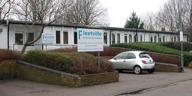
The temporary wartime children's nursery, today used by Fleetville Community Centre. The car is
parked where once a ramp and steel door led below ground level to emergency shelters for the
use of children at the school.

Two further installations during the war were an ARP hut next to the newly opened toilets, and an emergency water tank located where the zip wire is today.

Recent photo of the recreation ground without its original pre-war hedge line resulting from
road widening in the 1960s.

Plan prepared by Design Team Partnership in 1989 for a proposed underground car park for 194 cars under the recreation ground.  It would have occupied the southern end, but the proposal was not taken forward.

Post-war the junior children took to using the field for games lessons, but this was frowned on by the city council who wanted their bit field back from the County Council. A line of young trees were planted beside the shops, and in the 1960s a corner of the main road was shaved off and widened on safety grounds; resulting in the loss of the original field hedge with partial replacement of the original boundary wall.  Children living west of the rec will recollect an informal access point via a couple of missing railings next to Andrews' greengrocery.  That short cut disappeared with the improvements!

A scheme came to light in 1989 for a 200-car underground car park with ramp and six emergency staircases emerging at regular points in the field, as well as a number of light wells.  No one appeared to have considered the impact on organised events and team games.  Anyway, the plan was abandoned.

In more recent times there has been activity equipment for children and young people right across the park, and although the toilets were closed a popular cafe and seating area has appeared.

Next time we shall continue moving eastwards to the later developments between Royal Road and Tess Road (now Woodstock Road south). It might have become an entertainment hub!

Wednesday, 10 June 2020

A Boundary Road

Hatfield Road passes St Peter's Farm and bends right
after passing the pond in 1879.  This is pre-park and there
is no sign of Clarence Park Road.
COURTESY HALS
In the previous post we noted the impressive little corner building, Alexandra House, which became home to Barclays Bank until the late 1960s.  So far, however, we have only explored part of the former open space which was the frontage of St Peter's farm homestead and its cottage.  Land agent Dorant retained control of the corner plot for later development, and before proceeding further we need to ask questions about this corner, for until 1894 or thereabouts there was no corner, merely a bend in Hatfield Road.  In designing the layout of Clarence Park for John Blundell Maple a wide residential boundary road was created and along it a number of villas were proposed.  No doubt the intention was to claw back some of the expenditure on the park through these plot sales.  We'll return to the history of Clarence Park Road and Upper Clarence Road – as they were named – on another occasion.
The 1897 map shows Clarence Park Road and the park
 laid out, but no development surrounding the farm.
COURTESY NATIONAL LIBRARY OF SCOTLAND

If you have visited the park and left via the Clarence Road gate you might have taken in the view on the opposite site of the road (photo below).  This is what you would see: a 1920s detached dwelling to the right of Clarence Park Mews, with a gap-filling post-WW2 home on its left.  Thereafter begins the line of large villas.  The Mews was originally the cart entrance to the farm's barns and stores.  These survived and were rented out for furniture and other storage and in recent times have been converted for residential use.


View across Clarence Road, the space between the two houses was the
former farm cart track leading to the barns, now Clarence Park Mews.
Clarence Park Mews.
The space between the farm track and Hatfield Road was made available for development and three terraces of homes were built; each terrace had hung tiling at first floor level, arched front porches, and the end properties in each terrace slightly projecting with their front doors set back.  There were occasional references in the press  to the benefits of occupying a home opposite the park.

The Valuation Office records for the period up to 1915 show the block of land with their houses owned by W J Elliott of Chequer Street.  William Jermyn Elliott, born in the West Indies, was a piano dealer, whose shop was at 20 Chequer Street.  I am not certain whether he was also the developer of 2 to 30 Clarence Park Road or whether he acquired the estate after completion as an investment.  Today they remain largely as built, even showing evidence of small cellars and one or two original paths. A few still maintain little decorative front gardens, but most have utility gravel or pavers, bins, and car parking for small vehicles.


The terraces viewed from the park
(above) and from the road (top).

To the Hatfield Road end of the first terrace was added Alexandra House, which incorporated number 2 Clarence Park Road.  As an end of terrace dwelling it looks rather different from those on the ends of the other terraces.  Alexandra House consisted of a house and two shop units.  When the paint was hardly dry in 1903 the left shop was rented by chemist Frederick Fox who, for the previous nine years, had plied his trade on the corner of Laurel Road.  It seems likely Mr Fox saw the location of Alexandra House as not only closer to the homes in Stanhope Road, Clarence Road and Granville Road, but the wider corner location giving more visibility, even though he was moving further from the growing district of Fleetville itself.  Herbert Pike open his chemist shop between Sandfield and Harlesden roads after Mr Fox had moved downhill.  When Mr Fox retired from the corner the business was taken on by chemist partners Shields & Warren who remained until the 1970s, since when it transformed into a bridal shop.
The two retail premises and flat above.  Part of the bank premises appears to have included a basement.  The first
floor hung tiles from the terraces continue around the frontage.
COURTESY BARCLAYS ARCHIVE

The more prominent building with block facing is undeniably a bank which you would recognise as such even without the sign.  Opened just before WW1, it became the first such service in the Fleetville district.  Barclays moved further eastwards to the corner of Sandfield Road c1970, by which time all of the major banks also  had a presence here – before all of them left the district again. None of the new-style banks have arrived in their place either.  The Crown Barclays has had many transformations since, and is now a money transfer business.

So, in a period of fifteen years the wide frontage of the former farm's green space had been replaced by houses and shops; a period during which the whole of Fleetville between the Crown and the Recreation Ground and its parallel roads had been developed.


Tuesday, 2 June 2020

New Home in Hatfield Road

Last week we discovered the laurel shrubbery behind St Peter's Farm and the consequent naming of the short cut-de-sac.  This week we will find out what filled the space between Laurel Road and Clarence (Park) Road as the development estate got under way From 1899.
Alexandra House on The Crown corner.

Corner plots with a commanding presence often attract a premium price.  In this case the corner plot, with a view across the wide Crown junction and its new commuter houses in Stanhope Road, was snapped up by land agent Dorant and left as an open space for another ten years before becoming a residence, a shop and the district's first bank.  It was named Alexandra House.  Its boundary was where today's bus stop is located. But to start with the farm house and its cottage retained a view from its slightly elevated position over the Crown junction.  There was an open green with a path from the front door leading down past a pond towards Hatfield Road.

The green was now potential development land and the first block to be built on the green was an impressive terrace of four houses, with first floor hung tiles. This was Clarence Villas. The end homes had recessed front doors while the centre houses opened onto a minuscule front garden, still visible as the tarmac covering behind the footpath.  For the first decade there appeared to be no attraction in converting these cottages into shops.  After all, there were already established shops opposite, purpose-built retail premises newly opened in Stanhope Road, and the prospect of a post office and grocers replacing the former toll building.
Clarence Villas converted to shops

But the increasing popularity of this corner eventually led to  conversion of Clarence Villas to shops.  From west to east, the first was a garden produce shop (which might have meant a greengrocer), then a tailor, and for much of its life a cleaners. The second began as a jeweller but was well known as a greengrocer for much of its life. The third premises was a confectioner for all of its 20th century life, except for its first year when it sported the name many St Albans people were familiar with, Saxby Bros, a delicatessen.  The fourth house became another well-known name. Goody's (then taken on by Bugler's), the baker's and caterer's.  It was probably Clarence Villas  which established Hatfield Road as a shopping street, but it was beaten to change by the next block.
Three converted houses on the hill

It is believed the remainder of the green was also to have been built on straightaway, but the agents took a further three years to negotiate a sale agreement for the second block; these three properties were to be constructed on the hill itself.  They also began their lives as houses with bay windows, but were successful in conversion to shops before those at Clarence Villas – quite a coup for the time.  First was another confectionery, later becoming a hairdressing salon, then Mack's Store and finally a laundry.  Frederick Butler, a son of Ephraim Butler the butcher in St Peter's Street opened in the third premises in 1906, remaining there until the mid-seventies.
Showing the frontage as intended

To gain an insight into how the early houses were shown to the street, we can walk to the block after the entrance drive to the farmhouse, now the Conservative Club. The first two of three have remained a dentist and a doctor, and the slightly higher paving still in place was the original front garden.  The third property, now the Chicken Shop, originally the third of the trio, would also have had a ground floor bay window.  As a shop it began as Lupton's grocery  before becoming a picture framer and art shop – there are still many people who recall Mrs Young who ran the shop, having taken over from Harry Giddings.
Enamelled streetplate from 1906

Before moving on we may spot an original blue street plate fixed to the front wall of the dentist, although tree foliage hides it in season.  These plate were made by St Peter's Rural Council and reveals where the city boundary used to be until 1913, otherwise a street plate would have been installed on a property at the foot of the hill.

We have now reached the corner plot with Laurel Road, constructed in two parts, firstly the residential section for the corner shop owner, which was only converted to a fruiterer's shop in the 1930s, and the corner shop itself.  This was Arthur Hitchcock's cycle maker's until the mid-thirties, and then Mr Henderson's secondhand shop until conversion to Thresher's wine shop in around 1960.
From Laurel Road corner looking westwards

So that we don't lose our way, today the first block (Clarence Villas) are Ace Balloons, Menspire, The Carpet Store and Nino's.  The second block are Grill 'n' Fry, Launderette, and Madina General Stores. At the top of the hill are St Albans Dental Clinic, Doctors' Surgery, The Chicken Shop, Clarity Yoga Shala, and Thai Massage.


Wednesday, 27 May 2020

Laurel

The ladder roads on the north side of Hatfield Road, those between Harlesden and Blandford, are well-recalled by name, but there one other less well remembered street, although it leads nowhere except the ends of one or two Clarence Road rear gardens.  This is Laurel Road, one of those development roads which was intended to squeeze in a few extra small homes in an awkwardly shaped section of the site close to St Peter's Farm.  Although there is no remaining evidence for the street name, it is possible to search for it.  All we need is to return to the period prior to the development in the late 1890s.


Hatfield Road passes the farm in 1872.  Clarence Road will later be laid just
to the left of the pond; the shrubbery is to the right of the farm buildings.
COURTESY NATIONAL LIBRARY OF SCOTLAND
So clear all homes and shops from your mind – even the 1880s Cavendish estate. Stand, in your imagination, at the top of the hill in Hatfield Road and look down  towards what is now The Crown junction.  Here was yet another broad stream valley with its lowest ground from right to left into Camp Road.  Apart from a tiny turnpike toll building only one pair of buildings would be visible: St Peter's Farm and the adjacent St Peter's Farm Cottage.


Laurel Road c2012.  The houses in the background front onto Clarence Road.
They are still there in the form of the Conservative Club and Clarence Mews, the latter being a gated conversion of former farm outbuildings accessible from Clarence Road, opposite the main park entrance.  The farm buildings are not ancient in the sense of most farm homesteads; it appears that this was a farm holding created in the early 19th century.  But when built the land owner still felt it important to lay the homestead foundations on slightly elevated  ground on the eastern side of the valley referred to above – today we walk this valley side in front of the shops from the Crown corner towards Laurel Road.

With a change of tenancy in 1878 the farm buildings were advertised on the farm estate plan, along with its fields.  When the farm was sold in the late 1890s, there remained two homes available to sell or let which were already there, the farm and farm cottage.  The opportunity was taken to provide a name for this pair, and so they became known as Laurel Bank after the shrubs and trees growing behind the farm, as shown in the 1872 map.  It is from this landscape feature that the little road at the top of the valley side was named.
Estate map St Peter's Farm, 1878.  The owner has named the farm Ardounie
COURTESY HALS

The street directories at the time show that the first occupants were Mr G Mead (farm) and Mr H Pearce (cottage), but they was quickly followed by Edward Hansell, an architect and surveyor.  It is therefore possible that Mr Hansell was involved in the residential developments then being laid out along Hatfield Road.  Once most of the estate had been completed Laurel Bank became available once more and Mr Raymond Nelson, a draper and outfitter, lived and traded from the premises until the Conservative Club acquired the former farm c1946.


Hatfield Road in lower part of view; Clarence Road upper left; former farm and cottage behind the hedge in Hatfield Road.
Former outbuildings converted into a square Mews arrangement.  Laurel Road on right.  Former shrubbery between the
farm and Laurel Road.
COURTESY GOOGLE EARTH


While that may explain the naming of Laurel Road and its connection with the former farm, there is another name which is revealed in the 1878 farm estate map.  For while the Ordnance Survey map from six years earlier labels the buildings as St Peter's Farm, the farm estate map identifies the homestead as Ardounie.  This name is listed in the reference work Fairbairns Crests, although its specific connection with this location is unclear.

Next time we'll explore those homes and shops which filled the space between the newly laid out Clarence Park Road (as originally named) and that little Laurel Road at the top of the hill, passing the old farm on the way.