Showing posts with label ARP hut. Show all posts

Tuesday, 20 December 2022

Absent Collection

 During the past two months I have identified for everyone data on a range of buildings which no longer exist, and which from my research no-one thought to photograph, or if they did those pictures have not survived.  We therefore have little or no memory of what they might have looked like.

I've nowhere near finished this collection, but when I do I will offer reminders of buildings no longer existing but where, fortunately, photos were taken and still act as a point of reference for all of us.

Meanwhile, back to the challenge of locating buildings long since gone; not just one this time, but a whole group scattered around our East End.  Smaller than your average house and definitely not intended for permanent occupation; all erected in the late 1930s and demolished at various times in the 1950s.  They were variously street shelters, police cabins, and Air Raid Precautions Wardens boxes.  All constructed using stock bricks and with flat reinforced concrete roofs.

Street shelter surviving until at least the 1980s; not St Albans.

1946 aerial photo centred on Royal Road.  The orange boxed area shows the location of six
street shelters constructed on the west side of the roadway.


Street shelters built on the roadway of a city residential area; not St Albans.

Intending to provide emergency shelter to those caught in the road spaces when bomb warning sirens sounded, the last two surviving street shelters (though these were not actually on a street) remain on Fleetville Rec, part of the present Fleetville Community Centre and serving to protect nursery children and their teachers between 1942 and 1945.  The days of these old structures are now numbered as demolition is imminent, but we are fortunate in having a selection of archive photos, one of which is shown below.

Section of a surviving shelter at Fleetville Community Centre where it had sheltered nursery
children.  Section shows the side opposite the main entrance and the emergency escape hatch
with steps leading to the higher ground.

Among the structures demolished decades ago were street shelters in Beechwood Avenue (near Hatfield Road); Sandpit Lane (junction with Homewood Road); Sandpit Lane (The Wick); Colney Heath Lane (junction with Hatfield Road); Camp Road (junction with Campfield Road); Cambridge Road (junction with present Ashley Road); Clarence Park (football area); Sandpit Lane (junction with Lemsford Road); Royal Road (six in-line in the road space).

Of course, we might query why anyone in the 1940s would bother to take photographs of these rather plain and obviously temporary buildings, especially as most residents or travellers who were persuaded to shelter in any of them, will undoubtedly have negative experiences of the damp, dark and cold conditions, not to ignore how unsafe users might have felt sharing a dark windowless space with complete strangers.  

A police reporting cabin stood at the junction of Beechwood Avenue and Hatfield Road.
A street shelter was constructed nearby just to the left of the photo in Beechwood Avenue.
COURTESY PHILIP ORDE


The first reporting boxes were wooden and introduced in 1935.  The box shown above
was located elsewhere in St Albans, but an identical one stood on the west side of Sutton
Road opposite the Rats' Castle PH and close to the junction with Hatfield Road.  It
survived until replaced by the brick version in the upper picture in 1939.
COURTESY BT ARCHIVE
Police cabins were not so numerous, intending to be a reporting base for duty beat officers to avoid the necessity of returning to the Victoria Street police station at the end of a shift.  These cabins also housed a public telephone accessible from the outside.  Fortunately a photo is in the public domain of the Hatfield Road/Beechwood Avenue cabin before it was taken down.  What does not appear in the record is a photo of the early iteration of this brick box, which is the early wooden version on the Sutton Road/Hatfield Road corner; although the former GPO archive has an excellent picture of a similar cabin in a different district of St Albans.

Air Raid Precautions wardens were also provided with brick built boxes which acted as mini offices and provided with electric light and heating, and a telephone connection.  They were much smaller than a street shelter, but most of their locations have not survived human memory.  The former locations of four are certain: Beaumont School (driveway from Oakwood Drive); Fleetville Rec (next to the public toilets, now Beech Tree Cafe); Marshalls Drive (the Wick); and probably at Oaklands (location unknown).  It is also possible that two others existed, at the junction of Camp Road and Campfield Road, and at Windermere Avenue (where the north side Keswick Close homes are today).

So, the second question which needs answering: why would we need to retain images of these former inconsequential structures?  What value would they have for us now or in the future?  For the same reason former streams which no longer flow on the surface; stands of trees or wider woodlands which have long since been removed for their timber; or missing stone or metal milestones which are now obsolete, replaced by our widespread use of electronic maps and vehicle odometers.  

They represent individual items of the wider story of the district; they form the chapter headings for how life gradually changes as progress continues to be made; or as an immediate response to circumstances inflicted by outside circumstances.  When some of the evidence is permanently lost our understanding of a community is diminished.

So we will maintain our vigilance for the recovery of the historical record, won't we?

Wednesday, 27 July 2022

Beaumonts in 1946

 This week I am drawn to an aerial image I know so well, and I was already a toddler when the RAF photo reconnaissance planes flew over our house in the autumn of 1946.  This part of St Albans was my very own playpark: Beaumonts estate, although I can't remember many people using that name once the houses came out of the ground.  Because one of the first new roads to be laid was Beechwood Avenue I think we explained where we lived as being  "off Beechwood".


This week's RAF photo flyover in 1946 has picked out details of Beaumonts estate,
begun in 1929 and paused in 1940.  We can even see the continuation of the housing 
at the Willow estate south of Hatfield Road.
COURTESY HISTORIC ENGLAND


Not removed promptly after the Second World War was this circular emergency water
tank on the corner of Elm Drive and Oakwood Drive.  A house would occupy this corner in the
1950s but temporarily the tank enabled a water supply of sorts to be available (lemon yellow
circle).
COURTESY HISTORIC ENGLAND


Beaumont School in Oakwood Drive was completed in 1938, and the grounds
extended southwards to Hatfield Road a decade later.  The orange circles show
where the postwar HORSA classrooms would be added in 1947, the southern two on top
of the emergency underground shelter tunnels.  The boys' and girls' semi-outdoor
toilets are circled in red; and the ARP warden's brick hut (green) was next to the pedestrian
entrance from Oakwood Drive.
COURTESY HISTORIC ENGLAND


Today's much expanded school with little of the original playing field space left.  The 1938 
classroom block and halls, and the now enveloped former gymnasium further north help us to
navigate the site.
COURTESY GOOGLE EARTH

The first photograph shows Oakwood Drive, with Hatfield Road in the lower half.  These houses are already well-established, having been constructed in the 1930s, and the inevitable dislike of developers for building on many of the street corners resulted in pedestrian short cuts across future plots.  The second photograph highlights a circular shape on one of the corners (lemon yellow circle), between Elm Drive and Oakwood Drive.  This was one of the many emergency water tanks that had not yet been removed.  Not intended as a drinking water supply, but for fire fighting purposes in the event of dislocation of the public water supply during bombing.  On the eastern corner of that junction it gives the impression that  Elm Drive might continue, as indeed had been intended when the plans were first submitted to the council in 1929.  However,  in 1936 the County Council purchased the land for the school and this continuation of Elm Drive, and other residential streets, was unable to proceed.

Beaumont School was created behind the Oakwood Drive houses; the large rectangular classroom block intersected by the assembly halls and dining halls – one pair for each of the boys' and girls' schools, separated by floor.  The large building north of this was the gymnasium and changing rooms, and to the west was the workshop classroom.  In a few months would arrive three separate HORSA (Huts fOr the Raising of the School Age) buildings ready for when the leaving age was raised to 15 as authorised by the 1944 Education Act.  These would be erected on the land then previously used for the underground tunnel shelters for each school (orange circles) and an additional building north of the gymnasium.  The latter contained two classrooms used as the formative Fleetville Extension School (Oakwood JMI) in 1957.

Although outside school toilets had formally been dispensed with, those at Beaumont were not quite fully inside.  The small red circles show the location of the boys' and girls' toilets next to the respective playgrounds, each linked to the main building with an open but roofed walkway.  A further small (green) circled building was demolished in the 1960s, having been built specifically as an ARP warden hut during the Second World War.  Between south of the main classroom block and the playing field were, and partly still are, the school gardens.  Today the gardens are more ornamental, inspirational, but rather smaller.  During and after the war they were for vegetable growing and to support the County Council's pioneering Rural Studies curriculum.

Between the southern boundary of the field and Hatfield Road the photo shows a shrubbery not initially purchased by the County Council as it was intended to continue house building along Hatfield Road as well as an Elm Drive extension – referred to above – behind.  However, the school's upgraded requirements by the late 1940s meant the additional land was acquired to extend the field, with the exception of a strip adjacent to Hatfield Road on which was built the Bunch of Cherries public house, now the Speckled Hen.

The core of roads on the estate as developed in 1946.  The blue circle locates the temporary
war-time timber hut used by the local Home Guard Unit, whose members are pictured below. 
The turquoise circle locates the remains of the medieval moat surrounding a former Manor House.
COURTESY HISTORIC ENGLAND


See caption above.

Two images above shows Central Drive crossing from west to east.  The westerly Beechwood Avenue and Woodland Drive have been, or are being developed; Hazelwood Drive north has yet to be started and the Oakwood Drive north link towards Sandpit Lane was aborted.  None of the houses in Central Drive has been started in 1946, although we can see former tracks on each side of the newer roadway.  North of the Hazelwood Drive junction a small wooden hut remains (circled blue), which had served as the training hut for the local Home Guard Unit.
.

The farm house was demolished in 1938 and was situated immediately south of the foundations of the new houses on the east side of Woodland Drive north.

A young resident of Woodland Drive north in the front garden, with stacks of bricks ready to
build on the foundations of the homes.  This photograph was taken a few months after the RAF 
flyover.

The urgency to start new council house building has resulted in the footings for five pairs of homes in Woodland Drive north being laid (they being right opposite our 1939-finished house) and the remaining part of the moat in front of the medieval Manor House can be seen on the south side of Central Drive.  To the west of Beechwood Avenue and opposite to the newly created Central Drive remains the former farm lane, now called Farm Road, which was originally intended to be part of Central Drive to link with Beaumont Avenue.  It remains a private and unmade lane, although homes have somehow been shoe-horned into the space using parts of the original rear gardens in Beechwood and Beaumont avenues.

Beechwood Avenue, extreme left, with Woodland Drive north parallel, the latter joining the former as the beginnings of Chestnut Drive.  A rather rural Sandpit Lane runs west-to-east along the top of the 
photos and hidden behind the belt of trees.  Here are the extensive Beechwood Avenue Allotments, and further east is the playing field of what is now Verulam School in Brampton Road.
COURTESY HISTORIC ENGLAND


One of the temporary buildings (at least since c1900) on the corner of Beechwood Avenue and
Chestnut Drive was used for a short time as a Sunday school for St Paul's Church, serving the
children then growing up on the Beaumonts estate.
COURTESY SHEILA ARTISS

Tacchi & Burgess, a large building firm at the time, constructed about 20 houses on the south
side of Sandpit Lane on the edge of Beaumonts Farm.  It erected this bold sign along Hatfield Road
 to attract potential purchasers to the development in the 1950s.  
COURTESY PHILIP ORDE

The road at the bottom of the photo is Sandpit Lane, with the camera facing south and hovering over
Rose Walk.  The Tacchi & Burgess development spreads along Sandpit Lane lower centre.
COURTESY GOOGLE EARTH

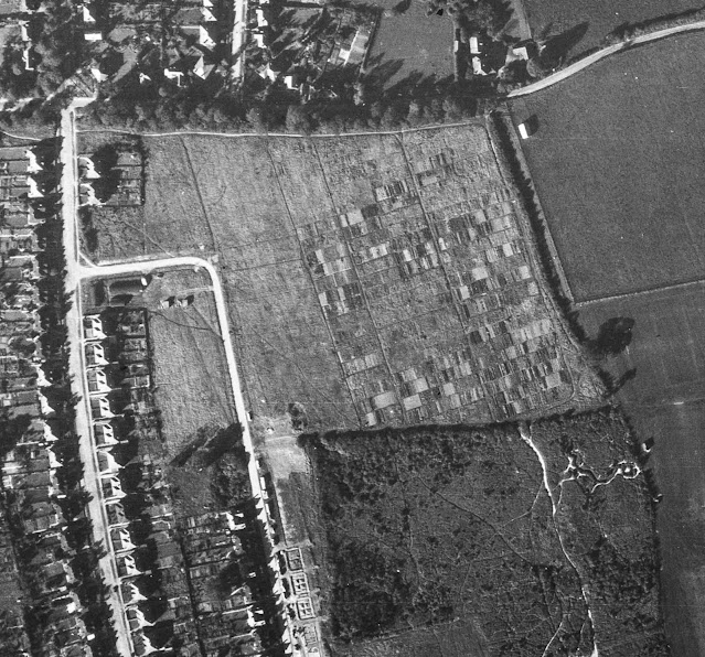
The third photo shows Beechwood Avenue and Woodland Drive north; the stub of a road joining them would later be extended to become Chestnut Drive.  At the Beechwood end of this road are three agricultural buildings, including two Nissen huts erected soon after  Beaumonts Farm was first sold to become part of Oaklands estate farm in 1899.  East of Woodland Drive north shows evidence of the large swathe of allotments, named Beechwood Avenue Allotments, leased by St Albans Council for the wartime period.  On one of these my father grew food for his growing family. By 1946 many of these plots were given up as the Council needed to hand the site back to land owner Watford Land Holdings, although some tenants were able to continue working their plots until 1948.

North of the allotments, and hidden by a narrow belt of trees, can be seen Sandpit Lane which was the northern boundary of Beaumonts Farm.  Sandpits was a rural lane at this point, there being no formal footpath, although the aerial photo identifies a footpath on the southern edge of the tree belt.  This was still accessible from Beechwood Avenue.  During the 1950s house builder Tacchi & Burgess removed the tree belt and constructed nearly 20 detached homes fronting onto Sandpit Lane.  The company erected a hoarding advertisement for the houses on the corner of Hatfield Road and Beechwood Avenue on a site which was previously a builder's yard for one of the house building companies engaged on developing the lower part of Beechwood Avenue.

Seventy or so years later, many of the homes have received extensions of one kind or another.  The pre-war developments were, of course, the last of homes with generous gardens on 30-feet wide plots.  The little unintended pocket park originally reserved for a church and shops, and then for a Bensons public house, instead was used for children's informal games before the arrival of the Central Drive shops and flats, and Irene Stebbings House.  Children do still have an open space to play on, but today the green in Hazelwood Drive is really an 'amenity space' – there remains the frame of a sign which in earlier times proclaimed NO BALL GAMES. 


Wednesday, 16 September 2020

For the People of Fleetville

Red: three fields formerly owned by the Grammar School.
Blue: field purchased by T E Smith for the Fleet Printing Works.
Orange: field purchased by T E Smith for his Fleet Ville housing.
Green: Part of the same field left undeveloped and acquired by Charles Woollam.


Recent aerial of the recreation ground during a dry summer period.
COURTESY GOOGLE EARTH

 We have now reached the end of St Peter's Farm where the property boundary lines up obliquely from the main road.  The former fields outlined in red on the above map identifies land which was owned by St Albans Grammar School and managed for it by the Verulam Estate.  The blue field was acquired by Thomas E Smith for his printing works in 1897 and he acquired the green and orange field opposite to lay out a hamlet for his employees.  

Others were also laying out streets and houses nearby on the former St Peter's Farm, and so Smith did not use all of his land – the green part of the field on the north side of Hatfield Road – otherwise there may have been a further street of two of small homes had the demand evolved.  You will see that there were no homes on the west side of Royal Road.

William Bennett, well known in the building trade, had rented at least part of the green field to store building materials, including bricks, which he needed for his construction activities in the Slade building estate.

In 1912 Charles Woollam, mill owner and a trustee of the Grammar School that had sold two of the three fields to Thomas E Smith in order to fund the expansion of the school adjacent to the Gateway, purchased the green field from the Smith estate using his own funds.  He had noted with some concern that Fleetville was growing quickly and no land had been allocated specifically as open space for the use of this district's residents. He gifted this land to the City Council in 1913, the year in which the authority had taken over responsibility for Fleetville from the Rural Council. A covenant protected the use to which it could be deployed, for the recreation of the people of Fleetville in perpetuity.  By name it was initially called Fleetville Pleasure Ground or Playing Field; later became known as Fleetville Recreation Ground, or Rec, but is now sometimes referred to as Fleetville Park.

No sooner had the council prepared the ground, built retaining walls and installed railings (some of which remain in place) than there was a call to dig it up for emergency allotments.  After some disagreements the allotments went instead to the field where Fleetville Junior School is today.

Pre-WW2 family photo, with the school as a backdrop.  This was before the recreation ground
railings were removed on this side.  Today the seat is occupied by part of the front of the
Community Centre.
COURTESY FLEETVILLE INFANT SCHOOL & NURSERY


For the next 25 years the Rec was rather bland with just one set of children's swings near the Royal Road corner (chain locked on Sundays as was the custom in St Albans); and a public toilet block added in 1938, the same year in which emergency zig-zag trenches were excavated in preparation for war.  Gates in the fencing at bottom of Burnham Road gardens enabled quick access to the trenches.  Additional trenches were added in 1939 and 1940 for the benefit of the school; all were deepened to 8 feet, bricklined and covered, and fitted with electricity, heating and telephone.  They were accessed from steel doors at Royal Road with an emergency exit in the rec field, the latter can still be noticed in parched grass in hot dry summers.  A temporary day nursery arrived in 1942 for the benefit of mothers who worked in the munitions factories locally – this building is still in use as the Community Centre.  

A 1939 aerial of the recreation ground in the middle.  The 1938 open zig-zag trenches are visible.
So too is the diagonal footpath between the Hatfield Road and Royal Road gates. Within that
triangle is the new public toilets block and the children's swings.  Also clear is the grass wear from games of football!
COURTESY HERITAGE ENGLAND

The temporary wartime children's nursery, today used by Fleetville Community Centre. The car is
parked where once a ramp and steel door led below ground level to emergency shelters for the
use of children at the school.

Two further installations during the war were an ARP hut next to the newly opened toilets, and an emergency water tank located where the zip wire is today.

Recent photo of the recreation ground without its original pre-war hedge line resulting from
road widening in the 1960s.

Plan prepared by Design Team Partnership in 1989 for a proposed underground car park for 194 cars under the recreation ground.  It would have occupied the southern end, but the proposal was not taken forward.

Post-war the junior children took to using the field for games lessons, but this was frowned on by the city council who wanted their bit field back from the County Council. A line of young trees were planted beside the shops, and in the 1960s a corner of the main road was shaved off and widened on safety grounds; resulting in the loss of the original field hedge with partial replacement of the original boundary wall.  Children living west of the rec will recollect an informal access point via a couple of missing railings next to Andrews' greengrocery.  That short cut disappeared with the improvements!

A scheme came to light in 1989 for a 200-car underground car park with ramp and six emergency staircases emerging at regular points in the field, as well as a number of light wells.  No one appeared to have considered the impact on organised events and team games.  Anyway, the plan was abandoned.

In more recent times there has been activity equipment for children and young people right across the park, and although the toilets were closed a popular cafe and seating area has appeared.

Next time we shall continue moving eastwards to the later developments between Royal Road and Tess Road (now Woodstock Road south). It might have become an entertainment hub!