Showing posts with label Woollam C. Show all posts

Wednesday, 16 September 2020

For the People of Fleetville

Red: three fields formerly owned by the Grammar School.
Blue: field purchased by T E Smith for the Fleet Printing Works.
Orange: field purchased by T E Smith for his Fleet Ville housing.
Green: Part of the same field left undeveloped and acquired by Charles Woollam.


Recent aerial of the recreation ground during a dry summer period.
COURTESY GOOGLE EARTH

 We have now reached the end of St Peter's Farm where the property boundary lines up obliquely from the main road.  The former fields outlined in red on the above map identifies land which was owned by St Albans Grammar School and managed for it by the Verulam Estate.  The blue field was acquired by Thomas E Smith for his printing works in 1897 and he acquired the green and orange field opposite to lay out a hamlet for his employees.  

Others were also laying out streets and houses nearby on the former St Peter's Farm, and so Smith did not use all of his land – the green part of the field on the north side of Hatfield Road – otherwise there may have been a further street of two of small homes had the demand evolved.  You will see that there were no homes on the west side of Royal Road.

William Bennett, well known in the building trade, had rented at least part of the green field to store building materials, including bricks, which he needed for his construction activities in the Slade building estate.

In 1912 Charles Woollam, mill owner and a trustee of the Grammar School that had sold two of the three fields to Thomas E Smith in order to fund the expansion of the school adjacent to the Gateway, purchased the green field from the Smith estate using his own funds.  He had noted with some concern that Fleetville was growing quickly and no land had been allocated specifically as open space for the use of this district's residents. He gifted this land to the City Council in 1913, the year in which the authority had taken over responsibility for Fleetville from the Rural Council. A covenant protected the use to which it could be deployed, for the recreation of the people of Fleetville in perpetuity.  By name it was initially called Fleetville Pleasure Ground or Playing Field; later became known as Fleetville Recreation Ground, or Rec, but is now sometimes referred to as Fleetville Park.

No sooner had the council prepared the ground, built retaining walls and installed railings (some of which remain in place) than there was a call to dig it up for emergency allotments.  After some disagreements the allotments went instead to the field where Fleetville Junior School is today.

Pre-WW2 family photo, with the school as a backdrop.  This was before the recreation ground
railings were removed on this side.  Today the seat is occupied by part of the front of the
Community Centre.
COURTESY FLEETVILLE INFANT SCHOOL & NURSERY


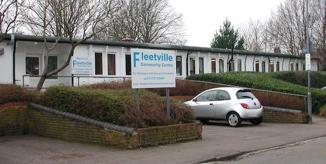
For the next 25 years the Rec was rather bland with just one set of children's swings near the Royal Road corner (chain locked on Sundays as was the custom in St Albans); and a public toilet block added in 1938, the same year in which emergency zig-zag trenches were excavated in preparation for war.  Gates in the fencing at bottom of Burnham Road gardens enabled quick access to the trenches.  Additional trenches were added in 1939 and 1940 for the benefit of the school; all were deepened to 8 feet, bricklined and covered, and fitted with electricity, heating and telephone.  They were accessed from steel doors at Royal Road with an emergency exit in the rec field, the latter can still be noticed in parched grass in hot dry summers.  A temporary day nursery arrived in 1942 for the benefit of mothers who worked in the munitions factories locally – this building is still in use as the Community Centre.  

A 1939 aerial of the recreation ground in the middle.  The 1938 open zig-zag trenches are visible.
So too is the diagonal footpath between the Hatfield Road and Royal Road gates. Within that
triangle is the new public toilets block and the children's swings.  Also clear is the grass wear from games of football!
COURTESY HERITAGE ENGLAND

The temporary wartime children's nursery, today used by Fleetville Community Centre. The car is
parked where once a ramp and steel door led below ground level to emergency shelters for the
use of children at the school.

Two further installations during the war were an ARP hut next to the newly opened toilets, and an emergency water tank located where the zip wire is today.

Recent photo of the recreation ground without its original pre-war hedge line resulting from
road widening in the 1960s.

Plan prepared by Design Team Partnership in 1989 for a proposed underground car park for 194 cars under the recreation ground.  It would have occupied the southern end, but the proposal was not taken forward.

Post-war the junior children took to using the field for games lessons, but this was frowned on by the city council who wanted their bit field back from the County Council. A line of young trees were planted beside the shops, and in the 1960s a corner of the main road was shaved off and widened on safety grounds; resulting in the loss of the original field hedge with partial replacement of the original boundary wall.  Children living west of the rec will recollect an informal access point via a couple of missing railings next to Andrews' greengrocery.  That short cut disappeared with the improvements!

A scheme came to light in 1989 for a 200-car underground car park with ramp and six emergency staircases emerging at regular points in the field, as well as a number of light wells.  No one appeared to have considered the impact on organised events and team games.  Anyway, the plan was abandoned.

In more recent times there has been activity equipment for children and young people right across the park, and although the toilets were closed a popular cafe and seating area has appeared.

Next time we shall continue moving eastwards to the later developments between Royal Road and Tess Road (now Woodstock Road south). It might have become an entertainment hub!

Sunday, 15 September 2019

Engaging With Our Locality

Whenever families, individuals, classes at school and visitors to the district, are able to share in some of the history of their home district, the experience is always positive.  More than that, what we discover is quite joyous.

Heritage Open Days have proved the point once more, although other casual meetings throughout the year have a similar effect.  September and October is also the period of time in the school curriculum when children explore their home patch, both the school itself and the shops and homes, where we and our friends live and what we can buy at the shops.  It is therefore a delight to meet the children as they find out how the school day was conducted, how children behaved and the playground games they may have played fifty or a hundred years ago.
Fleetville School playground in the 1930s.

Throughout the year members of Fleetville Diaries carry out deeper explorations in the form of projects.  St Albans had been the home of Frederick Sander and his renowned orchid nurseries in Camp Road, and this formed the basis of a major project last year.  Its culmination was to share our findings in a glorious celebration with members of the Sander and Moon families today (Henry Moon turned Sander's orchids into exquisite watercolours).

This year the organisation has taken Beaumont Avenue as its next subject in the series Right Up Our Street; and to focus on the former hosiery mill, Ballito, which grew on the site now occupied by Morrison's, where thousands of local men and women came to work, both in peacetime and war.  Although largely based on recollections it has been important to understand how the factory came to Fleetville in the first place.

Heritage Open Day on Saturday 14th September was an appropriate occasion to bring people together, to view three exhibitions and chat with the project leaders, to do so in a building (Fleetville Community Centre) first erected in 1942 as a nursery for the young children of women encouraged to work at the Ballito works that had been turned over to making shell casings for the war effort.

Factory managers' houses in Woodstock Road south
It comes as a surprise to many that competitive circumstances dictated the original Fleet Ville did not realise its full potential and which may otherwise have become a good deal larger.  The fact that it did not enabled one of this city's major benefactors, Charles Woollam, to acquire the field left over for the recreation and enjoyment of the people of Fleetville in the form of the Rec, or as many people refer to it these days, Fleetville Park.


Summer view of The Alley.
We then take a short guided walk around early roads; are amazed that Fleetville had a unique cinema – where no-one was fortunate in watching a film there; stood on the spot where several WW2 spies were charged, discover the homes built for the factory employees in one road and those built for its managers in another; and the function of The Alley which most Fleetville folk claim never to have walked along.  There are parts of Fleetville, too, which are more ancient than the Cathedral, and a stream to cross without getting our feet wet!

People love to ask questions and are often amazed by the answers; almost always a conversation ensues.  We are all part of a community and feel a personal responsibility to learn more about it.  And it matters not whether you are a 9-year-old who has already made sense of where he lives, or an adult who has lived here for three times as long and come to realise it's no longer sufficient to take local history for granted.

One way or another we all yearn to become more involved.