Showing posts with label Sandfield Road. Show all posts

Sunday, 19 December 2021

The End of Our Road

 Recently I rediscovered a postcard photograph from circa 1914  showing off an almost new Glenferrie Road.  The street looked smart!  The photographer had set up his tripod in the middle of the road, probably halfway along the road, and his camera faced towards Hatfield Road.  The only sign of life captured was a road sweeper with his barrow, and I noted how wide the public space appeared to be; no parked cars, of course, and the footpaths were equally clear of rubbish bins, skips, data connection boxes, parking signs or  telephone wires carried on their sturdy posts.  And no white lines on the roadway or coloured spray paint on the pavement.  Litter? Not a wrapper to be found.  In this view just one small street light is  visible, and, if you look carefully, one posting box on the corner where the future Methodist Church will be built.

Many more pedestrians would have been be walking in one direction or the other, and as this photo was facing Hatfield Road, everyone's major view was about twenty feet of the south side of Hatfield Road unhindered by today's obstructions; the growing trees of the cemetery and a field tree predating the cemetery but now removed.  This was a fixed and identifiable scene with which householders were familiar.  East street end had, and still has, is own unique borrowed picture of the next road.  Unfortunately, similar photographs are not available of all of Fleetville's roads, and although today's roads are crowded I thought it might be useful to find Streetview images of nearby residential roads and focus on their own end of road fixed views.


The widest view presented to us is in Clarence Road just south of the park's main entrance; a view not much changed since 1900 – The Crown and the Stanhope Road shops.  Only the former post office, now Chilli Raj, is slightly newer.


Laurel Road may be short but provides same amount of view: Rose Cottage (the one with the cart drive under part of the house) and the first of the three Horndean Cottages just before Cavendish Road.


By the time we reach Blandford Road, the view is one of the views which include mature trees. We just miss seeing the main entrance to the cemetery, and just behind the frontage wall and trees is the entrance to the Manager's lodge.  Blandford Road emphasises the difficulty of cars passing each other while parking occupies both sides of the road and two-way working.

Glenferrie Road today, as one hundred years previously, provides us with a green backdrop to Hatfield Road, being at the eastern end of the cemetery.  The trees have grown more majestic and there are no buildings behind to be masked.  It can't of course be helped that this was the day the bins were collected.  Nevertheless most of the containers remain on the footpath all day and make it difficult for pedestrians generally, those in buggies and with sight or other mobility issues, to negotiate a route between garden walls and kerb-parked cars.


At Sandfield Road we are able to look across to the drive of Rainbow House, formerly the Family Centre, and the frontage of Magnet Kitchens.


The former Hobbs Garage comes into view at the end of Harlesden Road.  These days it belongs to Kwik Fit, of course. And we can just see part of the caretaker's house which was erected c1935 for the Central Girls' School, part of the roof of which can be spotted above the Kwik-Fit building.


An especially green south of Hatfield Road is apparent opposite Royal Road where the backdrop of Morrison's car park is Alban Way.  We are led to this view via the welcome tree lined recreation ground.


A hedge-line borders Woodstock Road south at Fleetville Nursery and Infants School and contrasts with the first of two views of Morrison's supermarket, which is probably a more pleasant streetscape than that of the former Thomas Smith printing works structure (also retained by Ballito Hosiery Mill).  Many would consider that building to have appeared more austere.


Finally, from way down Arthur Road we capture the glazed wall of  Morrison's cafe.  We are also deceived by the sight of a tree which looks as if it is growing on the corner site of the old Institute building, although it is a borrowed view; it is growing in the grounds of Morrison's, near the corner of Sutton Road.  We finish with a 1953 monochrome photograph showing the earlier view from Arthur Road across to the Ballito building.  We can colour it in our imagination as we prepare for our 1953 Coronation street party.

We can, of course, find views from the ends of almost every road in the city.  What connects the selection shown above is of course the busy Hatfield Road.

Photos courtesy St Albans Museums and Google Streetview.


Sunday, 7 November 2021

Community Football

 This week we are going to unpick a few community football issues from the very early years of our East End, and we begin with what is believed to be the first known amateur team which was formed c1890 from the residents then living in the new homes east of the Midland Railway, Cavendish, Albion, (upper) Camp, Stanhope and Granville roads.  A club by the name of Stanville FC was formed, the portmanteau name using Stanhope and Granville in its name.

Stanville FC adult team (there was also a reserve and junior squad) c1897.  However the setting is
not identified.  The gentleman centre back row is undoubtedly Thomas Oakley, who in this year was Mayor of the city.  Whether Mr Oakley had a formal connection with the club is not known, but he was present on this occasion!
COURTESY CHRIS REYHOLDS

Stanville's name appeared regularly in 1890s editions of the Herts Advertiser, playing other district teams, such as Abbey, Hatfield, Campfield (after 1995), Harpenden and Redbourn.  A report on one match in 1891 describes a home game played on its home ground in Hatfield Road.  This tantalising fact is set to test us.  Clarence Park is still three years from its opening, although the field from which the Hatfield Road side of the park was created had previously been a meadow known as the Fete Field and available for public events by the city's residents.  Another possibility was part of a field just east of St Peter's Farm.  The 1898 OS map shows unbuilt land on the corner of Stanhope and Camp roads, the green in front of St Peter's Farm, and a corner site on Hatfield and Lemsford roads. Perhaps these plots
were rather small for such a game.

How long the Stanville club lasted is uncertain, but the Adult School which opened in Stanhope Road in 1911, soon created its own football team, under the management of one of its members, Charles  Tuck, who ran a motor garage business in Hatfield Road, east of Sutton Road.  We might speculate that players from Stanville moved over to the Adult School team if some of their friends also transferred, or perhaps Stanville Club closed in favour of the Adult School.

The St Albans Adult School team from 1921, taken outside the School in Stanhope Road.
The team trainer/manager, Charles Tuck, is on the left of the middle row.

We know of another community street football team thriving in 1911, Glenfield FC – another portmanteau from Glenferrie and Sandfield roads, where the majority of their players are thought to have lived.  Once more, we have little idea of the lifespan of the Glenfield team and whether it was able to manage the frequent transfer of residents living in the rented homes in that part of Fleetville.  No doubt, as with other local teams, good or enthusiastic teens and adults from further afield would be encouraged to participate.

Another street football team was Glenfield FC, where many of the players lived in Glenferrie or Sandfield roads.   

We are, of course, not surprised by the existence of a football team in part of Fleetville in 1911; after all much of Fleetville east to Beaumont Avenue was either complete or in build before the First World War.  Whether such teams were able to re-form in the 1920s is uncertain.

However, there is an intriguing announcement in the Herts Advertiser during September 1898: the fixture list for that season up to the following April.  The list was headed Fleetville FC !  So, let's discover where the name Fleetville came from.  The printing works was in build during 1897, was completed during 1898 and named The Fleet Works, after the company's London address at the lower end of Fleet Street.  The rest of 1898 was taken installing machines and searching for a small number of skilled employees, although there were no houses closer than Cavendish Road, and Camp district was empty other than Camp Hill.  Factory owner T E Smith laid out plans for his Ville of workers' homes opposite the works, and placed advertisements for builders from 1899.  The name of the proposed development was initially Fleet Ville.  It would be a further year before a small number of homes in Arthur and Tess roads became habitable, and a year later than that when a few homes on the Slade building estate were also ready.

This photo of c1911 shows the locality which had been first identified as Fleet Ville and then as
Fleetville from 1898.

To have a ready name, Fleetville, for the residential district seems to us far too early, but ready it obviously was; to have sufficient residents, both adult and junior, ready to form teams also appeared far too early, but ready they obviously were.  In September 1898 the team – under whose management we know not – applied for affiliation to the district Football Association, which was accepted.  The Association had already received entries for the Cup from the following teams: St Albans A team, Campfield (probably from the Orford Smith printing works), Abbey, Harpenden, Elstree, Ware Excelsior, Stanville, Hatfield and Fleetville.

At the end of the first half of Fleetville's first season the Herts Advertiser announced that a member of its junior team was to be censured and cautioned for disorderly conduct during a cup match against Stanville FC – a local derby!

September 1898 was probably the first occurrence in the newspaper of the name Fleetville.  The usage of place names not officially titled and created, usually takes time for people in a locality to become acquainted with such words which enter the common language naturally.  Fleetville apparently entered the local lexicon far earlier than we had all imagined.


Monday, 5 July 2021

Road to Nowhere

In the 1930s, travelling between Camp Road and Hatfield Road, perhaps to benefit from the latter's shopping facilities was far from a short hop; the only two options being Ashley Road and Camp Road (Crown end).  The council, despairing of successfully negotiating with the railway company to get an improved Sutton Road, turned its attention to something new.  At the time, there remained purchasable space in Hatfield Road opposite Sandfield Road and in Camp Road where Roland Street was laid. But the proposed road would still need to cross the railway – under, over or via a crossing.  Finance and practicability eventually aborted the scheme.  Today, connectivity between Camp Road and Fleetville remains an issue.

Section of Hatfield Road in 1937.  The premises of Leon Turner (see previous post) is outlined in
red.  The access drive (green) leads to Rainbow House today.  Clifton House Garage (orange)
stood here and is now replaced by Magnet.  The blue site became Grimaldi's Garage and is now
part of the Magnet and Topps Tiles businesses.  The proposed new road would have emerged
in the green space shown above.
COURTESY NATIONAL LIBRARY OF SCOTLAND

To the west of the former DIY Centre of Tucketts and Leon Reed there was a block of land joining Hatfield Road and the playing field of the school behind.  When Hertfordshire Council acquired the land only the eastern portion was used initially and it took the precaution of acquiring three access points: the original pedestrian entrance to the school, the 1930s vehicular entrance nearly opposite Harlesden Road, and a wide entrance at the western end for future educational use.  A small modern unit was indeed constructed in recent times as a Family Centre. Most recently it became Rainbow House, an adoption centre.

At the end of the drive is the building for Hertfordshire County Council's Family Centre, and
is now Rainbow House.

A plain and quiet building (orange on the map) was erected during the 1930s and became an adjunct of the thriving business of J B Rollings whose premises, Clifton House, were nearby on the north side of the road.  As a wholesale confectioner and tobacconist a garage was required for the storage of its vehicles.  Its doors were rarely open and the only clue as to its function was a sign across the front: Clifton House Garages – although there was only one such building. 

On the left is the intended driveway to the school field, then fenced off.  The garage belonging
to J B Rollings, wholesale confectioner, comes next, followed by the frontage of Ernest
Grimaldi's garage.  The two floor building beyond is Papa Johns and formerly Calverstone,
a military hat manufacturer.
COURTESY ST ALBANS MUSEUMS

The next plot (blue on the map) was an awkward, almost triangular, shape resulting from a bend in the road.  Although first purchased before the First World War the land lay empty until c1937.  During that period it was the property of Camden Brewery – no connection with the present Camden Town Brewery. 

When Ernest Grimaldi came to St Albans from Devon he was already an experienced motor engineer and obtained a position at W M Couper's car sales in Catherine Street.  Grimaldi and his two sons formed a family motor business and dealership making use of the awkward shaped plot mentioned above.  The buildings, though not extensive, were built in the modernist style of the day, and in addition to the workshops a flat was built into the first floor.

Part of the forecourt of Grimaldi's Garage showing one of the modernist style glazed pillars.  The building beyond is the former Calverstones building and then a garage belonging to Mr White.
COURTESY ST ALBANS MUSEUMS

The forecourt dispensed petrol, and a pair of glazed decorative pillars of internally lit ribbed glass marked the entrance and exit. They were topped with Shell petrol's logo, also internally lit. The business was closed during World War Two; Ernest joined the Royal Observer Corps while the boys entered regular service.  The family partnership  after the Peace, minus Ernest's elder son who was killed in 1942.  With no space on the garage site the car showroom began in a small way on the corner of Sandfield Road but later removed to the Victoria Hall building in Victoria Street.

When the business closed the site, and that of Clifton Garages, was redeveloped into the Magnet and Topps Tiles premises.

Clifton House Garage and Grimaldi's Garage are both replaced by Magnet and Topps Tiles.

Ernest was descended from the illustrious European family of Grimaldi (Grimaldo), whose disputed seat was Monaco, and whose line extends back to the eleven hundreds.  We will shortly reach the location where Ernest was laid to rest in Hatfield Road Cemetery, but we have a political centre to call in at first.

Friday, 14 August 2020

Squeezing One More In

 Continuing our detailed virtual walk along Hatfield Road, and in some cases imagine we are early residents exploring the "mile of shops", last time we had reached Sandfield Road.  The next block now takes us as far as Harlesden Road, although there is sufficient material this time to proceed roughly halfway – twelve properties  would be too many for a single post!  However, the perfect photo to begin with is Andy Lawrence's newly acquired picture of what the photographer had termed "The Promenade".

A c1912 photo of the properties between Sandfield and Harlesden roads.  Sun blinds are
prominent, with Mr Gibbs showing a corner version to further highlight the location of his
shop.  Note the three first floor bays nearest Sandfield Road, one of which is missing in a
later picture below.
COURTESY ANDY LAWRENCE

Since we left Glenferrie Road we would have been, in an earlier time, at the hedge line looking into a field formerly known as Long Moody, and already, by 1902, the corner plots now have buildings on them. At Sandfield Road this was a fine shop owned by Samuel J Gibbs who aspired to furnish the tenants and owners of the homes then being built around him.  As a corner shop he was able to display two full windows, and as intended the Gibbs family lived above the shop.  But as he became more successful the shop began to expand upstairs.  Around 1910, Mr Gibbs therefore purchased number 4 Sandfield Road behind the shop – not far to travel to work! It was, in fact the only house, close to the Hatfield Road boundaries; otherwise land remained open until number 20, so what happened to number 2?  Well, on the 1922 map a house seems to have been constructed on the rear garden of number 4.  Perhaps an initiative of Mr Gibbs who felt he did not need a rear garden.  So, even in those early days of the district extra houses were already being squeezed in!

Mr Gibbs handed the business on to Henry Lewis, and by the mid thirties Mr Graham Henderson opened a "curios and oddments shop" here, before moving it along to the Laurel Road corner after the war.  The biggest change came with the re-forming of the Grimaldi business in the early days of peace, and its petrol and car maintenance business was augmented by a Rootes car sales showroom at number 149.  Yes, two band new cars could be displayed inside the shop.  Fleetville went into car sales!  For a while you could purchase refrigerators and freezers from here, before Barclays upgraded the premises and moved its bank from the Crown, which it clearly felt was advantageous for business.

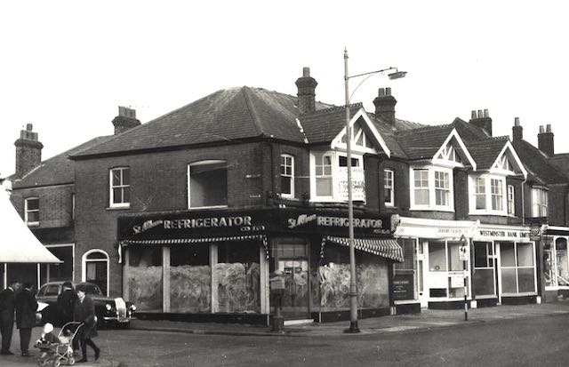
Here is number 149 on the corner after the occupation of St Albans Refrigeration in the 1960s.
A pillar-style police call box stands on the pavement corner, and we are just a short time before
new-style road signs.  Every change of occupant, it seems, has brought a different side facade
on the Sandfield Road frontage.
COURTESY ST ALBANS MUSEUMS

The arrival of Barclays Banks has also created modernised and smart external frontage.  For
the first time the building is without its first floor bay window.
COURTESY BARCLAYS ARCHIVE

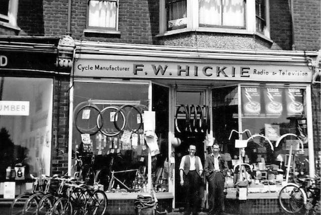
The next pair of shops came four years later, but were undoubtedly built by the same company as the corner shop.  Today, however the cohesive design is lost as the first floor bay window was removed in the later conversion to bank premises. Although number 151 spent some decades in George Weatherhead's care as a china shop, and then Charles Chuter for outfitting, undoubtedly the most well-known owner began here during the Second War: Frederick W Hickie.  When petrol is in short supply people turn to their bikes; then radio continued its popularity and we became curious about the new television service, Mr Hickie and his son were happy to serve.  Since the mid-sixties insurance and legal services have ventured into the suburbs to demystify one of life's needs which had formerly been found in the side roads of the city centre, sometimes above shops.


Hickie's bicycle and radio/tv shop in the 1950s, with father and son at the doorway.
COURTESY THE HICKIE COLLECTION

The complete development as it looked in 2012.  Again, the first floor bay window and projecting
eaves are now absent.

Number 153 was one of the first shops to break away from from the notion of each trader having his or her own single shop.  Charles Chuter ran his outfitter's from two adjacent properties from the 1920s, thereby signalling that retailing often needs a variety of footprints to work in.  Soon after the war Westminster (later NatWest) moved to join other chains in serving Fleetville, and in recognition of its success, later moved to larger premises which we met last time on the west corner of Sandfield Road.

Number 157's first occupant was James Andrews who sold the comprehensive range of
accessories, fitments and finishings to homes the company had built.  This would later
become Percy Stone's newsagent's shop.
COURTESY (name temporarily mislaid – to follow shortly)

The next pair of shops was clearly intended for a specific purpose.  James Andrews owned a building business.  He had acquired land on the opposite side of Hatfield Road for his builders' yard.  The righthand shop was in the care of his wife for the sale of builders and finishers accessories – and no doubt became the firm's office.  To the left of the central vehicle arch a shop was available to let, which provided a regular rental income; a trade which, until the 1970s, served as one of Hatfield Road's regular and frequent grocery shops.  Peep through the arch next time you are passing and the service buildings to the rear are still in regular use by the present occupiers of both shops: SK Carpets.

James Andrew's shop was on the right, but he owned both shops with access to workshops
through the arch; the left shop was let to a succession of grocer's.

Number 157's longest owner was was also one who had three successive trading addresses and saw Fleetville's very birth. Percy Stone's first store was where the Rats' Castle is today.  He later moved to Bycullah Terrace, before moving again to 157. Although generally known as a newsagent's we would recognise its product range in any newsagent's we walk into today (except perhaps the lottery tickets). There are many former teenagers who will recall their daily roles as paper boys, propping their bikes against the wall under the arch before climbing the steps into the shop.

It is along this section of Hatfield Road where the feature of the ground floor front elevations follow the street line, while the first floors are turned to face due south.  Although the two shops at 155 and 157 are modest in floor area, space being reserved for the arch, the first floor accommodation over the arch provides some compensation.


Friday, 7 August 2020

Oak Villas and a greengrocery

Between 1900 and the First World War the pace of building development on the north side of Hatfield Road was brisk, and at any one time there would be some construction happening in all of the streets, and naturally many builders were interested in plots facing Hatfield Road.  In this collection of posts the focus is on houses and shops; we'll return later for the story of the churches.
The area bounded by the red box identifies the Hatfield Road buildings in this post.  The centre pair
are Oak Villas; the left pair are Emerton's shops; the right was Mr Hills' house; finally the two spare
plots between.
COURTESY NATIONAL LIBRARY OF SCOTLAND

In travelling eastwards from The Crown the focus is now on the site between Glenferrie and Sandfield roads. In 1899 George Emerton took a look and became interested in two plots right in the middle.  We don't know whether that was coincidental or whether there was some symmetry at work.  But the outlook across the road was towards the field east of the Cemetery, rather than the burial ground itself.

Oak Villas 1 and 2 with a more modern front garden wall which obscures part of the front bay
windows.

What resulted was a semi-detached pair of houses, solidly built, with doors adjoining, the usual minimum width front garden, and named Oak Villas 1 and 2.  So who lived in them?  According to the street directories George Emerton himself lived in number 1 until 1910, and various tenants in number 2.  The Valuation Office record indicates there were workshops (plural) behind number 1, as if he was using Oak Villa 1 as a base for his building work.  Sisters Olive and Lily Emerton moved into number 2 in 1938 and remained resident until c1973. Equally interesting, number 1 was occupied by P Osborne for a short time and then Henry Jagels.  Their story is followed up below. But in recent years both villas have been converted in a Mosque.

From left to right, the two shops, Oak Villas 1 and 2, and the remaining spare plot. The first shop
blind shades Mr Davies' Toys and Sports shop; finally the original Hills' house, converted into jewellery and later a wool shop.
COURTESY ST ALBANS MUSEUMS

In the meantime, the Valuation Office reveals George Emerton also acquired two plots to the west of Oak Villas.  In c1910 Mr Emerton raised two shops on these plots, which became 135 and 137.  Several Fleetville residents recently noted building alterations taking place and a pair of former shop fascia signs were revealed from an earlier period. 

Until the end of WW1 number 135 apparently remained empty, and then Miss O Emerton managed a confectionery shop there, before being let to a tailoring business.  From 1960 it was home to general engineers and instrument makers and in recent times was the location of a Credit Union.  Number 137 had been a greengrocery from 1912 onwards, firstly by the Osborne brothers, and then by the Jagels family. Henry Jagels and his wife lived in Oak Villa 1, and their son Frederick came to take over the greengrocery from the Osborne brothers.  The upstairs flat was not adequate for a family and as they are believed to have raised three children, the family lived in a house at the Brampton Road end of Glenferrie Road.  The greengrocery was thought to have remained Osborne's, even though it was managed by the Jagel family for over twenty years.  This would might account for the fascia sign.

Recent renovations reveal the former fascia sign for the greengrocery under the management
of the Osborne Brothers
COURTESY PETER ELLIOT

Around two years after Mr Emerton's arrival a house was constructed on the west corner of Sandfield Road.  It was quite narrow and was acquired by Mr Henry Hills.  He was another Hatfield Road occupier who relished the benefit of turning his ground floor into a shop to advance his jewellery trade.  Subsequently it became a drapery and a house furnishing shop.  From 1949 Mr Davies moved in to supply the increasingly popular wool trade, and until 1956 two plots between this shop and Oak Villas remained unused, which is a long period for an otherwise busy district shopping street.  But in that year Mr and Mrs Davies created an extension to the original shop on the corner and opened the ground floor as St Albans Toys & Sports.

A surprisingly spacious Sandfield Road c1912.  On the right is the side-facing living
accommodation of the corner house of Henry Hills.  Unfortunately I have not yet been able
to located a photo of the house frontage or the first version of the shop. The original 1906 Rural
Council street plate can just be seen to the left of the the first floor drain pipe on the east corner.
COURTESY ST ALBANS MUSEUMS

By 1975 the Davies's had handed the property over to Westminster Bank/ National Westminster Bank, which extended the building further to include the remaining spare plot.  The floor to ceiling window sections extended from the entrance on the left to the corner and then along Sandfield Road.  As with all other examples all other national banks had branches in Fleetville, and eventually all closed those branches.
This is how the building was remodelled for its role as National Westminster Bank, although all
references to the bank have since been removed.

Today, the ground floor has an unrelieved and bland office treatment, although it is possible to identify the westward spare plot, then the Davis extension shop and finally the original corner house.


Sunday, 16 December 2018

Railway Street

We have only occasionally given space to any of the early Fleetville roads, particularly those which were part of the Slade Building estate – Harlesden, Sandfield, Glenferrie, Brampton and Burham roads – developed by Horace Slade, a former straw hat and box manufacturer in this city.  It is often mistakenly assumed that these roads are lined mainly with terraces of small homes.  Small many of them may be considered, but in Sandfield Road there are just two terraces, and they both consist of three dwellings.  The rest are either semi-detached homes, some with porches, or detached.

Building on the estate began at the same time, 1899, as the homes around the printing works in the centre of Fleetville.  Just two years later, the 1901 census reveals that eight out of the 22 homes on Sandfield Road's east side were occupied, and five out of the 19 on the west side.  We bear in mind that builders were, on the whole one man and an assistant (or two) and the rate of build was dependent on who and when investors were available to purchase one or pairs of plots.  There is a surprising variety of styles which may lead us to assume also a number of different landlords.

After the initial modest flush of building at the turn of the century, five years passed before any further construction, and a decade before the ground was broken at many of the Hatfield Road end plots, creating a delay before the road was fully made up and lit.  Yet another street which suffered from dust in summer and random puddles and constant mud in winter.

Of the first thirteen tenants none was born in St Albans, although two were from other parts of the county; the rest came from across the UK.  Of the 33 tenants in the completed homes in 1911, four were from St Albans, but that still left a very large majority from other parts of the country.  Considering the huge level of overcrowding and poor sanitation in the centre of St Albans at the time, these origins may appear surprising, although it may suggest the rents were still higher than was affordable for some.  This, in spite of the area being part of the rural district where the rates levied on the landlords would have been lower.  In days before private transport and public transport Sandfield Road was still some way from town and access to employment was more dependant on work being available locally.

The census for 1901 reveals that almost all of the residents were employable outwards from the railway station, including straw hat making, saddling, shop work, gardening, printing and railway work.  In fact, by 1911, a quarter of all heads of household were employed by the railway – many specifically stating their employer was the Midland Railway.  Three employees were at Nicholson's Coat factory in Sutton Road, and four were occupied in the printing industry, probably Smith's or Salvation Army.  

In fact, the senior manager at Smith's printing works, Ernest Townson, lived in a detached home, number 17.  His responsibility, and therefore salary at the print works enabled him to move later, first to Clarence Road, then Lemsford Road, followed by the Hall Place estate.  One resident was a musical instrument maker, almost certainly at the Salvation Army Musical Instrument Works, which opened just a few months after the earlier 1901 census.  There were also two teachers, probably working at Fleetville and/or Camp Elementary schools.

A plot at the north end of the road remained empty and had been reserved for a future local shop, which, at the time might well have been useful for families living in Brampton Road.  Instead, shops began to appear along almost the entire length of Hatfield Road, and residents rarely needed to walk far to reach their nearest grocer or baker.  The reserved plot at the north end remained empty until the 1960s when number 39 was added, but as a home rather than retail premises.  

I have no doubt that there are many Sandfield Road stories.  Go to the Your Turn page on the website and share some interesting details with us.