Showing posts with label Fleetville. Show all posts

Sunday, 20 November 2022

Absent Photo: Third Hand Chapel

 This week we'll remain in Hatfield Road and walk westwards towards the Bycullah Terrace shops, opposite Morrison's in Fleetville.  A most unusual story is about to be revealed – and for further pages on this topic see the links at the foot of this post.

OS map 1922.  The vacant land belonging to the printing works bordered in red; that leased for the
cinematograph bordered in orange – and is now the Post Office plot.
COURTESY NATIONAL LIBRARY OF SCOTLAND

On the western corner of the Woodstock Road South junction is the Post Office; that is where our story is centred. Before the First World War its name was Tess Road.  Apart from the then new Bycullah Terrace shops the nearest Hatfield Road buildings would have been at Harlesden Road to the west and the villas which were the subject of the previous post to the east; although the printing works owner had employee homes in nearby Royal Road and Arthur Road.  Hatfield Road did look strikingly empty in spite of the opening of the elementary school in 1908. I should confirm that the printing works, The Fleet Works, was the first business to set up hereabouts, and was located where Morrison's store is today.

An impresario, maybe of doubtful reputation, arrived in town, and took a lease on the corner plot from the owner of the printing works opposite.  He may, or may not, have erected a board announcing the imminent arrival of a new cinematograph building in keeping with the entertainment fashion of the day.  His name was Russell Edwards and was previously known to the courts for various financial irregularities.

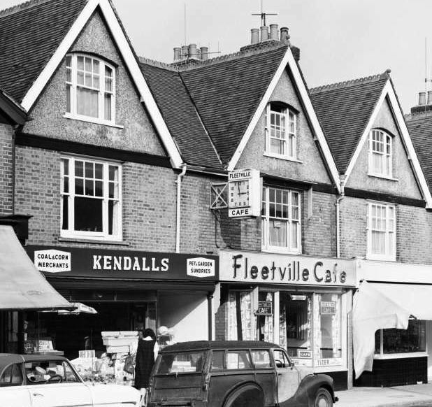
Hatfield Road c1914.  Smith's printing works on the left; Bycullah Terrace shops on the right.
Arrowed is the vacant land just beyond the shops and where Russell Edwards chose to
assemble his cinematograph building, a former chapel or parish hall.
There arrived on the scene several cart loads of metal, timber and panels of corrugated iron.  They had been brought from the Midland (now City) Station where their rail journey from Colne in Lancashire (or Colne Valley, Yorkshire) had begun.  Local people had become used to quirky buildings and Meccano-type temporary structures before.  Tin churches were quite common. But what was this one? Difficult to work it out from the piles of assorted stuff on one corner of the site, although it apparently wasn't certain whether the stacks were fully on the correct site or partly overflowing onto the adjacent plot, which Edwards also chose to use without the owner's permission.

During the next few weeks a variable number of casual workmen turned up each day to assemble what today would be called a pre-used building.  In fact it wasn't even second-hand, but third-hand, and it appears that several assorted parts were missing.  The structure's last use was as a chapel or parish hall, so is that what the people of Fleetville were going to get?  If the workmen can be persuaded to remain at work – many had not been paid for some time –  the word on the street was they were being promised a cinematograph building.

This would have been the view of the building from Hatfield Road.  The projector box, far 
left, was thought not to have been part of the acquired kit and would have been added on
site, if there had been space without incursion on to the neighbouring plot. Tess Road
(now Woodstock Road south) is on the immediate right.
COURTESY HERTFORDSHIRE ARCHIVES & LOCAL STUDIES
The Council was offered a set of plans, as shown in the images below, and proposals for a building which the Council may not have been aware was already in build.  Unfortunately, the Council turned down the plans, because as Russell Edwards had been enterprisingly concocting his Fleetville project a new safety law, the Cinemas Act, was added to the statute books.  This specified how cinematograph buildings should be built, what facilities they should comprise and the standard of those facilities.  The new Fleeville cinematograph, it turns out, did not comply and was not likely to have been the comfortable exhibition building customers might have expected. 

The proposed plan for seating (green) supposedly for up to 450 customers.  There appears not to
be a specific place for payment to be made, although many early buildings ran on the fairground
principle with moneys collected outside.  Electricity had only arrived in St Albans in 1908 and it
would be some while before Fleetville would benefit.  The Engine Shed would have housed
a generator.
COURTESY HERTFORDSHIRE ARCHIVES & LOCAL STUDIES

COURTESY HERTFORDSHIRE ARCHIVES & LOCAL STUDIES

There were other issues too.  One of Edwards' investors was lied to about the details of the project and suffered other financial problems. The purchased building was also too large for the plot, and instead of modifying the structure to fit, he instructed his workmen to "borrow" a part of the next plot, which unfortunately had not been fenced off.

There is no doubt, it was a basic building on a flat floor – even though the elevation drawing shows a sloped floor – and would not have been appropriate for use in winter.  There was one male urinal and no evidence of toilet facilities for female customers.  A tiny porch opened out onto the footpath of Hatfield Road.  If you were to visit the Post Office today, including the vet's premises next door, and then walk round the corner to the rear of the Post Office plot, that is where the promised 450 cinematograph viewers would have supposedly been accommodated on their chairs.  

The building never opened to the public; wasn't even finished. Edwards was taken to court for various financial irregularities and non-payments to creditors or his workmen.  Edwards was imprisoned, but meanwhile the court sitting required the building to be demolished, the component parts and the land sold to reimburse creditors.  So Fleetville residents never got to be entertained here.

Although the opportunity was very brief, did anyone grab a camera and record any part of the construction, particularly the nearest it reached to completion?  Or maybe even the workmen who were not paid but had to return home to their families to put meals on their tables.  Fortunately, we do have access to the plans and elevations, which are shown here, but unlike artists painting what is in front of them, can we be sure there were drawings of the original structure when it was in use at Colne?  Did W H G Hubbard, architect, make his drawings from measurements, from the building's original site, or from a company sales catalogue?

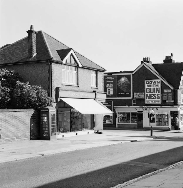
The cinematograph site remained cleared for sixteen years before the current building was
erected in 1930 for A Rankin Smith.

A photograph demonstrating how the building appeared in its street setting would be a rare example of any building work actually in progress in this new suburb, but such activity did not, it appears, excite anyone who owned a camera.  Following the cinematograph's  demolition it would be another sixteen years before another building would be brought to this corner plot; the store and post office of A Rankin Smith.

At this period just before the First World War there was an increase in the number of people who had taken an interest in photography, using their skills to sell copies of their negatives to the locals, or as artistic views of street scenes at events across a wider geographical landscape.  Perhaps, even during such a short construction period, one photographic image might have been taken.  But does it still exist?

Link to Fleetville Cinema on SAOEE website.

Link to blog post "Missed the Flicks": https://stalbansowneastend.blogspot.com/2020/09/missed-flicks.html


Sunday, 12 June 2022

The Rec in 1946

 Just when you think you know a place well, along comes a fresh element about which you had no previous knowledge.  Or almost no knowledge; but more of that shortly.

The map below covers the same area as this 1946 aerial photograph taken by the RAF.  
Hatfield Road crosses the bottom of the picture. Fleetville Recreation Ground (Fleetville
Park is left centre with Fleetville School to its right.  In the top section roughly west to east is
Burnham Road and lower Brampton Road.
COURTESY HISTORIC ENGLAND

In the previous post you will be aware of a series of RAF aerial photographs taken in 1946 and now available to view on the Historic England website.  In that post we explored The Park.  This week I've chosen to home in on part of the very heart of Fleetville: the Recreation Ground, Fleetville Infants School, and Royal, Woodstock, Burnham and Hatfield roads.  The aim is to contrast today's  topography with that of 1946.  In so doing we have to manage an image of high contrast created by the bright sunshine and deep long shadows on the day of the flyover.

The map covers the same area as the aerial photo.
COURTESY OPEN STREET MAP CONTRIBUTORS


The very recognisable range of pitched roofs of Fleetville School, which were two distinct buildings in 1946, with a playground space between the junior and infant departments, is now, one joined structure and also enlarged at the northern end (the old Boys entrance of elementary school days).  The wooden Hut, consisting of two classrooms, arrived in 1938 is now replaced by a large modern hall on the Woodstock Road South side, and the long narrow structure further north along the same boundary were the outside toilets.  Although these have now gone the high boundary wall still exists as a kicking wall.  The space south of the former Hut consisted of a garden for the adjacent police station and house (shown as car park P on the map) just behind the Post Office.

Fleetville School (Infant School today) with the wall on the right.  Behind this was once the outside toilets.

Turning our attention to the Recreation Ground (Fleetville Park on the map), a temporary building had been constructed just behind Royal Road in 1942.  It was a day nursery for the young children of employees at the munitions works in Hatfield Road (Fleetville Community Centre and Morrisons on the map). The bright fresh concrete slab on which the building was placed shone out in 1946. Just visible on the Royal Road side of the building was where the embankment down to road level had been partly cut away with a concrete ramp leading down to underground tunnel shelters; the building had been placed on top of the tunnels cut in 1938 and 1939. The ramps have now been levelled to create the present car park in front of the community centre.

The rear elevation of the Community Centre


Wartime street shelters constructed in the roadway.  This example is from Manchester.
COURTESY MANCHESTER LIBRARIES


This leads us to a recollection given to me a few years ago; a resident recalled when he was a child that "a few" street shelters were constructed in the roadway of Royal Road.  I searched in vain for confirmation but found none – until now, for the RAF photo taken in October 1946 clearly shows six structures on the footpath and half of the roadway outside the nursery building.  They must have been demolished and removed in 1948 for I do not remember them.

Residents wishing to see the (temporary) community centre building will need to be quick; it is expected the building will be demolished in July of this year, in preparation for a new building to go up in its place.

An emergency water tank similar to, but much smaller than the one, on Fleetville Recreation
Ground.  This example is from Aston, Birmingham.
COURTESY BIRMINGHAM CITY ARCHIVES

The rectangular structure near the Hatfield Road boundary was an emergency water storage tank for the National Fire Service, clearly emptied for safety, next to which was the ARP hut.  Here is this week's question: halfway along the diagonal footpath between Hatfield Road and Royal Road is a circular shape.  Although I can identify the children's swings to the right of it, was there a revolving ride, such as a roundabout or witches' hat?  I remember neither of those, only the swings.  Anyone with further information please contact. 

On the south side of Hatfield Road, far from straight, near the southern edge of the photo are the long parallel roofs of the former Fleet Works, the Smith's Printing factory, by 1946 being used as Ballito hosiery mill.  Immediately to its left is a narrow grey-looking site with seasoning sheds to the left, which today is part of the surface parking for Morrison's.  But in 1946 was a busy timber yard owned by the Lavers family.  Recognisable by its shape is the outline of the former Central School, now Fleetville Junior School, today little altered from its original form.

The timber yard of W H Lavers, Hatfield Road, now under the car park of Wm Morrison's 
supermarket.  The site was a busy one both for building companies, general contractors and
homeowners.
COURTESY ST ALBANS MUSEUMS


The north-south road to the west of the Recreation Ground is Harlesden Road, one of the many
parallel roads which helped to swell the population of Fleetville from the early 20th
century.  This is Harlesden Road, from the Hatfield Road end, taken around 1914.
COURTESY ST ALBANS MUSEUMS


Many photos of Bycullah Terrace are taken from the western end.  So, just for a change
here is a picture taken from the Sutton Road corner about ten years ago.

Back on the north side of Hatfield Road is the eastern end of the Slade building estate of the early 20th century; the compact terraces and semis of Harlesden, Burnham, Brampton and Woodstock roads, and the two long terraces of Arthur Road.  It is disappointing the deep shadows cast by the Ballito factory hide all of the detail of the most interesting section of Hatfield Road at Bycullah Terrace – Fleetville Shops. 

If you live, or your family lived, anywhere on this photo you will pick it out immediately.  Fleetville was, and still is, a busy suburb of the city.  Until the previous year, 1945, it still hummed with the young voices of children who had become honorary guests of St Albans, having been evacuated here from London boroughs and the Sussex coast.  Let's remind ourselves: this was seventy four years ago.

Friday, 18 March 2022

Post-war Primaries

 The County Architects' Department produced the perfect solution, under the circumstances, for the post-war period.  It developed designs for schools of all kinds, based on a modular system with seemingly endless variations on a theme.  The system was great for the time, although not every efficient in today's world. In every part of the county we can spy plentiful examples of schools having an  intended design life of around thirty years still coping well more than twice as long.

One of the first of our post-war primaries, Windermere (1957), located on the northern boundary of
London Road estate.
COURTESY DIANA DEVEREUX

The demand for these modular buildings was significant.  A number of issues combined in the post-war years to strain, almost to breaking point, the budgets of a county department attempting to provide sufficient school places.  Firstly, the pre-war elementary conversion was not complete, and of course, little or no maintenance was  possible during the wartime period. The number of households had grown, though not the number of homes; the number of births grew during the course of the war, and a further increase during the early post-war years.  The authority was forced to plan for significant numbers of new places, without the benefit of a recent national census since 1931, and there was now a requirement for primary schools to be located within an easy walk from children's homes.

Camp School, saved by the size of the new post-war estate behind it and the numbers of young
families living nearby. 

The infants building was the first to arrive in Cell Barnes Lane; the junior school arriving a few years later.
COURTESY CUNNINGHAM JUNIOR SCHOOL

It is easier, with the post-war primary phase, to focus on three distinct east end communities: Camp, Fleetville and Marshalswick.  Camp School had opened in 1898, the first to be located in the expanded areas of St Albans since 1879.  By 1939 it was considered that Camp School had "had its day".  It was full, but it lacked modern facilities; in fact, it even lacked some of the most basic facilities.  Future estates were on the drawing board – and with them sites for new schools.  So the new schools would be built first and only then would Camp School be closed and demolished.  With a prompt start on house building of the early London Road estate, a rather inadequate opening up of the extremely narrow Windermere Avenue cul-de-sac meant that clusters of new homes were built nearby, on allotment land. It was inevitable that the first new estate school would be Windermere JMI (1957).  In Cell Barnes Lane, extending the former Springfield estate into the hub containing shops, flats and meeting places, was built Cunningham Infants School.  Ideally, the authority would have liked to confirm a future junior department too, but this was not possible until more land had been purchased.  Modern estates were required to include more public open space and land for any further school was unlikely to be found.  The Council bowed to the inevitable and retained Camp School, adding new facilities where possible.  And today, in 2022, Camp School remains a flourishing learning environment.

The 1913 original infants building at Fleetville.  From about 1948 the buildings, including the huts
and nearby nursery were overcrowded.


An example of a HORSA hut (Huts fOr the Raising of School Age).  Beaumont Schools had
three of them, paving the way for the secondary leaving age rising to 15.  The formative
Oakwood School used two classrooms in on of them for two years.

Oakwood JMI today.
COURTESY GOOGLE EARTH

Turning to Fleetville district, where the school was transformed from elementary to primary over a period of time, the peace years began  with two forms of entry in both infants and juniors, and in the mid fifties junior classes reached fifty or more children,  Use was made of  a classroom in the Royal Road nursery building as well as small groups in the former police station in Woodstock Road South. Plans were even made for an emergency conversion of at least one house in Burnham Road.  An active parents' association exerted pressure to reduce class sizes by opening a new school, and was disappointed not to have been given the larger buildings of the nearby Central school on two separate occasions in the 1950s, only succeeding in 1975.  Remembering that the authority had purchased land in Oakwood Drive during the 1930s, specifically for a future primary school, it put in place its "Fleetville Extension School".  Part of it was open in 1957 for infants (shortage of funds again), and temporarily two junior classes were provided with one of the HORSA (Huts fOr the Raising of School Age) buildings on nearby Beaumont's grounds.  Given its location the new school was, inevitably, named Oakwood.  Its catchment, however, has remained extensive, including Oaklands and parts of Sandpit Lane, in addition to an increasing number of infill homes in the district.

Skyswood JMI today.
COURTESY GOOGLE EARTH


The Wheatfields schools today.
COURTESY GOOGLE EARTH


An open air event at St John Fisher JMI.
COURTESY ST ALBANS LIFE


Apart from old Marshalswick, the new housing, which came to be known as the Nash estate from 1938 onwards, also included a considerable number of new homes in the 1950s.  But there were no local school places available nearby until 1960 when Skyswood JMI (Chandlers Road) opened. Until then children of primary age were allocated places at Sandridge School and Spencer Junior School, or Fleetville School – we've already explored its crowding issue above!  But one primary would never be enough for a large estate, and so Wheatfields School in Downes Road entered the building programme and opened in 1963.  As had occurred elsewhere, whenever more than two such schools were planned negotiations took place with voluntary organisations, usually churches.  The third Marshalswick primary therefore became St John Fisher JMI in Hazelmore Road, very close to Skyswood School.  

Samuel Ryder Academy all-through 4 to 19
COURTESY TG escapes

The greatest demand for primary places at large estates usually comes with the first flush of new families moving in.  After a while numbers of school age children stabilises and a variable number of spare places continues to be available.  So, when Jersey Farm was developed in the 1970s the decision was made not to include a school, as long as there were road and footpath connections to the existing The Ridgeway where all three Marshalswick schools, as well as the secondary school, were accessed from.  The same decision was made in the 1990s when Highfield Park residential development began; no primary school was included.  In this instance, however, the existing primary schools at Camp (Cunningham, Windermere and Camp) would be unable to offer sufficient numbers of new places.  Therefore, in the upgrades proposed for the secondary school which became Samuel Ryder Academy, a primary phase was included to make SRA an all-through school; pupils from age 4 to 19 on a single site.


Sunday, 9 January 2022

Measuring the Electronic World

Tech industries were thriving during the 20th century's first quarter, and Guglielmo Marconi was ahead of the game when in 1896 he brought to the world the concept of wireless telegraphy.  He delivered and set up the first Marconi Wireless Telegraph and Signal Company in Chelmsford the following year.  

St Albans folk are, of course familiar with the name Marconi as one of its companies was a major employer here, but we are perhaps short on the detail as the company was associated with several sites.  So, we will explore exactly where in our East End and elsewhere, the Marconi name came to rest.

Result of the blaze which destroyed the Hill End Brick Works in December 1928.
COURTESY HERTS ADVERTISER


The first homes to be advertised in Longacres in 1937.


Making way for new buildings at Longacres HQ by inventive manoeuvring of the portable canteen building to its new location on the site.
MARCONI STAFF JOURNAL VOLUME 1    

The completed Longacres HQ buildings on the former brickworks site.
COURTESY MARCONI HERITAGE GROUP


An early commercial connection Marconi made was not in St Albans at all, but in Southend.  This was the home of E K Cole, the sole manufacturers of electronic testing instruments in the UK. Many of us may remember their radios under the EKCO brand name.  As electronic equipment became more sophisticated the need for more complex testing instruments proved increasingly essential.  In 1936 the two firms joined forces, but in 1939 the E K Cole/Marconi team were moved, on government instruction, away from Southend's potential enemy danger to a temporary works site in High Wycombe.  A short time later the two teams became one as Marconi purchased Cole shares and a new company formed as Marconi Instruments Limited (MI).

Manager's Secretary Hilda Wallace who was featured
in the staff journal's first edition in 1951.

This is where St Albans enters the story – well almost.  A young song and dance lady by the name of Hilda Wallace – ex Cook's Tours – joined the formative MI as the Manager's Secretary, working from a small house in Radlett.  Whether this cottage was also Hilda's home I'm not certain. Remember, this was wartime and business space was where it was available, not where you would like it to be.

Within a short period space was found in part of a large house in Hatfield Road, St Albans, called Elmhurst, later simply number 29.  This building will be familiar to many citizens as it became the formative home of St Albans College of Further Education – before all the 1959 new buildings went up.  Hilda led a small team of Marconi typists from here and it is from this point that the very necessary company departmentalising was formulated to develop efficiency over multiple sites.

Former straw hat factory featured in a Heather & Heather promotional brochure. Here looking
rather more attractive than the actual building shortly after WW2.

The manufacture of electronic instruments and equipment required the availability of a huge variety of components in ever-increasing quantities and sourced from all over the UK.  But a number were made from scratch at a building in Ridgmont Road.  Not one of the sizeable villas which fill both sides of that road, but the very much  larger former straw hat manufactory which many commuters would have remembered as Heath & Heather (H&H), the herb specialists, whose four-storey building stood next to the Midland railway line by the the City Station.

The work of H&H had been downsized or squeezed into smaller spaces, and Marconi assemblers were installed wherever space could be found. And storage space was required for a large range of components prior to shipping to the High Wycombe works.

Back at the end of 1928 a serious fire had resulted in the closure of the Hill End brick works between Hatfield Road and Hill End Lane (Station Road).  [see top photo] The site remained desolate and unused for some time.  Nearby, housebuilding had begun nearby in 1936 to provide residential accommodation in a new road named Longacres. Work was undertaken in 1939 to clear and level the brickworks site next door and temporary buildings were brought in to become the company's warehouse.  There is no connection between the 1936 Longacres housing development and the Marconi Instruments factory site adjacent to that road, other than the street name.

Day-to-day operation of the company was hardly efficient under such dispersed war-time arrangements, as Miss Wallace discovered; therefore no sooner had the Longacres' residents' 1945 street party taken place than two years of building and moving began on the brickworks site to add the first generation of works buildings to the existing stores.  The entire company of Marconi Instruments Ltd came under one set of roofs for the first time in mid 1947.

Work stations at the Hedley Road service department.
MARCONI STAFF JOURNAL VOLUME 8

Except, that the one roof concept was short lived for a company whose reputation and size kept expanding. The next site which came into the frame; behind Beaumont Works, which was the Nicholson coat factory, was a single storey brick building with its own former basement air raid shelter and ready for new occupants.  MI opened its service department here.  It was quite a complex operation, where equipment arrived for repairs, replacement of parts and investigations about reliability.  The department was undoubtedly hugely significant, as its proved the baseline for all departments. The experience garnered here fed back to improve designs, increase standards and create modifications leading to new models at the main works at Longacres.

Left: part of the Ballito building originally built by T E Smith's Fleet Printing Works.  Right:
the post war expansion building of Ballito and subsequently taken over by Marconi Instruments.
COURTESY MARCONI HERITAGE GROUP

Probably the first of the company's post-war advertising in 1945, and too early to add
the name Longacres to the street address.
    COURTESY GRACIES GUIDE

We're not finished yet, because Fleetville featured more than just Hedley Road.  Even during the dispersed period of wartime the embryonic MI was using space at the large Ballito factory, which itself had turned over to shell casing manufacture.  Later, the post-war Ballito multi-floor block built for new ranges of woollen wear and nylon products, was partly, and then entirely used for MI components and assembly.  Finally, when Courtaulds acquired ownership of the main Ballito mill by acquisition, the site, but  was promptly sold again to MI.

While 1970 was the high-point of MI's occupation of buildings in St Albans' Own East End, the company continued to run a successful business.  There is, of course much more to the MI story, but the only part which remains to be included here, is a mention of prefabs brought to Hill End Lane and St Julians for key workers from the High Wycombe works, who for a few years had commuted to St Albans by special coaches laid on each day. As  building licenses became available a number of permanent homes in Charmouth Road and other locations were made available for a number of MI key employees.

Probably the most well known of the company's buildings, Marconi House on the corner of The Strand and Aldwych, has not been further mentioned, along with buildings in Stevenage, Colchester and Chelmsford.  They might make a blog on another occasion.

Finally, there may be a number of former MI employees who are able to fill in gaps in the firm's location story – for example, whereabouts in High Wycombe were the two entities sent at the beginning of hostilities?  Or perhaps that is still a state secret!

Friday, 26 February 2021

Cycling and Walking in Fleetville

 Fleetville has always been subject to suggested changes; you might say there have been plenty of ideas, although most have bitten the dust before seeing the light of day.  There was to be the new road between Sandfield Road and Camp Road, which got as far as Roland Street/Campfield Road because someone else paid for it.  There was the roundabout to replace the first one at the Crown junction; that became the 'teccy' traffic lights (and not before time).  Once The Quadrant had opened in 1959, there was a suggestion to replicate the idea somewhere along Hatfield Road and take more of the shoppers' parking off the main road;  I don't think they had Morrison's in mind.  Oh, and there was a proposal for an underground car park at the Rec – yes, where and how would they have sent the sub-soil? By road of course.

Hatfield Road walking and cycling anywhere you want in 1906.

The main road has been widened in places, but we still have to breathe in as we descend the narrow hill towards The Crown.

We may have benefitted from the building of the St Albans' bypass in the 1920s, but we could have done with another rethink in the 1960s.  In fact, with the closure of the branch railway line someone thought it would be great to send traffic between Holywell Hill, London Road and Hatfield Road at Colney Heath Lane.  No, that didn't get anywhere; neither did the plan to extend the Abbey Line onto the "Alban Way" route to Hatfield and Welwyn Garden City.

A car-less Blandford Road in 1907
Courtesy HALS

As the number of cars per household increased passing through the parallel roads became more challenging, not least for residents, but also for drivers trying to pass each other having met in the middle from each end.  The one-way concept did not meet with majority approval, and zoning is the latest idea for parking, but of course that has put pressure on roads just outside the zone.

Tunnel parking in Sandfield Road
Courtesy Google Earth

The new proposal up for discussion is a Low Traffic Neighbourhood. LTNs attempt to address several deficiencies in the current road network.  First of all it tries to ensure those who live in the LTN are able to move around within their patch with greater ease.  Keeping rat-running to a minimum so that drivers who nave no need to be in or pass through the zone are dissuaded, and vehicles which need to be there a maximum speed is reduced to 20mph. By these three measures cleaner air near people's homes should be possible.

But there is a second range of possibilities through reducing the number of vehicle movements and speeds;  the zone has pavements which are narrow and close parking head to tail is inevitable. Visibility for pedestrians can be limiting and is no better for cyclists.  With shops close by it is hoped that cycling and walking can become the default methods of travel.

The proposed Low Traffic Neighbourhood bounded by Hatfield Road, Beechwood Avenue, Sandpit Lane and the Midland Railway
Courtesy Hertfordshire County Council

The county council would be designing the scheme if it proceeds, and that would include signs and alterations to improve visibility at junctions.  But no doubt other arrangements would be considered.  Unfortunately, its website does not show what has been achieved in other places where LTNs have been introduced.  Without such examples it is difficult for us to imagine and comment meaningfully what a Low Traffic Neighbourhood might impact on the lives of Fleetville residents, whether we live inside or beyond the boundaries of the zone.

Residents have until 16th March to make their comments.  The website is www.hertfordshire.gov.uk/activetravelfund.  Responses can be made directly from the website.

Saturday, 10 October 2020

Bycullah

 Let's begin with the name of the row of shops which is west of Arthur Road.  When the printing works arrived in 1897 we would have been looking towards the north of Hatfield Road and to a field extending from Andrews greengrocery to the access road, now the new Montague Close.  Print firm owner Thomas Smith had these properties built, and named the row Bycullah Terrace.  His home was a very large house called Bycullah House in Bycullah Road on the wealthy west side of Enfield.

The terrace c1908 with the grocer on the left corner of Tess Road, now Woodstock Road South.
In the distance only one house, now replaced by the blue flats, had so far been built on the south side, east of Sutton Road.

The same view c2000. The road has been moved slightly south to allow space for parking
outside the shops.

On weekdays the parade would be busy in the early morning and early evening with employee
arrivals and departures at the printing works; and workers or managers visiting the Dining Rooms
or the Institute (right) during the midday break.
COURTESY DAVID MILES

The terrace as built consisted of three houses, intended for managers of the print works, set in the centre of the terrace, and three shops on each side of these homes.  They were to serve the "Ville" of homes being built in the rest of the field.  As occurred elsewhere in the Ville many of Smith's houses were let to non-employees.

Only one impediment obstructed the buildings, a milestone for the toll road, but the buildings were arranged to sit immediately behind the object (see my blog "A Mile is Not a Mile" 1st February 2020, because the milestone is certainly not in front of any of the shops today).

In 1964 the area is busy enough to require a pedestrian crossing, which was set out for the
Ballito works and the Central and Fleetville Schools.  Today the area is crowded enough for a second crossing in Woodstock Road South.
COURTESY ST ALBANS MUSEUMS

The three houses in the centre of the block remained residential until 1930, although there were short periods when unoccupied, the house which is now the optician began as Fleetville's first physician and surgeon, William Graves.  A year before the arrival of Dr Frederick Smythe at Fleet House (see last week's post), he  practiced at Bycullah Terrace.  Next door was Joseph Hassall, superintendent of the County police, responsible for the police station in Tess Road, also as referred to in last week's post, although the house remained unoccupied most of the time before 1911.  The third house remained completely domestic until  the mid 1950s, and the ground floor wasn't fitted out as a proper shop front until after 1960.  It was Kendall's Coal Merchant, and the author recalls entering through the street door and paying the family fuel bill in the front parlour.

This picture was taken a few years after the house was converted into a shop for Kendall's.
COURTESY STEVE KENDALL

Percy Hall's hair salon to the left of the first house, which would later be converted for Kendall's.
COURTSEY JACKIE ALDRIDGE

The first two houses had an earlier conversion shortly after 1930.  A H Smith opened a bakery; this later became A & E Spurrier, who was also a baker, then ABC Sandwiches, before the current optical services.  In the middle house Mr Dellar tried running a Wallpaper shop for a short time.  It was also Percy Hall's hairdressing salon before he moved along the road, but for the majority of its life it has been a grocer: Pollard's, Green's, Key, and Saar Convenience Store, today using a vinyl on the front window to replace an actual window display, as is the modern trend.

If the shops were intended for the Ville residents it will be interesting to discover the extent to which they were for everyday requirements, and whether the same applies today.  Of the western group of three, the corner establishment remained a grocer for a full century: Charles Philips, Frank Lovegrove, Leslie Bennington and Dixon's.  It is only in recent years that it has offered cultural foods.

Mrs Blakeley and her father outside her shop which generations of children identified as the "sweet shop"
COURTESY CHRIS WARD

Next door a general shop, which would be known as a confectioner – children would know it as a sweet shop and their parents would purchase their tobacco products.  P H Stone, who started at Primrose Cottage shop, where the Rats' Castle PH is today, moved there and then transferred to 157 Hatfield Road.  Mrs Blakeley arrived in the mid-1920s.  William Grace, a manager from de Havilland Aircraft Company, retired from that role in 1946 and took on a quieter role running the shop. Around 1970 it became a dry cleaners and now, with the internal walls removed it is Alban Locksmiths.  Retained is the step between the former front and rear rooms, as the the left shops were built on a small hill (as seen in Woodstock Road South).

The third shop began as William Helmsley's stationer, drapery and the little district's post office, before being taken over by John Smith, of the same family who moved to new premises as Rankin Smith c1930, since when the Warwick family ran the shop as Fleetville Fisheries, with an open front and roll-down shutter.  Today the shop is one of the many shops owned by Simmons, the bakers.

A 1964 photo showing Kendall's as a fully converted shop, and the Fleetville Cafe, tables in the windows and a corner counter on the left. Many residents would have recalled the clock above the
shop which often only showed the correct time twice each day!
COURTESY ST ALBANS MUSEUMS

The first of the three eastern shops has always been the local cafe (in earlier times known as Dining Rooms).  It is only from c2016 that it became Fleetville Fish Bar and then Nonna's Pizza.  The middle shop of this group (217) spent the first five years or so as an ironmongery, and was then the parade's butcher, in the care of two families: James Finch and then Horace Presence. Now it is a barber's.


On the Arthur Road corner during the occupancy of the
chemist run by H Bowman.

Finally, on the Arthur Road corner, this shop had three separate lives; first as a greengrocer, then a bookmaker and repairer, and finally H Bowman, the chemist, in roughly equal measure.  Intended for part of the leisure trade in modern times anglers are now served.

Most residents today consider Fleetville to be a significantly larger area than when the Smith Ville was developed.  But it is generally accepted that Bycullah Terrace and its environ is the true heart of Fleetville, partly because it was Thomas Smith who named it so, and this is where the first bricks were laid.

Although there are nine roof elements, one for each property,  two of the three houses share a single wide canopy, with a smaller decorated brick elevation fitted with triple casements each.  This is best viewed from the opposite side of the road.
COURTESY GOOGLE STREETVIEW


Wednesday, 30 September 2020

Missed the Flicks

 Not only were there no houses on what later became the recreation ground, but there were few homes built on the T E Smith land  between Royal Road and Tess Road (now Woodstock Road south) either.  A row of  six small homes appeared in Royal Road, and one detached and two adjacent semi-detached houses on the west side of Tess Road.

1922 OS map showing the school and (circled in blue)
the police station and police houses.

1922 OS map showing the Hatfield Road block outlined in red.
MAPS ABOVE COURTESY NATIONAL LIBRARY OF SCOTLAND

This was the point, in 1906, when the County authority concluded it needed to take decisive action in providing services for this extensive series of private residential estates, and with more to come; open spaces, education facilities and the Police Constabulary were definitely not part of the brief of house builders.  The County moved its police station into the first house in Tess Road with the Sergeant and Constable living next door.   In the 1970s all three buildings were demolished to provide land for parking and a children's nursery.  The largest land acquisition came to provide – at last – land for an elementary school; this came following pressure from countless parents who had to send their children "over to the Camp School".

Royal Road to the left; Woodstock Road (Tess Road) to the right. The little car park and the
building beyond are the site of the former police station and police houses.
The 1922 OS maps (top images) show a broad band of vacant land adjacent to Hatfield Road, and it remained in that state until c1930 when another service lacking in Fleetville was finally provided: more adequate medical support.  While there was a doctor and a dentist at The Crown end, it was not until shortly after 1930 when Dr Smythe built a detached house and surgery at the corner of Royal Road.  It still sports the original name of Fleet House, and it was distinctive in possessing a corner front garden.  Although it sits snugly into the Hatfield Road streetscape it actually belongs to Royal Road. Fleet House was later converted into a pair of flats and the original rear garden plot was then used for a small detached house, 2B Royal Road.

Fleet House to the left and the parade beyond in 1964.
COURTESY ST ALBANS MUSEUMS

Post-conversion view of Fleet House with added access to ground floor flat.

However, Dr Smythe was beaten into second place by the arrival of John Smith, stationer and draper who previously ran the third shop in Bycullah Terrace, which also had a corner devoted to a Post Office.   It had been a busy shop and Mr Smith sought more space for his trading. Purchasing the corner plot at Tess Road he engaged the building partnership of Goodwin & Hart to create what everyone still knows as the Fleetville Post Office.  The original garden plot faced Hatfield Road, but an extension to the Post Office and drapery was constructed on the garden c1960.  This is now the separate business of MediVet. 

The Post Office still with its rear garden and name fascia A Rankin Smith in 1964.
COURTESY ST ALBANS MUSEUMS

The shops c1960.  The extension being constructed in the garden of The Post Office.
COURTESY JACKIE ALDRIDGE

The trend in the 1930s for a single building combining several shops, and also identified in a recent post, was continued here where three standard width units and a pair of half-sized units were built.  First to open was Percy Hall's hairdresser departments for both women and men.  Mr Hall had previously opened his first salon nearby in Bycullah Terrace and had others around Fleetville at different times.

Recent view of the shop which began as Harpers Motors and later St Albans' Scooters.

When Norman Harper first opened his Motor Sales showroom as late as 1939 the legal documents reveal this block of land had still been in the ownership of the estate of Thomas E Smith from the former printing works opposite.  Although now a phone repair shop the street elevation still has the original bracket arm for frontage lighting; street lighting in the 1930s was still quite poor.

The two half shops began as London Central Meats and a studio photographer.  After the Second War they were Baxter's Butchers and Garrard Fruiterers; and along the sideway to the right was a signwriter's business for S T Broad.

The Post Office with shops beyond.  This is where building activity took place in 1912 to create
Fleetville's cinema. This is the orange block outlined on the second map above, and occupied
a wider plot than had been paid for, according to the court report in the Herts Advertiser.
COURTESY GOOGLE STREETVIEW

A plan and front (Hatfield Road) elevation drawing of the cinema.  Not a single showing
took place, and no sooner was the building up than, by court order, it was taken down.
COURTESY HERTFORDSHIRE ARCHIVES & LOCAL STUDIES

So, where do the flicks come in?  Well, the building came – and went – so quickly that not a single performance took place. Russell Edwards living in Granville Road claimed to be a showman, and saw a business opportunity which wasn't entirely legal and put up a secondhand tin building as a picture house/cinema.  Without using his own funds this serial mischief maker assured an investor that the cinema was already open and operating profitably and attracting patrons in numbers which, in fact, could not possibly have been accommodated.  In fact it was just a pile of tin and iron lying on the ground and the men engaged to erect it were sometimes not paid.  Creditors caused Edwards to be taken to court – again, and the court ordered that the building, so close to opening, should be taken apart and sold to defray court costs.  When did this occur? In 1912, so becoming the first occupier of this block. And where was it?  It all happened on the plot which is still Fleetville Post Office today.  

Sorry you missed the show!

Next time we'll trace the story of the most well known Hatfield Road trading quarter, Bycullah Terrace, and discover the origin of its name.