Showing posts with label Jennings Road. Show all posts

Thursday, 14 October 2021

Clarence Conservation

The previous post highlighted the details of Sleapshyde's Conservation Area and Character Statement, which is one of only three in the eastern districts out of 27 within the St Albans District.

The Midland railway marks the western boundary of the Clarence
Road Conservation Area and Clarence Road winds its way north-
south on the eastern side.  The houses which are coloured green
are locally listed.
COURTESY ST ALBANS DISTRICT COUNCIL


Today I am turning my attention to the Clarence Park Conservation Area (CA) and Character Statement (CS).  The zone is bounded by the Midland Railway, Hatfield Road, the rear of properties on the eastern side of Clarence Road (both lower and upper), and Sandpit Lane.  Many of us enjoy spending time in Clarence Park itself and we will often catch glimpses of houses which line Clarence and York roads, though we may be less familiar with Blenheim Road, upper Jennings Road and Gainsborough Avenue – although the latter contains no locally listed houses to form part of the collection.  Finally, there are four identified structures within Clarence Park, although one of these, Verdi's restaurant, is technically not within the park, a point I will briefly return to later.

The 1897 OS map shows the recently laid-out Clarence Park together with lower Clarence Road
prepared as far as what will shortly become York Road along the line of the footpath (FP).
At this point no work has begun on the Spencer estate, nor Brampton Road.
COURTESY NATIONAL LIBRARY OF SCOTLAND

The Statement briefly confirms the area's history as land belonging to St Peter's Farm which had been owned by William Cotton (who was not referred to) before being partly taken for railway construction and the remainder acquired by Earl Spencer.  The park was formed from two tranches of land: the former fete field, which became the pleasure park and is the area adjacent to Hatfield Road; and the section purchased by Sir John Blundell Maple specifically for a cricket field and other active pursuits.  Only the latter is referred to in the CS, but the fete field was used by members of the public long before the formation of the park in 1894.  Lower Clarence Road and York Road were adapted road layouts which, together with the railway and Hatfield Road, were intended to envelope the park.  Earl Spencer added to this his residential estate reaching Sandpit Lane, the western part of which lies in the northern part of the CA.

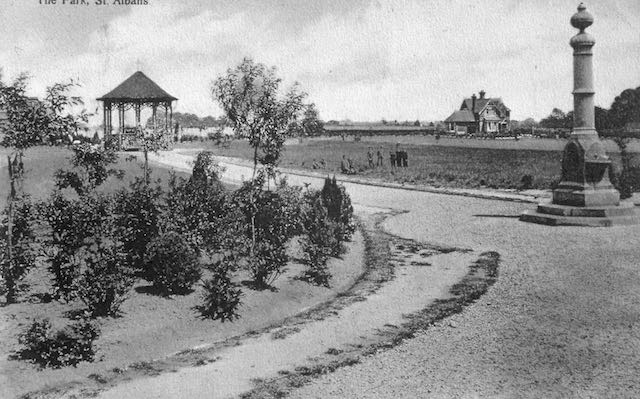
The freshly laid-out pleasure park, the former fete field, with the drinking fountain donated by
Lady Maple, the first bandstand, and, in the background is shown the park keeper's lodge.
COURTESY ST ALBANS LIBRARIES (HALS)


The cricket pavilion and changing rooms.

Probably the main reason the park remains within this CA is its largely unaltered layout.  It is heralded as an untouched Edwardian open space with the lodge and cricket pavilion both recognised in the CA as original features; also the later-added pay kiosks and earliest football club rooms, the water fountain donated by Lady Maple which was installed soon after the park's opening; all are identified as locally listed.

The only structure which does not fall into the above categories is the building, formerly public toilets for The Crown local area, used today as Verdi's restaurant.  This is no longer in the park as the boundary fence was moved northwards in 1928 to provide extra visibility to avoid a potentially dangerous blind spot for vehicles emerging from Clarence Road. A short time later public toilets were built in this space which reduced some of the visibility earlier gained!

A group of the houses overlooking the park at the Hatfield Road end of lower Clarence Road.

Numbers 4 to 30 Clarence Road, as well as Alexandra House, are the first group to be locally Listed and the cottages fortunately have unaltered frontages. Alexandra House is the former Barclay's Bank and chemist shop when first opened.

Two pairs of large semi-detached villas just north of the park entrance in lower Clarence Road.

Many of the remaining semi-detached houses in lower Clarence Road and overlooking the park are described as Queen Anne/Domestic Revival style.  They are substantial and so similar but not identical, which prompts the question of their design.  The CS suggests there were at least three architects at work here: Percival Cherry Blow, Henry Hansell and Henry Mence, but others may have also been part of the practices.

An arts-and-crafts style house in upper Clarence Road.
COURTESY GOOGLE STREET VIEW

Most of the homes in upper Clarence Road are all on the list even though they were built in a variety of styles. Newer infill properties have been excluded.  However an arts and crafts corner house with a lych gate and well-protected with hedging, is feature at the Jennings Road corner.  A plot on the western side of upper Clarence Road which has remained undeveloped for over one hundred years is, for the first time, being built on and will probably become the largest house in the CA.

Houses in York Road were built between c1906 and the mid-1930s and all face Clarence Park.
COURTESY GOOGLE STREETVIEW

Most of the York Road homes, which are detached, are locally listed with the exception of three at the railway end which are later additions to the streetscape.  The much-changed house on the corner of Clarence Road which has been used as a nursery is not included on the list.

A house standing on a Blenheim Road corner.


A house standing on a  corner of Blenheim and Jennings roads.
COURTESY GOOGLE STREETVIEW

A similar plot of land in Blenheim Road was developed a few years ago (Sefton Close) following the demolition of a property.  Otherwise almost every house in Blenheim Road is locally Listed.

There were one or two surprising omissions in upper Jennings Road, which result from later building even though the designs appear to be well-proportioned and similar in design to nearby Listed homes.  The south side of the road was built from the 1930s and clearly does not merit Listing.  Gainsborough Avenue, which was also much later, contains no Listed properties along its frontages.

Saturday, 10 August 2019

Idyllic Dell

The Sandpit Lane boundary of the former St Peter's Farm remained much as it had done for centuries until the sale of the farm in the 1890s.  One imagines a hedge beside the lane between what today is Clarence Road and Woodstock Road north.  There were fields for grazing cattle, but one little area was always fenced against cattle intrusion and as early as the 1841 tithe map this pocket-sized copse was named The Dell, an apt label given that it was a depression in the landscape.  Today it is a fully mature circular area of mixed woodland.

Might it have been a growing medieval pit for sand extraction?  Or – and this will surely be on your mind – the result of a sink hole?  Whatever its cause, once trees had begun to grow a distinct ecosystem thrived.  There are sporadic reports that access by the public might have been granted to appreciate what had clearly been acknowledged as a very special environment.

Following the sale of the farm it did not take long before Thomas Grimwood purchased a substantial plot of land between the road and The Dell to build himself a house, appropriately named The Dell.  Whether or not Mr Grimwood realised at the time this was the one location along Sandpit Lane where the Wastes were absent with no additional permissions required to gain access to his plot of land.  The plot was in a commanding position right on the edge of the heath.

Before the 1930s Sear & Carter used the lower part of the plot beyond the house and gardens as one of their trial grounds supporting the Ninefields Nursery, now St Paul's Place.

Before and after the First World War others constructed their homes along this part of the lane.  Mr Grimwood sold The Dell  to Mr Fletcher, and he in turn passed it onto Mr Sykes.

Housing had crept closer to The Dell in the 1930s, but not from the lane.  Jennings Road and Churchill Road had been laid out, and eventually the rear gardens of a few of the resulting homes touched the edge of The Dell from the south and west.

But something different occurred in 1965.  The Dell and The Dell became a development opportunity.  Michael Meacher & Partners, architects, and Watford's Kebbell Developments produced plans for groups of flats and houses on the site.  There was never any intention to develop The Dell itself or its approaches.  This may have been for the laudable reason of open space protection in an environmentally special part of the site, but it was also convenient that The Dell was somewhat below the level of the district's sewer and drainage network, with the practicalities of making homes work in those part of the site difficult, if not impossible.


A later phase consisted of two ranges of two-storey homes, although three storey houses had been originally planned.  So the three-bed flats fronting the lane are the only three storey accommodations.

The two open areas are the treescape which can be seen along Sandpit Lane, and The Dell itself, although buildings press hard against its boundary.

Naturally, many nearby residents formally objected to the development scheme.  Perhaps they imagined something hideous, noisy, unsightly or unsuitable for the location.  Certainly the site, as with almost everywhere else in this part of the city, is far more intensively used than when Mr Grimwood was in residence, The Dell is in tact, and therefore the habitat enjoyed. by birds and mammals.  Just as in the centuries when it was part of a farm.