The north side of Hatfield Road was already busy with shops and homes by the time development began on the road's south side. But there was one large creation which arrived before any other we have met so far.
 |
The broad entrance drive at Hatfield Road Cemetery.
|
A number of fields around the edge of St Albans had been owned or rented by the Kinder family expressly to grow barley for the malting trade and the family's brewing business. One of these fields is now the Hatfield Road cemetery and two further fields were replaced by the Granville estate. When Thomas Kinder began to sell his interests the fields were transferred into the ownership of Earl Spencer. |
On the west side of the central drive is the chapel.
|
The parish burial grounds, or churchyards in the second half of the 19th century were augmented by civic cemeteries under increased powers to local authorities, and St Albans Corporation surveyed the circumstances in 1880, discovering St Peter's was the only parish with a reasonable amount of burial space available. St Michael's, St Stephen's and Abbey were full. The authority therefore negotiated a price for the purchase of the field, at that time outside of the city boundary, to be used as a civic cemetery. The ground was brought into the city in 1913. |
Some of the entrance gardens. The plantings vary from year to year.
|
The council was anxious to keep costs as low as possible, and having paid more than they had hoped for the land, further cost savings were sought after the plans were agreed. An attractive sub-geometric layout of paths was begun, though this work was aborted as too expensive after the north-east quarter was complete; crops continued to be grown and sold for several years which further delayed the laying of paths. Officially the first burials took place in 1884, although one or two earlier ones may have taken place.Many cemeteries included two, or even more, chapels, but by not consecrating the ground a single chapel was considered acceptable. An isolation hospital was considered for the eastern end, but not proceeded with. A house for the superintendent was built inside the entrance drive in a style which matched that of the gateway wall.
 |
Most of the cemetery is laid with rectilinear paths, though in the top right of this aerial photo
we can just detect evidence of the sub-geometric pattern of paths.
COURTESY GOOGLE EARTH.
|
This is probably an appropriate point to mention that if you are walking along the footpath outside the cemetery your route would have been inside the cemetery until the 1930s. The narrow width of Hatfield Road extended from The Crown as far as Grimaldi's, although it had been widened further east. There was therefore a need to make the same change along the cemetery frontage, shaving a full twelve feet from the boundary. The hill section down to The Crown still has not been widened. |
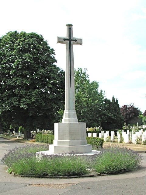
The cenotaph* occupies a central position, and part of the First World War burial section
lies behind.
|
The cenotaph* was created in 1920 on the site of a former mound in line with the central drive, and a section of adjacent ground was reserved for the fallen of the First World War. A similar area nearby was created for the fallen of the Second World War, and both sections are separately maintained by the Commonwealth War Graves Commission.For future planning the Council began to look at additional land which it owned for an additional cemetery. A lawn cemetery was suggested for King Harry Lane; later the proposal shifted to Porters Wood; but eventually the new cemetery was created at London Road. Meantime several authorities jointly planned for a crematorium on wooded land on the approach to Garston Manor.
 |
An early autumn view across to St Paul's Church where a commemorative tablet can be seen,
commemorating the fallen in WW1 from St Peter's Parish.
|
Many Fleetville residents find Hatfield Road Cemetery a restful location to walk and sit. It is very well maintained and has been a regular recipient of the national Green Flag open spaces Award Scheme. |
The house built for the cemetery superintendent. Today the title role is Cemetery Manager.
|
The local history group Fleetville Diaries has researched the stories of some fifty former residents who are laid to rest in this restful spot. A few of the graves have been restored in recent years, including that of Frederick Sander.
*While a cenotaph is an ancient generic term for a specific meeting place to honour the dead who are buried elsewhere, this particular structural type, called a Cross of Sacrifice, was designed for the Imperial (now Commonwealth) War Graves Commission by Sir Reginald Blomfield.